Showing 115142 items
matching heidelberg-kinglake-road
-
 Eltham District Historical Society Inc
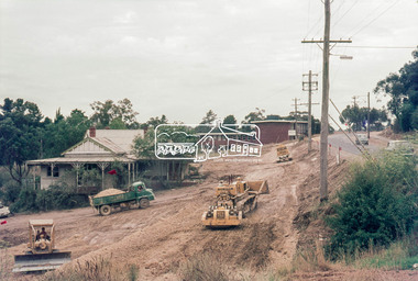
Photograph, Main Road widening, Eltham, c.March 1968, 1968
Immediately prior to duplication of Main Road. Gahan house on left and Shire Offices in background35mm Colour positive transparency Mount - Agfacolor Service (Blue stepped)duplication, eltham, eltham shire office, gahan house, main road, road construction -
 Eltham District Historical Society Inc
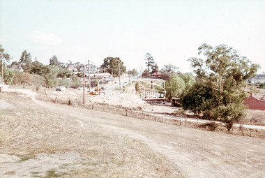
Photograph, Main Road widening, Eltham, c.March 1968, 1968
Duplication of Main Road. Gahan House almost completely demolished. Shillinglaw Cottage on right.35mm Colour positive transparency Mount - Agfacolor Service (Blue stepped)duplication, gahan house, main road, shillinglaw cottage -
 Eltham District Historical Society Inc
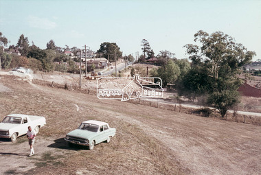
Photograph, Main Road widening, Eltham, c.March 1968, 1968
Duplication of Main Road. Gahan House almost completely demolished. Shillinglaw Cottage on right.35mm Colour positive transparency Mount - Agfacolor Service (Blue stepped)duplication, gahan house, main road, road construction, shillinglaw cottage -
 Greensborough Historical Society
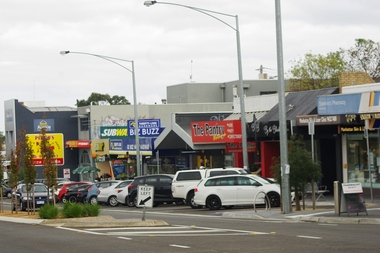
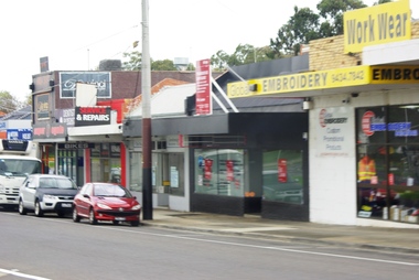
Photograph - Digital image, Marilyn Smith, Watsonia Road shopping strip, 2016, 24/05/2016
Watsonia Road shopping strip, Watsonia 2016. The strip is managed by the Watsonia Traders Association.Digital copy of colour photograph.watsonia, watsonia road -
 Greensborough Historical Society
Photograph - Digital image, Marilyn Smith, Watsonia Road shopping strip 2, 2016, 24/05/2016
Watsonia Road shopping strip, Watsonia 2016. The strip is managed by the Watsonia Traders Association.Digital copy of colour photograph.watsonia, watsonia road -
 Eltham District Historical Society Inc
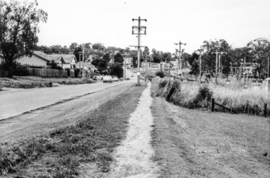
Photograph, Looking south along Main Road from just north of Elsa Court, Eltham, February 1968, Feb 1968
Shows where the future duplication of Main Road ends just north of Elsa Court.In February 1968 an unknown person took a series of photos from the Eltham Hotel at Pitt Street heading north along Main Road through the shopping centre to just north of Elsa Court covering the length of the section of Main Road which was duplicated shortly thereafter. Shows the condition and environment of the streesscape of Main Road, Eltham immediately prior to the duplication between Pitt Street and Elsa Court through the shopping centre. Also shows a number of shops and businesses that operated at that time.Black and white photographduplication, eltham, main road, elsa court, railway line -
 Eltham District Historical Society Inc
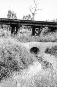
Photograph, Looking west from Main Road from just north of intersection with Diamond Street, Eltham, February 1968, Feb 1968
The watercourse passes under the road and railway at this point. Significant flash flooding occurred along this water course on Christmas Day 2011 causing significant damage to the railway line and road and flooding of Judge Book Village. The drain was swept away including the support pillars of the rail lines timber framework. Judge Book Village had some 40 units flooded before the water entered Diamond Creek. The water had flowed down and flooded Valonia Drive then Grove Street before flowing down the watercourse to Main RoadIn February 1968 an unknown person took a series of photos from the Eltham Hotel at Pitt Street heading north along Main Road through the shopping centre to just north of Elsa Court covering the length of the section of Main Road which was duplicated shortly thereafter. Shows the condition and environment of the streesscape of Main Road, Eltham immediately prior to the duplication between Pitt Street and Elsa Court through the shopping centre. Also shows a number of shops and businesses that operated at that time.Black and white photographduplication, eltham, main road, diamond street, watercourse, drainage, railway line -
 Heidelberg Golf Club
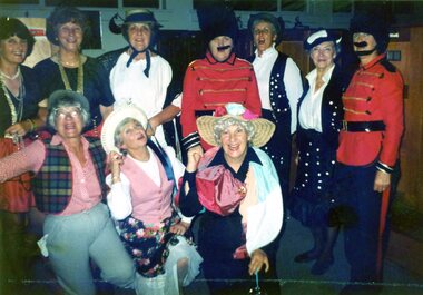
Photograph, Faye Lamb, Heidelberg Golf Club: Ladies' Christmas celebrations1990s: Lambeth Walk, 1992
Heidelberg Golf Club: Ladies' Christmas celebrations 1990s: Lambeth Walk. Photo 1: Margo Wilson, Elaine Morrison, Jo Kopp, Elizabeth Scanlon, Estelle Moran, Es Crampton, Faye Lamb, Roma Read, Liz Sanders, Gwyn Jones. Photo 2: Liz Sanders, Es Crampton, Gwyn Jones and Faye Lamb. Photo 3: Roma Read. Photo 4: Roma Read and Liz Sanders. Photo 5: Faye Lamb and Liz Sanders.5 Colour photographs and captionsladies' golf, hgc women's golf, ladies' christmas dinner -
 Eltham District Historical Society Inc
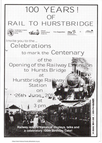
Folder, The Age et al, Centenary of the Eltham to Hurstbridge Railway extension, 2012
In 2012 local community groups acknowledged the centenary of the extension of the Railway line from Eltham to Hurstbridge which took place in 1912. Newspaper article: Automatic system signals the end of the station's tradition, The Age 20 June 2012. Material produced by Nillumbik Historical Society advertising centenary celebrations and providing history with photographs of the Eltham to Hurstbridge extension. The Heidelberg Historian newsletter of the Heidelberg Historical Society No 279, December 2013 (14 pages) including an article by David Watson "Prince's Bridge to Hurst's Bridge".29 pages, newspaper articleharry gilham collection, hurstbridge railway line, centenary celebrations, eltham railway station -
 Ringwood and District Historical Society
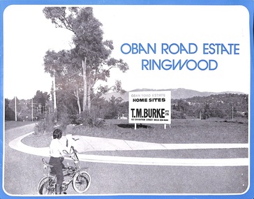
Flyer, Land Sale Advertisement, Oban Road Estate, Ringwood, Vic. - 1974
Double-sided folded page with blue border advertising sale of Oban Road Estate Ringwood building allotments. Front page features photograph of view from the estate towards Dandenong Ranges. Centrefold pages include terms of sale, layout and features of the subdivision, and summary of local services. Photocopy of typewritten price list for the 52 lots also attached.Subdivision includes Oban Road, Ambrie Avenue, Hendra Grove, and Mullum Mullum Road. (Agent) T.M. Burke Pty Ltd., 63 Exhibition Street Melbourne, Telephone 654 4144. -
 Whitehorse Historical Society Inc.
Article, $3.4 million road development opened
Article about the opening of home units for the agedArticle about the opening of home units for the aged in the former migrant hostel site in Rooks Road, Nunawading. With photo.Article about the opening of home units for the agedretirement homes and villages, harrowfield, john, mccutcheon, andrew, bradley, norman, bradley, agnes, rooks road, nunawading -
 Greensborough Historical Society
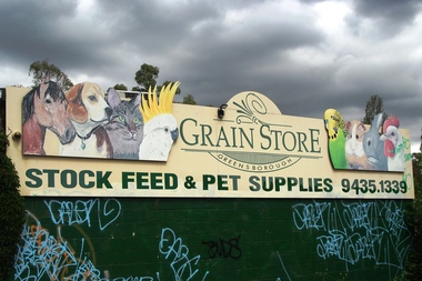
Photograph - Digital Image, Marilyn Smith, Greensborough Grain Store, 183 Para Road. Signs, 06/11/2017
This photograph shows signage at 183 Para Road when the building was used for Greensborough Grain Store.Digital copy of colour photographgreensborough grain store, para road greensborough -
 Greensborough Historical Society
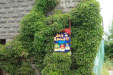
Photograph - Digital Image, Marilyn Smith, Greensborough Grain Store, 183 Para Road. Exterior, 06/11/2017
This photograph shows the exterior of the building at 183 Para Road when it was used for Greensborough Grain Store.In 2017, the Greensborough Grain Store closed its Para Road premises and now trades online.Digital copy of colour photographgreensborough grain store, para road greensborough -
 Eltham District Historical Society Inc
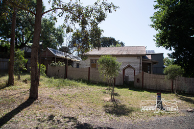
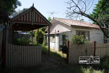
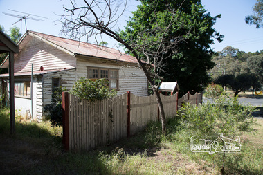
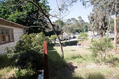
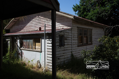
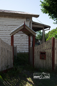
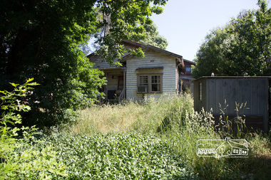
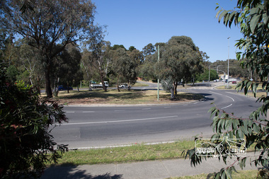
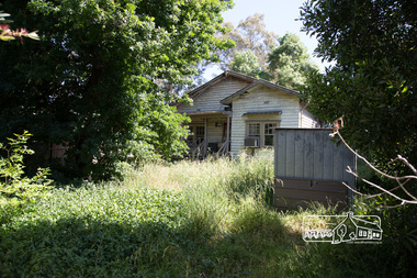
Photograph, Peter Pidgeon, Derelict house, 528 Main Road, Eltham, 13 November 2017, 13/11/2017
House dates back to early 1930s. Situated adjacent to intersection of Main Road and Fitzsimons LaneBorn Digitaleltham, streets, main road, fitzsimons lane -
 Eltham District Historical Society Inc
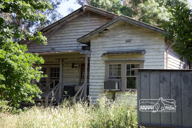
Photograph, Peter Pidgeon, Derelict house, 528 Main Road, Eltham, 13 November 2017, 13/11/2017
House dates back to early 1930s. Situated adjacent to intersection of Main Road and Fitzsimons LaneBorn Digitaleltham, streets, main road, fitzsimons lane -
 Eltham District Historical Society Inc
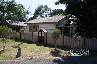
Photograph, Peter Pidgeon, Derelict house, 528 Main Road, Eltham, 13 November 2017, 13/11/2017
House dates back to early 1930s. Situated adjacent to intersection of Main Road and Fitzsimons LaneBorn Digitaleltham, streets, main road, fitzsimons lane -
 Eltham District Historical Society Inc
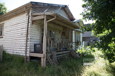
Photograph, Peter Pidgeon, Derelict house, 528 Main Road, Eltham, 13 November 2017, 13/11/2017
House dates back to early 1930s. Situated adjacent to intersection of Main Road and Fitzsimons LaneBorn Digitaleltham, streets, main road, fitzsimons lane -
 Eltham District Historical Society Inc
Photograph, Peter Pidgeon, Derelict house, 528 Main Road, Eltham, 13 November 2017, 13/11/2017
House dates back to early 1930s. Situated adjacent to intersection of Main Road and Fitzsimons LaneBorn Digitaleltham, streets, main road, fitzsimons lane -
 Eltham District Historical Society Inc
Photograph, Peter Pidgeon, Derelict house, 528 Main Road, Eltham, 13 November 2017, 13/11/2017
House dates back to early 1930s. Situated adjacent to intersection of Main Road and Fitzsimons LaneBorn Digitaleltham, streets, main road, fitzsimons lane -
 Eltham District Historical Society Inc
Photograph, Peter Pidgeon, Derelict house, 528 Main Road, Eltham, 13 November 2017, 13/11/2017
House dates back to early 1930s. Situated adjacent to intersection of Main Road and Fitzsimons LaneBorn Digitaleltham, streets, main road, fitzsimons lane -
 Eltham District Historical Society Inc
Photograph, Peter Pidgeon, Derelict house, 528 Main Road, Eltham, 13 November 2017, 13/11/2017
House dates back to early 1930s. Situated adjacent to intersection of Main Road and Fitzsimons LaneBorn Digitaleltham, streets, main road, fitzsimons lane -
 Eltham District Historical Society Inc
Photograph, Peter Pidgeon, Derelict house, 528 Main Road, Eltham, 13 November 2017, 13/11/2017
House dates back to early 1930s. Situated adjacent to intersection of Main Road and Fitzsimons LaneBorn Digitaleltham, streets, main road, fitzsimons lane -
 Eltham District Historical Society Inc
Photograph, Peter Pidgeon, Derelict house, 528 Main Road, Eltham, 13 November 2017, 13/11/2017
House dates back to early 1930s. Situated adjacent to intersection of Main Road and Fitzsimons LaneBorn Digitaleltham, streets, main road, fitzsimons lane -
 Eltham District Historical Society Inc
Photograph, Peter Pidgeon, Derelict house, 528 Main Road, Eltham, 13 November 2017, 13/11/2017
House dates back to early 1930s. Situated adjacent to intersection of Main Road and Fitzsimons LaneBorn Digitaleltham, streets, main road, fitzsimons lane -
 Eltham District Historical Society Inc
Photograph, Peter Pidgeon, Derelict house, 528 Main Road, Eltham, 13 November 2017, 13/11/2017
House dates back to early 1930s. Situated adjacent to intersection of Main Road and Fitzsimons LaneBorn Digitaleltham, streets, main road, fitzsimons lane -
 Kew Historical Society Inc
Plan, F R Simms & Son, Land for Private Sale: Cnr Victor Avenue and Mont Victor Road, Kew, 1950-1960
George Rimington established The Parkhill Nursery in 1877. By 1910, it was more commonly known as Rimington’s Nurseries and well known for its sale of violets. After World War II, Rimington’s Nurseries were gradually subdivided and sold. The 38 allotments were released in sections, including lots 34 to 36 on the corner of Mont Victor Road and Victor Avenue. Previous lots in the subdivision had bordered Burke Road, Rimington Avenue, Heather Grove, and Stoke Avenue. The selling point as it had been in comparable estates for a century were the proximity to transport, schools and churches, as well as the high location and excellent views. The subdivision plan shows most of the lots in the entire subdivision: 1-11, 13-26, and 34-38. Presumably, lot 12 and lots 27-33 were still to be released.Subdivision plans are historically important documents used as evidence of the growth of suburbs in Australia. They frequently provide information about when the land was sold on which a built structure was subsequently constructed as well as evidence relating to surveyors and real estate and financial agents. The numerous subdivision plans in the Kew Historical Society's collection represent working documents, ranging from the initial sketches made in planning a subdivision to printed plans on which auctioneers or agents listed the prices for which individual lots were sold. In a number of cases, the reverse of a subdivision plan in the collection includes a photograph of a house that was also for sale by the agent. These photographs provide significant heritage information relating house design and decoration, fencing and household gardens.Subdivision plan advertising five superb home sites among lots in Burke Road, Stoke Avenue, Victor Avenue, Mont Victor Road and Heather Grove.subdivision plans - kew, rimington avenue -- kew (vic.), heather grove -- kew (vic), stoke avenue -- kew (vic.), burke road -- kew (vic.), mont victor road -- kew (vic.) -
 Mt Dandenong & District Historical Society Inc.
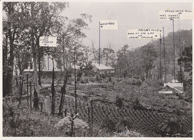
Photograph, 1908 View of the Kalorama Gap from Main Road With Labelling, 1908
Photograph with labels attached to front identifying buildings. View of the Kalorama Gap from main Road (now Ridge Road), looking across Walker's raspberry patch with Mountjoy coaching stables on the LHS and Mountjoy Guest House in centre. Price's house and shop on the RHS. This photograph has a detailed inscription on the back handwritten by John Lundy-Clarke in 1974.1908 View of the Kalorama Gap from main Road – now Ridge Road above Lot 2 of the Village Settlement. Looking across Walker’s raspberry patch with “Mountjoy” coaching stables on left. “Mountjoy” in centre. Prices house and shop on right with Hands “Beulah Tearooms” above Prices roof. On hillside beyond Hand’s is the slope now taken up by Kalorama Terrace. Walker’s well, then newly dug is in lower right hand corner below the tree fern head. Mt Kalorama is the hill top right. Track leaving Main Road left is Walker’s entrance drive.kalorama, kalorama gap, walker, beulah tea rooms, price, hand, mountjoy, mt kalorama -
 Surrey Hills Historical Society Collection
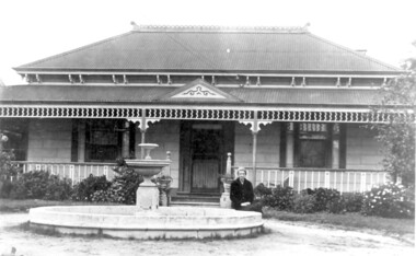
Photo, 'Spenceycroft', Canterbury Road
The photo is of ‘Spenceycroft’ at 654 Canterbury Road, Surrey Hills. For many years this home was hidden behind a large fence sheltering it from the noise of traffic along Canterbury Road, however it dates back to the very early days of settlement in the Surrey Hills area. Canterbury Road was then known as Delany’s Road. ‘Spenceycroft’ is thought to incorporate part of the original farmhouse built on the site by George Klepper, who planted a vineyard in the area. George’s family was one of a number of German families who settled in Surrey Hills during the later part of the 19th century. Later, the land associated with ‘Spenceycroft’ was worked as a dairy farm by James and Elizabeth Rayment. In recent years 'Spenceycroft' has been sold several times and has become increasingly derelict. Sold again in 2015 when it had become quite derelict, it was demolished and re-developed.A black & white photo of double-fronted Victorian style home with a fountain centre front and low foliage in front of the veranda. A woman is sitting by the fountain. 'spenceycroft', canterbury road, james rayment, elizabeth rayment, george klepper -
 Greensborough Historical Society
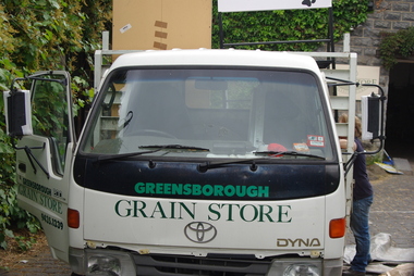
Photograph - Digital Image, Marilyn Smith, Greensborough Grain Store, 183 Para Road. Delivery truck, 06/11/2017
This photograph shows delivery truck at 183 Para Road when the building was used for Greensborough Grain Store.In 2017, the Greensborough Grain Store closed its Para Road premises and now trades online.Digital copy of colour photographgreensborough grain store, para road greensborough -
Greensborough Historical Society
Photograph - Digital Image, Marilyn Smith, Greensborough Grain Store, 183 Para Road. Closure notice, 04/10/2017
This Facebook post explains the move by Greensborough Grain Store to close the business at 183 Para Road in 2017.In 2017, the Greensborough Grain Store closed its Para Road premises and now trades online.Digital copy of Facebook postgreensborough grain store, para road greensborough