Showing 3045 items
matching highway
-
 Ringwood and District Historical Society
Photograph, Twenty photographs of Ringwood in frames, 1990
Returned to RDHS from Federation Estate Art GalleryPhoto 1 (7009a) - Former "Ringwood Mail" newspaper office, Adelaide Street, 1955, looking along laneway to west. Lane between Bamford's Timber Yard, corner Warrandyte Rd. and Maroondah Highway, and went to Melbourne St, later called Civic Place. Other buildings were Ham's Billiard Saloon, the two-story Renong Chambers, bottom left Jack Orr's clothes hoists and bottom right Horman & Woolhouse plumbers. All demolished for the building of Eastland in the 1960s. The photo shown is a typical example but may not be in the collection. -
 Ballarat Tramway Museum
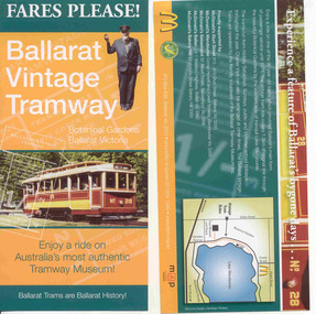
Pamphlet, Ballarat Tramway Museum (BTM), "Fares Please! / Ballarat Vintage Tramway", Aug. 2008
Yields information about how the BTM promoted the tramway, with the assistance of McDonalds. Design by the printer and Stephen Butler.Printed single sheet pamphlet, advertising BTM Vintage Tramway, titled "Fares Please!" featuring Frank Puls, a 1/- ticket and tram 26 on one side, map, details and McDonalds Wendouree on reverse. Printed in green, orange and black and white on light art paper. Includes BTM web address and McDonald's logo on rear, giving five locations of McDonalds, including the Western Highway at Ballan, Tourism and Museum Accreditation logos Introduced late August 2008. See Reg Item 2443 for previous version and 6123 for next version.trams, tramways, mcdonalds, btm, ballarat vintage tramway, botanical gardens -
 City of Kingston
Photograph - Black and white, 3 March 1954
Cheltenham and Moorabbin are suburbs within the City of Kingston that were originally established as rural market gardening communities The area is bordered by Highett and Mentone. The market gardens, farms and paddocks have gradually been sub-divided into housing and industrial estates. Highett is developed with residential homes but was also the site of major facilities such as the Highett Gas Works. This aerial image covers a diverse section of the City of Kingston, taking in the suburbs of Moorabbin, Cheltenham, Highett and Mentone Residential housing development is prominent along the Frankston Railway line and the area still retains extensive market gardens and paddocks yet to be converted to a large industrial and commercial zone.Aerial photograph of Mentone, Cheltenham and Moorabbin within the City of Kingston. The area depicted in this 1954 aerial view includes Warrigal Road and Centre Dandenong Road intersection (top left); Charman Road, Patty Street, Bourke Street, Collins Street Mentone (top right); Keys Road Moorabbin (bottom left); Bay Road, Cheltenham (bottom right), Friendship Square, Cheltenham Park, Victoria Golf Club and Jack Barker Oval are visible. Nepean Highway and the Frankston railway line run centrally through the image. Highett Gasworks is also evident.White handwriting and type [indecipherable]. White image of clockface White image of compass White type 42956 Black handwriting 3/3/54 Williams [indecipherable] Black pencil: S [arrow] Black ink: 3/3/1954cheltenham, moorabbin, mentone, highett, market gardens -
 Bendigo Historical Society Inc.
Map - LONG GULLY HISTORY GROUP COLLECTION: MAP OF LONG GULLY/CALIFORNIA GULLY AREA
BHS CollectionTwo copies of a map, printed on yellow paper, of the Long Gully/California Gully Area. It shows Eaglehawk Road from Craig Street then Mr Korong Road,to the Murray Valley Highway to just past Avenue Street. Sandhurst Road and Holmes Road are to the right. To the left is California Gully Road. Water Supply Purposes Reserve, Mental Hygiene Authority, Comet Hill State School Reserve, Agricultural Showgrounds and Recreation Reserve, Rubbish Reserve and two un-named State Schools are shown. Some contours are also shown.bendigo, history, long gully history group, the long gully history group - map of long gully/california gully area -
 Kiewa Valley Historical Society
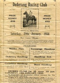
Programmes and Document - Dederang Racing Club, 1. January 1938 2. February 1924
The Dederang Race Club is a thoroughbred Race Club that manages a country racing venue in North East Victoria at the Dederang Recreation Reserve on the Kiewa Valley Highway. These races have been held annually since the mid 1850’s. The Dederang Picnic Race Club holds its one race meeting a year with the Dederang Cup in January. Thousands of dollars have been raised in that time for charity and the community through the effort of volunteers. The race club is made up of 100% volunteers and whilst not only organising the race meeting they voluntarily maintain the racecourse and facilities to a standard that allows local trainers to use the course throughout the year. Dederang Race Club celebrated its 150 year anniversary in January 2015 with spectators dressed in period race attire and the launch of a book commemorating the organisation "Rank Outsider-A non racegoers glance at 150 years of the Dederang Race Club2 Documents regarding Dederang Racing Club meetings 1. Original printed flyer for Dederang Race Club Annual meeting Jan 29, 1938. On buff paper 2. Official programme for Dederang Racing Club Annual meeting. February 6, 1924. Buff cardboard printed programme dederang racing club; programme; dederang cup; kiewa valley -
Bendigo Historical Society Inc.
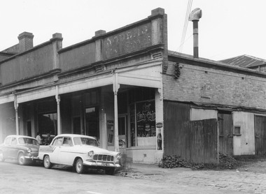
Document - Golden City Implements Foundry, Ironbark, Bendigo, 1960-1980s
This foundry had been a landmark in Mt Korong Road for many years. It began with an Osborne and Mitchell. After 1914 when mining declined, it became the Golden City Implement boundary and the name can still be seen painted on on the façade which faces the intersection of Marong Road (Calder highway) and Eaglehawk Road. The interior is a mass of used and un-used machinery scattered amongst modern lathes and more modern apparatus. The yard was a fascinating graveyard of past times, with old mining and agricultural scrap everywhere mixed up with coke and slag from the smelting sheds at the rear. A feature of the foundry was the manufacturer of cast iron lace. National Trust Survey Data Sheet and article from the Bendigo Advertiser November 4th 1981. Osbornes Ironbark Foundryhistory, national trust bendigo collection, bendigo, foundary, iron bark bendigo -
 Melbourne Tram Museum
Photograph - Last day of original Essendon Airport tram terminus, Ron Scholten, 7-10-1976
The original line to the Essendon Aerodrome was constructed in 1943 to serve the airport and aircraft construction. It was funded by the Commonwealth Government. By 1976, patronage to the airport terminus in Vaughan St had dropped, the crossing of the highway to the Tullamarine Airport opened in 1970, was dangerous, and the highway needed to be widened. The new terminus was a short distance to the north between Mathews Ave and the Highway. This series of photographs show the last day of operations to the original terminus and the changeover, which was done in about 7 hours. No buses were required. It was done by workers of the Melbourne and Metropolitan Tramways Board. The line was later extended to Airport West. .1 - W5 789, (Essendon Airport Route 59) about to turn from Mathews Ave into Vaughan St. Has new track and footbridge in the foreground. .2 - W5 791 on the siding or spur at the airport terminus, the last tram to use this facility. .3 - W2 571, at the Airport terminus alongside Vaughan St on the last morning of the use of this terminus. The Bundy clock can be seen behind the pole on the lefthand side and the Brick passenger shelter. Shows buffer stops, and Forestair hanger behind. .4 - W2 595 turning from Vaughan St into Mathews Ave. Has the tram stop No. 55 in the view. .5 - W5 839 turning from Vaughan St into Mathews Ave. Shows the flashing yellow light that gave some protection to the trams. .6 - W2 247 about to turn into Vaughan St. Driver about to reboard the tram. Note the new copper trolley wire is up for the new track but has been pulled to the west side using rope. .7 - W5 805, turning from Mathews Ave into Vaughan St, to the old Essendon Airport terminus. Has a new track in the foreground, and the overhead for the curves is still in position. .8 - W6 991 turning from Vaughan St into Matthews Ave, at 855am, the last tram from the old terminus. The track gang has commenced work to remove the outbound curve. Would appear four passengers waiting at the tram stop, two with lunch bags. Note the cattle grid in the foreground between the rails. New rails on the ground on the left-hand side. See Reg Item 6163 for further photos of this event.Yields information about the last day of the operation of the original Essendon Airport tram line.Set of 8 Kodachrome cardboard mount colour slides of the relocation of the Essendon Airport tram terminus 7-10-1976, by Ron Scholten.All slides have detailed descriptions on the reartrams, tramways, essendon aerodrome, essendon airport, closure, new tramways, route 59, w5 789, w5 791, w2 571, w2 595, w5 839, w2 247, w5 805, w6 991, w2 class, w5 class, w6 class, mmtb, trackwork -
 Melbourne Tram Museum
Photograph - Changing the Location of the Essendon Airport terminus, Ron Scholten, 7-10-1976
The original line to the Essendon Aerodrome was constructed in 1943 to serve the airport and aircraft construction. It was funded by the Commonwealth Government. By 1976, patronage to the airport terminus in Vaughan St had dropped, the crossing of the highway to the Tullamarine Airport opened in 1970, was dangerous, and the highway needed to be widened. The new terminus was a short distance to the north between Mathews Ave and the Highway. This series of photographs show the operation of a tram service during the changeover. Trams ran from the Niddrie crossover near Keilor Road to a temporary terminus just short of the worksite, with cars running "bang" road or the wrong way for one trip along either line. This would have been controlled by an Inspector at the Niddrie end. The work was done over a 7-hour period, including changing the overhead over. Work would have been completed after the changeover period. .1 - W5 800 at “temporary” Essendon Airport terminus, Cnr Mathews Ave, Vaughan St. after running “bang” road or the wrong way to this point from the Niddrie or Keilor Road crossover. Curves have been removed.. Has an Inspector chatting to a man with a hat standing alongside the tram. The shelter has a City of Keilor logo on it. .2 - W5 684, taken from the overbridge at the TAA stop - during the changeover of the tracks. Tram running “bang” road from Niddrie to the temporary terminus. .3 - SW5 787, temporary terminus in Mathews Ave, about to return to Niddrie as an “up” car on the “down” line. .4 - MMTB Track gang commissioning and placing rails at the new terminus with scrubber 10 waiting. Overhead in position with overhead for the curves partly removed. Mobile Crane on the left-hand side moving a formwork piece into position .5 - 10W cleaning new track at the new terminus. .6 - Rail Scrubber 10W at work cleaning head of rails where new concrete section. Has a TAA bus on the right side. .7 - W5 783 is about to be the first passenger tram to the terminus, at 3.50 pm About 20 workmen are completing the inbound or up track. .8 - W5 783 about to be the first passenger tram to the terminus, at 3.50 pm About 20 workmen are completing the inbound or up track.Yields information about the last day of the operation of the original Essendon Airport tram line and the works done for the new terminus.Set of 8 Kodachrome cardboard mount colour slides of the relocation of the Essendon Airport tram terminus 7-10-1976, by Ron Scholten. All slides have detailed descriptions on the rear trams, tramways, essendon aerodrome, essendon airport, closure, new tramways, route 59, mmtb, trackwork, w5 800, w5 684, sw5 787, scrubber 10w, w5 783, w5 class, sw5 class, taa airlines, city of keilor -
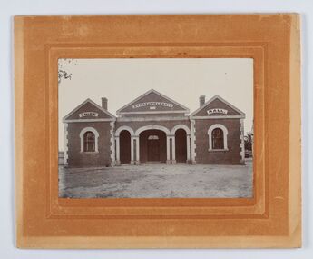
 Ringwood and District Historical Society
Photograph, Edwin G. Adamson A.R.P.S, Building fronting Adelaide St. Ringwood, buildings being portion of those known as 'The Block' 1963 (Eastland Litigation Photo)
This series of SS0380 photos are part of the "Eastland Litigation" launched in 1962 by the Whitehorse Traders Co-operative Association (WTCA), against the Ringwood Council's Interim Development Order of 1960. WTCA sought "orders from the Supreme Court of Victoria that the planning scheme was invalid" - See "The Eastland Litigation" chapter in "From Horse Shoes to High Heels - Ringwood Shopping Centre and Eastland 1858-2008" by Richard Carter, Bounce Books 2009.Written on back of photograph, 'Photo of the building fronting Adelaide St., buildings being portion of those known as 'The Block'. Photo showing shops on the west side of Adelaide St., near its junction with Maroondah Highway.. Fish and Chip shop" Stamped on photograph, 'In the Supreme Court 13 Aug. 1983' and 'Edwin G. Adamson...May 62'. -
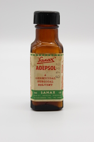 Glen Eira City Council History and Heritage Collection
Adepsol Bottle
This Adepsol Bottle is part of a Sanax First Aid Case which was used at the the former Carnegie Senior Citizens' Centre. The centre was located at 314 Neerim Road, Carnegie. When the Neerim Road facility closed, its activities were moved to the Carnegie Library and Community Centre. For Occupational Health and Safety reasons, Council no longer maintains first aid kits at senior citizens' centres. Brown glass bottle with red, green and white paper label with Sanax branding, and usage directions. Black plastic screw-top lid. Bottle has been decanted however some white powder residue remains. "Sanax" ADEPSOL/ A GERMICIDAL / SURGICAL / SOLVENT / THE SANAX CO. / 849-51 NEPEAN HIGHWAY / MOORABIN / TEL XU 2651 / Directions: Dilute 1 in 4 with warm water for bathing Wounds, dab dry with absorbent cotton, then apply Germicide and dressing. For removing Germs, Grease, and Dirt from Wounds and Burns before finally dressing Wounds. -
 Ringwood and District Historical Society
Document - Plan of Subdivision, Part of Crown Allotment 31B, Parish of Warrandyte - 1965
Map showing residential allotments numbered 1, 2, 4 and 5, on Through Road, Ringwood, Vic., with property dimensions, including weatherboard house and galvanised iron garage on lot 2.Kirkpatrick & Webber, Licensed Surveyors, Civil Engineers & Town Planners, Maroondah Highway, Ringwood, Telephone 8700321. Ref 3438C. Date 4th December, 1964. Amended 19th July, 1965. Notation: "The land coloured blue is a drainage and sewerage easement. Levels are to Board of Works Datum. Lot number 3 has been omitted." -
 Bendigo Historical Society Inc.
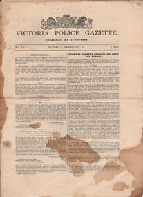
Document - VICTORIA POLICE GAZETTES COLLECTION: GAZETTE FROM FEBRUARY 1874
Victoria Police Gazette No. 7 dated Tuesday, February 17, 1874, containing notices about: incendarism, highway robbery and stealing from the person, housebreaking and stealing from dwelling houses, felonies and offences not otherwise described, miscellaneous information, stealing otherwise than from the person or from dwellings, horses and cattle, property lost, property found, missing friends, escaped prisoners and extracts from the New south Wales Police gazette. Also one page with a list of prisoners reported as discharged from the penal establishments during the week ending 66th february, 1874.essential services, police, victoria police gazette -
 Ballarat Tramway Museum
Photograph - Digital image, 1970s
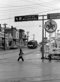
Yields information about the Bakery Hill Victoria St and the Caltex Service Station.Digital image, black and white, of No. 26 descending Bakery Hill to Stone's Corner, Victoria and Main St with the Caltex service station in the foreground. Has a lady with slacks walking across the road and a boy wheeling a bike down the footpath. Note the Highway direction signs and service station signage. O'Brien Motors and a book and record shop on the north side Bakery Hill Victoria St. shops. See Reg 4603 for the subsequent photo at this location. Photo taken by Peter Bruce 1970's and 1971, prior to the closure of the Ballarat tramway system. Peter's Title of image: "No. 26 Bridge and Vic1"trams, tramways, victoria st, main st, stones corner, bakery hill, tram 26 -
 Bendigo Historical Society Inc.
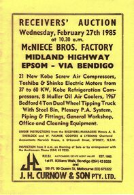
Document - IAN DYETT COLLECTION: AUCTION CATALOGUE - MCNIECE BROS FACTORY - BENDIGO
Yellow covered auction catalogue with black printing for a sale at McNiece Bros. Factory, Midland Highway, Epsom - Via Bendigo on 27th February 1985 under instructions from the Receivers/Managers Messrs A.G. Sherlock and W. Palmer, Coopers & Lybrand, Sydney. For sale were Air Compressors, Electric Motors, Refrigeration Compressors, Oil Air Coolers, 1967 Bedford 4 Ton Dual Wheel Tipping Truck with Steel Bin, P.A. System, Piping & Fittings, General Workshop, Office and Cleaning Equipment. J H Curnow & Son Pty. Ltd. Were the auctioneers.business, auctioneers, j h curnow & son pty ltd, ian dyett collection - auction catalogue - mcniece bros. factory - bendigo, a g sherlock, w palmer coopers & lybrand, j h curnow & son pty ltd, f c dyett, i m dyett, n f dyett, bolton bros. pty ltd print -
 Melbourne Tram Museum
Slide - Set of 3, Keith Caldwell, 9/03/1960 12:00:00 AM
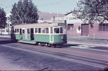
Set of 3 Agfa Colour slide, cardboard mount, by Keith Caldwell - .1 - W5 818, outbound in Elizabeth St North Melbourne, showing route 52, Fletcher St Essendon. Note the tramcar number above the headlight. Dated 12 March 1960. In the background is the F. Dawbourne Iron and Steel Merchants. .2 - W5 769 outbound at Haymarket after leaving Elizabeth St. Showing destination of Coburg Route 20. In the background is the Mayne Nickless building. Note the signpost showing the various highways out of town. Dated 9 March 1960. .3 - W5 727 - as for .2hand stamped "12 Mar '60" or "12 Mar '60"trams, tramways, elizabeth st, route 52, essendon, haymarket, coburg, route 20, w5 class, tram 818, tram 769, tram 727 -
 Flagstaff Hill Maritime Museum and Village
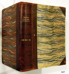
Journal - Women's Journal, Curtis Publication Company, Young Ladies Journal 1884 - 1885, ca. 1884
This is one of two books donated together and believed to have belonged to the Purvis family. The books were rescued from recycling. It has the name of C A. Purvis on the front endpaper. The other book from the same donor has the inscription "C. Purvis". The inscription on the back endpaper of this book is of interest, 'Edith Fox, Gheringhap, 1879' as it is earlier than the earliest journal in the book. Perhaps it is the birth date of Edith. It is also interesting that an notice was printed in the Geelong Advertiser in 1922 stating that Edith Susan Fox of Box Hill had an interest in land in Gheringhap. Gheringhap is a town on the Midland Highway, Victoria, 15 km northwest of Geelong, and 6.7 km southeast of Bannockburn. This is one of two journals of ladies fashion, fancy work and stories that reflect the interests of women the late 1800s. They are a useful source of historical information and include advertising and thought provoking articles .Young Ladies Journal 1884 - 1885; a collection of journals in a burgundy leather-bound spine and hardcovers with a black, blue, burgundy and cram pattern. The Journal contains illustrations and articles of a wide variety including fashion, fancy work and family reading. Inscriptions are on the spine and the front and back end pages. Inserted between pages is a loose Christmas Magazine from The Sun, dated 24th Dec 1954. Published by the Curtis Publication Company, Philadelphia, Pennsylvania, Inside the front cover on the first page, handwritten in pen; "C.A. Purvis 1955" Inscription, script in black ink; "Edith Fox / Gheringhap / 1879"flagstaff hill, flagstaff hill maritime museum and village, warrnambool, maritime museum, maritime village, great ocean road, shipwreck coast, young ladies journal 1884 - 1885, young ladies journal, 1884-1885, ladies journal, women's journal, fashion, fancy work, family reading, illustrated magazine, purvis, c a purvis, edith fox, gheringhap, 1879, edith fox gheringhap 1879 -
 Hume City Civic Collection
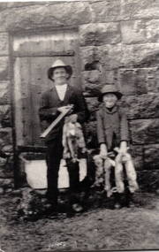
Photograph, Aitkens Gap Police Barracks, c1922
Frank Millett and his nephew Hopper Cahill are the two people standing by the building after spending the day shooting rabbits in 1922. They are standing in front of the Aitkens Gap Police Barracks. In the 1860s the gaol and stables were sold to George Millett and added to the Millett property. The Barracks and the new farm homestead were built by Mick Morrison. The Bald Hill Hotel at Aitkens Gap on the Bendigo Road (Calder Highway) was guilt by George Millett in 1854 and functioned until the gold began to run out after the Victorian Gold Rush of the 1850s. The Millett family continued to farm until 1967. The family also and operated hotels in the local area. A black and white photograph backed onto a white board of a man and a child holding some dead rabbits and standing in front of the doorway of a bluestone building. frank millett, george millett, aitkens gap gaol, hopper cahill -
 Bendigo Historical Society Inc.
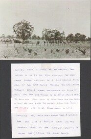
Document - Marong racecourse
Copied from a copy of an original photo loaned to me by Mrs. Jean Grimson. The photo shows patrons arriving at a race meeting being held at the racecourse fronting the Loddon Valley Highway opposite where Mrs. Grimson was living in 1985. The photo was thought to be taken around 1920? The Swan Hill train used to slow down for race patrons to jump off and enter the course from the "rear". The course was later transferred to land fronting the Myers Flat - Marong Road & Williams Road and with a railway siding on the Bendigo side of the railway crossing Myers flat (behind the Allies Hotel). Fron Q. C. Binks 29/01/2001.historic referenceHistoric photo circa 1920.race goers entering marong racecourse circa 1920, races -
 Bendigo Historical Society Inc.
Document - Notes on St Andrews Church Axedale, 1st Sept 2024
Although Presbyterians held religious services prior to 1854 it, was not till that year that Dr Nish arrived in Bendigo. It is known that Dr Nish preached to the shepherds in Axedale, long before the church was built, but where is not known. The foundation stone for the church was lain on September 30th, 1868. Axedale is a town in Victoria, Australia. It is located on the McIvor Highway, in the City of Greater Bendigo, east of Bendigo. It was surveyed and proclaimed in 1861. At the 2021 census, Axedale had a population of 984. The town is nestled alongside the Campaspe River which feeds out of Lake Eppalock. It has a golf course, tennis courts, a school, a pub and a convenience store/petrol station. It lies between Heathcote and Bendigo.Historical Notes on St Andrews Axedale 1868-1968 and the 150th Anniversary Church booklet March 2019.axedale, st andrews church axedale, dr nish -
 Lakes Entrance Historical Society
Photograph - Bullock Island Lakes Entrance, M Holding, 1988 c
Kalimna Heights showing development on Bullock Island including Pecks Factory. The Club Spit of dredged sand is acquiring vegetation. April Hamer dredge moored at Port Jetty, new bridge in place Lakes Entrance VictoriaAlso two colour photographs showing dumped sand on Bullock Island taken from Princes Highway lower parking bay June 2000. Donor L P Newspaper number 04209.1 size 10 x 15 cm and 04209.2 size 10 x 15 cm|Two colour photographs of Gippsland Ports Facilities taken from waterway numbers 04208.3 and 04208.4 size 10 x 15 cmColour photograph taken from Kalimna Heights showing development on Bullock Island including Pecks Factory. The Club Spit of dredged sand is acquiring vegetation. April Hamer dredge moored at Port Jetty, new bridge in place Lakes Entrance Victoriaislands, waterways, gippsland lakes -
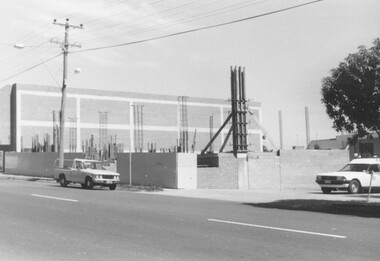 Ringwood and District Historical Society
Photograph, Building Construction: 27-29 Ringwood St, Ringwood. 1982 (2 views)
Written on back of photograph SS0245a: , "Framing the columns under the first floor of 27-29 Ringwood Street. Social Security buildings in background. Shows Waltons 'Blimp' in sky right of power pole. It was tethered over their store on highway. 25/3/82". On back of SS0245b: "Preparing the foundations of 27-29 Ringwood St. 25/3/82" -
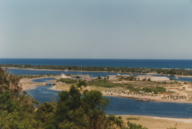
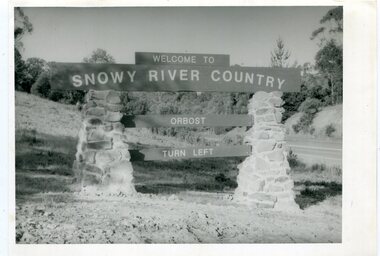 Orbost & District Historical Society
black and white photographs, second half 20th century
These photographs are pictorial records of the signs at the Orbost town entry points.Three black / white photographs. 3277.1 is a sign on stone pillars at the top of a hill - "WELCOME TO SNOWY RIVER COUNTRY ORBOST TURN LEFT". 3277.2 shows a road leading into a town. There is a sign on the left - "ORBOST" and a service station on the right. 3277.3 shows a row of newly planted trees between a road and a school.3277.1 on back - "WELCOME TO SNOWY RIVER COUNTRY - ORBOST sign - Princes Highway - Newmerella" 3277.2 on back - "East Gippsland Shire Sign on eastern approach to ORBOST., in Salisbury Street, near Orbost Secondary College" 3277.3 on back - "Tree planting in Salisbury St, Orbost in front of Orbost High School looking west towards Orbost township"photographs-orbost orbost-township-entry salisbury-street-trees town-entry road-signs-orbost -
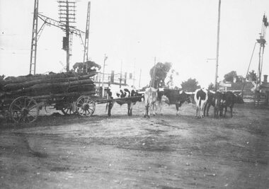 Ringwood and District Historical Society
Photograph, Old railway crossing near Ringwood station, c1925
Black and white photograph (2 copies- 1 large, 1 smaller)Typed below one photograph: "Bullock team at old railway crossing near station, taken from Maroondah Highway. Circa 1925." Written on back of other photograph: "Rail crossing 1924. Team owned by Hussey. Opposite Adelaide Street and Ringwood House. Corner of Station Street and Greenwood Avenue on right." Blood Brother's store in background. -
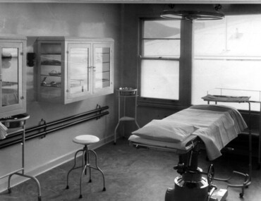 Kiewa Valley Historical Society
Photograph Tawonga District Hospital, Theatre at Tawonga District Hospital, 1949/50
The original Tawonga District Hospital was situated at the corner of Ryder's Lane and Kiewa Valley Highway. The construction was initiated by the Hospital and Charities Commission with considerable assistance from the State Electricity Commission.The building was transported from Bonegilla where it was originally a part of the Bonegilla Military Hospital. It started with 12 beds and eventually increased to a total of 35 beds. "Add ons" provided theatre, offices, stores and Nurses Home. It was officially opened on 24th September, 1949. Up until this time, any person requiring hospitalisation had to travel to Yackandandah. This photograph is of the theatre and there was no anaesthetic or recovery rooms. While rather primitive by todays standard, it met the demands of the construction days as well as that of the Kiewa Valley community. Shows the rather spartan conditions and equipment of the theatre in the original Tawonga District Hospital compared to the present day hospital. Black and white photograph of the operating theatre in the original Tawonga District Hospitalhospital, operating theatre, tawonga -
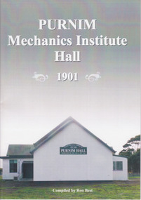 Warrnambool and District Historical Society Inc.
Booklet, Ron Best, Purnim Mechanics Institute Hall 1901, 2014
Brief history of Purnim Mechanics Institute HallThis is a paper back book of 24 pages. It has a white back cover and a grey/white front cover with a coloured photograph of the second Purnim Hall. The printed material is black on a white background. non-fictionBrief history of Purnim Mechanics Institute Hallpurnim, mechanics’ institutes, warrnambool -
 Flagstaff Hill Maritime Museum and Village
Journal - Women's Journal, Curtis Publication Company, The Ladies' Home Journal 1891-95, ca. 1891
This is one of two books donated together and believed to have belonged to the Purvis family. The books were rescued from recycling. It has the name of C Purvis on the front endpaper. The other book from the same donor has the inscription "C. A. Purvis". The inscription on the back endpaper of the other book belonging to C. Purvis is of interest, '"Edith Fox, Gheringhap, 1879"' as it is earlier than the earliest journal in that book. Perhaps it is the birth date of Edith. It is also interesting that an notice was printed in the Geelong Advertiser in 1922 stating that Edith Susan Fox of Box Hill had an interest in land in Gheringhap. Gheringhap is a town on the Midland Highway, Victoria, 15 km northwest of Geelong, and 6.7 km southeast of Bannockburn.This is one of two journals of ladies' fashion, fancy work and stories that reflect the interests of the late 1800s. They are a useful source of historical information and the articles available for sale.The Ladies' Home Journal 1891- 95; a collection of women's journals in a burgundy hardcover book with a leather-bound spine and leather-reinforced corners. The journals are illustrated magazines and include fashion, fancy work and family reading, Published in Philadelphia, America by the Curtis Publishing Company. The binder was made by G Mercer, Geelong. A printed blue label is on the inside front cover. An inscription is on the corner of the front fly page.On spine: "THE LADIES' HOME JOURNAL" Within two concentric oval outlines "G. MERCER / GEELONG" and it nthe centre "BINDER" Handwritten in black pen and crossed out "E. F." Handwritten in blue pen "C. Purvis"flagstaff hill, flagstaff hill maritime museum and village, warrnambool, maritime museum, maritime village, great ocean road, shipwreck coast, young ladies journal, ladies journal, women's journal, edith fox, gheringhap, fashion, fancy work, family reading, illustrated magazine, curtis publishing company, philadelphia, young ladies journal 1891-95, 1891-1895, purvis, g. mercer of geelong, stationery -
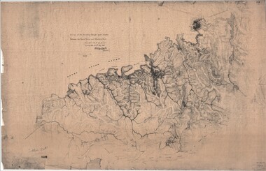 Ringwood and District Historical Society
Map, Survey of Dividing Range between Yarra Yarra and Western Port - William Wedge Darke, 1843
Extract - Ringwood, Place of Many Eagles - Hugh Anderson (1974): William Wedge Darke, from Hereford, England, was a nephew of John Helder Wedge of the Port Phillip Association, who was also a surveyor. William's most important work was probably his survey of the Dividing Range and the country between the Yarra River and Western Port, completed in May 1843, and during which he made a traverse between the Mullum and Dandenong creeks along the higher ground that he labelled the "best line of road from Melbourne". This road was for many years the major route to Gippsland and to the higher country about Alexandra and Mansfield, sometimes known as White Horse Road, and now Maroondah Highway.Surveyor's relief map of features to the east of Melbourne including Yarra Yarra River, Mullum Mullum Creek, Anderson's Creek, Dandenong Creek.Transmitted to the Surveyor General with my letter of 10th May 1843 (signed) Wm Wedge Drake, Assistant Surveyor. Scale: two inches to a mile. Descriptive remarks include upstream area of Yarra River - "impassable, appears to have been formerly a lake", and to the south - "barren and scrubby swamps of the Western Port Country". Marked tracks include "best line of road from Melbourne", "track to Dandenong", "Road to Port Albert may probably be found on this range", "Best line to Upper Yarra". Several huts also marked. -
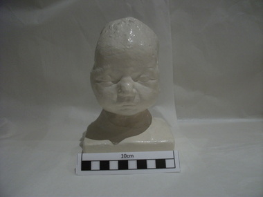 Royal Australian and New Zealand College of Obstetricians & Gynaecologists (RANZCOG)
Plaster cast of the head of the first baby to be delivered under anaesthesia by the use of ether, 1847
This a cast of the first baby to be delivered under anaesthesia, by the use of ether, in Edinburgh on 19 January 1847. The famous physician James Young Simpson, Professor of midwifery at Edinburgh University, attended this birth and wrote about it in the Monthly Journal of Medical Science 1846-7 Vol.7, p649-640. The cast of the baby's head was given to Lance Townsend, Professor of Obstetrics and Gynaecology, University of Melbourne by Robert Kellar, then Professor of Midwifery and Diseases of Women at the University of Edinburgh, when Professor Townsend was visiting Edinburgh. There is at least one other plaster copy; one is located at Wood Library-Museum of Anesthesiology, 520 North Northwest Highway, Park Ridge, IL 60068-2573, USAReplica of a new born baby's head, painted plaster, life size. The model of the head shows a large indentation of two and a half inches in the skull on the left side. The baby was delivered through a severely deformed pelvis, suffered a large indentation to the skull and did not live.obstetric delivery, anaesthesia -
 City of Greater Bendigo - Civic Collection
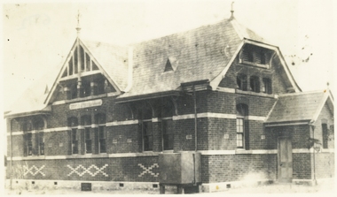
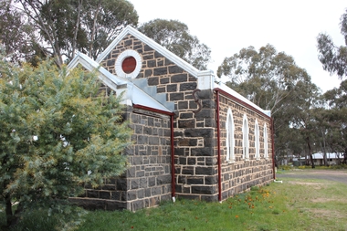
Photograph - Strathfieldsaye Shire Hall
The district of Strathfieldsaye was proclaimed in 1861 and named a Shire on the 17th September in 1866. It remained a shire until amalgamation in 1994 when it became part of the City of Greater Bendigo. The shire was located 8 km to the south- east of Bendigo and covered an area of 601 square kilometres and extended from the Calder Highway to the Coliban and Campaspe Rivers. The shire's administration activities were centred at the Strathfieldsaye Shire Hall which was built in 1869 at a cost of £700 based on a design by George Steane, the shire surveyor and built by George Pallett of Sandhurst. Constructed of red brick, the hall has a unique ventilation system with hollow walls open at the top and bottom to ensure a draught to cool the building in summer. Framed and mounted photograph of the Strathfieldsaye Shire Hall. Verso; W M Robinson / Photographer / Mundy Street Bendigostrathfieldsaye shire hall, shire of strathfieldsaye, strathfieldsaye shire council -
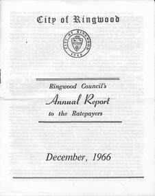 Ringwood and District Historical Society
Pamphlet, F.P. Dwerryhouse, Town Clerk and Treasurer, Ringwood Council's Annual Report To The Ratepayers - December 1966, 1966
City of Ringwood community information annual report for 1966, including sections covering Finance, Sanitary Service Charge, Municipal Library, Memorial Clock Tower, Reserves, Civic Centre, Maroondah Highway Reconstruction, Other Road Works, Building Activity and Development - Education, MacRobertsons Pty. Ltd. & Travellers' Facilities (Ringwood Station), Appreciation - Decimal Currency Conversion, Annual Special Clearance of Refuse, Garbage Removal, Fly Control, Immunisations, Infant Welfare Centres, Retention of Native Flora, Home Help Service, Dogs, Horse Riding, Fire Hazards and Burning Off, Secondary School Grants, and list of Council Representatives.rinx