Showing 1845 items matching "rivers in victoria"
-
 Lakes Entrance Historical Society
Book, Stevens M I, Township of Cann River, Parish of Noorinbee, County of Croajingolong, 1977
... Cann River, Victoria, Australia ...An account of the development of the Cann River town and district in Gippsland, Victoria, compiled for the 50th. anniversary of the Cann River school. Includes list of pupils and head teachers, information on other schools, and recollections of residents.settlers, schools, township -
 Lakes Entrance Historical Society
Photograph - Johnsonville School, Lakes Post Newspaper, 1996
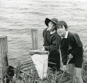
Black and white photograph of two children Coban Duffy and Nicole Rijs with net on small jetty, collecting samples from the Tambo River as part of water watch program at primary school Johnsonville Victoriaschools, students, activities -
 Lakes Entrance Historical Society
Photograph - Johnsonville School, Lakes Post Newspaper, 1996
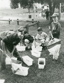
Black and white photograph of small group of children one named as Scott Froud on bank of Tambo River, with nets and buckets of water, samples collected for the water watch program at primary school Johnsonville Victoriaschools, activities -
 Bacchus Marsh & District Historical Society
Map, General Plan for Water Supply Works, Shire of Bacchus Marsh 1887
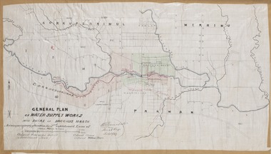
Debate about water supply and its planning and development took place in the Bacchus Marsh region from the 1850s through into the twentieth century. This plan was part of documentation to support an application for an additional loan of money from the Ministry of Water Supply to the Bacchus Marsh Shire Water Supply Trust. The plan includes the route of a proposed water channel in the Parwan area, and other features of water supply infrastructure such as the location of standpipes and gates are also shown on the plan.A single page paper map showing a general plan for the supply of water in the Bacchus Marsh area.The plan shows the route of the 'Main Channel' near the Werribee River and a proposed route for a Parwan Channel. The location of 'Dryden's House' near the Werribee River is also shown and the locations of land held by T. (Tom) Oliver and the Racecourse Reserve in Maddingley. Scale 40 chains to 1 inch. The plan is signed by Bacchus Marsh Shire Engineer, W.E. Standfield. The map is pasted into a bound volume containing 76 maps or plans in total. High resolution digital image stored on BMDHS computer network. General Plan of Water Supply Works in the Shire of Bacchus Marsh. Accompanying application for 2nd additional Loan. Original Waterworks district. Additional area. W.E. Standfield, 30/8/87.water supply, water supply maps, water supply bacchus marsh, irrigation, bacchus marsh victoria maps -
 Flagstaff Hill Maritime Museum and Village
Document - Poster, Warrnambool Steam Navigation Co, ca.1938
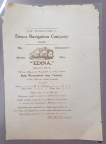
This poster is typical of posters displayed by steam packet companies of the mid-19th to early 20th centuries. It advertises the passage and freight available on a local coastal trader. The steamships operated between the major ports along the western coast of Victoria between Melbourne and Portland. The traveller was not guaranteed the passage times due to possible weather changes. Discounts were offered for return trips within a month of the ticket's issue. The price of freight included 'lighterage', which was the service of a smaller vessel called a 'lighter' expressly designed to transport goods between ship and shore. This particular poster has been recreated; it advertises the services of the screw steamer SS Edina. The information on the poster applies to the years between 1871 and 1873. During that period the Master of the Edina was Captain John Thompson, the Edina was owned by the Warrnambool Steam Navigation Company and the secretary of the firm was Thos. Mackay. The passenger fares are in line with fares from that period, as seen in a display advertisement published in the Hamilton Spectator on January 17th, 1872. The 1853 Glasgow-built Screw Ship Edina had a long life. The ship served in both the Crimean War and the American Civil War. The Edina also traded in UK and European waters. The Henty family of Portland, Victoria, purchased Edina in 1863 for use as a coastal trader. The Edina had several owners and spent many years of service along the South West Coast of Victoria between Melbourne and Portland. The vessel transported passengers and freight in Port Phillip Bay, between Melbourne and Geelong, between 1880 and 1938. After 84 years of service, the Edina was renamed ‘Dinah’ and was stripped down for use as a lighter. The vessel was broken up in 1957 at Footscray, Melbourne. The remains of Edina’s hull can be found in the Maribyrnong River, Port Phillip Bay. The poster was owned by the donor's grandfather, Bruce Duff (1922-2003) who was an avid sailor and a lover of nautical history. He and his wife Mona (1924-2014) were buried in Portarlington Cemetery, Victoria. Duff would have been about 13 years old when the Edina was finally retired from service in 1938. His interest in the Edina could have come from a trip on the vessel or from watching it in operation in the ports along the coast. Duff has collected this poster as a memento of the Edina and is likely to have preserved it at a much later date when the lamination process was readily available. [Flagstaff Hill's collection includes a photograph of the Edina at the Moorabool Street Wharf, Geelong, which was in Duff's locality. The References for this poster include a link to Museum Victoria's photograph of two boys watching the Edina from a jetty.] Flagstaff Hill's Village has its own 'Examiner' Office where volunteers demonstrate the historic printing press in that building. They use original letter-type to create posters, print labels onto lolly bags and designs on fabrics. One of the volunteer printers has produced a poster closely resembling the donated poster. His replication includes a woodcut of the ship, which he skilfully crafted himself.This poster advertises the sailing of the steamer SS Edina and the information has local and State significance for its association with the trading ports of the Edina, and the associated names on the poster; Warrnambool Steam Navigation Company, Captain John Thompson and Thos. Mackay. This poster's message has a strong connection to the history of the businesses and community of Warrnambool and the people of Port Phillip Bay, where it was a passenger ferry for many years. The poster is an example of advertising used by shipping agents in the mid-19th to early 20th centuries. Its information includes the accurate costs to passengers and freighters and the type of timetable the vessels were likely to follow. The poster's connection with the Screw Steamship Edina is historically significant, as the vessel was the longest serving screw steamer in the world. The ship spent its first nine years overseas then arrived in Melbourne. The vessel's work included running the essential service of transporting cargo and passengers between Melbourne and the western Victoria ports of Warrnambool, Port Fairy and Portland. The Edina is listed on the Victorian Heritage Database VHR S199. Poster, A3 size, brown text on cream paper, laminated. Re-created poster of the Warrnambool Steam Navigation Company (Limited) advertising passage and freight on its Screw Steamship, SS Edina. It states days, times and fees for passage and freight from Warrnambool to Melbourne, and return. It names the ship's Master, Captain John Thompson and the Company's Secretary, Tho. Mackay. It displays a line drawing of a 3-masted ship with full sails.Printed image [side profile of a 3 masted vessel, bow facing left] Printed text includes "The Warrnambool Steam Navigation Company (Limited). The Company's Steam Ship "EDINA", Captain John Thompson, Will leave Melbourne for Warrnambool on Tuesdays, returning from Warrnambool every Thursday, At Five o'clock p.m. (weather permitting). FARES: Saloon £2 0 0 Steerage £1 0 0 Saloon return £3 0 0 Saloon return £1 10 00 - Children under 13 years half fares - Refreshments supplied onboard at a moderate scale of charge. Freight, including lighterage, - From Melbourne to Warrnambool - 12s per ton; from Warrnambool to Melbourne, 15s per ton. Passengers are requested to obtain their tickets at the offers, and shippers to make early application for space. Return tickets available for one month from date of issue. - THO. MACKAY, secretary. "warrnambool, shipwreck coast, flagstaff hill, flagstaff hill maritime museum, maritime museum, fair maid of judea, steam navigation, pleasure steamer, ss edina a, trade 19th century, travel 19th century, warrnambool to melbourne, warrnambool to geelong, warrnambool to port fairy, warrnambool to portland, screw steamer, coastal trader, crimean war, american civil war, gold export, h r h duke of edinburgh, warrnambool steam packet company, stephen henty, captain john thompson, chief engineer john davies, lady bay, lighter edina, port phillip bay steamers, vhr s199, dinah, warrnambool steam navigation company, advertising poster, shipping agent, flier, maritime village, flagstaff hill maritime museum & village, great ocean road, block printing, woodblock printing, relief printing, moorabool st wharf, western steam navigation company, tho. mackay, re-created poster -
Lakes Entrance Historical Society
Book, Fairweather, Keith Mc D, Brajerack - Mining at Omeo and Glen Wills
A Description of the mining industry in the northern part of of the Shire of Omeo, Victoria,dealing with the settlements of Omeo, Glen Wills, Sunnyside, Saltpetre Creek and Wombat, also Cobungra River and Newrush Creek. Aboriginal identities IllustratedRuth Clarkaboriginals, mines and mining, land settlement -
 Lakes Entrance Historical Society
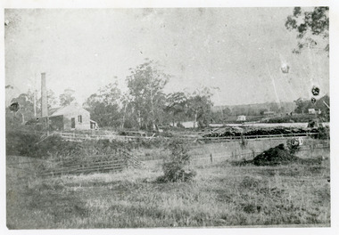
Photograph - Johnsonville Creamery, 1895
Original creamery was at Bruthen, ,shifted to Johnsonville in March 1892, run by the Chilled Butter Company until 1899 with Mr G Lucas, last manager.Black and white photograph of the Johnsonville Creamery, situated on the southern bank of the Tambo River on Punt Road. A small timber building with gable roof, large chimney adjacent, punt landing and roadway on opposite bank. Johnsonville Victoriadairying, primary industry -
 Lakes Entrance Historical Society
Photograph - JCD, 1920
Also one other photograph enlargement 16 x 21.5Black and white photograph showing the SS JCD on the Mitchell River with crowd of excursionists onboard, buildings on bank in background, three people sitting on lifeboat on top deck. Bairnsdale Victoriaships and shipping, waterways -
Lakes Entrance Historical Society
Book, Cuthill William J, The River of Little Fish, 1970
A history of Traralgon Victoria is early settlement 1840 to its creation as a city in 1906's includes some photographsR B Harrissettlers, explorers, religion -
 Lakes Entrance Historical Society
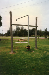
Photograph, 1999
In late 1958 bore put down in an attempt to obtain good quality water for a reticulated town water supply. Water unsuitable, but during drought years when water supply from Nicholson River was restricted, water from this bore available for public use. Bore plugged, structure removed December 2000. Site marked with plaque March 2001, by Lakes Entrance Historical Society.Colour photograph of the head works including feed pipe of water bore sunk in late 1958 on the Public Reserve bound by Marine Parade and the highway approach to North Arm Bridge, Lakes Entrance, Victoria.water supply, public utilities -
Lakes Entrance Historical Society
Book, Bird E C F, The Geomorphology of the Gippsland Lakes Region, 1978
A geomorphological study of the Gippsland lakes Region Victoria with reference to the effects of the artificial entrance, settlement, erosion and salinity on the changes to the configuration of the lakes, rivers, and coastline.natural history, waterways, genealogy -
Lakes Entrance Historical Society
Book, Land Conservation Council Victoria, Final Recommendations Gippsland Lakes hinterland Area, 1983
1980 report and recommendations of the Victorian Land Conservation Council, for the balanced use of public land in teh gippsland Lakes Hinterland includes reserves schools forests rivers foreshores and other public sites. Map and diagrams added.topography, parks, waterways -
Lakes Entrance Historical Society
Book, Bird E C F, The Silt Jetties at the Mitchell River, 1972
The first of a series of scientific and historical studies of Gippsland to be published by the Bairnsdale Advertiser. The formation of the Mitchell River Silt Jetties is explained, and schemes for protecting this unique and fragile area of Victoria are suRuth Clarkgenealogy, waterways, topography -
University of Melbourne, Burnley Campus Archives
Newspaper - Newspaper Cutting, The Age, Victorian Horticultural Society, 1862
(1) Photocopy of article in "The Age" 30 January, 1862 p7. (2) Similar article from "the Argus" 30 January, 1962 p4. Description of the annual general meeting of the Victorian Horticultural Society. Description of a competition for a design and that the decorative part of the garden was nearly complete and open to the public. Donors of plants named including Rule (Californian Redwood?) Extension of Swan Street through Richmond Park, past Pic Nic Station to the Gardens and River Yarra.the age, the argus, victorian horticultural society, horticultural society of victoria, monthly meeting, competition for design of experimental gardens, burnley gardens, rule, californian redwood, donations of plants, pic nic station -
 Wodonga & District Historical Society Inc
Photograph - Bethanga Bridge
The Bethanga Bridge was built between 1927 and 1930 as a joint venture between Victoria and New South Wales and was a key element of the River Murray Waters Agreement. It consists of nine spans of 82 metres long. Each span is supported between double reinforced concrete pylons and a riveted steel camel back Pratt truss. The overall span of the bridge is a length of 752 metres. It was completed in 1929 at a cost of £194,000. The road deck was initially constructed from timber but was replaced in 1961 with a concrete waffle slab deck 7.7metres wide. In 1961 the bridge deck and truss structure were raised 300 millimetres to allow for the enlargement of the lake. The bridge was designed in NSW by road engineer Percy Alan and the trusses were built by the Charles Ruwolt Pty. Ltd. Charles Ruwolt Pty. Ltd. was originally established by Charles Ruwolt as a foundry at Wangaratta in 1902 and transferred its operations to Richmond, Melbourne in 1914. By 1938 it had become one of the biggest engineering companies in Australia. After Charles Ruwolt’s death in 1946, Vickers Ltd. acquired the company and in 1948 the firm became known as Vickers Ruwolt Pty. Ltd. Because of the Bethanga Bridge’s unique location, over the waters of a dam with the border running down the centre of the body of water, the Bethanga Bridge is the only built structure shared by both Victoria and New South Wales. As the border of New South Wales aligns with the southern bank of the Murray River all of the other bridges along its length are deemed to be in New South Wales. The Bethanga Bridge is listed on both the New South Wales State Heritage Register and the Victorian Heritage Database. In 2015 the Bethanga Bridge was nominated for a heritage award by the Institution of Engineering Australia.These images are significant because they document the construction of a bridge which links Victoria and New South Wales and has been recognised for its historical, technical and engineering significance.A collection of photos documenting the construction of the Bethanga Bridge which links the States of Victoria and New South Wales as part of the construction of the Hume Dam .bethanga bridge, hume dam constuction, charles ruwolt, percy allan engineer -
 Stawell Historical Society Inc
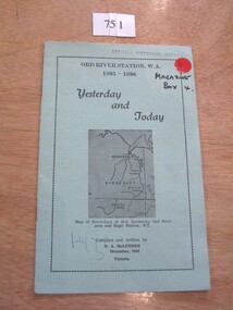
Book, N.A. McLennan, Yesterday and Today - Ord River Station WA 1895 - 1896 by N A McLennan, 1965
John McLennan's Period as Manager of the Ord River Station. W.A. adjoining Negri Station N.T., was 1895-6. The whole area consisted of 3,365,000 areas under a number of leasesand the then owner was Mr W.H. Osmand, who lived at "The Sycamores" four miles east of Stawell in Victoria. The Distance to Ord W.A. is 4,000 Miles.LIght green card cover with border, inside print and picture of a map Ord River Station W.A. 1895-1896 Yesterday and Today Map of North-East of W.A. Kimberly Ord River area Negri Station N.T. Complied and written by N.A. McLennan December 1965 1965 Victoriastawell, mclennan family -
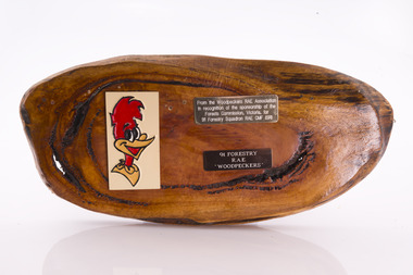 Forests Commission Retired Personnel Association (FCRPA)
Presentation plaque from the "Woodpeckers"
In the post-war era from 1947 to the mid-1980s, the Forests Commission sponsored Australia's only military sawmilling unit, the 91 Forestry Squadron. It was a special reserve unit of the Royal Australian Engineers (RAE). Established and commanded by Commission forester and WW2 veteran, Major Ben Benallack, the "Woodpeckers" as they were known comprised a small pool of specialised soldiers capable of rapid mobilisation in the event of need. Several other Victorian departments such as the State Electricity Commission (SEC) did the same thing who supported a construction squadron based at Newborough in the Latrobe Valley. The scheme created a very active and capable part-time military group that completed many worthy projects across the State. In addition to their military training, the Woodpeckers operated bush sawmills, built timber bridges along the Murray River, the Snake Island Jetty, forest roads and performed various demolition tasks.Presentation plaque from the "Woodpeckers" Mounted on polished wooden burl forests commission victoria (fcv) -
 Eltham District Historical Society Inc
Photograph, C.S. Wingrove, Secretary, Eltham District Road Board 1858-1871; Shire Secretary, Shire of Eltham 1871-1904, 1858-1871
Charles Symons Wingrove, J.P. (1829-1905) arrived in Victorian in 1851. He had trained as an engineer, but tried his luck on the goldfields. In 1857 he was appointed as Secretary to the Eltham District Roads Board only one year after its foundation. He was to hold the position with the Board and later the Eltham Shire Council for total of 47 years. He also held the position of engineer for a large part of this period. During part of this time he was also secretary to the Heidelberg Shire Council. Over this period he was responsibly for an area stretching from Clifton Hill to Healesville, along the northern bank of the Yarra River. Other positions included Secretary to the Victorian Agricultural Society over along period.Wingrove was a main figure in the Municipal Association of Victoria. By the time he retired he was recognized as the “Grand Old Man” of Victorian local government. In 1858 Wingrove had a brick cottage built in Main Road near the State School and he lived here until his death. One room was uded as the Board and Council office. His descendants owned the house until 1974. It was later used as a psychiatric clinic. The park opposite the cottage has been named Wingrove Park in his honour. He is buried at St Helena with other members of his family. Age (Melbourne, Vic. : 1854 - 1954), Tuesday 18 July 1905, page 5 ABOUT PEOPLE. A conspicuous figure in northern municpal history, Mr. Charles Symons Wingrove, has passed away. He was for many years secretary and engineer for the shire of Eltham, and prior to the formation of the shire held the position under the old road board, his official connection with the district dating from beyond 1857. For about twelve years he also filled the position of shire engineer for Heidelberg council while retaining his other post, and the immense territory under his professional control, reaching from the boundary of Collingwood up to Healesville, was a matter of fatherly pride and interest to him. He arrived in Victoria in 1851, and was 76 years of age at his death. Mr. Wingrove retired from the position in the Eltham council only about a year ago. The interment will take place in St. Helena Cemetery, near Eltham township, today. Secretary, Eltham District Road Board 1858-1871 Secretary for the Shire of Eltham 1871-1904. Nearly 50 years service to the local community. For about twelve years he also filled the position of shire engineer for Heidelberg council. Reproduced Page 137 "Pioneers & Painters" This photo forms part of a collection of photographs gathered by the Shire of Eltham for their centenary project book,"Pioneers and Painters: 100 years of the Shire of Eltham" by Alan Marshall (1971). The collection of over 500 images is held in partnership between Eltham District Historical Society and Yarra Plenty Regional Library (Eltham Library) and is now formally known as the 'The Shire of Eltham Pioneers Photograph Collection.' It is significant in being the first community sourced collection representing the places and people of the Shire's first one hundred years.Digital image Print 25 x 20 cmc.s.wingrove, charles symons wingrove, eltham district road board, sepp, shire of eltham pioneers photograph collection, shire secretary, wingrove cottage, pioneers and painters, shire of eltham, councilor, municipal officer -
 Greensborough Historical Society
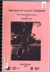
Book, Victoria Archaeological Survey, The Plenty Valley Corridor: the archaeological survey of Aboriginal sites / by Isabel Ellender 1989, 1989_
This archaeological survey of th Plenty Valley was conducted by Isabel Ellender in 1989 for the Ministry of Planning and Environment. The area studied is north of Greensborough to Whittlesea. A number of Aboriginal sites were identified and recommendations made for the future.103 p., illus., maps. Plastic spiral binding.plenty river, aboriginal heritage sites -
 Lakes Entrance Historical Society
Photograph - Cowrie Bay, 1980c
Skipper John Britton, Scott Hobson?, thought to be in mud in Tamar River, Tasm 2011Colour photograph of fishing boat Cowrie Bay which appears to be just outside Cunninghame Arm, the western side of the entrance and hummocks in background. Lakes Entrance Victoriafishing industry, ships and shipping, waterways -
 Warrnambool and District Historical Society Inc.
Booklet - Warrnambool Visitor's Handbooks 1979-2024, Collett, Bain and Gaspar, Printers, 1979-2014
This is a collection of eight Warrnambool Visitor handbooks produced between 1979 and 2014 by the City of Warrnambool Tourist Information Centre. They contain maps of Warrnambool, lists of services, accommodation and tourist attractions as well as many advertisements for local businesses.These handbooks give a useful snapshot of businesses and tourist attractions in Warrnambool for each of the years covered. (1979, 1980, 1986, 1990, 1993, 1994, 1995, 2014)[.1a] A 48 page booklet with white pages and blue printing. The front cover has a coloured photograph of Flagstaff Hill with boats on a man made lake in the foreground looking across Lake Pertobe toward South Warrnambool. [.1b] A coloured bifold brochure. The front cover has a fisherman on a cray-boat holding a crayfish in the lower section. The top quarter has a blue back ground with white printing. The rear cover is red and has small photos of the Hopkins River and the Framlingham Forest. [.2] A 48 page booklet with white pages and black printing. The front cover is white with black writing on the left hand side and a colour photograph of the Loch Ard peacock. The Warrnambool Premier Town stylised logo of seven Norfollk pines above blue waves is in the top right hand corner. There is a blank ink Warrnambool Library stamp underneath the logo. The rear cover has photographs of The Twelve Apostles and the Hopkins Falls and the Premier Town Logo [.3] A 40 page booklet with mainly black printing on white paper. There are three fold out maps of Warrnambool and the surrounding district. The glossy cover has a black background with a colour photograph of the Twelve Apostles taken at sunset. The rear cover has three small of Proudfoot's boathouse on the Hopkins River, Flagstaff Hill, and the main beach area. The front cover has black writing inside to peach coloured rectangles. The inside rear cover has a fold out coloured tour map of Western Victoria. [.4] A 40 page booklet printed on glossy white paper with coloured photographs and black and red printing. The front cover has a photograph of The Twelve Apostles surrounded by a white border. There is red writing in the upper border. There is a sandy coloured writing superimposed across the bottom of the photograph and a Victoria's Shipwreck Coast logo in the bottom right hand corner. [.5] A 44 page booklet printed on white paper with black printing. The cream coloured cover has a pale red rectangle with blue writing on the right hand facing edge and includes two stylised Norfolk pines and with waves underneath. There is is an intersecting blue rectangle with cream printing. [.6] A 48 page booklet printed on white paper with black printing. The cover is brown with a cream vertical strip containing black writing on the right hand side. There is a stylised map from Geelong to Mount Gambier showing the Great Ocean Road across the cover. [.7] A 48 page booklet printed on white paper with black print. The glossy colour cover has a photograph of a Southern Right whale fluke. There is white printing on a the blue background of the sky and sea. The bottom left hand side of the front cover has a Tourism Victoria logo made of jigsaw puzzle pieces. The back cover has a stylised coloured map of The Great Ocean Road located in a white rectangle at the top of the page. Within the rectangle is a small map of Australia locating Victoria and the part of Victoria covered by the map. [.8] A 64 page A5 coloured booklet printed on white pages with black print. The white front cover has black and grey print with a colour photograph of two people holding coffee cups watching four race horses being exercised on the beach and in the water of Lady Bay in the early morning. The bottom right hand corner has a Tourism Victoria logo. The rear cover has a mainly blue back ground with a pink orange and green colour splats contains words advertising the 2015 Fun 4 Kids Festival [.1a] Warrnambool The Heart of Victoria's Great Southwest Visitor's Handbook [.1b] Warrnambool City for all seasons; The Heart of Victoria's Great Southwest [.2] Warrnambool visitor's handbook Warrnambool Premier Town 1979-1982 [.3] Warrnambool Handbook Victoria [.4] Warrnambool The Shipwreck Coast [.5] Welcome to Warrnambool Warrnambool Visitors Handbook 1993-1994 [.6] Welcome to Warrnambool Visitors Handbook 1994-95 Rear cover: Warrnambool Centre of Victoria's Shipwreck Coast on Australia's Great Ocean Road [.7] Warrnambool Shipwreck Coast - Great Ocean Road; You'll love every piece of Victoria; Visitors Handbook [.8] Warrnambool Great Ocean Road Official Visitor Guide; It's a wonderful Warrnambool; You'll love every piece of Victoria visitvictoria.com. Rear Cover Live entertainment.Workshops.Creativity.Action 28 June - 5 July 2015 Australia's Best Children's Festival F4K The ultimate winter school holiday adventure Fun 4 kids festival Warrnambool For more information visit Fun4kids.com.au Warrnambool great Ocean Road Victoriawarrnambool, visitor handbooks, tourist information guides, warrnambool maps -
 Lakes Entrance Historical Society
Photograph, 1930c
Sepia photograph taken from a boat on Mitchell River. Appears to be one of the ferries travelling between Bairnsdale and Lakes Entrance. Boy on bow of boat. Victoriawaterways, boats and boating, tourism, transport -
 Lakes Entrance Historical Society
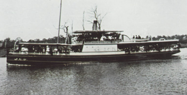
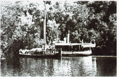
Photograph - S. S. Lady Harriet, 1908
1 x Black and white photograph copied from a book 9.5 x 14.5.Black and white photograph showing S S Lady Harriet at the cliffs on the Tambo river. The Lady Harriet barge on left of S S Harriet, well vegetated cliff behind the vessels. Swan Reach Victoria1908 S S Lady Harriet at cliffs in Tambo River and her barge (on back)jetties, ships and shipping, waterways, topography -
 Bendigo Historical Society Inc.
Postcard - BLANCHE SLY POSTCARD COLLECTION, 1900 - 1920
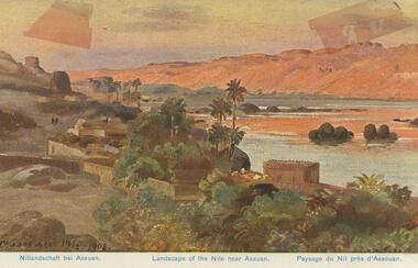
Postcard Album of Blanche Sly. Postcards stored in Folder 81 (49 postcards). 1403.1 - 1403.28 Grey linen look cover with picture of a small sailing boat pasted centre front pf cover. Partly torn sticker on lower LH corner. Blanche Victoria SLY Born: 11 Oct 1890, daughter of William and Hannah Sly Address: 1913; Loddon Vale Address: 1980; 100 Barnard Street Bendigo Died: Bendigo 12 June 1982, buried Bendigo G3 William Sly: Born: 1856 at Smythesdale, Victoria Married in Victoria in 1887; Hannah Theilman Died: Bendigo 1937, buried Bendigo G1 Hannah Sly Nee Theilman Born: 1866 Married in Victoria in 1887; William Sly Died: Bendigo 1948, buried Bendigo G3 See additional Research .Postcard Album of Blanche Sly containing 49 postcards. See 1403 Coloured painting of a landscape of the river Nile near Assuan. Egypt Small village with palm trees on near bank and desert dunes on far bank. . Addressee - Mrs. W Sly, Loddon Vale, via Pyramid, Victoria Sender - Pte S Olgaiti Not datedpostcard, collector, blanche sly -
 Lakes Entrance Historical Society
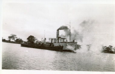
Photograph - W H Edgar, 1917
Typed note in album describes the photoBlack and white photograph showing PWD dredge WH Edgar with hopper barge during dredging operation at mouth of Mitchell River. Silt jetty at back. Bairnsdale Victoriaboats and boating, dredges -
 Lakes Entrance Historical Society
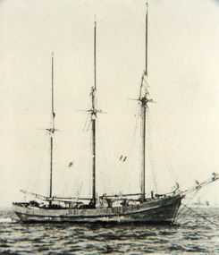
Photograph - Coringle, 1910 c
Schooner 'Coringle' built 1905 to carry maize from Snowy River to Lakes Entrance. (See book Sailing Ships and Paddle Wheels, by J C BUll, page 139)| Also photocopy of page of bookBlack and white photograph of auxiliary schooner Coringle moored possibly at Marlo. It has three very tall masts, sails furled. Marlo Victoria waterways, ships and shipping, transport -
 Lakes Entrance Historical Society
Photograph - Ethel BT, 1900c
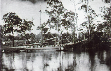
Captain ..Limschow, crew member A J legg and two others were rescuedBlack and white photograph showing schooner Ethel BT in Tambo River near Bennetts Brook. Sheds and buildings and post and rail fences on farm in background. Swan Reach Victoria boats and boating, waterways -
 Warrnambool and District Historical Society Inc.
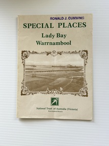
Pamphlet - Special Places Lady Bay Warrnambool, Philprint Warrnambool, 1989
This pamphlet was produced for the Warrnambool Branch of the National Trust of Australia (Victoria) for Heritage Week, April 16-23, 1989 and contains information written by Warrnambool residents about their locality. This was a co-operative venture by people with a common interest in protecting the natural environment near their home. Areas covered in the written information include: Formation of the Coast, Archaeological survey, Gunditjmara History, vegetation, history and recreational uses of the Lady Bay area. The map shows special places of interest including past and present navigational aids, sites of shipwrecks and other historical places of interest. The Warrnambool Branch of the National Trust was originally formed in March 1969 and merged with the Port Fairy Branch in late 1970. In October 1979, the Warrnambool Branch was reformed and operated into the late 1990's. This is an example of a publication produced by the Warrnambool Branch of the National Trust Australia (Victoria). It provides historical information and perspectives of the recreational uses in and around Lady Bay Warrnambool.An A2 piece of buff coloured thick paper folded into eight to make an A5 pamphlet. The front cover has green printing with the National Trust symbol of three eucalyptus leaves in green. There is a brown sepia photograph showing a view across Lady Bay with the suspension bridge across the Merri River in the foreground, Viaduct Road in the middle ground and the breakwater in the background. There is a purple inked stamp on the top right hand corner. The rear cover has brown writing and includes logos of bodies who assisted with the publication. There is a brown line drawing of the viaduct and pier at the Warrnambool Breakwater. The inside of the unfolded pamphlet contains a map of Lady Bay and adjacent area showing places of interest and shipwrecks marked in red circlesFront cover: Special Places Lady Bay Warrnambool National Trust of Australia (Victoria) Warrnambool Branch Ronald J. Cummingwarrnambool, lady bay warrnambool, national trust australia victoria warrnambool branch, heritage week 1989, lady bay shipwrecks -
 Lakes Entrance Historical Society
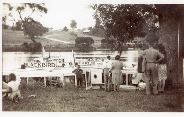
Photograph - MV Earlie, 1950 c
Also one black and white enlarged copy 13 x 21 cmBlack and white photograph showing tourist launch Blackbird and MV Earlie moored in Tambo River. Shows tourists about to board vessels. Two smaller boats tied to opposite bank, buildings above the road. Large old tree on right of people. Boat skipper in white coat and cap. Swan Reach Victoriawaterways, boats and boating, tourism -
 Lakes Entrance Historical Society
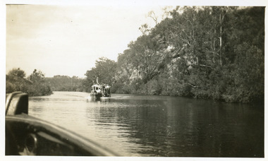
Photograph - Tambo River, 1950 c
... Upper Victoria Photograph Tambo River ...Road between Swan Reach and Tambo Upper follows river bank opposite cliffsBlack and white photograph print showing tourist launch, possibly 'MV Blackbird' on Tambo River below the cliffs, taken from another boat. Tambo Upper Victoria waterways, boats and boating, tourism