Showing 112730 items
matching tracks/roads
-
 Whitehorse Historical Society Inc.
Article, Have your say in Strathdon House, 2015
Whitehorse Council is inviting community feedback.Whitehorse Council is inviting community feedback on the draft report for conservation of the Strathdon Homestead and orchard in Springvale Road, Forest Hill.Whitehorse Council is inviting community feedback. strathdon homestead, springvale road, forest hill, city of whitehorse -
Glenelg Shire Council Cultural Collection
Photograph - Photograph - Main Breakwater construction, Portland, 29/08/1952
Port of Portland Authority ArchivesFront: MAIN BREAKWATER ACCESS ROAD 29/8/52 - black print Back: Purple PHT Stamp - print 4/7 Neg No. P1 Date taken 29.8.52 Subjectport of portland archives, main breakwater, construction, lady bay, portland, harbour -
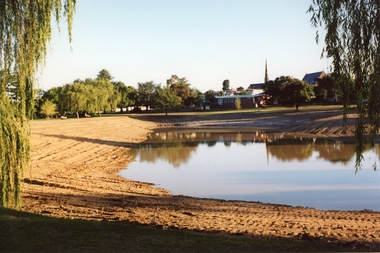 Stawell Historical Society Inc
Photograph, Cato Lake looking from Sloane Street -- Coloured
Cato Lake view from Sloane Street. This photo is one of three showing Stawell Council Works deepening Cato Lake in February c 2002. Tracks from a tractor can be seen all round the lake. Willows branches hang either side of the view with trees along the horizon. The Presbyterian Church tower, Senior Citizen room and Anglican Church can be seen amongst the trees in the background.Coloured photograph of Cato Lake. The view is from Sloane Street and the lake was in the process of being lowered for the deepening of the lake by Shire Council Works. Tractor tracks can be seen all round the lake. Willows hang either side of the view with trees along the horizon. The Presbyterian Church tower in the background near the Senior Citizen room and Anglican Church to the right.Date on back of photo in biro 12.2.2002.stawell -
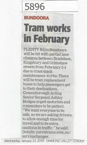 Greensborough Historical Society
Newspaper Clipping, Diamond Valley Leader, Tram works in February, 23/01/2019
Plenty Road in Bundoora will be hit with partial lane closure between Bradshaw, Kingsbury and Grimshaw Streets from February 2-4 (2019) due to tram track maintenance works.News article 1 page, black text.plenty road bundoora, closure, tram track maintenance works, public transport -
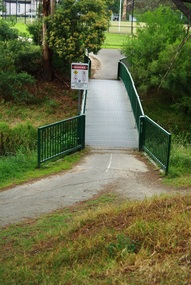 Greensborough Historical Society
Photograph - Digital Image, Marilyn Smith, Willinda Park bridge to Simms Road, 06/11/2017
Willinda Park is situated in Beatrix Street Greensborough. It has an athletics track and field and is adjacent to the Plenty River. This photograph shows the footbridge across the Plenty River to Simms Road Reserve.Digital copy of colour photographwillinda park, beatrix street greensborough, athletics, plenty river -
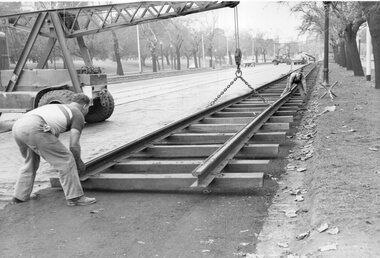 Melbourne Tram Museum
Photograph - Set of 3 - Temporary track St Kilda Road, Melbourne & Metropolitan Tramways Board (MMTB), 1950's
Photographs showing setting up temporary track in St Kilda Road using a mobile crane. One photo shows the temporary connection in the Alexandra Gardens area, late 1950s?Yields information about setting up temporary track in St Kilda Road for major tramway reconstruction.Series of 3 black and white photographs.Some photos have pencil marks on rear.trams, tramways, trackwork, rails, track materials, track repairs, sleepers, equipment, st kilda road -
 Melbourne Tram Museum
Pamphlet, Public Transport Victoria (PTV), "Route 1 and 6 Buses replace trams", Feb. 2019
Issued for track work in Holmes Road and Nicholson St Brunswick between 23 Feb. and 7 March 2019 impacting routes 1 and 6. Produced by Yarra Trams and the PTV.Yields information about track work in Holmes Rd and Nicholson St Brunswick 2019.Pamphlet - full colour DL 6 fold.trackwork, tramways, nicholson st, holmes road, brunswick, route 1, route 6 -
 Melbourne Tram Museum
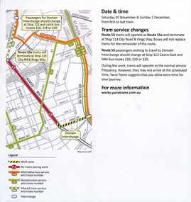
Letter, Yarra Trams, "Tram track renewal and tram stop upgrade works", 1/06/2012 12:00:00 AM
Set of two A4 sheets, printed both sides, titled "Tram track renewal and tram stop upgrade works", for the reconstruction of the intersection of Power Street, Wallen Road and Riversdale Rd.", Saturday 30/6 to 5/7/2012. Work included the construction of the platform stop, relocation of the cross over from Riversdale Rd to Wallen Road and the reconstruction of the track into the Hawthorn depot. Gives timetable for works, access arrangements for the apartments and the tram depot. Has a map showing work locations. Dated 18/6 and 22/6/2012, signed by John Uiterwijk, Manager Renewals Yarra Trams.trams, tramways, yarra trams, trackwork, wallen rd, riversdale road, riversdale junction, power st, hawthorn depot -
 Eltham District Historical Society Inc
Photograph, M. North, Main Road, Eltham near Fitzsimons Lane Roundabout, Dec 1985, 1/12/85
Two colour photographs of Main Road, ElthamSouth between Falkiner Street and Bolton Street at the roundabout of Fitzsimons Lane, Eltham, Dec 1985Noted on 463B 'See 1934 small black and white snap of flooded bridge and the same two shops. This snap taken from same location, Dec 1985. Old Eltham Park on right of photo The two shops at left (Ansel and Muir) Road ahead crosses new bridge over the Diamond Creek, Eltham Main Road now dual highway, through Lower Plenty to this bridge'main road, eltham, eltham south, fitzsimons lane, round about, falkiner street -
 Port of Echuca
A black and white postcard, 1906. or. 1916
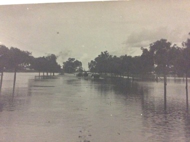
The postcard is significant because it shows the extent of the flood in the early 20th Century. The bridge crosses the Southern Cross channel which had been built as part of the Murray Darling irrigation system. There is a vehicle on the bridge either being towed by bullocks or horses. Floodwaters cover the whole view.The postcard is significant because it shows the extent of the flood in the early 20th Century. The bridge crosses the Southern Cross channel which had been built as part of the Murray Darling irrigation system. It is also near the water filtration plant which filters the town's water supply. There is a vehicle on the bridge either being towed by bullocks or horses. Floodwaters cover the whole view.A black and white postcard showing Goulburn Road, Echuca East, in either the 1906, or 1916 floods.Printed on the back are the words; W. Grimwood Echuca. POST CARD. Correspondence Address Only Kodak Australia. Hand written on the back are the words 1906 or 1916? Southern Cross bridge near filtration plant. Goulburn Road, Echuca East.floods, goulburn road, echuca east, pullicino, j, postcard, southern cross channel, water filtration plant -
 Bendigo Historical Society Inc.
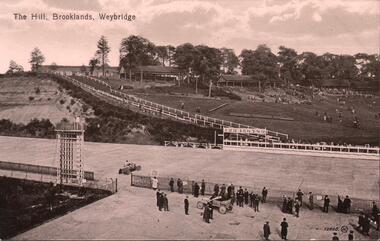
Postcard - BASIL WATSON COLLECTION: RACETRACK BROOKLANDS, WEYBRIDGE
black and white postcard. On top 'The Hill, Brooklands, Weybridge' Image shows racetrack, two cars - one on track, one outside fence line. Men standing on edge of track in foreground.Valentines's Seriesevent, sports, vehicle race track -
 Lakes Entrance Historical Society
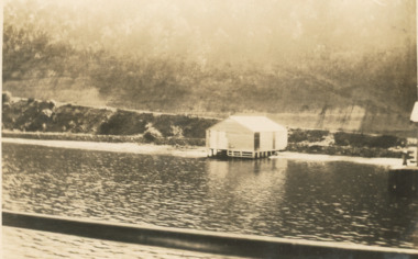
Photograph, Nyerimilang Jetty, Reeves channel Gippsland Lakes Victoria, Easter 1928
Sepia photograph of track to Nyerimilang Jetty soon after opening showing track down side of cliff to jetty and boat shed adjacent to shore, Reeves channel Gippsland Lakes Victoria waterways, boats and boating -
 Sunbury Family History and Heritage Society Inc.
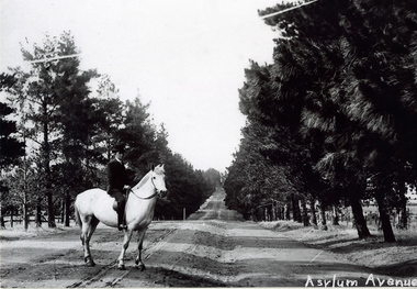
Photograph, c1900s
The man on the horse was photographed close to the main entrance of The Avenue which was the main approach to the former Sunbury Asylum. In later years the conifer trees were replaced with oak trees and today The Avenue is still the main road leading into Jacksons Hill, the housing estate that has been built on the former Sunbury Asylum land.The housing development on the former Sunbury Asylum site began in the 1980s. A black and white photograph of a man astride a white horse standing on an unmade road with an avenue of tall trees growing on either side of the formed road. A building is just visible in the distance.the avenue, sunbury as, jacksons hill -
 Whitehorse Historical Society Inc.
Photograph, Forster Street, Mitcham, 5/09/1958 12:00:00 AM
Black and white photo of Forster Street, Mitcham.Much activity in this corner of the City of Nunawading about the same time. ( Previously poorly served with civic functions)|- Road making of previous muddy, potholed tracks|- Construction of Heatherdale Railway Station|- Construction and commissioning of Heatherwood Primary School.o'rourke, l. -
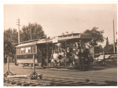
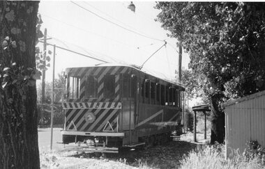 Ballarat Tramway Museum
Photograph - Black & White Photograph/s, Ron Hann, Jan. 1963
Yields information about the scrubber tram parked at the end of "0" road at the SEC Ballarat depot and the yard itself.Black and white print on heavy matt photographic paper of the Ballarat Scrubber or track cleaning car at the back of "0" road at the depot, adjacent to the tennis court and other sheds. Source of photo - same as Reg item 3841 - Ron Hann, note added 2/2010.On rear in pencil "Scrubber Ballarat 1963"tramways, trams, depot, scrubber tram, tram scrubber -
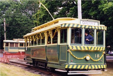 Ballarat Tramway Museum
Photograph - Colour Photograph/s - set of 2, Simon Jenkins, 12/12/1998 12:00:00 AM
Set of two colour photograph: .1 - No 18 at the end of the Access track, with Christmas decorations, and No. 27 in background. . .2 - Front of No. 11 on 7 road, with Twin Lakes sign and showing Sturt St. West Photos by Simon Jenkins, 12/12/1998 on Fujifilm paper.On rear in blue ink: - .1- "18 in Christmas attire and 27 in regular service. 12/12/98" .2 -"11 at the depot 12/12/98"btm, depot, christmas, access track, tram 18, tram 27, tram 11 -
Whitehorse Historical Society Inc.
Pamphlet, Creating a New Strathdon Community, 2001
Creating a New Strathdon Community.Creating a New Strathdon Community: A vision for the redevelopment of Strathdon's Jolimont Road site, contains Plans of Proposals for site development.Creating a New Strathdon Community.strathdon community, strathdon orchard, matheson, charles, matheson mary, aged people -
Whitehorse Historical Society Inc.
Document, Blackburn Road Rail Crossing Removal Project, 2012
Information update issued by VicRoads.Information update issued by VicRoads regarding the planned removal of the rail crossing at Blackburn Road, and improvements to the Blackburn Railway Station.Information update issued by VicRoads.blackburn railway crossing, blackburn railway station, blackburn road, blackburn -
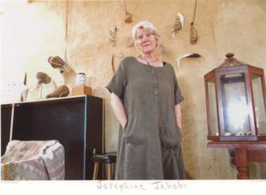 Lakes Entrance Historical Society
Photograph, EG Newspaper, Josephine Jakob artist shown in her studio with some of her creations Colquhoun Road Lakes Entrance
artist shown in her studio with some of her creations Colquhoun Road Lakes EntranceColour photograph of Josephine Jakob artist shown in her studio with some of her creations Colquhoun Road Lakes Entrancearts and crafts, events -
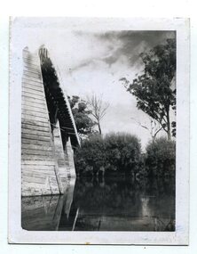 Orbost & District Historical Society
black and white photographs, C1970
These photographs are of the 1922 road bridge across the Snowy River at Orbost. This bridge over the Snowy River was opened on July 4 1922. It was constructed in 1922 alongside the previous suspension bridge. Its building was a combined effort of the Victorian Railways and the Country Roads Board at a cost of 35,000 pounds. It was replaced in 1976 by the present bridge after several major floods.This bridge was replaced in 1976 after several major floods. These photographs are pictorial records of the 1922 brige.Two small black / white photographs of a road bridge across a river. 3248.1 is a close-up of wooden pylons.on label on back - "Snowy River Bridge at Orbost 1922 Bridge"bridge-orbost snowy-river-bridge -
Whitehorse Historical Society Inc.
Article, Arterial support, 8/08/1990 12:00:00 AM
Article in Nunawading Gazette dated 8 August 1990.Article in Nunawading Gazette dated 8 August 1990 about resident support for extension of Eastern Freeway to Springvale Road, Nunawading.Article in Nunawading Gazette dated 8 August 1990. roads and streets, eastern freeway, local government elections -
Whitehorse Historical Society Inc.
Document, Warrawong Estate, 27/10/1962 12:00:00 AM
29 Home Sites to be auctioned by Frank Fisher & Co.,29 Home Sites to be auctioned by Frank Fisher & Co., corner Eley and Middleborough Roads, Blackburn South on 27 Oct 1962.29 Home Sites to be auctioned by Frank Fisher & Co.,warrawong estate, middleborough road, blackburn south, eley road, blackburn south, frank fisher co. -
 Whitehorse Historical Society Inc.
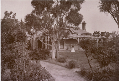
Photograph - B/W Photograph, Louisa Morton at home, C.1880
House on the corner of Blackburn Road and Gordon Crescent Blackburn.Black and white photo of Louisa Mary Esther Morton (c1880), taken at her home on the corner Gordon Crescent and Blackburn Road, Blackburn.morton thomas richards burrowes, morton, louisa mary esther -
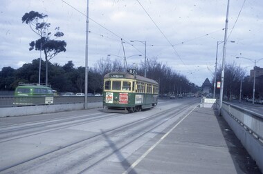
 Melbourne Tram Museum
Photograph - Cable Tram 266 Brighton Road - conversion, c1926
Photograph shows a cable tram set in St Kilda Road, during the conversion of St Kilda Road to electric trams. Trailer No. 266. Near Mowbray St, late 1925 or early 1926.Yields information about the conversion of St Kilda Road.Black and white photograph with notes on the rear.On rear in pencil "M&MTB cable & 266 trailer, scene shows laying of electric tram lines about 1925 or 1926. Brighton Road bound in St Kilda Road, near Mowbray Street." and Ken Magor stamp No. 19 Has the number "165" in pencil in top right-hand corner. tramways, cable trams, conversion, st kilda road, tram 266 -
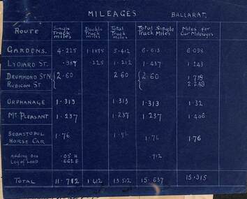 Ballarat Tramway Museum
Document - Report, Electric Supply Co. of Vic (ESCo), "Mileages Ballarat", "Fare Distances", c1920?
Yields information about track mileages and horse tram track and information used in calculating fares.Report or chart - set of two documents pinned together in the top left hand corner giving information of system miles for both track and fares. .1 - Blue print - Mileages Ballarat - giving route including Sebastopol Horse car and one leg of a loop. Provides single track miles, double track miles, Total track, Total Single track miles, miles for car mileages. .2 - "Fares Distances" dated 7-3-01 - all routes. Has been prepared on the rear of a 1921 calendar, Brown, Win? of 30 Armstrong St Ballarat.trams, tramways, mileage, horse trams, esco, fares, crossing loop -
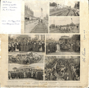 Kew Historical Society Inc
Article, The New Electric Tramway, Malvern to Kew
One of a group of photographs, including three within a published photo collage , taken by Edgar James Dower in the second decade of the twentieth century. Born and raised in Olinda, Dower later moved to Surrey Hills. He worked as an adult as a clerk in the city office of the Metropolitan Gas Company, and in his role as a 'collector', he was able to photograph scenes including the construction of tramlines, railways and associated buildings in Kew, Hawthorn, Camberwell and Surrey Hills. Later he established a real estate agency with his brother - the E.J. Dower Real Estate Agency, Mount Dandenong Office.The photo collage is an historically significant record of the development of transport infrastructure which was used to connect Victorians in the first two decades of the twentieth century. This development resulted from increases in population and the consequent extension of Melbourne's suburbs. The photographs, both individually and collectively, richly detail the labour of workers and the tools and machinery used to create and extend Melbourne's public transport network in the years preceding and during World War 1.Photo collage, published in The Leader newspaper in 1913, to commemorate the opening of the Malvern to Kew Tramway. The numbered photos are: 1. Kew Railway Gates at Glenferrie. 2. Burke Road Terminus. 3. Final Stages. 4. Ladies at the Official Opening. 5. The Acting Mayoress of Kew Cutting the Ribbon at the Kew Boundary. 6. Mayor and Councillors at the Kew Terminus. 7. The Cutting the First Ribbon. 8. Guests at the Hawthorn Town Hall.Inscribed in ink by Edgar J Dower top left: "The 3 top photographs were taken by E J Dower. No.3 Cotham Road Kew near Glenferrie Road"theme -- connecting victorians by transport and communications, theme -- travelling by tram -
 Melbourne Tram Museum
Slide, Peter Moses, Sep. 1973
Photograph of W6 958 on a Carnegie Route 67 Service leaving the tram stop at the south end of Princes Bridge, over Jeffries Parade, St Kilda Road 1973, probably 9/73. Slide Dated Oct. 73. Has the Shrine of Remembrance in the view. Tram has advertisements for Roh Wild wheels, Williams & Co. Real Estate Agents. Kodak cardboard mount slide, taken by Peter Moses.In ink on slide "1973 St kilda Road, Tram stop with Underpass.trams, tramways, w6 class, st kilda rd, princes bridge, route 67, carnegie, tram 958 -
 Melbourne Tram Museum
Photograph - Digital Image, Kevin O'Reilly, St Kilda looking east over St Kilda Junction, late 1925
Image from CD (Compact Diskette for use in computers) - see Reg Item 135. Image titled "St Kilda" on CD, of looking east over St Kilda Junction from. Has St Kilda tramway Jtn (St Kilda Road, Fitzroy St, Barkly St, Brighton Road, Wellington St and Punt Road in the photograph, and the "Junction Oval". Mid to late 1925 as workmen are converting the cable track in Fitzroy St and Wellington St looks or appears converted with a crossover installed near the junction. Two cable car sets visible in St Kilda Road, on in Brighton Road and a bus? Also a bus? in Fitzroy St.trams, tramways, st kilda junction, st kilda railway station, fitzroy st, brighton rd, cable trams -
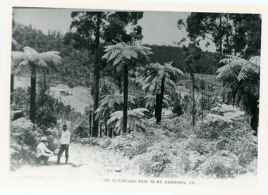 Mt Dandenong & District Historical Society Inc.
Photograph, View From Doughty's Road 1913
Mt Calvin, the homestead of Jeanie and Willie Richardson can be clearly seen in the clearing above the men in the picture. The white roof of the Barber homestead is on the right of the picture. A landslide in 1934 destroyed the tree ferned area. John Lundy-Clarke grew up in the Kalorama/Mt Dandenong area and later in life (1972-74) began to write a comprehensive history of the area working from an original settlement map in an effort to cover all areas.Black and white photograph that is a copy of a Rose series postcard titled 'The Picturesque Road to Mt. Dandenong. Vic.' It shows two men (probably Rose Series employees), one sitting and one standing at the edge of an unmade road. Large tree ferns line the roadside. Handwritten inscription on reverse by John Lundy-Clarke1913 View east from Doughty’s Road showing Jeannie Richardson’s home through the gap in the trees. A little to the right of and below centre of picture can be seen George Barber’s home with Barbers Road turning around the wagon shed that was a little up the hill from the house. The tree ferns in the picture were destroyed in the landslide of 1934. In the distance at the right can be seen F.M. Childs Homestead complex with the Richardson paddocks beyond it.mt calvin, jeanie richardson, willie richardson, george barber, landslide, tree fern -
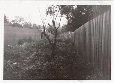 Kew Historical Society Inc
Photograph - Right-of-way at rear of Parkhill Road and Lalla Street, 1973
One of a series of photographs donated by the City Engineer of the former City of Kew, relating to road works and rubbish removal.One of a series of photographs of core local government services as practised by the City of Kew. The photographs are an accurate record of council works of the period.Original black and white photographic an overgrown right-of-way at the rear of properties in Parkhill Road and Lalla Street, Kew"ROW AT REAR OF PROPERTIES / PARKHILL RD / LALLA ST / JULY '73"city of kew, local government -- city of kew, council works, street maintenance, right-of-ways, lanes