Showing 2013 items matching "war and society - australia"
-
 Kew Historical Society Inc
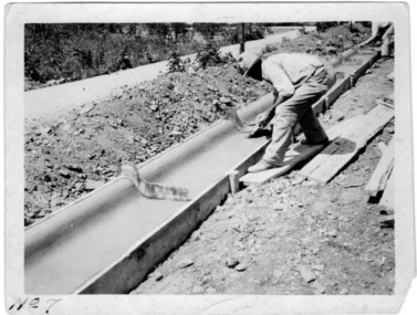
Photograph - Instructional photograph No.7: Using concrete for street kerbs, Portland Cement Association, 1921
One of seven photographs produced by the Portland Cement Association in 1921 showing how concrete kerbs could be created. Portland Cement Association (PCA) was founded in 1916. From 1917, the association actively promoted the benefits of concrete for road works in Australian newspapers. In the nineteenth century in Melbourne (Vic.) 'made roads' typically had gutters and kerbing lined with bluestone.The photographs are important evidence of the availability of instructional models for the use of concrete in street works in Victoria. While the photographs date from the early 1920s, the use of concrete for kerbing did not reach its maturity until after World War 2. The photos demonstrate knowledge about and the use of concrete in street works in a major Melbourne municipality at an early period.Black and white photograph with printed instructions on the reverse showing the production of concrete kerbing on 67th Street, West Allis, Milwaukee, Wisconsin (USA). The photograph was produced by the Portland Cement Association of Chicago in 1921 and used within the Chief Engineer's Department of the City of Kew (Vic.)."7th - Brushing Surface with flat brush, wet with clean water, to remove tool marks and small surface irregularities." street works, kerbing, gutters, concrete, portland cement association -
 Kew Historical Society Inc
Document, Arnall & Jackson: Printers & Stationers, City of Kew: Air Raid Precautions Organisation, June 1940
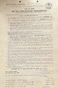
Air Raid Precautions Organisations were formed in each State in Australia during the Second World War. In Victoria they were organised by the State Emergency Council (Victoria) for Civil Defence. In Melbourne, the organisations were locally based in municipalities. Within a municipality, areas were organised into sectors.Twelve point instructions distributed by the District Warden's Office, Town Hall, Kew in June 1940 and issued by the authority and with the approval of the Kew City Council, W. D. Birrell (Town Clerk), outlining advice for residents in the event of an air raid. City of Kew seal at top right. The document was issued to residents in Sector 9. It was printed by Arnall & Jackson, 115 Barkly Street, W. Brunswick.Signed [Sector Warden] F. J. [sic] Warry, 65 Molesworth Street; [Senior Warden] K. L. Robertssecond world war, city of kew, wwii, air raid precautions organisation -
 Kew Historical Society Inc
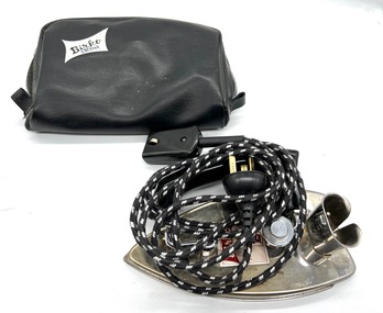
Equipment - Travel iron, Birko, 1960s
Birko is an Australian brand, manufacturing and retailing appliances since before the Second World War.Birko travel iron with its original electrical fittings and vinyl case.Birko iron birko, travel irons -
 Birregurra Historical Society
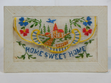
Postcard, C1917
World War 1 1917 embroidered postcard from nephew of Jim Purcell to his aunt and uncle.Embroidered post card from 1917 WW1 'Home Sweet Home'. Additional small Christmas card included in an inside pocket.To Mr John Purcell / Clearview / Birregurra / Victoria / Australia All well from your ever loving nep (sic) (nephew) Christmas card reads A Merry Xmas to all Jim postcard, world war 1, birregurra -
 Kew Historical Society Inc
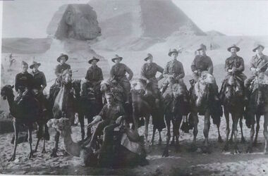
Photograph - Photograph [copy], Australian soldiers in Egypt, 1914, 1914
Charles Field Richardson was the brother of Kew historian Dorothy Rogers. He died at Alexandria after being wounded at Gallipoli. This work forms part of the collection assembled by the historian Dorothy Rogers, that was donated to the Kew Historical Society by her son John Rogers in 2015. The manuscripts, photographs, maps, and documents were sourced by her from both family and local collections or produced as references for her print publications. Many were directly used by Rogers in writing ‘Lovely Old Homes of Kew’ (1961) and 'A History of Kew' (1973), or the numerous articles on local history that she produced for suburban newspapers. Most of the photographs in the collection include detailed annotations in her hand.The Rogers Collection provides a comprehensive insight into the working habits of a historian in the 1960s and 1970s. Together it forms the largest privately-donated collection within the archives of the Kew Historical Society.Australian soldiers at the pyramids of Egypt before departure for Gallipoli. One of them is Charles Field Richardson, Regimental Number 341, 6th Battalion, Australian Imperial Forces. Charles Richardson far leftcharles field richardson, dorothy rogers, world war 1, australian soldiers, egypt, pyramids, sphinx, gallipoli, charles richardson, camel -
 Kew Historical Society Inc
Plan, Studley Heights Estate, 1936
Pru Sanderson, in her groundbreaking ‘City of Kew Urban Conservation Study : Volume 2 - Development History’ (1988), summarised the periods of urban development and subdivisions of land in Kew. The periods that she identified included 1845-1880, 1880-1893, 1893-1921, 1921-1933, 1933-1943, and Post-War Development. These periods were selected as they represented periods of rapid growth or decline in urban development. An obvious starting point for Sanderson’s groupings involved population growth and the associated economic cycles. These cycles also highlighted urban expansion onto land that was predominantly rural, although in other cases it represented the decline and breakup of large estates. A number of the plans in the Kew Historical Society’s collection can also be found in other collections, such as those of the State Library of Victoria and the Boroondara Library Service. A number are however unique to the collection.Subdivision plans are historically important documents used as evidence of the growth of suburbs in Australia. They frequently provide information about when the land was sold on which a built structure was subsequently constructed as well as evidence relating to surveyors and real estate and financial agents. The numerous subdivision plans in the Kew Historical Society's collection represent working documents, ranging from the initial sketches made in planning a subdivision to printed plans on which auctioneers or agents listed the prices for which individual lots were sold. In a number of cases, the reverse of a subdivision plan in the collection includes a photograph of a house that was also for sale by the agent. These photographs provide significant heritage information relating house design and decoration, fencing and household gardens.The ‘Studley Heights Estate’ on the South Side of Studley Park Road was launched in 1936. The seventeen allotments in the subdivision fronted Hyton Crescent and Studley Park Road.subdivision plans - kew, studley heights estate -
![Monnington [Estate], 1935](/media/collectors/550653872162f11fb04854aa/items/5907eb86d0ce0c14e82385c8/item-media/5907ecafd0ce0c14e823e87f/item-fit-380x285.jpg) Kew Historical Society Inc
Kew Historical Society IncPlan - Subdivision Plan, Monnington [Estate], 1935, 1935
Pru Sanderson, in her groundbreaking ‘City of Kew Urban Conservation Study : Volume 2 - Development History’ (1988), summarised the periods of urban development and subdivisions of land in Kew. The periods that she identified included 1845-1880, 1880-1893, 1893-1921, 1921-1933, 1933-1943, and Post-War Development. These periods were selected as they represented periods of rapid growth or decline in urban development. An obvious starting point for Sanderson’s groupings involved population growth and the associated economic cycles. These cycles also highlighted urban expansion onto land that was predominantly rural, although in other cases it represented the decline and breakup of large estates. A number of the plans in the Kew Historical Society’s collection can also be found in other collections, such as those of the State Library of Victoria and the Boroondara Library Service. A number are however unique to the collection.Subdivision plans are historically important documents used as evidence of the growth of suburbs in Australia. They frequently provide information about when the land was sold on which a built structure was subsequently constructed as well as evidence relating to surveyors and real estate and financial agents. The numerous subdivision plans in the Kew Historical Society's collection represent working documents, ranging from the initial sketches made in planning a subdivision to printed plans on which auctioneers or agents listed the prices for which individual lots were sold. In a number of cases, the reverse of a subdivision plan in the collection includes a photograph of a house that was also for sale by the agent. These photographs provide significant heritage information relating house design and decoration, fencing and household gardens.The first subdivision of Monnington took place in 1935. At that time, Monnington and 10 new allotments were offered for sale bordering Adeney and Marshall Avenues. In this subdivision plan, Monnington is one of 13 lots for sale. The subdivision created the irregular land holding of Monnington today. The excision of southwest corner of Monninton was caused by the need to have regular allotments facing the curve in Marshall Avenue.monnington - adeney avenue -- kew (vic.), subdivision plans -- kew (vic.) -
 Kew Historical Society Inc
Plan - Subdivision Plan, Wimba Estate, Kew, c.1925-c.1929, ca. 1925-ca. 1929
Pru Sanderson, in her groundbreaking ‘City of Kew Urban Conservation Study : Volume 2 - Development History’ (1988), summarised the periods of urban development and subdivisions of land in Kew. The periods that she identified included 1845-1880, 1880-1893, 1893-1921, 1921-1933, 1933-1943, and Post-War Development. These periods were selected as they represented periods of rapid growth or decline in urban development. An obvious starting point for Sanderson’s groupings involved population growth and the associated economic cycles. These cycles also highlighted urban expansion onto land that was predominantly rural, although in other cases it represented the decline and breakup of large estates. A number of the plans in the Kew Historical Society’s collection can also be found in other collections, such as those of the State Library of Victoria and the Boroondara Library Service. A number are however unique to the collection.Subdivision plans are historically important documents used as evidence of the growth of suburbs in Australia. They frequently provide information about when the land was sold on which a built structure was subsequently constructed as well as evidence relating to surveyors and real estate and financial agents. The numerous subdivision plans in the Kew Historical Society's collection represent working documents, ranging from the initial sketches made in planning a subdivision to printed plans on which auctioneers or agents listed the prices for which individual lots were sold. In a number of cases, the reverse of a subdivision plan in the collection includes a photograph of a house that was also for sale by the agent. These photographs provide significant heritage information relating house design and decoration, fencing and household gardens.In 1925, the City of Kew called for tenders for the construction of Wimba Avenue, Cadow Street and Lalla Street. Subsequent advertisements for the sale of land in Wimba Avenue continued from 1926 to 1929. The 18 lots (and a further five allotments on the eastern side of the street) offered for sale were unofficially described in the subdivision plan as the ‘Wimba Estate’. These lots began in Park Hill Road and extended almost to Cotham Road. The subdivision took its name from the house ‘Wimba’ in Cotham Road, which may have formed the southern boundary of the subdivision. (Wimba, at 235 Cotham Road was constructed between 1862-70). The Plan highlights the proximity and advantage of ‘electric’ trams in Cotham and Glenferrie Roads, and the Kew and Glenferrie Railway Stations. An oddity in the Plan is the reference to the electric tram terminus at Burke Road, given that the tramline had already been extended to Mont Albert in 1916.wimba estate, subdivision plans - kew, parkhill road – kew (vic.), normanby road – kew (vic.), wimba avenue – kew (vic.) -
 Kew Historical Society Inc
Plan, F R Simms & Son, Land for Private Sale: Cnr Victor Avenue and Mont Victor Road, Kew, 1950-1960
George Rimington established The Parkhill Nursery in 1877. By 1910, it was more commonly known as Rimington’s Nurseries and well known for its sale of violets. After World War II, Rimington’s Nurseries were gradually subdivided and sold. The 38 allotments were released in sections, including lots 34 to 36 on the corner of Mont Victor Road and Victor Avenue. Previous lots in the subdivision had bordered Burke Road, Rimington Avenue, Heather Grove, and Stoke Avenue. The selling point as it had been in comparable estates for a century were the proximity to transport, schools and churches, as well as the high location and excellent views. The subdivision plan shows most of the lots in the entire subdivision: 1-11, 13-26, and 34-38. Presumably, lot 12 and lots 27-33 were still to be released.Subdivision plans are historically important documents used as evidence of the growth of suburbs in Australia. They frequently provide information about when the land was sold on which a built structure was subsequently constructed as well as evidence relating to surveyors and real estate and financial agents. The numerous subdivision plans in the Kew Historical Society's collection represent working documents, ranging from the initial sketches made in planning a subdivision to printed plans on which auctioneers or agents listed the prices for which individual lots were sold. In a number of cases, the reverse of a subdivision plan in the collection includes a photograph of a house that was also for sale by the agent. These photographs provide significant heritage information relating house design and decoration, fencing and household gardens.Subdivision plan advertising five superb home sites among lots in Burke Road, Stoke Avenue, Victor Avenue, Mont Victor Road and Heather Grove.subdivision plans - kew, rimington avenue -- kew (vic.), heather grove -- kew (vic), stoke avenue -- kew (vic.), burke road -- kew (vic.), mont victor road -- kew (vic.) -
 Kew Historical Society Inc
Plan - Subdivision Plan, Eastlawn Estate, 1914
Subdivision plans are historically important documents used as evidence of the growth of suburbs in Australia. They frequently provide information about when the land was sold on which a built structure was subsequently constructed as well as evidence relating to surveyors and real estate and financial agents. The numerous subdivision plans in the Kew Historical Society's collection represent working documents, ranging from the initial sketches made in planning a subdivision to printed plans on which auctioneers or agents listed the prices for which individual lots were sold. In a number of cases, the reverse of a subdivision plan in the collection includes a photograph of a house that was also for sale by the agent. These photographs provide significant heritage information relating house design and decoration, fencing and household gardens.The ‘Eastlawn Estate’ was surveyed and ready for auction in March 1914, three months before the outbreak of World War I. Sixty-six allotments, created on the ‘order of Mr & Miss Preston’ surrounded the mansion of Woodlands in Harp Road. Woodlands formed part of the Estate, being advertised as lot 1. The allotments faced High, Station and Wright Streets, Harp and Normanby Roads, and Woodlands Avenue. Pru Sanderson in the Kew Conservation Study (Vol.2, 1988) wrote that the Eastlawn Estate ‘covered the western half of the failed Harp of Erin Estate’. Contemporary advertisements promoted the Eastlawn Estate as: ‘There will be no more convenient district nor pleasant Suburb than East Kew for the busy business man. When the Electric Tram is laid, he will be able to journey quickly and pleasantly direct from Collins Street to his home in the Eastlawn Estate in about 20 minutes’. The actual plans of subdivision were included in advertisements in The Argus and in the local newspapers.subdivision plans - east kew, eastlawn estate -
 Kew Historical Society Inc
Plan - Subdivision Plan, Oswinia Estate, East Kew, c.1925
Prue Sanderson, in her groundbreaking ‘City of Kew Urban Conservation Study : Volume 2 - Development History’ (1988), summarised the periods of urban development and subdivisions of land in Kew. The periods that she identified included 1845-1880, 1880-1893, 1893-1921, 1921-1933, 1933-1943, and Post-War Development. These periods were selected as they represented periods of rapid growth or decline in urban development. An obvious starting point for Sanderson’s groupings involved population growth and the associated economic cycles. These cycles also highlighted urban expansion onto land that was predominantly rural, although in other cases it represented the decline and breakup of large estates. A number of the plans in the Kew Historical Society’s collection can also be found in other collections, such as those of the State Library of Victoria and the Boroondara Library Service. A number are however unique to the collection.Subdivision plans are historically important documents used as evidence of the growth of suburbs in Australia. They frequently provide information about when the land was sold on which a built structure was subsequently constructed as well as evidence relating to surveyors and real estate and financial agents. The numerous subdivision plans in the Kew Historical Society's collection represent working documents, ranging from the initial sketches made in planning a subdivision to printed plans on which auctioneers or agents listed the prices for which individual lots were sold. In a number of cases, the reverse of a subdivision plan in the collection includes a photograph of a house that was also for sale by the agent. These photographs provide significant heritage information relating house design and decoration, fencing and household gardens.The ‘Oswinia Estate’ subdivision in East Kew was planned and auctioned in the first half of the 1920s. 169 allotments were created in the triangular section of land bordered by High Street, Burke Road and the Government Boulevard (later Kilby Road). The only piece of land excluded was that where the previous Kew Pound had been located at the east tip of the triangle. Allotments were created fronting Glass, High, Namur, Oswin Streets, Irymple Avenue, and the Government Boulevard. The name for the Estate was derived from Oswin’s farm, which had been one of the largest landholdings in East Kew. The selling agents annotated the plan in our collection with crosses indicating those lots that had been sold. The inset locality plan is particularly interesting as it shows the route and stations of the Outer Circle Railway. When the subdivision plan was created, it included the proposed bridge over the Yarra at Burke Road. The bridge was to be officially opened in 1926.subdivision plans - east kew, oswinia estate, high street, glass street, namur street, government boulevard - kilby road, irymple street, oswin street -
 Kew Historical Society Inc
Plan - Subdivision Plan, 6 Choice Residential Allotments: East Kew, 1932
Prue Sanderson, in her groundbreaking ‘City of Kew Urban Conservation Study : Volume 2 - Development History’ (1988), summarised the periods of urban development and subdivisions of land in Kew. The periods that she identified included 1845-1880, 1880-1893, 1893-1921, 1921-1933, 1933-1943, and Post-War Development. These periods were selected as they represented periods of rapid growth or decline in urban development. An obvious starting point for Sanderson’s groupings involved population growth and the associated economic cycles. These cycles also highlighted urban expansion onto land that was predominantly rural, although in other cases it represented the decline and breakup of large estates. A number of the plans in the Kew Historical Society’s collection can also be found in other collections, such as those of the State Library of Victoria and the Boroondara Library Service. A number are however unique to the collection.Subdivision plans are historically important documents used as evidence of the growth of suburbs in Australia. They frequently provide information about when the land was sold on which a built structure was subsequently constructed as well as evidence relating to surveyors and real estate and financial agents. The numerous subdivision plans in the Kew Historical Society's collection represent working documents, ranging from the initial sketches made in planning a subdivision to printed plans on which auctioneers or agents listed the prices for which individual lots were sold. In a number of cases, the reverse of a subdivision plan in the collection includes a photograph of a house that was also for sale by the agent. These photographs provide significant heritage information relating house design and decoration, fencing and household gardens.The mansion Woodlands in Harp Road, East Kew suffered the death of a thousand cuts. In its case, the cuts were subdivisions. Previous subdivisions of the mansion and its grounds were given titles such as ‘The Eastlawn Estate’ (MAP.0055), whereas at the end, the subdivision called it as it was, naming itself the ‘final section of the Woodlands Estate’ when it was put up for auction in 1932. The emphasis in the promotion of the subdivision was that it provided purchasers with splendid opportunities ‘to build modern homes in select, well established modern surroundings’. As with other subdivisions in the interwar period, transport links were emphasised. The six residential lots cut Woodlands off from Harp Road. When the vendor, Louisa Rachel Preston Hill, was to die at Woodlands in 1937 aged 86 her address was given as Normanby Road.subdivision plans - kew, woodlands estate -
 Kew Historical Society Inc
Plan, J R Mathers & McMillan, 5 Splendid vVlla Allotments,: Segtoune St. & Windsor St., Kew, 1928
Prue Sanderson, in her groundbreaking ‘City of Kew Urban Conservation Study : Volume 2 - Development History’ (1988), summarised the periods of urban development and subdivisions of land in Kew. The periods that she identified included 1845-1880, 1880-1893, 1893-1921, 1921-1933, 1933-1943, and Post-War Development. These periods were selected as they represented periods of rapid growth or decline in urban development. An obvious starting point for Sanderson’s groupings involved population growth and the associated economic cycles. These cycles also highlighted urban expansion onto land that was predominantly rural, although in other cases it represented the decline and breakup of large estates. A number of the plans in the Kew Historical Society’s collection can also be found in other collections, such as those of the State Library of Victoria and the Boroondara Library Service. A number are however unique to the collection.Subdivision plans are historically important documents used as evidence of the growth of suburbs in Australia. They frequently provide information about when the land was sold on which a built structure was subsequently constructed as well as evidence relating to surveyors and real estate and financial agents. The numerous subdivision plans in the Kew Historical Society's collection represent working documents, ranging from the initial sketches made in planning a subdivision to printed plans on which auctioneers or agents listed the prices for which individual lots were sold. In a number of cases, the reverse of a subdivision plan in the collection includes a photograph of a house that was also for sale by the agent. These photographs provide significant heritage information relating house design and decoration, fencing and household gardens.In 1928, five residential allotments bordering Segtoune and Windsor Streets were advertised for sale as part of a subdivision. Four of the blocks faced Segtoune Avenue. The auctioneers proclaimed the advantages of the sites: ‘Situate one minute from the High Street Electric Tram, which now runs direct to Spencer Street via Bridge Road and Flinders Street. Opposite the East Kew Railway Station (Outer Circle Line), which may be reopened In connection with the new Line from Kew to Doncaster; Adjacent lo the Kew Recreation Reserve, Sports Oval, and Swimming Bath; Half Minute from the Shopping Centre of East Kew, Accessible to the State School and Other Educational Centres’. The Harp of Erin Hotel and the route of the Outer Circle Railway line are marked on the plan. The Recreation Reserve and Sport Oval refer to Victoria Park. The Swimming Baths were located on the site of the current Kew Recreation Centre.subdivision plans - kew, segtoune street -- kew (vic.), windsor street -- kew (vic.) -
 Kew Historical Society Inc
Plan - Subdivision Plan, Plan of Subdivision of Crown Portion 71, Parish of Boroondara LP12509, Vol.1678, Fol.335526, Before 1930
Prue Sanderson, in her groundbreaking ‘City of Kew Urban Conservation Study : Volume 2 - Development History’ (1988), summarised the periods of urban development and subdivisions of land in Kew. The periods that she identified included 1845-1880, 1880-1893, 1893-1921, 1921-1933, 1933-1943, and Post-War Development. These periods were selected as they represented periods of rapid growth or decline in urban development. An obvious starting point for Sanderson’s groupings involved population growth and the associated economic cycles. These cycles also highlighted urban expansion onto land that was predominantly rural, although in other cases it represented the decline and breakup of large estates. A number of the plans in the Kew Historical Society’s collection can also be found in other collections, such as those of the State Library of Victoria and the Boroondara Library Service. A number are however unique to the collection.Subdivision plans are historically important documents used as evidence of the growth of suburbs in Australia. They frequently provide information about when the land was sold on which a built structure was subsequently constructed as well as evidence relating to surveyors and real estate and financial agents. The numerous subdivision plans in the Kew Historical Society's collection represent working documents, ranging from the initial sketches made in planning a subdivision to printed plans on which auctioneers or agents listed the prices for which individual lots were sold. In a number of cases, the reverse of a subdivision plan in the collection includes a photograph of a house that was also for sale by the agent. These photographs provide significant heritage information relating house design and decoration, fencing and household gardens.The six lots on the south side of Macartney Avenue, between Macartney Avenue and Daniell Place were part of a subdivision that occurred before 1930. The subdivision plan is of interest in that the original name of Daniell Place was Brougham Place. On the Plan, it is noted that lots 5 and 6 (currently 10 and 12 Macartney Avenue) had been sold for £13 each. By November 1930, the new six-roomed villa built on 12 Macartney Avenue was offered for immediate sale at a ‘sacrifice price’. Any offer in reason would be considered, although a £350 deposit was required.subdivision plans - kew, mount street - kew, brougham street - kew , macartney avenue - kew -
 Kew Historical Society Inc
Plan - Subdivision Plan, Mont Victor Hill Estate, 1936
Pru Sanderson, in her groundbreaking ‘City of Kew Urban Conservation Study : Volume 2 - Development History’ (1988), summarised the periods of urban development and subdivisions of land in Kew. The periods that she identified included 1845-1880, 1880-1893, 1893-1921, 1921-1933, 1933-1943, and Post-War Development. These periods were selected as they represented periods of rapid growth or decline in urban development. An obvious starting point for Sanderson’s groupings involved population growth and the associated economic cycles. These cycles also highlighted urban expansion onto land that was predominantly rural, although in other cases it represented the decline and breakup of large estates. A number of the plans in the Kew Historical Society’s collection can also be found in other collections, such as those of the State Library of Victoria and the Boroondara Library Service. A number are however unique to the collection.Subdivision plans are historically important documents used as evidence of the growth of suburbs in Australia. They frequently provide information about when the land was sold on which a built structure was subsequently constructed as well as evidence relating to surveyors and real estate and financial agents. The numerous subdivision plans in the Kew Historical Society's collection represent working documents, ranging from the initial sketches made in planning a subdivision to printed plans on which auctioneers or agents listed the prices for which individual lots were sold. In a number of cases, the reverse of a subdivision plan in the collection includes a photograph of a house that was also for sale by the agent. These photographs provide significant heritage information relating house design and decoration, fencing and household gardens.A preliminary plan for the Mont Victor Hill subdivision of 1936 which included 23 allotments bordering the Rimington Nursery in Mont Victor Road. The subdivision created allotments in Victor Avenue, Heather Grove and Burke Road. Bisecting the Estate and clearly marked on the plan is the Railway Reserve which at this stage was all that remained of the Outer Circle Railway. The auctioneers note on the plan that the subdivision was made possible by the order of Messrs S. H. Bennet & H. Wright, the executors of the Wills of S. Bennett & E. Foreman.mont victor hill estate, subdivision plans - kew -
 Kew Historical Society Inc
Plan - Subdivision Plan, Tregarron Estate, Kew, c.1929
Pru Sanderson, in her groundbreaking ‘City of Kew Urban Conservation Study : Volume 2 - Development History’ (1988), summarised the periods of urban development and subdivisions of land in Kew. The periods that she identified included 1845-1880, 1880-1893, 1893-1921, 1921-1933, 1933-1943, and Post-War Development. These periods were selected as they represented periods of rapid growth or decline in urban development. An obvious starting point for Sanderson’s groupings involved population growth and the associated economic cycles. These cycles also highlighted urban expansion onto land that was predominantly rural, although in other cases it represented the decline and breakup of large estates. A number of the plans in the Kew Historical Society’s collection can also be found in other collections, such as those of the State Library of Victoria and the Boroondara Library Service. A number are however unique to the collection.Subdivision plans are historically important documents used as evidence of the growth of suburbs in Australia. They frequently provide information about when the land was sold on which a built structure was subsequently constructed as well as evidence relating to surveyors and real estate and financial agents. The numerous subdivision plans in the Kew Historical Society's collection represent working documents, ranging from the initial sketches made in planning a subdivision to printed plans on which auctioneers or agents listed the prices for which individual lots were sold. In a number of cases, the reverse of a subdivision plan in the collection includes a photograph of a house that was also for sale by the agent. These photographs provide significant heritage information relating house design and decoration, fencing and household gardens.In January 1929, the Kew City Council called for tenders to construct Tregarron Avenue. The subdivision of the Tregarron Estate in Kew was for 11 lots bordering Tregarron Avenue and its entrance from Burke Road. The plan includes annotations that indicate the measurement of each block and the placement of the drainage and sewerage easements. This plan is interesting for a number of factors. The house blocks today have different street numbers, some blocks were to be further subdivided, and at the time of the subdivision, alterations were still being made to the extent of lots offered; lots 2 and 3 on the plan were subdivided and reoriented.subdivision plans - kew, tregarron estate, tregarron avenue -- kew (vic.), burke road -- kew (vic.) -
 Kew Historical Society Inc
Map - Subdivision Plan, Grenville Estate, 1922
Pru Sanderson, in her groundbreaking ‘City of Kew Urban Conservation Study : Volume 2 - Development History’ (1988), summarised the periods of urban development and subdivisions of land in Kew. The periods that she identified included 1845-1880, 1880-1893, 1893-1921, 1921-1933, 1933-1943, and Post-War Development. These periods were selected as they represented periods of rapid growth or decline in urban development. An obvious starting point for Sanderson’s groupings involved population growth and the associated economic cycles. These cycles also highlighted urban expansion onto land that was predominantly rural, although in other cases it represented the decline and breakup of large estates. A number of the plans in the Kew Historical Society’s collection can also be found in other collections, such as those of the State Library of Victoria and the Boroondara Library Service. A number are however unique to the collection.Subdivision plans are historically important documents used as evidence of the growth of suburbs in Australia. They frequently provide information about when the land was sold on which a built structure was subsequently constructed as well as evidence relating to surveyors and real estate and financial agents. The numerous subdivision plans in the Kew Historical Society's collection represent working documents, ranging from the initial sketches made in planning a subdivision to printed plans on which auctioneers or agents listed the prices for which individual lots were sold. In a number of cases, the reverse of a subdivision plan in the collection includes a photograph of a house that was also for sale by the agent. These photographs provide significant heritage information relating house design and decoration, fencing and household gardens.In advertising the twenty-two sites of the Grenville Estate in Cotham Road and Alfred Street, Kew, the auctioneers emphasised the proximity of the development to shops, schools, and churches. That mansions surrounded the Estate was publicised as an added attraction. The plan shows how at this stage A regrettable aspect of this plan is that it is pasted over, and obscures a real estate photograph by the Kew photographer Josiah Earl Barnes.subdivision plans - kew, grenville estate, glenferrie road, alfred street, thomas street, cotham road -
 Kew Historical Society Inc
Plan - Subdivision Plan, Forres Estate, East Kew, 1919, 1919
Pru Sanderson, in her groundbreaking ‘City of Kew Urban Conservation Study : Volume 2 - Development History’ (1988), summarised the periods of urban development and subdivisions of land in Kew. The periods that she identified included 1845-1880, 1880-1893, 1893-1921, 1921-1933, 1933-1943, and Post-War Development. These periods were selected as they represented periods of rapid growth or decline in urban development. An obvious starting point for Sanderson’s groupings involved population growth and the associated economic cycles. These cycles also highlighted urban expansion onto land that was predominantly rural, although in other cases it represented the decline and breakup of large estates. A number of the plans in the Kew Historical Society’s collection can also be found in other collections, such as those of the State Library of Victoria and the Boroondara Library Service. A number are however unique to the collection.Subdivision plans are historically important documents used as evidence of the growth of suburbs in Australia. They frequently provide information about when the land was sold on which a built structure was subsequently constructed as well as evidence relating to surveyors and real estate and financial agents. The numerous subdivision plans in the Kew Historical Society's collection represent working documents, ranging from the initial sketches made in planning a subdivision to printed plans on which auctioneers or agents listed the prices for which individual lots were sold. In a number of cases, the reverse of a subdivision plan in the collection includes a photograph of a house that was also for sale by the agent. These photographs provide significant heritage information relating house design and decoration, fencing and household gardens.An annotated subdivision plan for the Forres Estate, Kew East. The estate was advertised in 1919, the Melbourne Auctioneers being represented locally by Henry Kellett, Estate Agent of High Street, Kew. The name of the estate was derived from the mansion (demolished 2016) of the same name in Normanby Road, which was at one stage owned by the Mayor of Kew, Cr. J. S. Were.subdivision plans - kew, forres estate, argyle road, simpson street, hubert street, normanby road -
 Kew Historical Society Inc
Plan - Subdivision Plan, St Helliers Estate, Kew, circa 1910, c.1910
Pru Sanderson, in her groundbreaking ‘City of Kew Urban Conservation Study : Volume 2 - Development History’ (1988), summarised the periods of urban development and subdivisions of land in Kew. The periods that she identified included 1845-1880, 1880-1893, 1893-1921, 1921-1933, 1933-1943, and Post-War Development. These periods were selected as they represented periods of rapid growth or decline in urban development. An obvious starting point for Sanderson’s groupings involved population growth and the associated economic cycles. These cycles also highlighted urban expansion onto land that was predominantly rural, although in other cases it represented the decline and breakup of large estates. A number of the plans in the Kew Historical Society’s collection can also be found in other collections, such as those of the State Library of Victoria and the Boroondara Library Service. A number are however unique to the collection.Subdivision plans are historically important documents used as evidence of the growth of suburbs in Australia. They frequently provide information about when the land was sold on which a built structure was subsequently constructed as well as evidence relating to surveyors and real estate and financial agents. The numerous subdivision plans in the Kew Historical Society's collection represent working documents, ranging from the initial sketches made in planning a subdivision to printed plans on which auctioneers or agents listed the prices for which individual lots were sold. In a number of cases, the reverse of a subdivision plan in the collection includes a photograph of a house that was also for sale by the agent. These photographs provide significant heritage information relating house design and decoration, fencing and household gardens.In the subdivision of part of Crown Portion 82, bordered by John and Sackville Streets and Cotham and Burke Roads, over 100 lots were offered for sale. In addition to the designated lots, a number of key locations are also identified. These include the Genazzano Convent to the north of Cotham Road, the Reservoir, St Hilary’s and the land holding of Colonel Parnell on the corner of John Street and Cotham Road. On the Plan, No. 5064, is the handwritten name ‘St. Hellier’s Estate’. St. Helliers, the home of the Dumaresq family is shown beside St. Hilary’s.subdivision plans - kew, st helliers estate -
 Kew Historical Society Inc
Plan - Subdivision Plan, Jas R Mathers Son & McMillan, Macartney Estate, East Kew, c. 1925
Pru Sanderson, in her groundbreaking ‘City of Kew Urban Conservation Study : Volume 2 - Development History’ (1988), summarised the periods of urban development and subdivisions of land in Kew. The periods that she identified included 1845-1880, 1880-1893, 1893-1921, 1921-1933, 1933-1943, and Post-War Development. These periods were selected as they represented periods of rapid growth or decline in urban development. An obvious starting point for Sanderson’s groupings involved population growth and the associated economic cycles. These cycles also highlighted urban expansion onto land that was predominantly rural, although in other cases it represented the decline and breakup of large estates. A number of the plans in the Kew Historical Society’s collection can also be found in other collections, such as those of the State Library of Victoria and the Boroondara Library Service. A number are however unique to the collection.Subdivision plans are historically important documents used as evidence of the growth of suburbs in Australia. They frequently provide information about when the land was sold on which a built structure was subsequently constructed as well as evidence relating to surveyors and real estate and financial agents. The numerous subdivision plans in the Kew Historical Society's collection represent working documents, ranging from the initial sketches made in planning a subdivision to printed plans on which auctioneers or agents listed the prices for which individual lots were sold. In a number of cases, the reverse of a subdivision plan in the collection includes a photograph of a house that was also for sale by the agent. These photographs provide significant heritage information relating house design and decoration, fencing and household gardens.The Macartney Estate subdivision advertised 21 lots for sale on either side of Macartney Street (now Macartney Avenue) and Evans Road in what was then designated as East Kew. Most of the houses shown on the south side of Macartney Street then, as now, have rear entrances on Mount Street, however a number of these blocks have since been further subdivided to allow for the building of new houses on the rear of a block. Brougham Place is marked on the plan but is now called Daniell Place."C"subdivision plans - east kew, macartney estate, macartney street, mount street, evans road, brougham place -
 Kew Historical Society Inc
Plan - Subdivision Plan, Jas R Mathers Son & McMillan, The Dale Estate, Deepdene, 1918
Pru Sanderson, in her groundbreaking ‘City of Kew Urban Conservation Study : Volume 2 - Development History’ (1988), summarised the periods of urban development and subdivisions of land in Kew. The periods that she identified included 1845-1880, 1880-1893, 1893-1921, 1921-1933, 1933-1943, and Post-War Development. These periods were selected as they represented periods of rapid growth or decline in urban development. An obvious starting point for Sanderson’s groupings involved population growth and the associated economic cycles. These cycles also highlighted urban expansion onto land that was predominantly rural, although in other cases it represented the decline and breakup of large estates. A number of the plans in the Kew Historical Society’s collection can also be found in other collections, such as those of the State Library of Victoria and the Boroondara Library Service. A number are however unique to the collection.The Kew Historical Society collection includes almost 100 subdivision plans pertaining to suburbs of the City of Melbourne. Most of these are of Kew, Kew East or Studley Park, although a smaller number are plans of Camberwell, Deepdene, Balwyn and Hawthorn. It is believed that the majority of the plans were gifted to the Society by persons connected with the real estate firm - J. R. Mathers and McMillan, 136 Cotham Road, Kew. The Plans in the collection are rarely in pristine form, being working plans on which the agent would write notes and record lots sold and the prices of these. The subdivision plans are historically significant examples of the growth of urban Melbourne from the beginning of the 20th Century up until the 1980s. A number of the plans are double-sided and often include a photograph on the reverse. A number of the latter are by noted photographers such as J.E. Barnes.The Dale Estate in Deepdene was made possible by the death of Robert Sparrow Smythe, Australian journalist, newspaper editor/owner and theatrical manager. Smythe lived in his residence ‘Highate’, Deepdene until his death in 1917. In the subdivision proposed one year later, before the end of the First World War, 18 allotments were to be created. The very fragmentary plan in the Society’s collection notes that a large weatherboard [house] will need to be removed. This may be Smythe’s own home. The proposed subdivision included allotments facing Burke and Whitehorse Roads and Dale Street. Bordering the subdivision is the Deepdene Station and the Outer Circle Railway Line. The clear directions on the plan indicate that in 1918 it was possible to travel by train from Deepdene to East Camberwell and Ashburtonsubdivision plans - deepdene, the dale estate -
 Kew Historical Society Inc
Clothing - Black lace evening dress, 1930s
Doris Mercy Willmott was born in May 1896 in Stamford Hill, London, the eldest of three daughters of Albert and Minnie Willmott. The family lived in various parts of north London until the beginning of the First World War, when they moved to Redhill in Surrey. It was in Redhill that Doris met her future husband, Frederick John (Jack) Bennett. Jack had met Eric Mercy, a cousin of Minnie’s, in the Australian Imperial Force (AIF) and visited the Wilmotts with him whilst on leave from France. Although Jack Bennett returned to Melbourne in March 1919, he and Doris continued to correspond and they were engaged in March 1923. She came to Melbourne on her own, and was married in the Congregational Church in Canterbury on 23 December 1923. By 1931 Doris and Jack and their three sons - John Willmott, Winfield Robert Curtis and Peter Reginald Dane - moved to 21 Tooronga Road, Hawthorn but moved back to his father’s home, Therapia, 2 (now 6) Hepburn Street, Auburn, shortly before his father’s death. In 1937, the Bennett family moved back to the United Kingdom, spending the war years in Uxbridge and Torquay. The family returned to Melbourne in October 1946, after the deaths of Doris’ parents. The family lived at 12 Stanhope Grove, Camberwell and 51 The Ridge, Canterbury before Jack died in February 1952. After this Doris moved to 12 Stanley Grove, Canterbury, her home until c. 1970 when she moved to 25 Corhampton Road, North Balwyn. She died in May 1980 in Princeton Nursing Home, 3 Bellett Street, Camberwell. (Adapted from notes provided by Sue Barnett, the donor).The collection of evening clothes owned and worn by Doris Mercy Bennett, of which this item is one, date from the 1930s and may have been purchased in Australia or in the United Kingdom. Each of the items, apart from the evening dress, which has a few minor tears in the lace, is of fine quality and evidences Doris Bennett’s love of glamour and style. While the evening dress and the mantilla are of the same fabric, the two capes might have been worn with the dress as alternative fashion accessories. None of the items has a maker’s mark, however each displays evidence of fine dressmaking skills. It is however probable that the two fitted capes were commercially made.Long black lace, floor-length evening dress extending to a short train at the back. The dress has a belt at the waist that is joined by two white metal clasps studded with diamentes. With the dress there is also a matching lace square (2017.00921) that might have been used as a mantilla or as a shawl. The dress was owned and worn by Doris Mercy Bennett (nee Willmott) [1896-1980], and donated to the Society by her grandaughter. women's clothing, evening wear, evening dresses, doris bennett (nee wilmott) -
 Kew Historical Society Inc
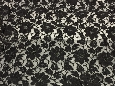
Clothing - Evening Wear, Black Lace Shawl, circa 1930s, 1930s
Doris Mercy Willmott was born in May 1896 in Stamford Hill, London, the eldest of three daughters of Albert and Minnie Willmott. The family lived in various parts of north London until the beginning of the First World War, when they moved to Redhill in Surrey. It was in Redhill that Doris met her future husband, Frederick John (Jack) Bennett. Jack had met Eric Mercy, a cousin of Minnie’s, in the Australian Imperial Force (AIF) and visited the Wilmotts with him whilst on leave from France. Although Jack Bennett returned to Melbourne in March 1919, he and Doris continued to correspond and they were engaged in March 1923. She came to Melbourne on her own, and was married in the Congregational Church in Canterbury on 23 December 1923. By 1931 Doris and Jack and their three sons - John Willmott, Winfield Robert Curtis and Peter Reginald Dane - moved to 21 Tooronga Road, Hawthorn but moved back to his father’s home, Therapia, 2 (now 6) Hepburn Street, Auburn, shortly before his father’s death. In 1937, the Bennett family moved back to the United Kingdom, spending the war years in Uxbridge and Torquay. The family returned to Melbourne in October 1946, after the deaths of Doris’ parents. The family lived at 12 Stanhope Grove, Camberwell and 51 The Ridge, Canterbury before Jack died in February 1952. After this Doris moved to 12 Stanley Grove, Canterbury, her home until c. 1970 when she moved to 25 Corhampton Road, North Balwyn. She died in May 1980 in Princeton Nursing Home, 3 Bellett Street, Camberwell. (Adapted from notes provided by Sue Barnett, the donor).The collection of evening clothes owned and worn by Doris Mercy Bennett, of which this item is one, date from the 1930s and may have been purchased in Australia or in the United Kingdom. Each of the items, apart from the evening dress, which has a few minor tears in the lace, is of fine quality and evidences Doris Bennett’s love of glamour and style. While the evening dress and the mantilla are of the same fabric, the two capes might have been worn with the dress as alternative fashion accessories. None of the items has a maker’s mark, however each displays evidence of fine dressmaking skills. It is however probable that the two fitted capes were commercially made.With the black lace evening dress (2917.0093.1) there is also a matching lace square with long lace ties (2017.0093.2) that might have been used as a mantilla or as a shawl. The outfit was owned and worn by Doris Mercy Bennett (nee Willmott) [1896-1980], and donated to the Society by her grandaughter. women's clothing, evening wear, shawls, lace, doris bennet (nee willmott) -
 Kew Historical Society Inc
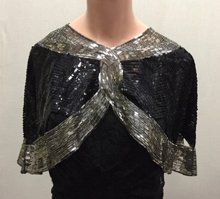
Clothing - Evening Wear, Black and Silver Sequin Capelet, 1930s, 1930s
Doris Mercy Willmott was born in May 1896 in Stamford Hill, London, the eldest of three daughters of Albert and Minnie Willmott. The family lived in various parts of north London until the beginning of the First World War, when they moved to Redhill in Surrey. It was in Redhill that Doris met her future husband, Frederick John (Jack) Bennett. Jack had met Eric Mercy, a cousin of Minnie’s, in the Australian Imperial Force (AIF) and visited the Wilmotts with him whilst on leave from France. Although Jack Bennett returned to Melbourne in March 1919, he and Doris continued to correspond and they were engaged in March 1923. She came to Melbourne on her own, and was married in the Congregational Church in Canterbury on 23 December 1923. By 1931 Doris and Jack and their three sons - John Willmott, Winfield Robert Curtis and Peter Reginald Dane - moved to 21 Tooronga Road, Hawthorn but moved back to his father’s home, Therapia, 2 (now 6) Hepburn Street, Auburn, shortly before his father’s death. In 1937, the Bennett family moved back to the United Kingdom, spending the war years in Uxbridge and Torquay. The family returned to Melbourne in October 1946, after the deaths of Doris’ parents. The family lived at 12 Stanhope Grove, Camberwell and 51 The Ridge, Canterbury before Jack died in February 1952. After this Doris moved to 12 Stanley Grove, Canterbury, her home until c. 1970 when she moved to 25 Corhampton Road, North Balwyn. She died in May 1980 in Princeton Nursing Home, 3 Bellett Street, Camberwell. (Adapted from notes provided by Sue Barnett, the donor).The collection of evening clothes owned and worn by Doris Mercy Bennett, of which this item is one, date from the 1930s and may have been purchased in Australia or in the United Kingdom. Each of the items, apart from the evening dress, which has a few minor tears in the lace, is of fine quality and evidences Doris Bennett’s love of glamour and style. While the evening dress and the mantilla are of the same fabric, the two capes might have been worn with the dress as alternative fashion accessories. None of the items has a maker’s mark, however each displays evidence of fine dressmaking skills. It is however probable that the two fitted capes were commercially made.Black silk chiffon or georgette fitted evening cape,let entirely covered in silver metal rectangles and black sequins. The cape gives the appearance of being joined at the front, however it is made in one piece. The cape has open scalloped sections bordering the lower band of silver metal rectangles. The cape was owned and worn by Doris Mercy Bennett (nee Willmott) [1896-1980], and donated to the Society by her grandaughter. evening wear, capelets, doris bennett (nee wilmott), women's clothing -
 Kew Historical Society Inc
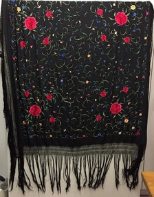
Clothing - Shawl, Manton de Manila, 1930s
Doris Mercy Willmott was born in May 1896 in Stamford Hill, London, the eldest of three daughters of Albert and Minnie Willmott. The family lived in various parts of north London until the beginning of the First World War, when they moved to Redhill in Surrey. It was in Redhill that Doris met her future husband, Frederick John (Jack) Bennett. Jack had met Eric Mercy, a cousin of Minnie’s, in the Australian Imperial Force (AIF) and visited the Wilmotts with him whilst on leave from France. Although Jack Bennett returned to Melbourne in March 1919, he and Doris continued to correspond and they were engaged in March 1923. She came to Melbourne on her own, and was married in the Congregational Church in Canterbury on 23 December 1923. By 1931 Doris and Jack and their three sons - John Willmott, Winfield Robert Curtis and Peter Reginald Dane - moved to 21 Tooronga Road, Hawthorn but moved back to his father’s home, Therapia, 2 (now 6) Hepburn Street, Auburn, shortly before his father’s death. In 1937, the Bennett family moved back to the United Kingdom, spending the war years in Uxbridge and Torquay. The family returned to Melbourne in October 1946, after the deaths of Doris’ parents. The family lived at 12 Stanhope Grove, Camberwell and 51 The Ridge, Canterbury before Jack died in February 1952. After this Doris moved to 12 Stanley Grove, Canterbury, her home until c. 1970 when she moved to 25 Corhampton Road, North Balwyn. She died in May 1980 in Princeton Nursing Home, 3 Bellett Street, Camberwell. (Adapted from notes provided by Sue Barnett, the donor).Black silk, with multi-coloured embroiderery Manton de Manila shawl. The shawl was owned and once worn by Doris Mercy Bennett (nee Willmott) [1896-1980], and donated to the Society by her grandaughter. It probably dates from the 1930s.evening wear, piano shawl, manton de manila, doris bennett (nee wilmot), women's clothing -
 Kew Historical Society Inc
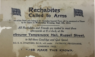
Memorabilia - Invitation, Rechabites: Called To Arms, 1914, 1914
An invitation to a meeting at the Temperance Hall, Russell Street, Melbourne to all members and friends in order to meet members of the Order who had joined the Australian Imperial Forces. The meeting was to be held after a dinner for the enlisted men on Wednesday evening, September 9th in 1914. The invitation and item 2017.0078 were discovered during renovations to the house situated at 31 (now 68) Charles Street, Kew. . rechabites - kew (vic.), kew recreation hall, first world war, ww1, 68 charles street - kew (vic.) -
 Kew Historical Society Inc
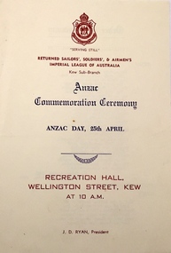
Programme, Anzac Day Commemoration Ceremony / RSSAILA Kew Sub-Branch, Undated
The Kew sub-branch of the Returned Soldiers and Sailors Imperial League of Australia was granted its Charter on 1 January 1920. Its first president was Sam Kilduff, who served with the 24th Battalion in the First World War (1914-1918) and was badly wounded in Belgium.Arthur Henry Dear was an employee of the City of Kew, acting as Hall Keeper of the Kew Recreation Hall in Wellington Street, and later the new Kew City Hall in Cotham Road. The Arthur Dear Collection contains memorabilia - tickets, programmes, invitations - as well as his identification badge. Items in the collection date from the 1940s to the 1960s. Programme for an Anzac Day Commemoration Ceremony hosted by the Kew Sub-branch of the RSSAILA in the Recreation Hall Kew on Friday 25th at 10am. The year is not noted in the programme.rssaila kew sub-branch, kew recreation hall -- wellington street, kew civic hall -- cotham road -
 Kew Historical Society Inc
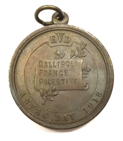
Medal, Education Department (Victoria), Anzac Day School Children's Medal, 1918
Anzac Day school children's medal, issued in 1918. The medal was distributed to every school child that year to commemorate Anzac Day. The Anzac forces first landed at Gallipoli on 25 April 1915. The medal sold to Victorian school children and the public to commemorate ANZAC Day, 25 April 1918. 250,000 medals were struck. Bronze medals were sold for 1 shilling and oxidised silver medals for 5 shillings. One-third of the proceeds was to be directed to the funding of a permanent institution for returned soldiers. [The Argus, 11 April 1918, p 8]This work forms part of the collection assembled by the historian Dorothy Rogers, that was donated to the Kew Historical Society by her son John Rogers in 2015. The manuscripts, photographs, maps, and documents were sourced by her from both family and local collections or produced as references for her print publications. Many were directly used by Rogers in writing ‘Lovely Old Homes of Kew’ (1961) and 'A History of Kew' (1973), or the numerous articles on local history that she produced for suburban newspapers. Most of the photographs in the collection include detailed annotations in her hand. The Rogers Collection provides a comprehensive insight into the working habits of a historian in the 1960s and 1970s. Together it forms the largest privately-donated collection within the archives of the Kew Historical Society.Bronze ANZAC Day medal distributed to all school children by the Department of Education in 1918 .Obverse has the bust of a uniformed soldier. The reverse image of the bust of an Australian soldier was adapted from a drawing by H. Harvey, an at assistant in the Victorian Education Department.Obverse: Bust of uniformed soldier wearing hat left; around, HONOR TO THE A.I.F. In small letters below bust, S&S 15C HH Reverse: Incuse on scroll which rests on olive branch, GALLIPOLI / FRANCE / PALESTINE; above EVD ; below, ANZAC DAY 1918anzac day medal (1918), commemorative medals, world war 1 - commemorations, australian commemorative medals -
 Kew Historical Society Inc
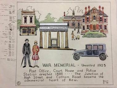
Work on paper, Joy Stewart, 6. War Memorial: Unveiled 1925, 1988
Kew Tapestry The eight panels depict the history of Kew. This was a 1988 Australian Bi-Centennial Project carried out under the auspices of City of Kew Council and the Kew Historical Society Incorporated. Nearly 600 citizens including many children participated in the production by adding a few or more stitches. A book records their names and the panels upon which they worked. Artist: Joy Stewart Co-ordinator: Dorothy BenyeiSydney Joy (Joy) Stewart was born in Melbourne 1925. She studied at Swinburne Technical College Art School from 1941-1945, then the National Gallery Art School 1946-1948. Her career included employment positions as a display artist, designer/painter, gallery assistant, and art teacher. Joy relocated to Cairns in 1981. Solo exhibitions in Melbourne and Cairns, including 'Done By Me' at Cairns Regional Gallery in 1999. Group exhibitions at Cairns Regional Gallery, 'The Fish John West Regrets, 1993' and 'Facets of Life' 1994. Joy Stewart died in Cairns in 2018.6. War Memorial: Unveiled 1925. A Handcoloured cartoon created by the artist Joy Stewart as a template for the sixth of a series of embroidered panels depicting the history of Kew. Wool colour codes at left. Inscription: "WAR MEMORIAL: Unveiled 1925. Post Office, Court House and Police Station erected 1888. ... The Junction of High Street and Cotham Road became the commercial heart of Kew." Signed by the artist "(c) JStewart, 1988"bicentennial project (kew), joy stewart, wwi, kew war memorial -
 Kew Historical Society Inc
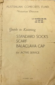
Booklet, Australian Comforts Fund (Victorian Divsion), Guide to Knitting Standard Socks Scarf Balaclava Cap for Active Service, 1939
Kew Historical Society, founded in 1958, has an extensive reference library, of which this book is a part. Volumes in the library are used by members for research into aspects of local history and/or to support the Society's collections of pictures, maps, fashion and artefacts. Reference books have entered the collection through donation, presentation, collection and purchase.Booklet advising on standards for knitting items for soldiersaustralian comforts fund (victoria), second world war 1939-1945