Showing 9606 items
matching h.
-
 Lakes Entrance Regional Historical Society (operating as Lakes Entrance History Centre & Museum)
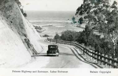
Postcard, Bulmer H D, 1930c
Black and copy 9 x 13.5, has inscription 'Princes Highway and Entrance, Lakes Entrance', ink spill on photo top right hand areaTinted small format postcard of the Princes Highway winding around Jemmys Point, between the steep road cutting and post and rail fence, entrance to Gippsland Lakes in the distance. Lakes Entrance Victoriafences, waterways, roads and streets -
 Lakes Entrance Regional Historical Society (operating as Lakes Entrance History Centre & Museum)
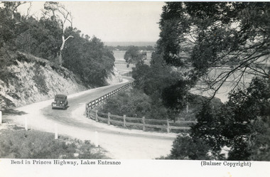
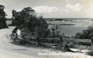
Postcard, Bulmer H D, 1950c
Black and white postcard of the Princes Highway as it winds around Jemmys Point. A motor car driving up the hill between steep road cutting and post and rail fence. View of the lake and ocean in the distance. Lakes Entrance VictoriaBend in Princes Highway, Lakes Entranceislands, fences, waterways, roads and streets -
 Lakes Entrance Regional Historical Society (operating as Lakes Entrance History Centre & Museum)
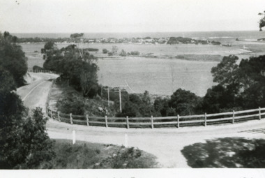
Postcard, Bulmer H D, 1950c
Also one other postcard same donated by M & V Carpenter in spares box.Black and white postcard of the Princes Highway Jemmys Point, showing Bullock Island between North Arm and Cunninghame Arm, distant view of the entrance from Bass Strait to the Gippsland Lakes. Post and rail fence along roadside. Lakes Entrance VictoriaPrinces Highway and a view of the Entranceguesthouses, restaurant, vegetation, tearoom -
 Lakes Entrance Regional Historical Society (operating as Lakes Entrance History Centre & Museum)
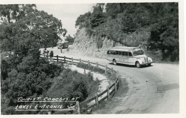
Postcard, Bulmer H D, 1960c
1 other copyBlack and white postcard of a bend in the Princes Highway at Jemmys Point. It shows two tourist coaches on the road between the steep road cutting and the post and rail fence, gravel footpath on road side of fence. Man directing traffic. Lakes Entrance VictoriaTourist coaches at Lakes Entrance, Victourism, vegetation, restaurant -
 Lakes Entrance Regional Historical Society (operating as Lakes Entrance History Centre & Museum)
Postcard, Bulmer H D, 1920c
Black and white copy same sizeTinted postcard of a bend in the Princes Highway, Jemmys Point. It shows the road between the steep cutting and post and rail fence. Glimpse of footbridge to Bullock Island, entrance and hummocks. Lakes Entrance VictoriaPrinces Highway, Lakes Entrancehouses, topography, waterways -
 Lakes Entrance Regional Historical Society (operating as Lakes Entrance History Centre & Museum)
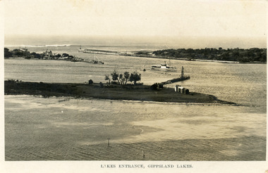
Postcard, Bulmer H D, 1923c
Also same image|Faded copy 10x15|Black and White 12x17.5|Black and White 20x28.5Black and white postcard of the entrance to the Gippsland Lakes, showing buildings at New Works, cranes on ends of piers, jetty and bathing boxes on bullock Island, steamer passing island. Lakes Entrance VictoriaLakes Entrance, Gippsland Lakeswaterways, islands, topography -
 Lakes Entrance Regional Historical Society (operating as Lakes Entrance History Centre & Museum)
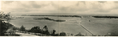
Postcard, Bulmer H D No 15
Black and white double size postcard of Bullock Island. It shows a glimpse of the Princes Highway in foreground, wooden foot bridge to Bullock Island, houses on the hummocks, entrance and Bass Strait in background, boat entering lakes. Lakes Entrance VictoriaPanorama of Lakes Entrance from Princes Highwaywaterways, islands, township, civil engineering -
 Lakes Entrance Regional Historical Society (operating as Lakes Entrance History Centre & Museum)
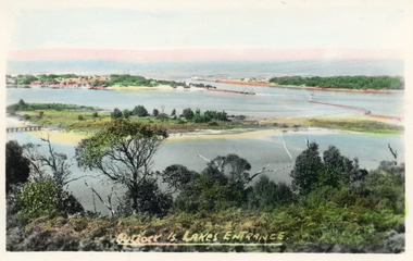
Postcard, Bulmer H D, 1920c
Hand coloured postcard of Bullock Island and the man made entrance from Bass Strait to the Gippsland Lakes. Also shown the small township, unofficially known as Carpentertown at the entrance works. Photo taken from Kalimna Hill, shrubbery in foreground. Lakes Entrance VictoriaBullock Island, Lakes Entrancewaterways, bridges, islands, jetties -
 Lakes Entrance Regional Historical Society (operating as Lakes Entrance History Centre & Museum)
Postcard, Bulmer H D, 1920c
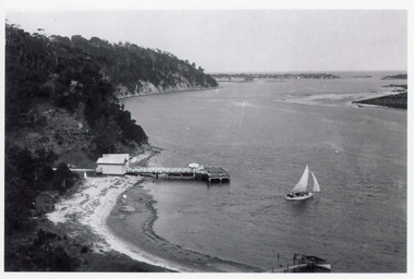
Black and white postcard of Kalimna Jetty. It shows a jetty with painted railings, storage shed with square water tank, low lying shore of lake in foreground contrasting with steep cliffs beyond jetty. Boat moored at a small jetty in foreground, yacht sailing from jetty, glimpse of Rigby Island and Bullock Island and the New Works area in distance. Lakes Entrance Victoriajetties, waterways, township, tourism -
 Lakes Entrance Regional Historical Society (operating as Lakes Entrance History Centre & Museum)
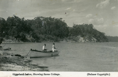
Postcard, Bulmer H D, 1930c
Second copy 16.5 x 25, speckly conditionFirst generation black and white postcard of two people fishing from a small boat moored on the shore at Gippsland Lakes. Also shows steep cliffs bordering lake, glimpse of Cliff Crest Tea Rooms, run by Mrs Westerson. Lakes Entrance VictoriaGippsland Lakes showing Scone Cottagehouses -
 Lakes Entrance Regional Historical Society (operating as Lakes Entrance History Centre & Museum)
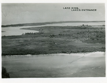
Postcard, Bulmer H D, 1950c
Two other copies same sizeBlack and white small format postcard showing part of Rigby Island, Reeves Channel, Hopetoun Channel, The Barrier, on Gippsland Lakes, Victoria, showing foreground bushes, and Bass Strait in distance.Lake King Lakes Entranceislands, waterways, topography -
 Lakes Entrance Regional Historical Society (operating as Lakes Entrance History Centre & Museum)
Postcard, Bulmer H D, 1922c
Black and white photographic postcard, showing early aerial view of township of Lakes Entrance, Cunninghame Arm, North Arm and sand dunes, ocean in lower foreground, Eastern wharf and various boats on lake. Princes Highway went along Esplanade, Myer Street and Roadknight Street, very little vegetation on sand dunes, no foot bridge yet, good view of North Arm, few houses. Lakes Entrance VictoriaLakes Entrance and Backwater from the Air.islands, aerial photograph, waterways, topography, township -
 Lakes Entrance Regional Historical Society (operating as Lakes Entrance History Centre & Museum)
Photograph, Bulmer H D, 1923c
Second copyBlack and white photograph showing aerial view of the entrance to the Gippsland Lakes, shows Cunninghame Arm, North Arm, Reeves River and Hopetoun Channel, Rigby Island and Snake Island, the barrier on right foreground. Lakes Entrance Victoriawaterways, islands, aerial photograph, fishing industry, coast -
 Lakes Entrance Regional Historical Society (operating as Lakes Entrance History Centre & Museum)
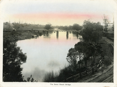
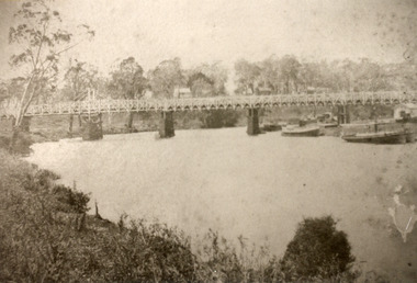
Postcard, Bulmer, H D, 1915
Colour tinted large format postcard showing lifting bridge over the Tambo River, at Swan Reach, Victoria. Bridge is closed to allow road traffic through. Rough gravel road to Metung on right. Landing on left near bridge. Vegetation on river bank right. Houses in distance on both sides of river.The Swan Reach Bridgeboats and boating, bridges -
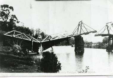 Lakes Entrance Regional Historical Society (operating as Lakes Entrance History Centre & Museum)
Photograph, Bulmer H D, 1925
Swan Reach Bridge collapsed 10.00 am 16 November 1925Black and white photograph showing collapsed bridge over the Tambo River, bridge collapsed at eastern end. Photo looking downstream. Two people on landing on far right bank behind right hand bridge pylon. Thick vegetation on bank. Swan Reach VictoriaSwan Reach Bridge on the Tambo Riverwaterways, boats and boating -
 Lakes Entrance Regional Historical Society (operating as Lakes Entrance History Centre & Museum)
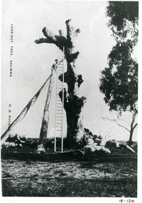
Photograph, Bulmer H D, 1915
Also copy 15 x 10 same imageBlack and white photograph copied from a postcard of the LookOut Tree on Jemmys Point, shows the standing dead grey box tree supported by two heavy logs, a 35 foot ladder attached for access to top. Lakes Entrance Victoria.historic sites, navigation, people -
 Lakes Entrance Regional Historical Society (operating as Lakes Entrance History Centre & Museum)
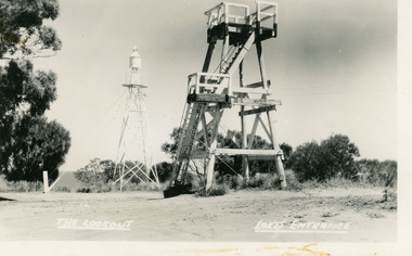
Postcard, Bulmer H D, 1943
Also two larger copies, 11.5 x18 cm and 17 x 25.5 cm|Also an original in good order 02269.04|This is the before paired photograph used in the 150 year Lakes Entrance 1858-2008 display.|The after paired photograph number 02269.1|Also one 12 x 16 framed photograph used in room display.Black and white postcard of the timber lookout tower on Jemmys Point, Lakes Entrance, Victoria, showing the lookout between the old lookout tree, and the steel signal light tower. Below the lookout is a timber shed built during WW2 when tower was used by Kalimna Air Observors Corps. In foreground is a wooden seat replacing the old log shelter and seat.Jemmys Point Lakes Entrancenavigation, room display -
 Lakes Entrance Regional Historical Society (operating as Lakes Entrance History Centre & Museum)
Postcard, Bulmer H D, 1950
Black and white postcard of the timber lookout on Jemmys Point, with the signal light on steel tower nearby. Lakes Entrance Victoria,The Lookout, Lakes Entrancehistoric sites, navigation -
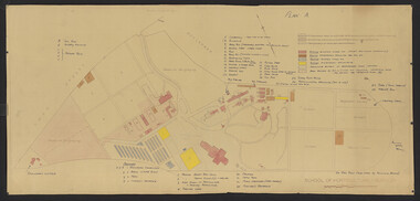 University of Melbourne, Burnley Campus Archives
Plan - Coloured plan, Thomas H. Kneen, School of Horticulture - Burnley, 1948-1949
Colour-coded to show existing and proposed buildings, numbered and lettered to indicate use of buildings Related documents: B91.476, B91.484Plan with handwritten amendments by T.H. Kneen on 24.10.1949. Extensive explanation of existing and proposed structures at the College. Plan A: area bounded by Swan St., Yarra Boulevard, reserves for grazing, orchard and vegetable gardens along southern boundary. Amended 24/10/49 T.H. Kneent.h. kneen, burnley gardens, burnley school of horticulture, farm buildings -
 University of Melbourne, Burnley Campus Archives
Book - Register, Thomas H. Kneen, Hydrangeas, 1948
2 copies list of Hydrangea varieties. From T.H. Kneen file marked February.Handwritten on 1 copy, 'Donated by Mr. N. Sable, Blessington St. Gardens, St Kilda, early Feb 1948.' t.h. kneen, hydrangeas, flowers, n. sable, blessington st. gardens, st kilda -
 Lakes Entrance Regional Historical Society (operating as Lakes Entrance History Centre & Museum)
Photograph, Bulmer, H D, 1887
Black and white photograph of the first road bridge over the Mitchell River at Bairnsdale, Victoria.township, waterways -
 Lakes Entrance Regional Historical Society (operating as Lakes Entrance History Centre & Museum)
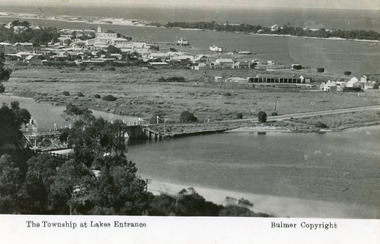
Postcard, Bulmer H D, 1935
Marine Parade has not yet been formed through the low lying marshy area adjacent to North Arm. Very little vegetation on Eastern end of hummocks.Black and white postcard of the western end of Lakes Entrance,showing a glimpse of the North Arm bridge, town situated adjacent to Cunninghame Arm, sand hummocks and ocean in distance. Lakes Entrance VictoriaThe Township at Lakes Entrancetownship, waterways, bridges, hotels -
 Lakes Entrance Regional Historical Society (operating as Lakes Entrance History Centre & Museum)
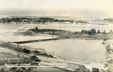
Postcard, Bulmer H D, 1945
Black and white postcard of Bullock Island, Lakes Entrance, showing an extensive rock groyne to the south of the island, into which dredged sand and spoil is to be placed in order to extend the island's area. North Arm bridge, Bullock Island footbridge, New Works settlement and Entrance channel also in image. Lakes Entrance VictoriaBullock Island, Lakes Entranceboats and boating, fishing industry, islands -
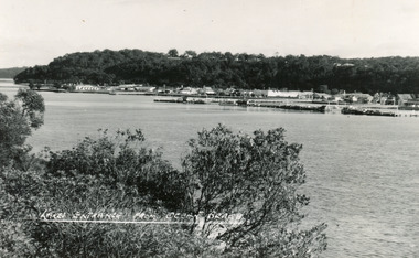 Lakes Entrance Regional Historical Society (operating as Lakes Entrance History Centre & Museum)
Postcard, Bulmer H D, 1950
Black and white postcard of the township of Lakes Entrance, taken form the south bank of Cunninghame Arm, showing the boat haven, buildings along Esplanade, and the Kalimna escarpment in the distance. Lakes Entrance VictoriaOcean Beach at Lakes Entrancetownship, transport -
 Lakes Entrance Regional Historical Society (operating as Lakes Entrance History Centre & Museum)
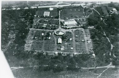
Photograph, Bulmer H D, 1935
Black and white aerial view of Whiters Camp Park, looking south to Roadknight Street. Shows layout of camping facilities, including sites, tennis courts, rotunda, and family home which incorporated shop with all requirements for a holiday. Lakes Entrance Victoriatourism, resort, aerial photograph, camping -
 Lakes Entrance Regional Historical Society (operating as Lakes Entrance History Centre & Museum)
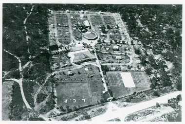
Photograph, Bulmer H D, 1935
Black and white aerial view of Whiters Camp Park, looking north from Roadknight Street, showing layout of park including tennis courts, bowling green, picnic area, cottages, rotunda, and the family residence. Lakes Entrance Victoriaguesthouses, tourism, people -
 Lakes Entrance Regional Historical Society (operating as Lakes Entrance History Centre & Museum)
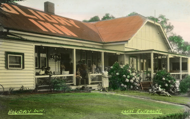
Postcard, Bulmer H D, 1945
Colour tinted postcard of Holiday Inn, Kalimna, showing twelve people on veranders, two adults and child on lawn. Guesthouse appears to be a conglomerate of disparate additions to its original tea rooms status. Lakes Entrance Victoriatopography, waterways, jetties -
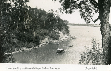 Lakes Entrance Regional Historical Society (operating as Lakes Entrance History Centre & Museum)
Postcard, Bulmer H D, 1945
'Scone Cottage' aka 'Cliff Crest' was a popular destination for tourists, who were conveyed to the boat landing by local tourist launches, whence the visitors climbed the steep zigzag path to the cottage.Black and white postcard showing a tourist launch leaving a rustic jetty below timbered cliffs at Nungurner near Lakes Entrance, Victoria.Scone Cottage Cottage, Lakes Entrance.topography, ocean, waterways -
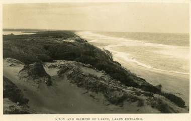 Lakes Entrance Regional Historical Society (operating as Lakes Entrance History Centre & Museum)
Postcard, Bulmer H D, 1940
Black and white postcard taken from the hummocks to the west. View is looking to the east showing ocean and beach, wind swept scrub covered dunes, and distant view of Gippsland Lakes. Lakes Entrance Victoriawaterfront, public works, ocean, public works -
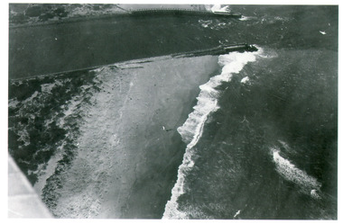 Lakes Entrance Regional Historical Society (operating as Lakes Entrance History Centre & Museum)
Photograph, Bulmer H D, 1935
Black and white photograph of the entrance, shows entrance channel east and west piers, ocean surf breaking on sandy beach. Lakes Entrance Victoriawaterfront, public works, jetties