Showing 17150 items
matching bay-bridge
-
 Federation University Historical Collection
Photograph, Two black and white photographs at Wentworth
Jack (John R) Watson and Herb (Ernest Herbert) Smith at Wentworth..1 Bridge at Wentworth .2 Loch at Wentworth.1 verso - Bridge at Wentworth .2 verso - Loch at Wentworth Herb and Jackwentworth, bridge - wentworth, loch - wentworth -
 Eltham District Historical Society Inc
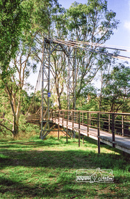
Photograph, Pedestrian suspension bridge over the Yarra River at Lower Plenty, 18 Apr 1998, 1998
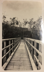
Lower Plenty Heritage Excursion included the former monastery of the Blessed Sacrament Fathers, now Odyssey House, and its suspension footbridge across the Yarra River. Odyssey House drug rehabilitation centre in Bonds Road, Lower Plenty is a distinctive landmark, especially when viewed from across the Yarra at Templestowe. It was built in the 1950’s as a seminary for the Blessed Sacrament Fathers. Because of the poor and circuitous road access, a suspension footbridge was built across the river. As well as providing easy access for the priests residents of Templestowe could attend services at the seminary. The bridge is now part of the Yarra Trails system.Roll of 35mm colour negative film, 6 strips Also photographic prints 10 x 15 cmKodak Gold 200-6activities, blessed sacrament fathers, bonds road, bridge, foot bridge, lower plenty, odyssey house, seminary, yarra river -
 Eltham District Historical Society Inc
Photograph, Pedestrian suspension bridge over the Yarra River at Lower Plenty, 18 Apr 1998, 1998
Lower Plenty Heritage Excursion included the former monastery of the Blessed Sacrament Fathers, now Odyssey House, and its suspension footbridge across the Yarra River. Odyssey House drug rehabilitation centre in Bonds Road, Lower Plenty is a distinctive landmark, especially when viewed from across the Yarra at Templestowe. It was built in the 1950’s as a seminary for the Blessed Sacrament Fathers. Because of the poor and circuitous road access, a suspension footbridge was built across the river. As well as providing easy access for the priests residents of Templestowe could attend services at the seminary. The bridge is now part of the Yarra Trails system.Roll of 35mm colour negative film, 6 strips Also photographic prints 10 x 15 cmKodak Gold 200-6activities, blessed sacrament fathers, bonds road, bridge, foot bridge, lower plenty, odyssey house, seminary, yarra river -
 Phillip Island and District Historical Society Inc.
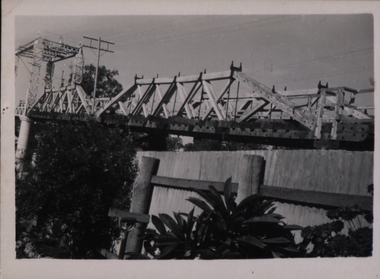
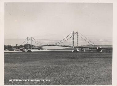
Photograph, 1940's - 1950's
One of a collection of 9 photographs donated by the former Shire of Phillip Island. This photo was part of a pack of postcards sold to the tourists/visitors to Phillip Island.Black & White photograph of view eastward from Cleeland Bight of the Phillip Island/San Remo Suspension Bridge. The photo is part of a set."The Suspension Bridge San Remo"suspension bridge san remo/phillip island, phillip island suspension bridge, bridges, shire of phillip island -
 Tatura Irrigation & Wartime Camps Museum
Photograph, Clark D, 1989
Waranga Basin commenced in 1902Black and white photograph of Waranga - Mallee channel, flowing under bridge on Tatura - Rushworth road.on back - Bridge over Waranga - Mallee channelwaranga basin -
 Eltham District Historical Society Inc
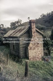
Slide, Pills Cottage, Heidelberg-Kinglake Road, Cottles Bridge, Vic, c.1970
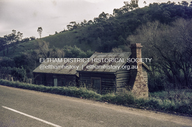
Pills Cottage about halfway from Cottles Bridge to St Andrews near 1575 Heidelberg-Kinglake Road, St Andrews. William John "Bill" Pill was born on 19th June 1894 at Diamond Creek He was brutally murdered on 21st December 1958 age 64, in his cottage. His father was John Henry Pill, born 24 November 1856, Lalone, Perranzabuloe, Cornwall, England, He died 21 December 1930 at Cottles Bridge, His mother was Jessie Ann Whatmough, born 6th June 1870. She died 21 August 1921. William John "Bill '' Pill, grew tomatoes on his rich two and a half acres. In 2024 his second cousin Steve Whatmough recalled visiting Bill in 1957 with his parents (Eric and Nancy Whatmough) and Bill showing them his tomatoes. He had a very large aeroplane propeller set up at one end on his tomato crop. He would run the propeller on frosty mornings to keep away the frost damage. His tomatoes would ripen early and would receive a premium price for them. The cottage consisted of two buildings. The one closest in the right side of the photo was the kitchen. The second building that also has a chimney was his bedroom and living room.35 mm colour positive transparency Mount - Agfacolor Service (Blue)heidelberg-kinglake road, pills cottage, st andrews, william john pill, bill pill, john henry pill, jessie ann pill (nee whatmough), market gardener, murder, cottles bridge (vic.), tomato farm, mount - agfacolor service (blue), scan - 35mm positive -
 Eltham District Historical Society Inc
Slide, Pills Cottage, Heidelberg-Kinglake Road, Cottles Bridge, Vic, c.1970
Pills Cottage about halfway from Cottles Bridge to St Andrews near 1575 Heidelberg-Kinglake Road, St Andrews. William John "Bill" Pill was born on 19th June 1894 at Diamond Creek He was brutally murdered on 21st December 1958 age 64, in his cottage. His father was John Henry Pill, born 24 November 1856, Lalone, Perranzabuloe, Cornwall, England, He died 21 December 1930 at Cottles Bridge, His mother was Jessie Ann Whatmough, born 6th June 1870. She died 21 August 1921. William John "Bill '' Pill, grew tomatoes on his rich two and a half acres. In 2024 his second cousin Steve Whatmough recalled visiting Bill in 1957 with his parents (Eric and Nancy Whatmough) and Bill showing them his tomatoes. He had a very large aeroplane propeller set up at one end on his tomato crop. He would run the propeller on frosty mornings to keep away the frost damage. His tomatoes would ripen early and would receive a premium price for them. The cottage consisted of two buildings. The one closest in the right side of the photo was the kitchen. The second building that also has a chimney was his bedroom and living room.35 mm colour positive transparency Mount - Agfacolor Service (Blue)bill pill, cottles bridge (vic.), heidelberg-kinglake road, jessie ann pill (nee whatmough), john henry pill, market gardener, mount - agfacolor service (blue), murder, pills cottage, scan - 35mm positive, st andrews, tomato farm, william john pill -
 Eltham District Historical Society Inc
Negative - Photograph, The Bridge, Hurstbridge, Vic, c.1925
Copied from brochure "Wattle Valley Estate" 7 minutes from the bridge. The new bridge designed by Sir John Monash over the Diamond Creek near Hurst's home of 'Mia Mia' at Hurstbridge. The Wattle Valley Estate was first advertised in August 1925 as weekend building allotments by the Greater Melbourne Land and Development Company. Advertised from £28.10.0 or £60 per block. In August 1926, 30 picked allotments of 60x150 feet were put up for auction Saturday August 14, 1926 with frontages to Valley View Road and Fawkner Crescent advertised in the “Heart of the Glorious Wattle Country” and “Within 15 Minutes of the Newly Electrified Railway Station”. The Advertiser on August 13, 1926 in an article promoting the auction stated “the estate is regarded as one of the best in the district, and will be sold practically without reserve.” It is noted that an advertisement running in The Argus February 22, 1951 offered the remaining 16 blocks for sale at £12.10.0 or £200 the lot. By March 7, the remaining blocks were advertised at £17.10.0 The Wattle Valley Estate took over 20 years to sell and then people could not build on them This image was also used in a brochure advertising the "Wattle Valley Estate", which forms part of the Shire of Eltham Pioneers Photograph Collection (Cross Reference Photo No.(s): 1056, 1057)This photo forms part of a collection of photographs gathered by the Shire of Eltham for their centenary project book,"Pioneers and Painters: 100 years of the Shire of Eltham" by Alan Marshall (1971). The collection of over 500 images is held in partnership between Eltham District Historical Society and Yarra Plenty Regional Library (Eltham Library) and is now formally known as the 'The Shire of Eltham Pioneers Photograph Collection.' It is significant in being the first community sourced collection representing the places and people of the Shire's first one hundred years.Digital image 4 x 5 inch B&W Negshire of eltham pioneers photograph collection, hurstbridge, bridge, diamond creek (creek), monash bridge, wattle valley estate -
 Kew Historical Society Inc
Photograph - Zig-Zag Bridge, 1924
Henry Beater Christian (1886-1962) , was a descendant of one of the earliest settler families in Kew. Employed at the Kew Asylum as a 'public servant', he was a skilled amateur photographer, photographing numerous scenes in Kew and on his travels around Victoria. The majority of his photographs date from 1916 to 1929. His finest photographs are housed in two photograph albums. Digital copy of a photograph from page 8 of the 47-page photograph album containing 261 gelatinous silver images, loaned by Diane Washfold with permission given to digitise and hold a copy in our collection. The Zig-Zag Bridge linked the grounds of the Yarra Bend and Kew Asylums. The wooden bridge was constructed in the 1870s and lasted through numerous floods until its destruction in 1929. A horizontal structure, the walkway was reached via a wooden staircase on the Kew bank of the river. The steps were required due to the different levels of the banks on this stretch of the river. The photo is taken from the Kew side of the river and shows clearly the width of the walkway on top of the bridge. "Zig-Zag Bridge"henry beater christian (1886-1962), landscape photography, kew (vic.) — yarra river, christian-washfold collection, photograph albums, zig-zag bridge -
 Eltham District Historical Society Inc
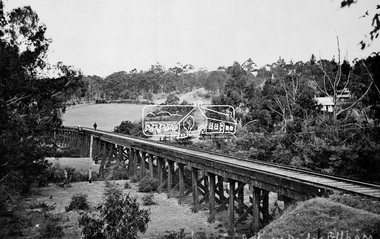
Negative - Photograph, Tom Prior, Railway Trestle Bridge over the Diamond Creek, Eltham, Vic, c.1910
Railway Trestle Bridge over the Diamond Creek, Eltham, c.1910 - looking towards Main Road (left to right) and Henry Street (centre). Built in 1901, the railway line was electrified in 1923. Photo was taken prior to 1912 and the relocation of the new St Mary’s Catholic Church on Henry Street near Main Road (or Maria Street). The church site was relocated c.1912 from further south along Main Road (near Wingrove Cottage) to be more central to the congregation following the shifting of the township away from Little Eltham and closer to the railway station. It was subsequently destroyed by fire in 1961.This photo forms part of a collection of photographs gathered by the Shire of Eltham for their centenary project book,"Pioneers and Painters: 100 years of the Shire of Eltham" by Alan Marshall (1971). The collection of over 500 images is held in partnership between Eltham District Historical Society and Yarra Plenty Regional Library (Eltham Library) and is now formally known as the 'The Shire of Eltham Pioneers Photograph Collection.' It is significant in being the first community sourced collection representing the places and people of the Shire's first one hundred years. The Reynolds family were early settlers in Research. The Reynolds/ Prior collection of photographs were taken by Tom Prior, the maternal uncle of Ivy Reynolds, around 1900 and the 60 photos in the album give a fine overview of many of the landmarks of Research and Eltham over 100 years ago. lvy lived in the family home for many years at 106 Thompson Cres Research. Ivy's father, Ernst Richard Reynolds and grandfather, Richard Reynolds, lived at the same address. Ivy's father Richard worked for Mr. Trail on his property in Research. Reynolds Road is named after the family. Mr Tom Prior (wife Eva) worked at the Melbourne zoo. He was very innovative and made his own camera, using the black cloth hood to exclude the light. The photographs are a reminder of the rural nature of Research and Eltham and its rich heritage.Digital image 4 x 5 inch B&W Negshire of eltham pioneers photograph collection, bridge, diamond creek (creek), eltham, eltham railway trestle bridge, henry street, main road, reynolds prior collection, trestle bridge -
 City of Ballarat Libraries
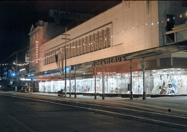
35mm Slide, Morshead's Department Store, Bridge Street Ballarat, circa 1950s
Morshead's was a popular department store in the 1950s and 1960s. In this night exposure the famous window displays can be clearly seen. Also at the extreme right of the photograph the verandah over 'the bridge' can be seen - the creek is covered over making an arcade. Also the verandah posts which were all removed in the 1960s and cantilevered verandahs installed throughout Ballarat. Mrs Bon Strange and her husband Bert were well known Ballarat residents. When Mrs Strange died some years ago, her extensive slide collection was sorted through and those relevant to Ballarat were gifted to the Ballarat Library. bridge street, department store, trams, illuminations, shop windows, advertising -
 Phillip Island and District Historical Society Inc.
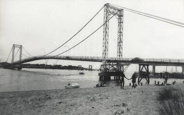
Photograph, Phillip Island Bridges, 1968/9
Shows first Bridge carrying traffic with 1969 Bridge just being constructed. From the Jack Jenner CollectionOld suspension Bridge with New Bridge appearing in background. Speed Boat middle foreground. local history, photographs, civil engineering, bridges, phillip island bridge, black & white photograph, jack jenner collection, phillip island bridges, public construction -
 Ballarat Tramway Museum
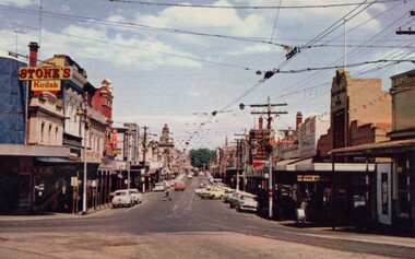
Photograph - Digital Image, Bridge Street
Yields information about the appearance of Bridge St early 1960's and the buildings on either side. Shows the festoon lighting.Digital Copy of a photograph sourced by Roger Greenwood as part of his work on the production of a Video Tape on Ballarat's trams. Photographer and source details not provided by Roger. See btm6304doc.pdf Image looking west along Bridge St Ballarat with the festoon lighting in position. See Reg Item 6303i. This image appears to be early 1960's, possibly a bogie tram with yellow stripping at the Grenville St end, but not the large white stripe. Has the Stones Corner and The State Bank buildings in the view. Photo from a postcard, published c1967 as advised in the e-mail of 20/7/15. Print in box 13 trams, tramways, bridge st, stones corner, main road -
 Port Melbourne Historical & Preservation Society
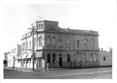
Photograph - Chequers Inn, 316 Bay Street, cnr. Bridge Street, Port Melbourne, Janet and Allen Walsh, 1973
Shot in 1973 with particular interest in architectureSet of 31 photographs taken in June and July 1973 Chequers Inn, Bay and Bridge StsIdentified and dated on back in inkbuilt environment - commercial, built environment - domestic, built environment - industrial, janet walsh, allen walsh, bay street, bridge street, chequers inn -
 Clunes Museum
Photograph
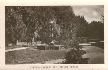
CLUNES QUEEN'S PARK GARDEN'S.1 ORIGINAL POSTCARD OF CLUNES QUEEN'S GARDEN. FOUNTAIN IN THE FOREGROUND. JUBILEE BRIDGE IN THE BACKGROUND .2 PHOTOCOPY OF POSTCARD .3 ENLARGED PHOTOCOPY OF POSTCARDQUEEN'S GARDENS AND JUBILEE BRIDGE.postcard, queen's park garden -
 Eltham District Historical Society Inc
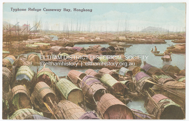
Photograph - Postcard, Postcard: No. 34. Typhoon Refuge, Causeway Bay, Hongkong, c.1910s - c.1920s
Specially Made for: The Graeco Egyptian Tobacco Store. Hongkong.This item, a souvenir from Hongkong from between the wars (circa 1923) was brought home to Research, Victoria by Bill Teagle who was serving in the Royal Australian Navy (1919-1945). According to Bill's neice Valerie Waller (nee Feldbauer, daughter of Violet and Theodore 'Curly' Feldbauer), her Uncle Bill would always bring some sort of souvenir home from his travels for family members. The item ( along with a series of postcards from Japan of the Great Kanto Earthquake of 1 September 1923) was possibly given by Bill Teagle to his sister Margaret Rose (formerly Ingram) who later married Richard Edward (Eddie) Fielding in early 1948. (Eddie had been engaged to someone else before he went to war, but his fiancée broke it off before his return to Australia.) It was cared for by the Teagle/Fielding family for approximately one hundred years. It is of particular significance given the family's connection to the Eltham War Memorial through 'Curly' Feldbauer and the significance of that memorial to the local community and represents that despite the horrors of war, former friends then foes can become friends again.tom fielding collection, postcard, hongkong, a. h. & co. hongkong, the graeco egyptian tobacco store -
 Federation University Historical Collection
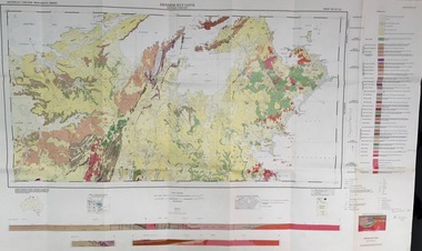
Map - Geological, Arnham Bay-Cove, Northern Territory: 1:250,000 Geological Series SD 53,4, 1968
-
 Footscray Community Arts
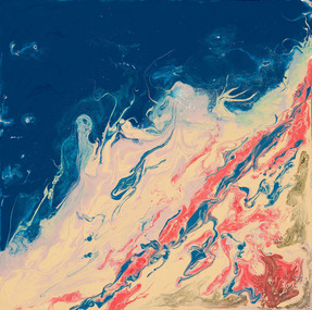
Tranquility/Cat Shark Bay, Monika Zechetmayr, (exact); 2009
MEDIUM: Acrylic on canvas DESCRIPTION: -
 Mission to Seafarers Victoria
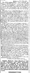
Article - Newspaper clipping, Argus newspaper, Seamen's floating church in Hobson's Bay, 2 July 1857
After an attempt of building a Seamen's Hospital in Williamstown, the ship Emily was transformed in a floating chapel to welcome seamen for service. Captain Charles Ferguson (1813-1868) was one of the members of the committee who founded the floating church. The ship Emily may have been a convict ship sailing from England to the Van Diemen's land in 1842 and 1844. Before 1856, it was used as a "water police hulk" then transformed in an accommodation for Reverend Kerr Johnson and his large family and fitted to receive 200 attendees in the chapel.The article is significant as it describes the ship and its location: "The hulk is moored midway between Sandridge and Williamstown, and is distinguished by a blue flag flying at the mainmast with "Bethel" inscribed on it; and in one corner of the flag is the star of Bethlehem, in another a dove with an olive branch."1 column article in the Argusship emily, floating church, reverend kerr johnston, 1812-1887, hobson's bay, sandridge, captain ferguson, captain charles ferguson (1813-1868), convict ships -
Phillip Island and District Historical Society Inc.
Book, LONEY, J. K. (Jack Kenneth), Bay steamers and coastal ferries, 1988, c1982
-
Phillip Island and District Historical Society Inc.
Book, Geographia, Isle of Wight : the holiday island ; including Cowes, Newport, Carisbrooke, Ryde, Bembridge, Brading, Sandown, Shanklin, Godshill, Ventnor, Alum Bay, Freshwater, Yarmouth, Newtown, 1977
isle of wight, england, description, travel, history -
Phillip Island and District Historical Society Inc.
Book, Ministry for Conservation (Victoria), Westernportrait : an explanation of the Westernport Bay environmental study, 1975
Stamped 'Phillip Island & District Historical Society'.conservation, natural resources, victoria, western port region, reports, surveys -
Phillip Island and District Historical Society Inc.
Book, GUTHRIE, Margaret D, First tourist : commemorating the bicentenary of Matthew Flinders' voyage in the sloop 'Norfolk' to Bribie Island and Moreton Bay, 1799-1999, 1999
Best wishes to the Phillip Island Historical Society from Bribie Island. Margaret D. Guthrie, 2003matthew flinders, journeys, genealogy, bribie island, queensland, discovery, exploration, history -
 Mission to Seafarers Victoria
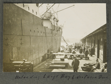
Photograph - Photograph, Sepia, Unloading Large Bay 6 Victoria Dock
on page 6victoria dock, unloading, stevedores, fan album, victoria harbour, sheds -
Lorne Historical Society
Map - Subdivision Map, J Batten Lithos, Plan of West Lorne Loutitt Bay Allotments IV and V
One of the early subdivision maps of Lorne.Black and white printed map on cream paper. The map shows allotments from the Erskine River to the Grand Pacific with an inset of allotments between Smith and Otway Streets. Allotments have the owners names.. The sea baths, Cobb and Co stables , Mountjoys Hotel, the Church of England, the telegraph line to Geelong and the jetty are also marked.lorne, subdivisions, -
 Mission to Seafarers Victoria
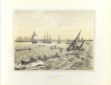
Print - Framed print, Francois Cogne, Sandridge from Hobson's Bay 1863, 1863
Busy port of Melbourne and Sandridge beachfront where the Bethel church was built on the Custom House land.Medium size framed print francois cogne (1829-1883), hobson's bay, sandridge, williamstown, bethel church, reverend kerr johnston, 1812-1887, customs house, artwork-paintings -
 Glenelg Shire Council Cultural Collection
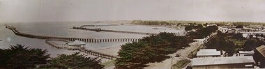
Mixed media - Photocard - Colour Panorama, Portland Bay, Colour Panorama, Portland Bay, n.d
Displayed at History HouseTinted photo. Baths with blue roof in foreground. Fisherman's Wharf in background, Long Pier, Railway Pier, and Cypress Trees along Bentinck Street. Telegraph Poles along Street. Truck carrying bales. Mounted on cardboard.Front: Panorama of Portland, Victoria (Length of Ocean Pier, 2880 ft). -
 Eltham District Historical Society Inc
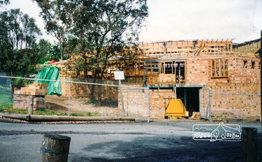
Photograph, Cr. Peter Graham, Library office and the loading bay entry, Eltham Library construction, Oct 1993, 1993
Construction of the new Eltham Library 1993-1994. Officially opened 22 May 1994. Formerly mounted on display card 40 x 50 cm (9 images)Colour photographconstruction, eltham library -
 Warrnambool RSL Sub Branch
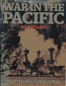
Book, WAR IN THE PACIFIC. PEARL HABOUR TO TOKYO BAY
Hardback with dust coverAuthor John Winton Publisher Sidgwick & Jackson London: 1978 ISBN: 0 09 135260 6 -
Port Melbourne Historical & Preservation Society
Programme, Port Melbourne Festival Tops the Bay, Feb 1994
Produced by the Port Melbourne Festival Committee, distributed throughout the municipalityPort Melbourne Festival program for 1994, 26/27 February; A5 size on blue paperarts and entertainment, celebrations fetes and exhibitions, port melbourne festival committee