Showing 10957 items matching "land "
-
 Port Melbourne Historical & Preservation Society
Booklet, Framework for the Future, Dec 1984
found in the Mayor's room at Port Melbourne Town Hall by Pat Grainger on the coffee table.Victoria - Central Melbourne: Framework for the Future No 6, Land Use and Development Strategy for the 1980stown planning -
 Bendigo Historical Society Inc.
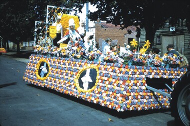
Slide - BENDIGO EASTER FAIR, 1964
Slide. Bendigo Easter Fair. The Eaglehawk Mother's Club float. Them; Easter Landslide, bendigo, bendigo easter fair., bendigo easter fair. -
 National Vietnam Veterans Museum (NVVM)
Booklet, Photocopied Book
Photocopy of 115 pages relating to land clearing & hazards. Yellowed foolscap sized paper.land clearing -
 National Vietnam Veterans Museum (NVVM)
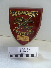
Plaque
Red veneer plaque featuring winged dragon of the Land Warfare Centre, Victoria detachmentPresented to "WO1 G. Maple (RAINF) (5 June 90 - 21 Jan 93) Best wishes S1 and staff LWC (Vic Det)plaque -
 Uniting Church Archives - Synod of Victoria
Photograph
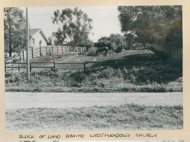
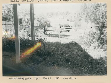
B & W gloss photograph of the land behind the Westmeadows Uniting Church Coghill Streetwestmeadows, uniting church, sunday school, toilet block -
 Uniting Church Archives - Synod of Victoria
Photograph
B & W gloss photograph of the land behind the Westmeadows Uniting Church Coghill Streetwestmeadows, uniting church, sunday school, toilet block -
 Victorian Aboriginal Corporation for Languages
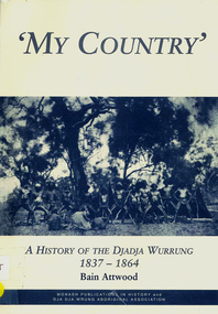
Book, Bain Attwood, 'My country' : a history of the Djadja Wurrung 1837-1864, 1999
A description of the invasion of Djadja Wurrung land in Central Victoria which began in the mid 1830s.maps, b&w illustrations, b&w photographsdjadja wurrung, dja dja wurrung, dja dja wrung aboriginal association, beembarmin, victorian pastoral leases, franklinford, fernihurst, edward parker, caroline morgan, thomas dunolly, cummeragunja, racial conflict, racism, victorian social history -
 Whitehorse Historical Society Inc.
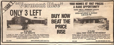
Newspaper - Advertisement, Vermont Rise, 1988
Newspaper advertisement for 'Vermont Rise', houses and land, Kara Walk, Vermont South, 1988.land sales, vermont rise, kara walk, vermont south -
 Whitehorse Historical Society Inc.
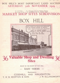
Document, Market Shop Sites subdivision, 20/11/1929 12:00:00 AM
5 pages describing sale of land in Whitehorse Road,5 pages describing sale of land in Whitehorse Road, Market Street, Box Hill5 pages describing sale of land in Whitehorse Road,land subdivision, market street, box hill, coghill & haughton, t.r.b. morton & son, ellingworth, john roger -
 Whitehorse Historical Society Inc.
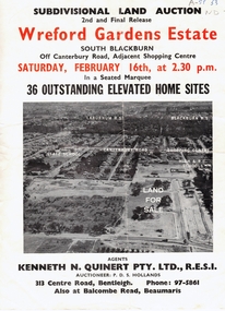
Document, Wreford Gardens Estate, 1/02/1963 12:00:00 AM
Wreford Gardens Estate,Pamphlet advertising land for sale on Wreford Gardens Estate, Blackburn 16th February, 1963Wreford Gardens Estate,land sales, wreford gardens estate, blackburn south, abercromby road, edinburgh road, baird court, barrina street -
 Whitehorse Historical Society Inc.
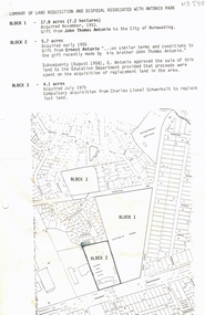
Document, Antonio Park, n.d
Summary of land acquisition and disposal associated with Antonio Park, 1953 - 1975:Summary of land acquisition and disposal associated with Antonio Park, 1953 - 1975: plans and text.Summary of land acquisition and disposal associated with Antonio Park, 1953 - 1975: antonio park, mitcham, antonio park primary school, deep creek road, edgerton road, antonio, john thomas, ernest, schwerkolt, charles lionel -
Whitehorse Historical Society Inc.
Legal record - Land Title, Certificate of title
Certificate of title to De Stoop (Aust) Pty Limited for land in Joseph Street BlackburnCertificate of title to De Stoop (Aust) Pty Limited for land in Joseph Street BlackburnCertificate of title to De Stoop (Aust) Pty Limited for land in Joseph Street Blackburnland titles, de stoop (aust) pty limited, joseph street blackburn north, vivian street blackburn north -
 Whitehorse Historical Society Inc.
Report, Abraham Rooks, ca 1870
A police report made about 1870 on land taken up in 1868 by Abraham Rooks.rooks, abraham, land settlement -
 Whitehorse Historical Society Inc.
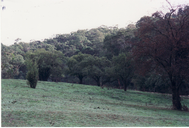
Photograph, Orchard - Schwerkolt Homestead, 24/04/2001
Original Orchard Trees planted on Schwerkolt Homestead on land abutting Schwerkolt Cottage Reserve.schwerkolt cottage, orchards -
 Whitehorse Historical Society Inc.
Photograph, Blossom Trees, 15/09/2002 12:00:00 AM
Coloured photograph of the fruit trees in blossom. These were part of the original orchard on the Schwerkolt Land.orchard, schwerkolt land -
 Rutherglen Historical Society
Image, Redmond Weller, 1950s
One of a collection of photos taken from slides by Mr Redmond Wheler, during his time as Head Master a Rutherglen State Higher Elementary SchoolColour photograph of a recently cleared block of land, possibly being cleared for an extension to a school.rutherglen schools -
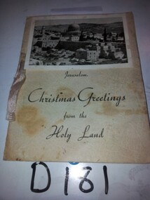 Running Rabbits Military Museum operated by the Upwey Belgrave RSL Sub Branch
Christmas Card
Christmas card from the Holy Land From A.P. Kendell VX56613 part of COL0421941, general -
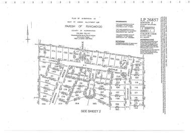 Ringwood and District Historical Society
Document - Subdivision Plan, Part of Crown Allotment 32B Parish of Ringwood, County of Mornington Vol 6051 Fol 111 - LP26857
LANDATA Land Victoria 2-sheet plan printout dated 9/11/1953.Sheet 1 includes Lynwood Avenue, Isabel Avenue, Braewood Avenue, Maple Court, and Heathwood Street, Ringwood East, Vic. Sheet 2 includes Braewood Avenue, Rotherwood Avenue, and Heathwood Street, Ringwood East, Vic. Additional markings include LP46598, CP173330, LP86847, LP213448, LP217511, LP207217, LP56241. -
 Ringwood and District Historical Society
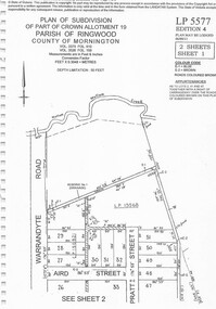
Document - Subdivision Plan, Part of Crown Allotment 19 Parish of Ringwood, County of Mornington Vol 3375 Fol 910 & Vol 3526 Fol 159 - LP5577
LANDATA Land Victoria 2-sheet plan printout dated 6/9/2011.Sheet 1 includes Warrandyte Road, Aird Street, and Pratt Street, Ringwood, Vic. Additional markings include LP19568 Sheet 2 includes Warrandyte Road, Aird Street, Pratt Street, and White Horse Road, Ringwood, Vic. Additional markings include SP25671H, CP100154, LP10519, LP28996 and P51182. -
 Ringwood and District Historical Society
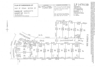
Document - Subdivision Plan, Part of Crown Section 20 Parish of Warrandyte, County of Evelyn Vol 9622 Fol 554 - LP147813B
LANDATA Land Victoria 2-sheet plan printout dated 3/12/1985.Sheet 1 includes Sandhurst Grove and Chittingstone Drive (later Braden Brae Drive) Warranwood, Vic. Sheet 2 includes Standen Court and Chittingstone Drive (later Braden Brae Drive) Warranwood, Vic. -
 Ringwood and District Historical Society
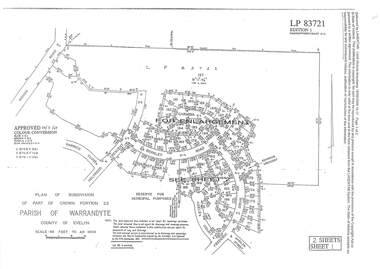
Document - Subdivision Plan, LP83721 Part of Crown Portion 23, Parish of Warrandyte, County of Evelyn, Vol 8708 Fol 351, Vol 8745 Fol 148 and Vol 8751 Fol 034 - 1969
Double sided LANDATA Land Victoria 2-sheet plan printout dated 2009Sheet 1 map and Sheet 2 enlargement including Wonga Road, Holyrood Crescent, Harwick Close, Berkley Road, Frederic Drive, Kenwood Crescent, Adele Court and Marilyn Street, Ringwood. Markings also include LP83722 . -
 Bendigo Historical Society Inc.
Archive - LAND SALES
DVD. Land Sales taken from M Drive and Gleny's Computer Two discs. -
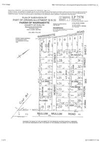 Ringwood and District Historical Society
Document - Subdivision Plan, Part of Crown Allotment 32 & 33 Parish of Warrandyte, County of Evelyn Vol 3922 Fol 242
LANDATA Land Victoria 2-sheet plan printout dated 16/6/1919.Sheet 1 includes Warrandyte Road, Hobart Street, Paxton Street, and Mullum Mullum Road, Ringwood, Vic. Additional markings include PS327701, LP215189, RP7936, LP110103, LP36735, LP31149, SP24012, PS310739, PS326740, PS336885, LP41558. Sheet 2 includes Warrandyte Road, Paxton Street, Arnold Street, and Mullum Mullum Road, Ringwood, Vic. Additional markings include RO270, SP26622, LP50242, RP19467, SP27005, SP31440, PS312181. -
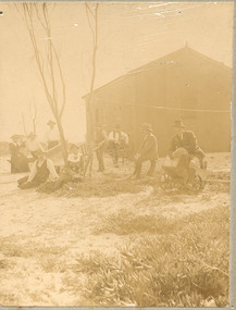 Chelsea & District Historical Society Inc
Photograph - Morton Family, After the 1913 fires in Chelsea, c 1913
Mr Alfred Morton with his sisters, brothers and friends camping at Carrum in the 1890's. This area was later called Chelsea. Alfred Louis Morton (known as Louis) was born in Geelong in 1866, the fifth of eleven children of Mark Morton and Eliza nee Heard (married 1898). Alfred began work for the Post Office at South Yarra in the 1890s. In the late 1800s it was common for people from Melbourne and north of the city to travel to Chelsea area beaches for their holidays and many liked the area so much that, like the Mortons, they moved here permanently. In the 1890s Alfred’s sister, Mrs William Ashmore, built a weekend house at the foot of what is now Foy Avenue in Chelsea. The Morton family, including Alfred, visited the area often, camping on the foreshore during the 1890s. In 1911 Alfred moved his family permanently to a house on the corner of Morton Grove and Main Road Chelsea (now known as the Nepean Highway) on property that extended from the main road to the beach. This house was destroyed in the fire of 22 December 1913 which raged amongst the ti-tree on the foreshore between Aspendale and Chelsea. Many buildings were destroyed in this fire. The Argus newspaper reported on Wednesday 24 December that 94 houses were burnt with glowing embers blown a mile and half inland. According to the Argus but for the wide break provided by the Point Nepean Road (now the Nepean Highway) and the railway line, the scrub on the other side might have caught. The Morton children, Elsa and Ivan, attended Chelsea State School (now Chelsea Primary School) and Mrs Morton was active in the establishment of St Chad’s Church of England in Chelsea. At the age of 80 in 1945 Mr Morton was concerned about reports that English children had lost their toys due to the war and so he made (as part of a wider effort in Australia) 100 toy engines that were sent to England. He died in 1946 in Chelsea.Sepia photo of members of the Morton family sitting on their land after the fires in Chelsea, 1913.morton, chelsea, carrum, verandah, fires -
 Bacchus Marsh & District Historical Society
Map, Maddingley Township, Parish of Parwan, 1880s
This map is dated Sept. 6th 1856. However places in the township of Maddingley which did not appear until the late 1880s such as the Bacchus Marsh Railway Station and line are shown on this map in their correct locations. This suggests the map has been derived from an earlier map. An earlier date of 1843 with a surveyor's name preceding it can also be seen on the map. The map is important because it indicates the location and dimensions of early but now discontinued use of land such as the showgrounds and police paddock and a site reserved for the Church of England which was not ultimately used for a permanent church. A single page paper map showing land allotments, streets, rivers, creeks, park lands, the railway line and Bacchus Marsh railway station in the township of Maddingley. The map is pasted into a bound volume containing 76 maps or plans in total. Bottom of Map: Surveyor-General's Office, Melbourne, Sept 6th, 1856bacchus marsh victoria maps, maddingley victoria maps, land use, maddingley victoria history -
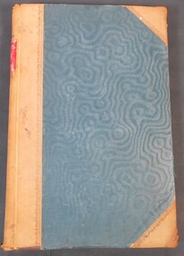 Bendigo Historical Society Inc.
Legal record - Ledger of Reports of Land Sales by Auction
Blue and light brown ledger of land sales reports during 1898 to 1924. Blue water marked cover with light brown spine and corners, with red label on spine noting "12". Contains Crown Lands sales by auction documents, including purchasers' names, land section, allotment numbers and price. Ledger of Land Sales Reports 1915 sample reports of Colbinabbin, Kyabram & Rochester.land sales, auction -
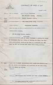 Bendigo Historical Society Inc.
Document - H. A. & S. R. WILKINSON COLLECTION: CONTRACT OF SALE
Contract of sale of land dated 25th February, 1955 between Mr. E. C. Spence (vendor) and Mr. E. K. Pipkorn (purchaser). Property: land being part of Crown allotment 8 section 19 Parish of Sandhurst, City of Bendigo being land described in deed of conveyance No. 11 book No. 567 and situate 306 White Hills Road, Bendigo, together with 5 roomed weatherboard and rough cast dwelling and all sundry buildings on said land. Also all linos and blinds. Price: 2,250 pounds.organization, business, h.a. & s.r wilkinson real estate -
 Whitehorse Historical Society Inc.
Document, Canterbury Road Tunstall, 29/01/19?5
Photocopy of letter to the Commercial Bank, Prahran re land and property valuation occupied by Mr Sliegner, north side of Canterbury Road, Tunstall (Now Forest Hill) close to Springvale Road. Land 2.5 acres with villa and out buildings.land values, sliegner (mr), canterbury road, forest hill, c. husband (estate agent) -
 City of Whittlesea
Document - Correspondence, Station Entrance and Railway Platform Estate, 1937
Letter from Ellison, Hewison & O'Collins Solicitors, Melbourne to the Shire of Whittlesea in reponse to a request for the names and addresses of the purchasers of blocks of land on the Station Entrance Estate and Railway Platform Estate, Thomastown. Both estates where originally subdived and sold in the mid 1920s. The collection includes a letter, a list of owners and their address details and the lot they own, and plans of both estates, which have been cut out of the original estate sale posters. Streets include High Street (Epping Road), Mount View Road, Pleasant Road, Central Avenue, Highlands Road and Main Street, ThomastownLetter, paper 3 pages, 2 plans. Letter from Ellison, Hewison & O'Collins Solicitors, Melbourne to the Shire of Whittlesea in reponse to a request for the names and addresses of the purchasers of blocks of land on the Station Entrance Estate and Railway Platform Estate, Thomastown. -
 Flagstaff Hill Maritime Museum and Village
Map - Survey Map, F.F. McGovern, Yangery - County of Villiers, 1884
A surveyor was employed to measure the land designated as Yangery, County of Villiers, in the Borough of Warrnambool. The area on the map is similar to the earlier Farnham Survey undertaken by William Rutledge in the 1850's. Warrnambool was a Borough between 1863-1883. Coutours, waterways, sea and other significant points are shown. The distances are accurately measured. This survey map was used for planning future land sales, recreation areas and roads. WILLIAM RUTLEDGE (1806-1876) William Rutledge surveyed the land known as Farnham in southwest Victoria in 1843. His tenants made him a profitable business from working the land there. In 1863 Rutledge moved from nearby Port Fairy to Farnham and became very successful in breeding sheep, which he imported from J.R. Kirkham of Lincolnshire, England. He also bred horses on his land. The survey map of Yangery is important for its connection with renowned surveyor William Rutledge. The map shows the growth of landholders in the district when compared to the original Rutledge survey of the 1850's.Survey map of Yangery, titled "Yangery - County of Villiers". Printed on white paper, mounted on brown paper. c. 1863-1876. Comments printed on the Map include; Special Survey by William Rutledge, Photo-lithographed at the Department of Lands and Survey, Melbourne by W.J. Burson, Price 1/- [one shilling]. Scale is in Chains. Map has boundaries of Koroit Borough, Meerai, Purnim, Wangoom, Borough of Warrnambool, Mentions the Proposal of Tower HIll for Public Recreation. The map names the owners of the land at that time. Hand written pencil marks and figures and "Sauls fence" drawn on map. Hand written pencil markes and figures and "Sauls fence" drawn onto map. "For Department Use only". "Scale: 8 chains to 1 inch" flagstaff hill, warrnambool, shipwrecked-coast, flagstaff-hill, flagstaff-hill-maritime-museum, maritime-museum, shipwreck-coast, flagstaff-hill-maritime-village, county of villiers map, yangery district, w.j. burson, borough of warrnambool, koroit, purnim, meerai, wangoom, proposal of tower hill for public recreation, special survey by william rutledge, william rutledge, farnham, lincolnshire sheep, clydesdale