Showing 3070 items matching "scales"
-
 Bendigo Historical Society Inc.
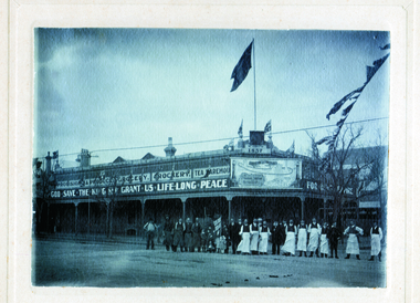
Photograph - BUSHS STORE, c1902
Black and white photograph: 'Bush's Store' Cnr Williamson & Myers Sts, Bendigo. Probably June 1902 staff during peace celebrations for the Boer War (or Coronation of King Edward VII, August 1902). Commonwealth flag, Union Jack and Australian flags visible. Map on front of store displays Australia prior to Northern Territory being formed in 1911. 2 photocopies of photograph both smaller scale. Physical description: cardboard mounted. Inscriptions/Markings: W. H. Robinson Photographer, Mundy St., Bendigo.W H Robinson, Photographer, Mundy St. Bendigo.buildings, commercial, bushs store -
 Kew Historical Society Inc
Map, MMBW, MMBW Plan No.39 Kew & Heidelberg, 1900-1910
The Melbourne and Metropolitan Board of Works (MMBW) was established by an act of the Victorian Parliament in 1890 to prepare for and to implement a sewerage and water reticulation system across what was then inner Melbourne, its surrounding and middle distance suburbs, including Kew. The MMBW was disbanded in 1991.The map collection of the Kew Historical Society has at its core the historic maps assembled and originally stored in the City Engineer's Department of the City of Kew. These include maps in a number of scales. The vast majority of maps were produced by the MMBW in the first two decades of the twentieth century, and are solid working maps, backed by linen for durability. These maps are historically significant to Kew, the City of Boroondara and to the history of the development of state utilities in Victoria. A number of the Kew maps have additional details added by former municipal officers, including the levels reached by various floods. As these were working documents, information was added to them long after the period of their initial production and distribution.Early map of part of the Borough of Kew, created in the first decade of the twentieth century, at a scale 160 ft to 1 inch. The map covers what was then the north western section of Kew, bordered on its north by Wills Street and the Kew Lunatic Asylum, in the west by the River Yarra [and the later added Yarra Boulevard] , by Princess Street in the East and Holroyd Street in the south. The map shows the extent of urban development by that time, prominent institutions and the outlines of built structures in the municipality. Contour lines were added in ink to the map at a later stage.MELBOURNE AND METROPOLITAN BOARD OF WORKS / PLAN NO. 39 / KEW & HEIDELBERGmelbourne & metropolitan board of works, mmbw maps, mmbw plans, borough of kew, cartography -
 Kew Historical Society Inc
Map, MMBW, MMBW Plan No.67 Kew, 1900-1910
The Melbourne and Metropolitan Board of Works (MMBW) was established by an act of the Victorian Parliament in 1890 to prepare for and to implement a sewerage and water reticulation system across what was then inner Melbourne, its surrounding and middle distance suburbs, including Kew. The MMBW was disbanded in 1991.The map collection of the Kew Historical Society has at its core the historic maps assembled and originally stored in the City Engineer's Department of the City of Kew. These include maps in a number of scales. The vast majority of maps were produced by the MMBW in the first two decades of the twentieth century, and are solid working maps, backed by linen for durability. These maps are historically significant to Kew, the City of Boroondara and to the history of the development of state utilities in Victoria. A number of the Kew maps have additional details added by former municipal officers, including the levels reached by various floods. As these were working documents, information was added to them long after the period of their initial production and distribution.Early map of part of the Borough of Kew, created in the first decade of the twentieth century, at a scale 160 ft to 1 inch. The map covers what was then the north central part of Kew, bordered on its north by the Outer Circle Railway Spruzen and Beresford Avenues, in the west by Princess Street, in the south by High Street, and in the east by (about) Belford Road. The map shows the extent of urban development by that time, prominent institutions and the outlines of built structures in the municipality. Contour lines were added in ink to the map at a later stage.MELBOURNE AND METROPOLITAN BOARD OF WORKS / PLAN NO. 67 / KEW melbourne & metropolitan board of works, mmbw maps, mmbw plans, borough of kew, cartography -
 Kew Historical Society Inc
Map, MMBW, MMBW Plan No.68 Kew, 1900-1910
The Melbourne and Metropolitan Board of Works (MMBW) was established by an act of the Victorian Parliament in 1890 to prepare for and to implement a sewerage and water reticulation system across what was then inner Melbourne, its surrounding and middle distance suburbs, including Kew. The MMBW was disbanded in 1991.The map collection of the Kew Historical Society has at its core the historic maps assembled and originally stored in the City Engineer's Department of the City of Kew. These include maps in a number of scales. The vast majority of maps were produced by the MMBW in the first two decades of the twentieth century, and are solid working maps, backed by linen for durability. These maps are historically significant to Kew, the City of Boroondara and to the history of the development of state utilities in Victoria. A number of the Kew maps have additional details added by former municipal officers, including the levels reached by various floods. As these were working documents, information was added to them long after the period of their initial production and distribution.Early map of part of the Borough of Kew, created in the first decade of the twentieth century, at a scale 160 ft to 1 inch. The map covers what was then the north central part of Kew, bordered in the north by Oak Avenue, in the west by the Yarra River and Connor's Creek, in the south by Beresford and Carnegie Avenues, and in the east by Glass's Creek and Burke Road. The map shows the extent of urban development by that time, prominent institutions and the outlines of built structures in the municipality. Contour lines and the levels of historic floods were added in ink to the map at a later stage.MELBOURNE AND METROPOLITAN BOARD OF WORKS / PLAN NO. 68 / KEW melbourne & metropolitan board of works, mmbw maps, mmbw plans, borough of kew, cartography -
 University of Melbourne, Burnley Campus Archives
Plan, School of Primary Agriculture & Horticulture - Burnley, c. 1925-1926
Copy of plan photographed at the Public Records Office Victoria. Central Administration Correspondence Files 1912-1939 ITEM. VPRS 10163/P0003/2. Accomodation Burnley School Part 1. Traced from M.M.B.W. Plan No. 42. Scale 160 ft=1 in. Level Datum L.M.N. Hobson's Bay. Traced by C.E.B.W. 16.02.1926. Additional matter in red and green inserted by F.E.T.C. 09.02.1926. Note by J.J. Rae (Principal). Lists W.C.s (toilets). Shows 1891 Flood Line. Possibly dates from 1925.prov, school of primary agriculture and horticulture, burnely, j.j. rae -
 University of Melbourne, Burnley Campus Archives
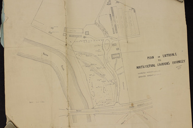
Plan, Plan of Entrance to Horticultural Gardens Burnley, 1932
Copy of plan photographed at the Public Records Office Victoria. (1) Hand drawn plan signed by A.W. Jessep 8/12/32 with 'Suspected Roadway' and ' Suggested Roadway'. Scale 1 inch - 1 chain. Trees on East side named. (2) Memorandum to The Agricultural Superintendent dated 08.12.1932 'Re Proposed Boulevard Along the River Yarra' from the Principal A.W. Jessep. Plan had been to put road through the Lagoon Paddock and he suggested the route outside the Burnley College grounds.prov, burnley gardens, a.w. jessep -
University of Melbourne, Burnley Campus Archives
Plan, New School of Primary Agriculture & Horticulture Burnley Gardens, 1945
Photocopy of Plan of the Administration Building by the Chief Architect dated 26.9.45. Scale 1/8 inch - 1 foot. Photocopy reduced in size from original. (1) Ground Floor and First Floor Plans. (2) West Elevation, Longitudinal Section 'B-B' and East Front Elevation. (3) Flat Roof, Library and Herbarium. (4) Common Room and Assembly Hall. Originally in the Burnley Archives. Property and Service now have the original and gave the reduced size photocopy to the Archives. Hard to read now.burnley gardens, school of primary agriculture and horticulture -
 Melbourne Tram Museum
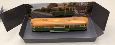
Leisure object - Model tram and presentation case, Cooee Concepts Pty Ltd, Model of Melbourne W7 1027, 2001
Model of Melbourne W7 1027 in a presentation cardboard box, made by Cooee Concepts Pty Ltd in China. Tram secured into the card box by two screws just behind the life guard. Made from plastic with trolley poles from metal (trolley poles can be moved) light brown or gold roof, green and yellow sides, black No. 15 truck The box sides provides details of the tram, scale and a photo of a tram running in the street. Box details the tram as a W6, but its number and history detail it as a W7.trams, tramways, models, cooee models, w7 class, tram 1027 -
 Melbourne Tram Museum
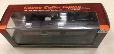
Leisure object - Model tram and presentation case, Cooee Concepts Pty Ltd, Model of ex Melbourne W6 976, in use as Bendigo "ninesevensix", c2010
Model of ex Melbourne W6 976, in use as Bendigo "ninesevensix" in a presentation cardboard box, made by Cooee Concepts Pty Ltd in China. Tram secured into the card box by two screws just behind the life guard. Made from plastic with trolley poles from metal (trolley poles can be moved) light black roof, red and gray sides, black No. 15 truck The box sides provides details of the tram, scale and a photo of a tram and its use in Bendigo firstly as a Cafe Tram then as a Restaurant Tram.trams, tramways, models, bendigo, restaurant tram, cooee models, w6 class, tram 976 -
 Bendigo Historical Society Inc.
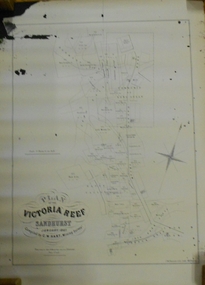
Document - MARKS COLLECTION: MAP OF VICTORIA REEF MINING CLAIMS
Copy of map. On bottom LH side: Plan of the Victoria Reef Sandhurst January 1867, Compiled by G.W. Hart, Mining Surveyor. Published by John N. Macartney, Argus Agent, Sandhurst. Price 4/- each. On bottom Rh side J.W. Pearson & Co. Lith. Melbourne Plan shows mining claims and names of holders, scale (4 chains to one inch) Loddon Road, Mount Korong Road, Ironbark Gully, township of Long Gully, Quartz Miners' Arms and Gold Mines Hotel on Loddon Road.bendigo, mining, victoria reef plan -
 Bendigo Historical Society Inc.
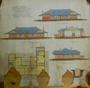
Plan - MARKS COLLECTION: ALBERT PARK SERPENTINE HOUSE PLAN FOR H. LANSELL
Laminated plan showing house plan, side and front elevations, for house plan for H. Lansell, Serpentine. Hand coloured drawings and floor plan. Edwardian style shows large house with maid's quarters, cellar, dining room, bedrooms, dressing room. On top of plan written in black pen Proposed Homestead, Albert Park, Serpentine, for H. Lansell Esq, scale eight feet to one inch, W. Beebe & G.D. Garvin, architects, late W. Beebe, Mitchell Street, Bendigo..bendigo, house, albert park, serpentine -
 Bendigo Historical Society Inc.
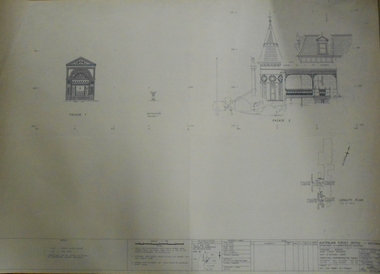
Plan - FORTUNA COLLECTION: FORTUNA VILLA
Originally built by Christopher Ballestedt (1796-1869) and his son Theodore. The Ballestedt's pioneered open cut and quartz mining on the Bendigo gold field. They were very successful. After Christopher's death, Theodore continued until 1871 when he sold Fortuna, their mines and equipment to George Lansell for 30,000 pounds.Four large plans of Fortuna villa. Scale 1:50 Australian survey office - Victoria Department of Administrative services. Fortuna Bendigo - Army Survey Regiment. Dept. of Defence - Army. Terrestrial Photogrammetric Survey. Project number: 8001/2. Reg. File: 64/531. Survey File:631. Draftsman: M.A. Osciak. Surveyed by G. Tucker. Date of Survey: 14/05/79. There are 4 large such plans in a plastic bag the measurement of the plans is approx. 115cm X 80 cm.plan, bendigo, fortuna villa -
 Geoffrey Kaye Museum of Anaesthetic History
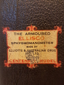
Tool - Manometer, Mercury, Elliotts & Australian Drug Pty. Ltd
In the 1600s, William Harvey realised a finite amount of blood circulates in one direction through the body. Jean Léonard Marie Poiseuille introduced the mercury hydrodynometer in the early 1800s for measuring blood pressure. Karl von-Vierordt created the sphygmograph in 1855 and, in 1881, Samuel von Basch created the sphygmomanometer, distinct improvements on the hydrodynometer. In 1896, Scipione Riva-Rocci developed the mercury sphygmomanometer. American neurosurgeon, Harvey Cushing, was an early adopter, and advocate for monitoring patients during surgery and anaesthesia. Blood pressure monitoring is still an essential component of evaluating a patient’s condition.This blood pressure kit is housed in a rectangular, vinyl covered box with metal handle and press-stud lid release mechanism. The lid opens upwards and the glass blood pressure valve and plastic scale is attached to the underside of the lid. The measurements are written in black and go up in increments of ten, from 0 to 300. The glass valve has unidentified increments labelled in red, which is housed within a metal cylinder. The bellows is attached to the measuring valve via a dark green pressure cuff and rubber hose.Blue sticker affixed inside the kit: JOHN MARUM Ornate manufacturer's label: THE ARMOURED / ELLISCO / SPHYGMOMANOMETER / MADE BY / ELLIOTTS & AUSTRALIA DRUG / [indecipherable] LTD / CENTEN[indecipherable] MODELharvey cushing, blood pressure, measurement, anaesthetics, john marum, sphygmomanometer, elliotts & australian drug pty ltd, centenary model, cuff, bellows, ellisco, armoured -
 Bendigo Historical Society Inc.
Document - MARKS COLLECTION: PARISH PLAN OF WHITE HILLS
Sepia coloured map showing allotments in Parish of Sandhurst (White Hills) Written on LH side of map town and Suburban Lots White Hills Parish of Sandhurst. Scale is shown in chains. Surveyed by Horage Walker. Photo lithographed at the Department of Lands & Survey, Melbourne by J.Noone, Price 1/-. 6th. January 1865. Map shows Race Course Reserve at top of sheet, Municipal boundary is marked on LH side. Comments re vegetation throughout map. For example, poor soil timbered with Box scrub.on the back--Plan of Land White Hills Sandhurstbendigo, planning, white hills parish map, horage walker, j noone, department of lands and survey, -
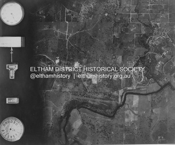 Eltham District Historical Society Inc
Photograph - Aerial Photograph, Landata, Eltham and Lower Plenty, Nov. 1931
Centred over present-day Rosehill Road and View Road, Lower Plenty Historic Aerial Imagery Source: Landata.vic.gov.au Aerial Photo Details: Project No :1931 Project : MALDON PRISON Run : 19 Frame : 3129 Date : 11/1931 Film Type : B/W Camera : F8 Flying Height : 11000 Scale : 18860 Film Number : 60 GDA2020 : 37°44'16"S, 145°07'40"E MGA2020 : 335039, 5821622 (55) Melways : 21 E11 (ed. 42)aerial photo, eltham, lower plenty, neil webster collection, rosehill road, view road -
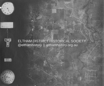 Eltham District Historical Society Inc
Photograph - Aerial Photograph, Landata, Eltham and Eltham North, Nov. 1931
Centred over present-day Opal Court and Manning Road, Eltham North Historic Aerial Imagery Source: Landata.vic.gov.au Aerial Photo Details: Project No :1931 Project : MALDON PRISON Run : 19 Frame : 3131 Date : 11/1931 Film Type : B/W Camera : F8 Flying Height : 11000 Scale : 18860 Film Number : 60 GDA2020 : 37°42'10"S, 145°08'07"E MGA2020 : 335621, 5825531 (55) Melways : 21 G2 (ed. 42)aerial photo, eltham, neil webster collection, eltham north, manning road, opal court -
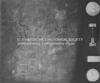 Eltham District Historical Society Inc
Photograph - Aerial Photograph, Landata, Eltham and Eltham East, Nov. 1931
Centred over present-day Beard Street bewteen Park Road and Main Road, Eltham East Historic Aerial Imagery Source: Landata.vic.gov.au Aerial Photo Details: Project No :1931 Project : MALDON PRISON Run : 20 Frame : 3135 Date : 11/1931 Film Type : B/W Camera : F8 Flying Height : 11000 Scale : 18860 Film Number : 60 GDA2020 : 37°42'16"S, 145°09'41"E MGA2020 : 337912, 5825386 (55) Melways : 22 B2 (ed. 42)aerial photo, eltham, neil webster collection, beard street, eltham east, main road, park road -
 Eltham District Historical Society Inc
Photograph - Aerial Photograph, Landata, Eltham, Nov. 1931
Centred over present-day Laleham Court between Arthur Street and Hartland Way, Eltham Historic Aerial Imagery Source: Landata.vic.gov.au Aerial Photo Details: Project No :1931 Project : MALDON PRISON Run : 20 Frame : 3136 Date : 11/1931 Film Type : B/W Camera : F8 Flying Height : 11000 Scale : 18860 Film Number : 60 GDA2020 : 37°42'56"S, 145°09'33"E MGA2020 : 337759, 5824139 (55) Melways : 22 B5 (ed. 42) aerial photo, eltham, neil webster collection, arthur street, hartland way, laleham court -
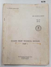 Bendigo Military Museum
Manual - Shaded Relief Technical Manual - United States Air Force, Department of the Air Force, USA, May 1958
This manual describes how to hand create "Shaded Relief" or the appearance of hills. This manual was produced by the Aeronautical Chart Information Centre, United States Air Force, St Louis 18, Missouri. Shaded relief was produced by hand at the Army Survey Regiment in the 50's, 60's and 70's so that it could be shown on small scale topographical maps and RAAF Aeronauical Charts. Shaded relief continued to be produced by hand until the mid 1980's when it was replaced by digital production methods.Grey covered Manual, gloss paper, stapled together.royal australian survey corps, rasvy, fortuna, army survey regiment, army svy regt, asr -
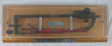 Federation University Historical Collection
Tool, British Oxygen Company Ltd, Oxy-cutting and Welding Blow Pipes, c 1904
In 1903 the oxyacetylene welding process was developed. Around the same time, new cryogenic air separation processes, based on work undertaken by Carl von Linde and others, replaced the barium oxide process. This paved the way for larger scale and more efficient production. British Oxygen Company, [1905 to 1969] was formally BRIN'S Oxygen Company Ltd from 1886 to 1905. In 1969 it became BOC. These Blowpipes were used at the Ballarat School of Mine c1916 Interesting article = 1917. https://trove.nla.gov.au/newspaper/article/1629321Boxed Universal Blow Pipe, presented under a perspex top. Pipes mounted by metal bar and hooks to polished wooden board. Display case is 69.0cm x 12.0cm x 25.0cmBoth pipes have metal plates indicating information of maker.blowpipes, ocyacetylene, ballarat school of mines, welding, cutting, commonwealth industrial gases, boc, brin's oxygen company, british oxygen company -
 Robin Boyd Foundation
Functional object - Bookends
Boyd designed the exhibition for the opening of the Australian Chancery in Washington DC held in June 1969. He designed six cylindrical clear acrylic display cases. One of these exhibits used an anamorphic optical illusion, using compressed images which had normal proportions when viewed through a lens of the half-cylindrical display cases. These bookends were designed as a small scale model for the Chancery exhibition. Placing the disc (item F158) underneath the adjacent two half-cylindrical bookends demonstrates how the bookends behave as a lens.Two half cylindrical acrylic prismsaustralian chancery, walsh st furnishings, robin boyd, ohm2022, ohm2022_3 -
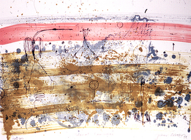 Nillumbik Shire Council
Print (Lithograph): John Olsen (b.1928 NSW), John Olsen, Tropical Rain Shower from The Bodford Terrace Suite, 1978
A typical Olsen painting combines an implied aerial view with an ambiguous and seemingly unpremeditated figuration. His characteristically quizzical line and irregular squiggles and dots deftly render countless organisms, large and minute. Their environment is conjured through loosely brushed and stained expanses of colour (on canvas or hardboard) and lines which sometimes read as geological mappings. In Olsen's work there is no foreground/ middle ground/ background, nor any sign of European landscape's concern with "human scale." Instead he employs simultaneously the contrary vantages of naturalist and geographer. 'Tropical Rain Shower' by John Olsen forms one of the eight artworks represented in the Bodford Terrace Suite. Eight of Australia's finest artists were brought together to create a folio of lithographic prints to celebrate the restoration of historic Bodford Terrace. Printed at the Druckma Press by John Robinson under the supervision of master printer Jock Abbott. The folio edition was limited to 300 signed and numbered folios. The lithographs were printed on special heavy weight french Arche's paper in accordance with the tradition of this artistic medium. Lithographic print on paper.Signed John Olsen '78, lower right hand corner. Edition 179/300bodfford terrace collection, john olsen, tropical rain shower -
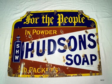 Flagstaff Hill Maritime Museum and Village
Sign - Hudson's Soap Enamel Advertising Sign, Patent Enamel Co Ltd, c. late 19th century- early 20th century
Hudson's Soap Powder, was the first satisfactory and commercially successful soap powder and was made in Liverpool by Robert Spear Hudson. He was also an innovator in using advertising, commissioning striking images from professional artists and paid for publicity , something which few other businesses did, and as such Hudson's soap became a household name. Horse, steam and electric tramcars, print periodicals and chemist shops carried his advertisements. This sign was manufactured by Patent Enamel Co Ltd was a company built in 1889 at Selly Oak, Borough of Birmingham, West Midlands, England, United Kingdom. The business was the first factory specifically devoted to enameled iron sign making. It had twelve furnaces for fusing the enamel, two scaling furnaces, and a large printing room, plus a huge area for steampipe drying. The company also smelted its own enamels and colour oxides. It is believed that the factory was decommissioned and demolished in the 1960's.the first factory specifically devoted to enameled iron sign making. It had twelve furnaces for fusing the enamel, two scaling furnaces, and a large printing room, plus a huge area for steampipe drying. The company also smelted its own enamels and colour oxides.The factory was decommissioned and demolished in the 1960s.The signage demonstrates the increasing demand for domestic soap products and new forms of advertising. The soap business was apart of the flourishing export trade between Australia and Britain during the height of the British Empire.Enamel advertising sign for Hudson's soapflagstaff hill, warrnambool, maritime museum, hudson's soap, advertising signage, patent enamel co ltd, selly oak, borough of birmingham, robert spear hudson -
 Eltham District Historical Society Inc
Photograph - Aerial Photograph, Landata, Eltham, Luck St; Bible St to Beard St, Dec. 1945
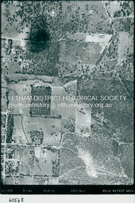
Centred on present day Eltham East Primary School, east of Main Rd along Luck St to Beard St Historic Aerial Imagery Source: Landata.vic.gov.au Aerial Photo Details: Project No :5 Project : MELBOURNE AND METROPOLITAN AREA PROJECT Run : 36 Frame : 60548 Date : 12/1945 Film Type : B/W Camera : EAG4 Flying Height : 10200 Scale : 6000 Film Number : 195 GDA2020 : 37°42'46"S, 145°09'18"E MGA2020 : 337371, 5824456 (55) Melways : 22 A4 (ed. 42)aerial photo, eltham, arthur street, beard street, bible street, eltham east primary school, frank street, henry street, luck street, stanley avenue, wycliffe crescent, neil webster collection -
 Eltham District Historical Society Inc
Photograph - Aerial Photograph, Landata, Eltham, Main Rd; Railway Rd to Zig Zag Rd, Dec. 1945
Centred on present day Edendale Farm from Glen Park rd to Zig Zag Rd Historic Aerial Imagery Source: Landata.vic.gov.au Aerial Photo Details: Project No :5 Project : MELBOURNE AND METROPOLITAN AREA PROJECT Run : 37 Frame : 60549 Date : 12/1945 Film Type : B/W Camera : EAG4 Flying Height : 10200 Scale : 6000 Film Number : 196 GDA2020 : 37°42'12"S, 145°09'09"E MGA2020 : 337141, 5825486 (55) Melways : 21 K2 (ed. 42)aerial photo, eltham, edendale farm, eltham - yarra glen road, eltham-hurstbridge railway line, gastons homestead, gastons road, glen park road, main road, park road, railway road, wattletree road, zig zag road, neil webster collection -
 Eltham District Historical Society Inc
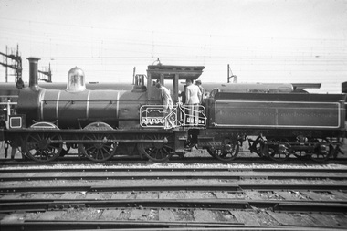
Photograph, George Coop, Steam locomotive T-94 on display at Spencer Street Railway Station during the 1954 Victorian Railways Centenary Exhibition, Sep. 1954
Steam locomotive T-94 has been preserved and is currently on display at the Australian Railway Historical Society Museum at North Williamstown http://www.australiansteam.com/T%2094.htm "V.R. Cavalcade" Centenary 1854-1954 Exhibition (11-25 Sep 1954) presented a model railway occupying about 1,400 square feet in the Lower Town Hall featuring a number of model railway working scale models. The exhibition also included a display of rolling stock, track, electrical and other railway equipment held at Spencer Street Railway Station.Digital TIFF file Scan of Kopdak 620 black and white negative transparencygeorge coop collection, display, spencer street railway station, v.r. cavalcade, victorian railways centenary 1854-1954 exhibition, t-94, t-class steam locomotive -
 Eltham District Historical Society Inc
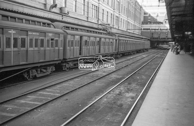
Photograph, George Coop, View of Tait Red Rattler at No. 1 Platform, Flinders Street Railway Station, Sep. 1954
Most likjely taken either arriving or departing from a visit of the display at Spencer Street Railway Station during the 1954 Victorian Railways Centenary Exhibition, 11-25 Sep. 1954 "V.R. Cavalcade" Centenary 1854-1954 Exhibition (11-25 Sep 1954) presented a model railway occupying about 1,400 square feet in the Lower Town Hall featuring a number of model railway working scale models. The exhibition also included a display of rolling stock, track, electrical and other railway equipment held at Spencer Street Railway Station.Digital TIFF file Scan of Kopdak 620 black and white negative transparencygeorge coop collection, v.r. cavalcade, victorian railways centenary 1854-1954 exhibition, red rattler, tait train -
 Women's Art Register
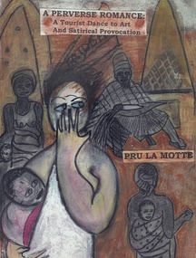
Book - Novel, Pru La Motte, A Perverse Romance. A Tourist Dance to Art and Satirical Provocation, 2017
A satirical illustrated tale of artist Hephzibah Brown who is persuaded by Cedric the Imp of Perversity to follow him to the recently independent Ghana to compose a tourist book he will write and she illustrate. She follows him but changes it to a novel about two tourists, one pragmatic and one an idealistic, a woman, to examine "real life'' being a form of transience.fictionA satirical illustrated tale of artist Hephzibah Brown who is persuaded by Cedric the Imp of Perversity to follow him to the recently independent Ghana to compose a tourist book he will write and she illustrate. She follows him but changes it to a novel about two tourists, one pragmatic and one an idealistic, a woman, to examine "real life'' being a form of transience.collage, drawing, travelogue, weaving, sexuality, satire, writing -
 Robin Boyd Foundation
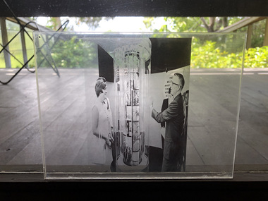
Photograph - Transparency
Boyd designed the exhibition for the opening of the Australian Chancery in Washington DC held in June 1969. He designed six cylindrical clear acrylic display cases. One of these exhibits used an anamorphic optical illusion, using compressed images which had normal proportions when viewed through a lens of the half-cylindrical display cases. The bookends (item F157) were designed as a small scale model for the Chancery exhibition. Placing the disc (item F158) underneath the adjacent two half-cylindrical bookends (item F157) demonstrates how the bookends behave as a lens.Photocopy of a image on a transparencyaustralian chancery, robin boyd -
Vision Australia
Administrative record - Text, The Association for the Blind Illawarra Community Centre manager reports 7/11/1978 to 6/6/1993, 1978-1993
The Manager reports are a general overview of the activities, programs, statistics, personnel, policies, repairs, volunteers and updates of the Illawarra Community Centre. The newsletter from Geelong Branch committee is also been included. 3/9/1979 it was reported that after receiving written permission the Geelong Advertiser, sections of the paper have been recorded onto cassette, on a weekly basis, and made available to low vision members. 7/7/1980 it was reported that a detailed scale model of Illawarra has been constructed as an aid to assist visually and other handicapped members to become orientated to the Centre. 1 paper register of handwritten notesassociation for the blind, illawarra community centre