Showing 1988 items matching "victoria bridge"
-
 Lakes Entrance Historical Society
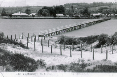
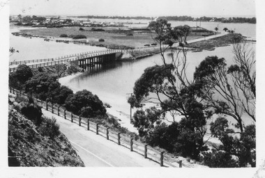
Photograph - Footbridge, 1937c
Two other copies 6.5 x 9 imageBlack and white photograph showing waterfront, Esplanade, some buildings and background hill almost completed footbridge across Cunninghame Arm. Posts defining pathway over sand dune to ocean beach. Lakes Entrance VictoriaFootbridge to Ocean Beach, Lakes Entrancewaterways, bridges, township -
 Lakes Entrance Historical Society
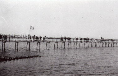
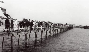
Photograph - Footbridge, Jemmeson Edie, 1937
Also second copyBlack and white photograph of the completed footbridge over the Cunninghame Arm,showing Lifesavers from Melbourne clubs leading the way across the bridge after the official opening. Lakes Entrance Victoriabridges, celebration -
 Lakes Entrance Historical Society
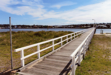
Photograph - Footbridge, 2008
Date made August 2008|This is the paired after photograph used in the 150 year Lakes Entrance 1858 - 2008 display.Colour photograph of the footbridge crossing Cunninghame Arm waterway, the township is in the foreground, Lakes Entrance, Victoria.bridges, waterways, township -
 Lakes Entrance Historical Society
Photograph - Footbridge, 1927
Official opening 27 March 1927Black and white photograph of the footbridge over the Cunninghame Arm, showing a crowd of people following the Melbourne Lifesavers crossing the bridge after the official opening, Lakes Entrance Victoriawaterfront, bridges, celebration -
 Lakes Entrance Historical Society
Postcard - Bullock Island, 1935c
Also faded postcard same imageBlack and white small format postcard of the Princes Highway as it winds around Jemmys Point. It shows the North Arm bridge, narrow bridge to Bullock Island, glimpse of the western part of town, hummocks of southern shore of Cunninghame Arm. Lakes Entrance VictoriaLakes Entrancefences, roads and streets, islands -
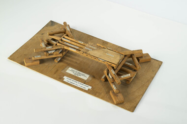 Department of Energy, Environment and Climate Action
Scale model of single lane timber bridge
... Commission Victoria (FCV) Road and Bridge construction Engineering ...The Forests Commission had a large engineering branch that assisted districts with road construction works This scale model (with engineering calculations) was used to assist in the design and construction of commonly used timber bridges This model comes from Orbost Last remaining model known. Most crossings are now either concrete culverts or steel and concrete bridge spansModel timber bridge showing elements 1:50 scale for 10 metre spanforests commission victoria (fcv), road and bridge construction, engineering -
 Ballarat Tramway Museum
Slide - Set of 6, Warren Doubleday, Ballarat - last Saturday of full operations, 21/8/1971
Photos taken on the last Saturday of full operations by the SECV in Ballarat prior to the first closure of the Victoria St line on 22/8/1971. 1 - Tram 32 Drummond St North with Hospital behind. 2 - Tram 33 passing a Licensed grocer in Lydiard St North. 3 - Trams 27 and 33 Lydiard St North with the Railway Hotel, Cuthbert's solicitors offices, Norman J Ford with a Griffiths Tea and McAlpine flour adverts, and a commercial college in the background. 4 - Tram 33 on the Lydiard St level crossing while the down pass awaits with S305 5 - Tram 11 waits for S305 to pass through the level crossing. 6 - S302 and S300 on up interstate goods with the new highway overpass bridge being constructed.Yields information about the last full Saturday of SEC Tramway operations in Ballarat and has a strong association with the archivist. Set of 6 Kodachrome colour slides - cardboard mountsHave the photographer's slide numbers written on them.trams, tramways, closure, tram 32, tram 33, tram 27, level crossing, lydiard st north, tram 11, railways -
 Falls Creek Historical Society
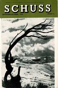
Journal - Schuss Vol. 20. No. 7 September - October 1954
Schuss was advertised as Victoria’s Official Ski Journal It was issued monthly from 1935 to 1961 except during the war when summer issues covered two months. This continued after the war, but it averaged 10 issues annually over its 25 year life. Schuss was published by the Ski Club of Victoria which had a membership of 38 Ski Clubs and demanded to be recognised as the prime authority on skiing in the state. The other 30 ski clubs with 85% of the members disagreed and the politics of skiing became heated. These clubs formed the Federation of Victorian Ski Clubs with their own journal, Ski Horizon. With the establishment of the Victorian Ski Association, Ski-Horizon published its last issue in Nov - Dec. 1955 and the role of the official journal was fully taken over by “Schuss”. This item is significant because it contains stories, images and information documenting the development of the ski industry in Victoria.The journal features stories and events chronicling developments in Victoria and internationally. Items related to the Falls Creek Area in this issue include:- Cover - Features a photo of Skeleton Snowgum at Mt. Hotham Page 233 - Lower image taken by W. L. Godfrey "On the slope of Mt. McKay, Bogong High Plains, showing Mt. Bogong in the background." Page 234 Top image Photo: H. S. Gibbs On the road to Falls Creek, Mt. Arthur in the background. Lower image: Photo- L. Coote SYDNEY HARBOUR BRIDGE, ROCKEY VALLEY, BOGONG HIGH PLAINS. This structure, well known to skiers who frequent the Plains, has now collapsed, having succumbed to the ravages of many years of use. The structure was erected by Joe Holston with the aid of a few simple tools. It's rustic craftsmanship has always been admired and served to remind skiers of the kindliness and good nature of Joe, who befriended many skiers who visited the High Plains in past years.schuss journal, the ski club of victoria, mt kckay, bogong high plains -
 Lakes Entrance Historical Society
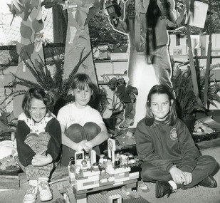
Photograph - Lakes Entrance Primary School, Lakes Post Newspaper, 1994
... bridge Lakes Entrance Victoria.... McKenzie, making a Lego bridge Lakes Entrance Victoria. Photograph ...Black and white photograph of primary school students Aleisha Burnett, Melanie McPhee and Megan McKenzie, making a Lego bridge Lakes Entrance Victoria.schools, activities -
 Lakes Entrance Historical Society
Photograph, 2012
Date made December 2012Colour photograph of the railway bridge over Boggy Creek at Nowa Nowa. Bridge is built on combination of solid concrete piers, timber trestle piers on concrete to flood level, and timber piers. Nowa Nowa Victoriabridges, waterways, transport -
 Lakes Entrance Historical Society
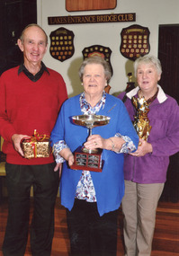
Photograph - Bridge Club Lakes Entrance Victoria, Lakes Post Newspaper, 2014
... Bridge Club Lakes Entrance Victoria... Photograph Bridge Club Lakes Entrance Victoria Lakes Post Newspaper ...Colour photograph of Shirley Hancock holding the Lakes Entrance Bridge Club Perpetual Trophy flanked by Bill and Heather Cornwall winners of the Hancock Trophy 2014bridge, recreation -
 Lakes Entrance Historical Society
Photograph - Bridge Club Lakes Entrance Victoria, Lakes Post Newspaper, 2012
... Bridge Club Lakes Entrance Victoria... Trophy 2012. Lakes Entrance Victoria Photograph Bridge Club Lakes ...Colour photograph of Shirley Hancock holding the Lakes Entrance Bridge Clubs Perpetual Trophy flanked by Barrie Martin and Dawn Wallace winners of the Hancock Perpetual Trophy 2012. Lakes Entrance Victoriabridge, recreation -
 Federation University Art Collection
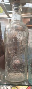
Photograph, R. Mosley Mineral Water Bottle
Robert Mosely was an aerated water and cordial manufacturer. in 1909 Robert Mosley married Isabel Ethel Shepherd Stevens (or Steens). (Victorian Marriage Records, 1909) He died in 1936. MOSLEY. - On the 28th June at a private hospital, Melbourne, Robert, the dearly loved husband of Ethel Mosley, of 31 Ormond road, Moonee Ponds, loving father of Florrie (Mrs. Bayne), Jane, and Bessie (Mrs. Read), loving stepfather of Gladys (Mrs Myers) and Esma Campion, aged 75 years. — At rest. (The Argus, 29 June 1936) MOSLEY. — On the 28th June, at a private hospital, Melbourne, Robert Mosley, of 31 Ormond-road, Moonee Ponds. At rest. (The Age, 29 June 1936)Glass bottle made for Robert Mosely of Flemington Bridge, Melbourne. The 1896 Mosley bottles was manufactured in England and Victoria (t Mr Corfield's in Exhibition Street, Melbourne. )r. mosley, robert mosley, mineral water, flemington, globe mineral water works, flemington bridge -
 Lakes Entrance Historical Society
Photograph, 1999
... by Marine Parade and the highway approach to North Arm Bridge, Lakes... to North Arm Bridge, Lakes Entrance, Victoria. Photograph ...In late 1958 bore put down in an attempt to obtain good quality water for a reticulated town water supply. Water unsuitable, but during drought years when water supply from Nicholson River was restricted, water from this bore available for public use. Bore plugged, structure removed December 2000. Site marked with plaque March 2001, by Lakes Entrance Historical Society.Colour photograph of the head works including feed pipe of water bore sunk in late 1958 on the Public Reserve bound by Marine Parade and the highway approach to North Arm Bridge, Lakes Entrance, Victoria.water supply, public utilities -
 Federation University Historical Collection
Document, Ken Clements, Peterborough Puzzles, 2009, 2009
Massacre Bay is located on Victoria's Great Ocean Road, and is in the centre of the Bay of Martyrs. The bay consists of 20 m high, red limestone bluffs. This paper by Ken Clements considers the origin of the term martyr in connection to this location, and where the Aboriginal massacre may have taken place. Thirteen page document by Ken Clements relating to Peterborough, Victoria. Contents include coastal features, local Aborigines, Bay of Martyrs, Massacre Bay, Massacre Hill, Buckley Creek Run, Pioneer Pastoralists, British Traversers, settlers, Peterborough, Maps, tourism, history method. Photographs by Laurie Moore.aborigines, bay of martyrs, massacre bay, massacre hill, buckley creek run, pioneer pastoralists, british traversers, settlers, peterborough, maps, tourism, history method, childers cove, barque children, murnane bay, sandy bay, dog trap bay, buckley creek, viviennes lookeout, stanhope bay, buttres bay, burnies beach, armstrong creek, flaxman hill, antares rock, lovers nook, crofts bay, clements, worm bay, halladale point, the well, wold dog cove, james irvine monument, curdies inlet, squirrel creek, wallaby creek, boggy creek, whiskey creek, pioneer beach, schomberg rock, young australia, spit, crown of thorns, newfield bay, the grotto, london bridge, point hesse, high cliffs, the arch, cape martyr, little massacre bay, aboriginal massacre, ken clements -
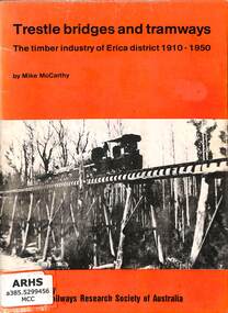 Victorian Railway History Library
Booklet, McCarthy, Mike, Trestle bridges and tramways: The timber industry of Erica district 1910-1950, 1983
A brief history of the narrow gauge timber railways of the Erica District north of Moe in Victoria from 1910 to 1950.ill, maps, p.24.non-fictionA brief history of the narrow gauge timber railways of the Erica District north of Moe in Victoria from 1910 to 1950.timber tramways - australia - history, narrow gauge railroads - australia - history -
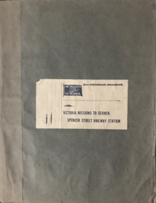 Mission to Seafarers Victoria
Book (Item) - Scrapbook, Edith E Hitchcock, Victoria Missions to Seamen, Spencer Street Railway Station, 1931-1943
The scrapbook, compiled by Edith E Hitchcock, displays a variety of newspaper clippings with photographs relating to ships, sailors, their hobbies, Padre Oliver. Page 1 - Map of the British Empire Page 3 - Newspaper clipping with photographs: "Happy Sailors Lads" onboard the CB Pedersen C.1935 Page 5 - Photograph depicting three children watching of a ship at sea Page 7 - 1937: article: with photograph"Sea Captain and Artist": Captain A.C.G. Dreillek, Swedish ship Yngaren (similar photo published in 1937 in the Courier Mail Brisbane) Page 9 - 1935: "Reunited": Dog Patsy with ship Pegasus crew members / "Sydney Harbour Bridge": Phillip Vanderhill, Cook of the Kota Inter and its sitar creation Page 11: Mr G. Gatty and Tim, the cat from the Esperance Bay / Herbert the hen, pet on the ship King Arthur / Frank Simpson, quartermaster and painter from the ship City of Dieppe. Page 13: Conway Seymour and shipmate aboard the Orford. Page 15: 3 photographs of French sailors from the cruiser Rigault de Grenouilly in 1936. Page 16: Photograph of A.J. Kramer working on a ship model aboard the Dutch ship, Kota Inten. Page 17: 1936: Photographs of sailors from the French ship Rigault de Grenouilly and the American ship: California State berthed in Prince's Pier. (plus two large loose clippings with portraits of same sailors). Page 18: 1934: Ball on the Manunda to raise funds for the Mission: photograph of Captain Robert Sunter, Padre Oliver, Moira Oliver, Mrs Harold Clapp. Page 19: Photograph of French sailors from the Rigault de Grenouilly in a bus en route to the Dandenong Ranges. Page 21: Photographs of a shipwreck (probably Kakariki in 1938, see next page). Page 23: Aerial photograph of the shipwreck Kakariki in Hobson's Bay in 1937 Page 25: Photograph of the shipwreck Kakariki in Hobson's Bay in 1937. Page 26: Photograph of the shipwreck Kakariki in Hobson's Bay in 1937. Page 27: Photograph of the survivors from the shipwreck Kakariki in the Mission in 1937: A. Bunyard, W. Fisk, J. Greene, L. Tarlington, J. McInnes, G. Coote, G. Sugar. Page 28: Photograph of the survivors from the shipwreck Kakariki in the Caradale in 1937: W. Fisk, T.W. White. Page 29: Missioneers talk to Firemen: Padre Oliver and his assistant, L.V. Owen talking to ship's firemen.(the Argus, 24 July 1931) Page 31: 3 articles with photographs: American cadets from the California State / Governor's Surprise Visit: Lord Huntingfield visiting Padre Oliver in the Mission (the Argus, 19 May 1936) / Sea Scouts on Liner: Padre Oliver on the P&O Cathay (the Argus, 16 June 1936) Page 33: Harbour Lights: padre Oliver, Lord Somers and Rev. R. Kerdell / Visit of the Duchess to the Mission (the Argus, 26 february 1945). Page 34: Photograph titled "An old salt still yearns for the sea- 369 miles away". Page 35: two clippings : Presentation of cheques for Merchant Navy: Betty Raymond giving a cheque to Padre L.L. Elliott / A cheque for the Seamen's Mission: Photograph of Padre Oliver with a cheque. Page 37: 4 clippings with photographs: Padre Oliver playing the piano for the cadets of the C.B. Pedersen / Miss Gladys Grant with parcels (from the Age 10 November 1943) / All Nations' Dance / Christmas at the Flinders Street mission, Padre Oliver cutting the cake (The Age, 15 December 1942) Page 39: Unveiling of the Memorial window to Captain Robert Sunter in 1936. Page 41: 2 clippings: At the Seamen's Mission: photographs of J. W. Neill and Padre Oliver / Married: Albert Robertson and Beryl Landrigan / Postcard of the St Peter Chapel. Page 43: 2 postcards: The Cloisters / The Mission view from Flinders Street. Page 45: Postcard of the windvane. / clipping of Sailors from the Zealandic. Page 46: 2 clippings: Virtually a Man without a country: Frans Nobel on the ship Milleeta / Seaman, Soldier, Waiter, Singer, Cook Finds Peace (Frans Nobel).(1939) Page 47: That Land Looks Good: two seamen from the tanker British Fame Page 48: large clipping of the C.B. Pedersen "Like a page from the past".(april-May 1935) Page 49: Photograph of Padre Oliver in his army uniform.This scrapbook is significant because it makes reference to contemporaneous events related to the Mission to Seafarers. On the inside cover is the name Edith E. Hitchcock.edith e. hitchcock, scrapbooks, c.b. pedersen, hobbies, ship models, painting, frank leslie oliver, mv manunda, captain robert sunter, windvane, rigault de genouilly, french, german, california, kakariki, ship pegasus, sydney harbour bridge, sugar, kota inten, philip vanderhill, lord somers, reverend r. kerdell, r.m.s. moldavia, victoria dock, ww2, pets, bird, dog, cat, gladys grant, alphonse polo, eugene emonin, raoul gannson, esperance bay, g. gatty, captain a. macwhirter, frank simpson, city of dieppe, conway seymour, orford, a.j. kramer, dutch, moira bird oliver (nee good), mrs harold clapp, caradale, 3uz radio, betty raymond, l.l. elliott, j.h. bustard, merchant navy patriotic fund, g.h. martin, j.w. neill, albert robertson, beryl landrigan, zealandic, frans nobel, milleeta, british fame -
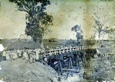 Bendigo Historical Society Inc.
Photograph - AXEDALE BRIDGE
Sepia photograph. Wooden bridge over dry creek ( possibly Campaspe or Axe Creek ?) Dead trees lying in creek. Large group of people, men women and children on bridge. Horse and vehicle at CR. Haystack in centre with stock yards. Inscriptions: On back - in pencil 'Mrs Harris Axedale 21/-' Circular stamp and 1/2 circular stamp 'Royal Historical Society of Victoria, Bendigo Branch'. Pencil note front BR - indecipherable. History: Prev. Acc. No. MP211 Research indicates that this is the bridge over Axe Creek, on the Sugarloaf Road, Axedale. The property in the background belonged to Jonathan and Harriet Harris.place, landscape view -
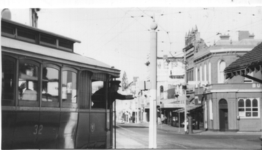 Ballarat Tramway Museum
Photograph - Grenville St signal switch, Keith Kings, 12/4/1958
Photograph shows the motorman of tram 32 selecting the correct signal light for his passage into Bridge St to either the Victoria St or Mt Pleasant Routes. Also allowed the tram to shunt at the intersection and return along Sturt St. See page 44 of the photographer's book, The Ballarat Tramways published in Sept. 1971 - item 114. Has the Buckshead Hotel in the background. Dated 12/4/1958. Yields information about the operation of the Bridge St / Grenville St signal.Black and white photograph with photographers details and information on rear - Keith Kings No. A(l)(13)See image 2ballarat, trams, tramways, sturt st, bridge st, tram 32, signals, forest city signals, grenville st -
 Wodonga & District Historical Society Inc
Photograph - Bethanga Bridge
... of a bridge which links Victoria and New South Wales and has been ...The Bethanga Bridge was built between 1927 and 1930 as a joint venture between Victoria and New South Wales and was a key element of the River Murray Waters Agreement. It consists of nine spans of 82 metres long. Each span is supported between double reinforced concrete pylons and a riveted steel camel back Pratt truss. The overall span of the bridge is a length of 752 metres. It was completed in 1929 at a cost of £194,000. The road deck was initially constructed from timber but was replaced in 1961 with a concrete waffle slab deck 7.7metres wide. In 1961 the bridge deck and truss structure were raised 300 millimetres to allow for the enlargement of the lake. The bridge was designed in NSW by road engineer Percy Alan and the trusses were built by the Charles Ruwolt Pty. Ltd. Charles Ruwolt Pty. Ltd. was originally established by Charles Ruwolt as a foundry at Wangaratta in 1902 and transferred its operations to Richmond, Melbourne in 1914. By 1938 it had become one of the biggest engineering companies in Australia. After Charles Ruwolt’s death in 1946, Vickers Ltd. acquired the company and in 1948 the firm became known as Vickers Ruwolt Pty. Ltd. Because of the Bethanga Bridge’s unique location, over the waters of a dam with the border running down the centre of the body of water, the Bethanga Bridge is the only built structure shared by both Victoria and New South Wales. As the border of New South Wales aligns with the southern bank of the Murray River all of the other bridges along its length are deemed to be in New South Wales. The Bethanga Bridge is listed on both the New South Wales State Heritage Register and the Victorian Heritage Database. In 2015 the Bethanga Bridge was nominated for a heritage award by the Institution of Engineering Australia.These images are significant because they document the construction of a bridge which links Victoria and New South Wales and has been recognised for its historical, technical and engineering significance.A collection of photos documenting the construction of the Bethanga Bridge which links the States of Victoria and New South Wales as part of the construction of the Hume Dam .bethanga bridge, hume dam constuction, charles ruwolt, percy allan engineer -
 University of Melbourne, Burnley Campus Archives
Newspaper - Newspaper Cutting, The Argus, The Horticultural Society of Victoria, 1869
Copy of article in "The Argus" 13 October, 1869. Description of entering the Gardens from Bridge Road and what could be seen of the new West Orchard, the Ornamental Gardens and the Proving Ground.the argus, gardens, west orchard, ornamental gardens, proving ground, fruit trees -
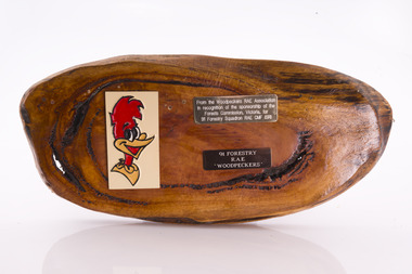 Forests Commission Retired Personnel Association (FCRPA)
Presentation plaque from the "Woodpeckers"
In the post-war era from 1947 to the mid-1980s, the Forests Commission sponsored Australia's only military sawmilling unit, the 91 Forestry Squadron. It was a special reserve unit of the Royal Australian Engineers (RAE). Established and commanded by Commission forester and WW2 veteran, Major Ben Benallack, the "Woodpeckers" as they were known comprised a small pool of specialised soldiers capable of rapid mobilisation in the event of need. Several other Victorian departments such as the State Electricity Commission (SEC) did the same thing who supported a construction squadron based at Newborough in the Latrobe Valley. The scheme created a very active and capable part-time military group that completed many worthy projects across the State. In addition to their military training, the Woodpeckers operated bush sawmills, built timber bridges along the Murray River, the Snake Island Jetty, forest roads and performed various demolition tasks.Presentation plaque from the "Woodpeckers" Mounted on polished wooden burl forests commission victoria (fcv) -
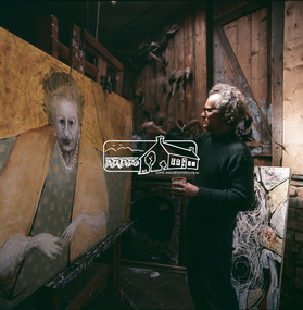 Eltham District Historical Society Inc
Photograph, Clifton Pugh - Dunmoochin, Cottles Bridge
A series of photos of Pugh at work. Clifton Pugh (1924-1990) was born at Richmond Victoria, and educated at various schools including Briar Hill Primary, Eltham Higher Elementary School and Ivanhoe Grammar. He studied art at the National Gallery School of Victoria 1948-52. Pugh is recognised as a one of Australia’s foremost painters. He is represented in major galleries throughout the country and overseas. He founded the “Dunmoochin” artists colony at Cottles Bridge. This front image from "Pioneers and Painters: 100 years of the Shire of Eltham" by Alan Marshall, page 128 shows Pugh working on his portrait of Dame Mabel Balcombe Brookes (1890-1975). According to an entry in the Australian Dictionary of Biography for Dame Brookes, this Pugh portrait remains in the family. This photo forms part of a collection of photographs gathered by the Shire of Eltham for their centenary project book, "Pioneers and Painters: 100 years of the Shire of Eltham" by Alan Marshall (1971). The collection of over 500 images is held in partnership between Eltham District Historical Society and Yarra Plenty Regional Library (Eltham Library) and is now formally known as the 'The Shire of Eltham Pioneers Photograph Collection.' It is significant in being the first community sourced collection representing the places and people of the Shire's first one hundred years.Digital image Various prints and colour reversal films artists, clifton pugh, cottles bridge, dunmoochin, eltham local characters, painters, "pioneers and painters", sepp, shire of eltham pioneers photograph collection, painting, dame mabel brookes -
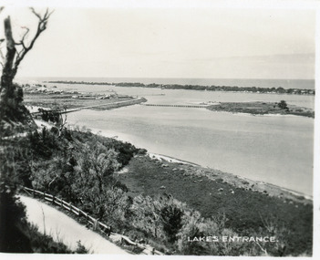
 Lakes Entrance Historical Society
Postcard - Lakes Entrance, Bulmer, H D, 1940c
One Black and White Photograph 6.5 x 11|Two Postcard 8.5 x 14|Two Small format postcard 6 x 9|This is the before paired photograph used in the 150 year, Lakes Entrance 1858-2008 display.|The after paired photograph number is 01156.1 Also one 12 x 16 framed photograph used in room display.Black and white photographic of bridge over North Arm showing the western end of township, sand hummock viewed in distance, Lakes Entrance Victoriatownship, bridges, room display -
 Lakes Entrance Historical Society
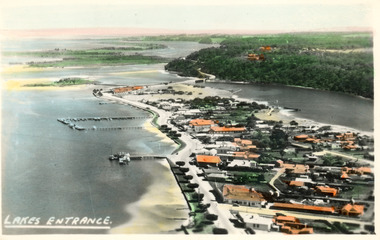
Photograph - Lakes Entrance, 1945c
Two tinted copies, one 8.5 x 13.5 and one 6.5 x 9Black and white postcard showing town, twelve memorial cypress trees and spotting tower on foreshore, post office wharf, boat harbour, Club Hotel at west end of esplanade with five palm trees opposite, causeway to Bullock Island, highway bridge over North Arm, highway up to Jemmys Point, Rigby, Fraser and Flannagan Island's towards Metung. Lakes Entrance VictoriaLakes Entrance islands, aerial photograph, waterways, township -
 Lakes Entrance Historical Society
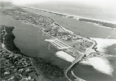
Photograph - Lakes Entrance, 1985c
Photo was cut from Tourist brochureColour photograph showing aerial view of township and the Ninety Mile Beach. Pecks factory on Bullock Island, Old North Arm bridge, bitumen for carpark for future. Fishermen's Club near North Arm Bridge. Photo shows East end of Rigby Island and Snake Island. Glimpse of Red Bluff, Lake Bunga and Lake Tyers in far east. Lakes Entrance Victoriabridges, coast, waterways, topography, township -
 Lakes Entrance Historical Society
Photograph - Lakes Entrance, 1975c
Black and white photograph of an aerial view of township and Kalimna Heights, showing the North Arm bridge and boat ramp, sand buildup in the lake system, boat harbour, sand hummocks and beach as far as Red Bluff. Lakes Entrance Victoriaaerial photograph, topography, township -
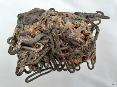 Flagstaff Hill Maritime Museum and Village
Functional object - "S" Hook Buckle, Ca. 1855
The "S" hook buckles were grouped together under the sea as part of the cargo of the vessel Schomberg. "S" hook buckles are used for fastening two ends of fabric together such as harness belts, trouser belts and similar items. The buckles were recovered in October 1980 by the Flagstaff Hill Sub-Aqua Group, Peter Ronald, Barry Lowther and Jeff Bell. ABOUT THE SCHOMBERG (October 6 to December 27, 1855)- When the ship Schomberg was launched in 1855, she was considered the most perfect clipper ship ever to be built. James Baine’s Black Ball Line had commissioned her for their fleet of passenger liners. The Aberdeen builders designed her to sail faster than the clippers designed the three-masted wooden clipper ship to be fast. The timber used for the diagonal planking was British oak with layers of Scottish larch. This luxury emigrant vessel was designed for superior comfort. She had ventilation ducts to provide air to the lower decks and a dining saloon, smoking room, library and bathrooms for the first-class passengers. The master for Schomberg’s maiden voyage was Captain ‘Bully’ Forbes. He drunkenly predicted at her launch that he would make the journey between Liverpool and Melbourne in 60 days. Schomberg departed Liverpool on 6 October 1855 with 430 passengers and 3000 tons of cargo including iron rails and equipment intended the build the Geelong Railway and a bridge over the Yarra from Melbourne to Hawthorn. The poor winds slowed Schomberg’s sail across the equator. She was 78 days out of Liverpool when she ran aground on a sand spit near Peterborough, Victoria, on 27 December; the sand spit and currents were not marked on Forbes’s map. The ship’s Chief Officer spotted the coastal steamer SS Queen at dawn and sent a signal. The master of the SS Queen approached the stranded vessel and all of Schomberg’s passengers safely disembarked. In 1975, 120 years after the Schomberg was wrecked, divers from Flagstaff Hill found an ornate communion set at the wreck site along with many other artefacts. In 1978 a diamond ring was discovered under the concretion in the lid of the communion set, which is currently on display. Former Director of Flagstaff Hill, Peter Ronald, had salvaged most of the artefacts from the wreck. This group of "S" hook buckles and conglomeration of buckles is significant as an example of an item in common use in the mid-19th century and the items carried on ship as cargo. The Schomberg collection as a whole is of historical and archaeological significance at a State level. Flagstaff Hill’s collection of artefacts from the Schomberg is also significant for its association with the Victorian Heritage Registered shipwreck (VHR S 612). The collection is of prime significance because of the relationship between the objects salvaged, as together they help us to interpret the story of the Schomberg. The collection as a whole is historically significant for representing aspects of Victoria's maritime history and its potential to interpret social and historical themes. "S" hook buckles; oval silver alloy buckles contained within a conglomeration of materials from the sea. The group was recovered from the wreck of the Schomberg.flagstaff hill, warrnambool, flagstaff hill maritime museum, maritime museum, shipwreck coast, flagstaff hill maritime village, great ocean road, shipwreck artefact, schomberg, horse harness fitting, harness hardware, "s" hook buckle, "s" hook buckles, conglomeration of buckles, belt buckle, fastener, quick release fastener, flagstaff hill sub-aqua group, peter ronald, barry lowther, jeff bell -
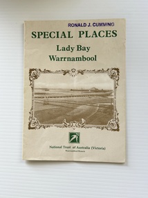 Warrnambool and District Historical Society Inc.
Pamphlet - Special Places Lady Bay Warrnambool, Philprint Warrnambool, 1989
This pamphlet was produced for the Warrnambool Branch of the National Trust of Australia (Victoria) for Heritage Week, April 16-23, 1989 and contains information written by Warrnambool residents about their locality. This was a co-operative venture by people with a common interest in protecting the natural environment near their home. Areas covered in the written information include: Formation of the Coast, Archaeological survey, Gunditjmara History, vegetation, history and recreational uses of the Lady Bay area. The map shows special places of interest including past and present navigational aids, sites of shipwrecks and other historical places of interest. The Warrnambool Branch of the National Trust was originally formed in March 1969 and merged with the Port Fairy Branch in late 1970. In October 1979, the Warrnambool Branch was reformed and operated into the late 1990's. This is an example of a publication produced by the Warrnambool Branch of the National Trust Australia (Victoria). It provides historical information and perspectives of the recreational uses in and around Lady Bay Warrnambool.An A2 piece of buff coloured thick paper folded into eight to make an A5 pamphlet. The front cover has green printing with the National Trust symbol of three eucalyptus leaves in green. There is a brown sepia photograph showing a view across Lady Bay with the suspension bridge across the Merri River in the foreground, Viaduct Road in the middle ground and the breakwater in the background. There is a purple inked stamp on the top right hand corner. The rear cover has brown writing and includes logos of bodies who assisted with the publication. There is a brown line drawing of the viaduct and pier at the Warrnambool Breakwater. The inside of the unfolded pamphlet contains a map of Lady Bay and adjacent area showing places of interest and shipwrecks marked in red circlesFront cover: Special Places Lady Bay Warrnambool National Trust of Australia (Victoria) Warrnambool Branch Ronald J. Cummingwarrnambool, lady bay warrnambool, national trust australia victoria warrnambool branch, heritage week 1989, lady bay shipwrecks -
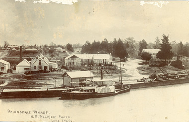 Lakes Entrance Historical Society
Postcard - P.S. Tanjil, Bulmer H D, 1910 c
Postcard was addressed to Mr. H Lindamen, C/o JCD, Bairnsdale. Postcard bears a One Penny red Queen Victoria stamp, franked with number 17. Message on card scribbled out, another stamp has been removed. Also enlargement 16 x 25 cmBlack and white postcard showing P S Tanjil at Bairnsdale Wharf, Victoria. Shed and timber and hand crane on wharf. Industrial buildings, eg, butter factory, foundry behind wharf, post and rail fences, gravel roads and tannery on right, pine trees and end of bridge on far right. Bairnsdale township in background.Bairnsdale Wharf. H.D Bulmer Photo Lake Tyersships and shipping, waterways, wharfs