Showing 171655 items
matching will street
-
 Federation University Historical Collection
Book, J.A. Hoskin & Son, Ballarat Teachers' College Extra Muros, 1958, 1958
February 1958 Classes commence at the new Gillies Street location of Ballarat Teachers’. (BTC Handbook 1965; Beggs-Sunter: 84) Contents include: Editorial, Our Principal Speaks, the President S.R.C., 1958 Highlights, Teaching Round, Section Notes, Social Notes, Hostel Life, Sporting World, Insignias and Awards 1958, Club NotesLight blue cover with dark blue and yellow titles. Soft covered magazine of the Ballarat Teachers College. 48 pages. Articles include Victoria Street Hostel, Gilies Street Hostel, Grampians Trip, Beaufort House , Sturt St House , Camp St Hostel, Club Notes btc, ballarat teachers college, n. harvey, t. w. h. turner, monica miller, m. hines, b. rickard, d. eldridge, n. turnbull, b. english, k. o'neil, p. burgess, m. almeida, e. doney, j. rae, p. wise, w. crocker, p. r. burgess, barry withers, j. bourke, a. linton, s. mckaskill, h. pattenden, d. chandler, a. stafford, r. croft, a. cuthbertson, r. reed, a. sonsee, j. lacy, f. ryan, c. rodger, m. egan, j. hill, t. turner, c. m. canty, j. blair, e. walpole, m. miller, michael long, m. blair, j. blackman, n. beacham, d. astbury, m. bergin, a. constable, g. clarke, g. briggs, m. brown, e. beck, j. badger, g. angwin, g. alexander, k. broad, a. costa, e. davidson, p. burbidge, j. clements, s. elder, d. foster, b. fernandes, b. fischer, m. harcoan, j. heenan, b. hudson, e. jardine, k. hayes, g. coffey, r. dennis, w. cartledge, v. delbridge, n. hawker, l. hales, d. farnsworth, l. hallam, r. fencher, g. karstens, f. leach, r. kelly, m. long, g. macdonald, j. mcdermott, a. lehmann, i. hastie, b. haig, m. jones, l. jeffrey, m. kiefel, j. mcalpine, i. jenkins, j. kenworthy, b. lawton, m. livingston, e. mcormick, d. mckimmie, g. mcintosh, m. mckee, b. murphy, f. mitchell, m. mclachlan, r. power, k. mcdougall, s. murphy, b. nash, d. mckenzie, j. madder, j. meadows, n. mchenry, j. mayo, l. missen, e. muir, g. roberts, k. ryrie, d. ritchie, m. scanlon, e. robinson, m. rutter, j. rogers, m. rae, v. reynolds, j. rees, r. sloley, d. sheen, b. nunn, r. nicholas, b. ruwoldt, m. rowe, l. walker, l. wilkinson, n. wright, d. shoebridge, f. stokie, g. stewart, j. teschendorf, n. souter, e. walker, m. spinks, m. wallace, m. stone, s. tucker, r. taylor, j. short, b. tucker, l. castree, w. craig, r. bibby, b. davies, r. bowker, g. cabble, i. clayton, w. coleman, j. bates, m. elder, l. anthony, j. carmichael, e. edwards, l. anderson, b. cannard, b. drake, j. elliott, p. dunn, b. withers, m. stewart, l. wright, d. smith, r. rowe, k. wilson, k. waltrowicz, j. roach, l. schreenan, i. sutherland, d. williams, b. wynne, j. schaefer, s. shepherd, s. wright, b. whiteside, m. oliver, j. quayle, j. waller, j. taylor, v. rogers, s. moller, m. norman, l. thomas, j. wagner, w. j. craig, e. anthony, r. neville, j. noonan, b. lay, k. hammer, g. moncrieff, r. mason, g. howlett, w. knight, j. matthews, b. lumsden, b. phelan, p. hope, v. la franchi, s. henderson, l. hayne, w. keen, b. forbes, m. gray, g. mcilvena, a. horwill, j. mccumber, m. hateley, k. rieniets, e. fletcher, d. johnson, j. miller, i. ross, c. keys, e. jarvis, m. youngs, j. smith, e. davies, g. commons, p. larmour, r. gowan, b. hedley, miss egan, s. blomfield, m. meyer, k. duffy, h. speedie, j. witton, d. magee, a. pope, p. quinlan, h. jones, miss miller, kevin o'neil, lois e. hayne, w. keem, mr croft, geoff cabble, jack noonan, jan carmichael, gwen macdonald, bev. ross -
 Glenelg Shire Council Cultural Collection
Photograph, 1986
Port of Portland Authority archivesFront: (no inscriptions) Back: Murray Box - Port of Portland Adviser/ Capt Ian Baird - Pilot/ Stan Mode../ Jack Clayton > PPA Board/ at Bentick Street Mural (blue pen, centre)port of portland archives -
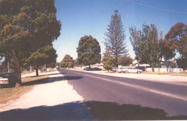 Lakes Entrance Historical Society
Photograph - Roadknight Street View, Lakes Entrance Victoria, 2000 c
Avenue of Queensland brush box trees planted as memorial to John Carpenter pioneer builder of Lakes EntranceColour photograph of Roadknight Street looking east towards Whiter Street and crossroads Mourilyan Street and Stock Street before Norfolk Pine was removed early 2000s Lakes Entrance Victoriaroads and streets, trees, engineering -
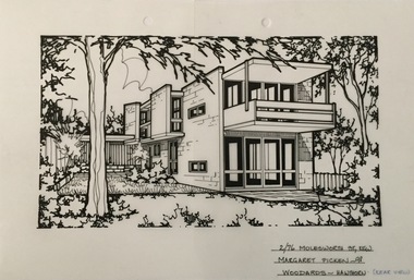 Kew Historical Society Inc
Drawing - Property Illustration, Margaret Picken, 2/76 Molesworth Street, Kew, 1998
After training as a Cartographic Draftsman within the mining industry, I worked as a property illustrator for real estate firms in the eastern suburbs of Melbourne for 22 years from 1983. I initially photographed houses with a Polaroid camera and made a 'thumbnail' sketch while there. The photos were used to scale off a sketch in pencil and then that sketch was overlaid with drafting film and the 'pen and ink' completed. The pens I used were the Rotring ‘Rapidigraph’ drafting pens. The ink was also made by Rotring (German).The film was ‘Rapidraw’, polyester drafting film, double matte. It takes a very fine line and doesn’t bleed. As well as house sketches, there were often floor plans and site plans ordered. Aerial sketches were ordered when the property needed an overall view. (Margaret Picken, 2020)Built in 1968-1970 to a design by Graeme C Gunn, 76 Molesworth Street is one of a series of innovative townhouse developments undertaken by Merchant Builders in the late 1960s, this particular example was the recipient of the Bronze Medal at the Victorian Architecture Awards in 1970. The drawing is one of a series created by Margaret Picken for a number of real estate agents in Melbourne between 1983 and 2006. Each work is signed and dated by the artist.Gift of Margaret Picken, 2020Pen and ink architectural drawing on drafting film of 2/72 Molesworth Street, Kew by Margaret Picken.2/72 MOLESWORTH ST., KEW / MARGARET PICKEN ~98 / WOODARDS ~ HAWTHORN (REAR VIEW)artist -- margaret picken 1950-, architectural drawings -- houses -- kew (vic.), 2/72 molesworth street - kew (vic) -
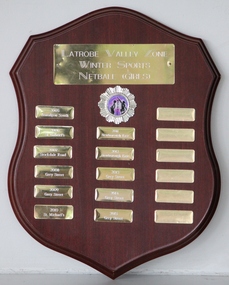 Grey Street Primary School, Traralgon
Shield, Latrobe Valley Zone Winter Sports Netball (Girls)
2005 Traralgon South, 2006 St Gabriel's, 2007 Stockdale Rd, 2008 Grey Street, 2009 Grey Street, 2010 St Michael's, 2011 Newborough East, 2012 Newborough East, 2013 Grey Street, 2014 Grey Street, 2015 Grey Street -
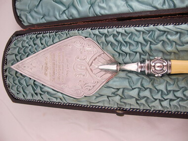 Uniting Church Archives - Synod of Victoria
Ceremonial object - Commemorative Trowel
The foundation stone of the New Wesleyan Church, Were Street, Brighton, Victoria was laid by Mrs W P Wells, the wife of the Superintendent of the Brighton Circuit and President of the Victorian Wesleyan Conference in 1887. The foundation stone was temporarily removed in the late 1930s and the 1937 publication "Were Street Jubilee" details the "proposed Jubilee Church". The same trowel was used when the stone was re-laid in 1955 at the beginning of the construction on the new church. S060.1 Silver commemorative trowel with a bone handle. The front and back both have inscriptions. The front has heavily engraved decoration. S060.2: Presentation box for S060.1. Teal colour rouched satin lined box made of brown leather.S060.1 Front: "TO MRS W. P. Wells ON THE OCCASION OF HER LAYING THE FOUNDATION STONE OF THE Wesleyan Church WERE STREET BRIGHTON APRIL 2ND 1887" S090.1 Back: "THIS TROWEL WAS USED BY REV. A.W.PEDERICK, L.TH. PRESIDENT OF THE CONFERENCE TO Lay the Foundation Stone of the new WERE STREET METHODIST CHURCH 30th JULY 1955".rev a w pederick, mrs w p wells, rev william p wells, were street methodist church brighton victoria, wesleyan church were street brighton victoria -
 Melbourne Legacy
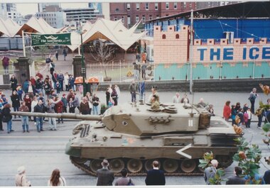
Photograph - Photo, Tanks on Swanston Street
Photos of two tanks driving along Swanston Street taken from the windows of Legacy House. The occasion is not known. The tanks appear to be Leopard 1. One has elaborate equipment on the front. The date is approximately the late 1990s as the Queen Victoria Hospital has been demolished and the QV building has not been started. On the site opposite Legacy House is an open air market called The Sailyards, and what appears to be an ice rink or mini golf, called The Icehouse. Also on the site was the YMCA run skate park called Sail Yards, it was closed in 2001.A record that military equipment was of interest to the Legatees.Colour photos x 4 of two tanks driving North up Swanston Streettanks, streetscape -
 Sunbury Family History and Heritage Society Inc.
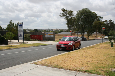
Photograph, Rosa McCall, Anderson Road, February 2014
The street in the photograph is Anderson Road in Sunbury, looking towards Darbyshire Road and the NW. The driveway with the hoarding on the LHS leads to the former Sunbury Storage Business. The photograph was taken in February 2014.A non-digital coloured photograph of a street with four cars parked along it and an advertising notice on the LHS of the image. Some housing and open areas are visible in the distance.anderson road, darbyshire road, sunbury -
 St Kilda Historical Society
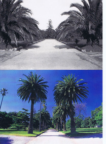
Photograph, St Kilda Botanical Gardens, c. 1950 and c. 1995
Palm avenue at Blessington Street entrance, c. 1950 and 1995colour and black and white postcard (3 post cards - identical)Palm Avenue at Blessington Street entrance. Historic gardens in the City of Port Phillip postcard series celebrating the launch of the Royal Botanic Gardens Melbourne. Flora for Victoria 1996. -
 Kew Historical Society Inc
Photograph - Street Works, Studley Park Road, March 1934
Studley Park Road, like most streets in Kew, was originally a dirt road. Street works during the Great Depression included bituminising major roads in the district. This photograph of Council works originated in the City of Kew Engineers Department as a record of works undertaken. It was given to the collection by a Mrs Fisher in 1998.Well provenanced photograph of Council-funded public works in Kew during the Great Depression. Original sepia monochrome positive of Council workers standing on and beside a dray in Studley Park Road, Kew while resurfacing of the street was taking place. The Kew Junction is just visible behind the men.Typed reverse: "B4 / Kew C.C. / Spreading premixed material on Studley Park Road with drag spreader, view from rear of machine, March 1934"roadworks -- kew (vic.), street works -- kew (vic.), public works kew (vic.), studley park road -- kew (vic.), city of kew -- engineers department, city of kew -- public works -- great depression -- 1930s -
 Northern District School of Nursing. Managed by Bendigo Historical Society Inc.
Photograph - NDSN Lister House buildings
The Northern District School of Nursing opened in 1950 in to address the issues around nurse recruitment, training and education that had previously been hospital based. The residential school was to provide theoretical and in-house education and practical training over three years. The students would also receive practical hands-on training in the wards of associated hospitals. The Northern District School of Nursing operated from Lister House, Rowan Street, Bendigo. It was the first independent school of nursing in Victoria and continued until it closed in 1989.B&W photograph of NDSN Lister House buildings on Rohan Street, 1960s. Three photographs.Circa 1960s in blue birondsn, nursing, lister house buildings -
 Northern District School of Nursing. Managed by Bendigo Historical Society Inc.
Photograph - NDSN Lister House buildings
The Northern District School of Nursing opened in 1950 in to address the issues around nurse recruitment, training and education that had previously been hospital based. The residential school was to provide theoretical and in-house education and practical training over three years. The students would also receive practical hands-on training in the wards of associated hospitals. The Northern District School of Nursing operated from Lister House, Rowan Street, Bendigo. It was the first independent school of nursing in Victoria and continued until it closed in 1989.B&W photograph of north side of NDSN Lister House buildings on Rohan Street, 1960s.ndsn, nursing, lister house buildings -
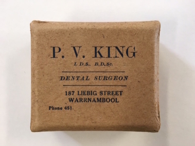 Warrnambool and District Historical Society Inc.
Box, Dentist, 1940s
Pat King was a surgeon dentist in Warrnambool from the late 1920s through to the 1940s. In 1929 the King family owned the stone building in Liebig Street next to the old Tattersalls Hotel (now McDonalds fast food outlet). The King family remodelled the building and turned it into shops with living quarters upstairs. Pat King had his dental business in the centre of the building and his brother had a produce store at the northern end of the building. It was known at that time as Kings building. By the early fifties, at the time of his death, Pat King had been living at 32 Howard Street. Kings building was auctioned in 1953.This little box is of some interest as it came from the dental business of Pat King, a prominent dentist in Warrnambool in the 1930s and 40s. This is a small buff-coloured cardboard box with a lid. The four corners of the box and the lid have metal rivet reinforcements and a semi-circular cardboard inset has been stapled into the box. The box was used by the dentist Pat King of Warrnambool and the box appears to have been made to hold dentures. Lid of box: ‘P. V. King, L.D.S, B.D.Sc., Dental Surgeon, 187 Liebig Street, Warrnambool, Phone 451’. kings building,, warrnambool, pat king, dentist, history -
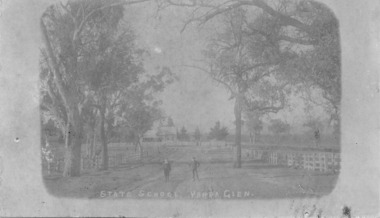 Yarra Glen & District Historical Society
Sepia postcards, State School Yarra Glen 19th century
Faded sepia photograph of the Yarra Glen State School taken from the School Lane (now called Yarraview Road). In the foreground are two schoolboys and three large trees. Post-and-rail fences are on either side of the road. In the distance is the school building on Symond Street.On the back at the top "POST CARD". Below that is "FOR CORRESPONDENCE" to the left and "FOR ADDRESS ONLY" to the right. Centre right is a stamp "YARRA GLEN/Mrs. E. Smith/SYMONDS STREET/YARRA GLEN 3775"yarra glen, post and rail fence, yarra flats, yarra glen state school, yarra glen primary school, symond street, school lane, yarraview road, schoolboys, school boys -
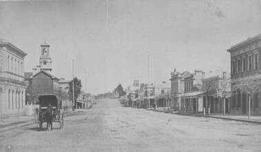
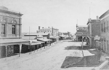 Stawell Historical Society Inc
Photograph, Upper Main Street Stawell looking West with the Mechanics institute built in 1875 1878
Upper Main Street looking West from Mechanics Institute built in 1875. Mechanics Institute, Joseph Dawe Stawell Meat Market, D.B. O'Callaghan, Boot & Shoe Warehouse, Stawell Potato Depot, Ben S. Dawson Chemist, R.H. Wadsworth Jewler Watchmaker, English Scottish & Australian Bank, Bone Saddler, Hunter Bull & Mouth Hotel. On North side of street is J. Allingham Draper, Chadwick & Co Draper, D. Telford Farm Produce, Bank of Victoria. Photo taken 1878The "Top End" of Main Street. looking west. The Mechanics Insitute on the Left dates the photo about 1880. Some of the larger buildings have been restored.Victorian Views. C. Herbert, Photo. Stawell 1878stawell business streetscape -
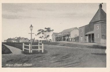 Phillip Island and District Historical Society Inc.
Photographs, Rose Stereograph Co. et al, Early Cowes, Phillip Island, 20th Centure
A collection of three photographs donated by Thelma Fithall.Three Black & White photograph/postcards of Cowes, Phillip Island. 282-01. The Main Street, Thompson Avenue, Cowes, Phillip Island. 282-02. Looking down to the Cowes Pier with a large crowd of people and several old vehicles. 282-03. The Esplanade, Cowes showing the Isle of Wight Hotel, several vehicles and people.282-01. Main Street, Cowes. 282-02. Valentine Series No. 2262. The Pier, Cowes. 282-03. Valentine Series No. 3396. The Esplanade, Cowes.cowes foreshore - cowes pier - phillip island, the esplanade cowes, isle of wight hotel - cowes phillip island, main street cowes, phillip island -
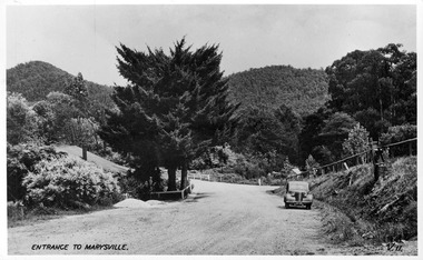 Marysville & District Historical Society
Postcard (item) - Black and white postcard, Valentine Publishing Co. Pty. Ltd, Entrance to Marysville V.11, 1923-1963
A digital copy of an early black and white photograph of the Marysville-Wood's Point Road at the corner with Murchison Street in Marysville in Victoria.A digital copy of an early black and white photograph of the Marysville-Wood's Point Road at the corner with Murchison Street in Marysville in Victoria. This postcard was published by the Valentine Publishing Co. Pty. Ltd. as a souvenir of Marysville.marysville, victoria, postcard, valentine publishing co, souvenir, murchison street, marysville-wood's point road -
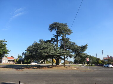 Federation University Historical Collection
Photograph, Atlantic Cedar in South Street, Ballarat, 13/04/2020
Colour photograph of an Atlantic Cedar (Cedrus atlantica glauca) on the intersection of South Street, Skipton Street and Lyons Street South, Ballarat.ballarat, skipton street, lyons street north, tree, atlantic cedar, south street -
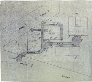 Federation University Historical Collection
Plan, Plan for a Service Plan at the Ballarat School of Mines
This plan appears to show buildings that were not built. Plkan showing the section of the Federation University SMB Campus between Grant Street and Lydiard Street, near Armstrong Street South.smb campus, ballarat school of mines, grant street, lydiard street, former ballarat supreme court -
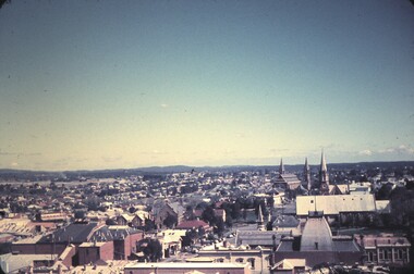 Bendigo Historical Society Inc.
Slide - BENDIGO & EASTER FAIR, 1963
View from Rosalind Park tower looking south across View street and Forest Street, church in Forest Street in slide.slide, bendigo, city view -
Port Melbourne Historical & Preservation Society
Photograph - Outline of demolished house (139 Station Street), 137 Station Street, Port Melbourne, Peter Libbis, 6 May 1998
Taken by Peter Libbis between demolition and rebuilding of 139One of four photos of 137 Station Street, showing outline of wall of demolished 139 Station Street (corner of Spring Street)demolitions -
Port Melbourne Historical & Preservation Society
Document - Specification, Metalling and chanelling, Clark Street from Graham Street to Poolman Street, Engineering Department, Town of Port Melbourne, 14 Mar 1893
Specification for metalling channelling Clark Street from Graham Street to Poolman Street Loan Works 1893; relates to plan 96.2Signed by JJ Bartlett (Mayor)engineering - roads streets lanes and footpaths, arthur victor heath, town clerks, james john bartlett, mayors -
Port Melbourne Historical & Preservation Society
Plan - Metalling and channelling Clark Street from Graham Street to Poolman Street, Engineering Department, Town of Port Melbourne, 14 Mar 1893
Plan for metalling channelling Clark Street from Graham Street to Poolman Street Loan Works 1893; relates to specification 96.1Signed by JJ Bartlett (Mayor)engineering - roads streets lanes and footpaths, arthur victor heath, town clerks, james john bartlett, mayors -
Port Melbourne Historical & Preservation Society
Document - Specification, Pool Street from Nott Street to Princes Street, Engineering Department, Town of Port Melbourne, 14 Mar 1893
Plan for Pool Street from Nott Street to Princes Street Loan Works 1893 plan 18; relates to plan 97.2Signed by JJ Bartlett (Mayor) 14.3.1893engineering - roads streets lanes and footpaths, town planning, town clerks, mayors, arthur victor heath, james john bartlett -
Port Melbourne Historical & Preservation Society
Plan - Pool Street from Nott Street to Princes Street, Engineering Department, Town of Port Melbourne, 14 Mar 1893
Plan for Pool Street from Nott Street to Princes Street Loan Works 1893 plan 18; relates to specification 97.1Signed by JJ Bartlett (Mayor) 14.3.1893engineering - roads streets lanes and footpaths, town planning, town clerks, mayors, arthur victor heath, james john bartlett -
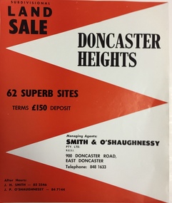 Kew Historical Society Inc
Plan - Subdivision Plan, Doncaster Heights
Real estate brochure produced for Smith & O'Shaughnessy of 900 Doncaster Road for the sale of the '65 superb sites' in the Doncaster Heights Estate. Streets with lots for sale include: Church Road, Norfolk Circuit, and Hampshire Road.Historic subdivision planFour-page colour real estate brochure issued for the sale of the Doncaster Heights Estate. The inside pages include a street plan with the numbered lots.subdivision plans - doncaster, doncaster heights estate -
 The Beechworth Burke Museum
Photograph, 1875
This photograph was taken in the winter of 1875 from the Telegraph Station looking up Ford Street towards the Church of England. Picture is a horse and wagon walking towards the camera. Black and white rectangular postcard. The image is printed on matt photographic paper and mounted on cardboard. This photograph depicts Ford Street looking south C 1875 in Beechworth.Obverse: NO INSCRIPTION Reverse: 5570 35 Beechworth about 1875 American & Australian Photographic Company. Victoria Branch. C. BAYLISS, Manager No. 61 Extra Copies may be had by sending Number to present Address. beechworth, ford street, 1875, horse, wagon, horse and wagon, church of england, burke museum, winter