Showing 10466 items
matching plan
-
 Whitehorse Historical Society Inc.
Document, Boyd Street, Blackburn South
Sale brochure for property 14 Boyd Street, Blackburn South.Sale brochure for property 14 Boyd Street, Blackburn South. Agent Woodards. Pictures and floor plans.Sale brochure for property 14 Boyd Street, Blackburn South. boyd street, blackburn south no 14 -
 Bendigo Historical Society Inc.
Document - HOWARD AND VIOLET JOLLEY COLLECTION: PLANS
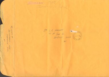
3 pages of plans, drawn in black pen, for replica of John Robinson Duigan's Aircraft, 1919. Plans appear to be copies. A3 Manilla envelope addressed to Dr. L.K. Morgan, 57 McIvor Road, Bendigo contains plans. On rear of envelope: RL Lewis Brightwells Hill, Heathcote, 3523. Front view, side view and plan view written respectively on each plan. On bottom RH of 'Front view' plan is stamp from Civil Aviation Authority Australia , dated 9.12.91. On top RH corner is written ' these drawings are not be be reproduced by anyone other than the builder, Ronald Lloyd Lewis' Items in this collection were donated by Dr. Jan Sherringham, whose husband is a pilot. It can only be assumed that this document belonged to them as it postdates Violet's death.person, bendigo, john robinson duigan, duigan, john robinson, lewis, ronald lloyd, aeroplane, plan -
 RMIT Design Archives
Work on paper - Architectural drawings, Aboriginal Keeping Place, Shepparton International Village
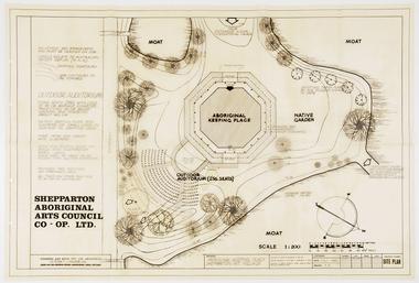
Site plan drawing of the Shepparton Aboriginal Arts Council building, now known as the Bangerang Cultural Centre. The building is located in the Parkside Gardens, formerly the Shepparton International Village, and is the first Aboriginal cultural museum developed and managed by the Aboriginal community. The building is part of the Victorian Heritage Register. Romberg designed the building in conjunction with project instigator and Bangerang Elder, John Sandy Atkinson, OAM. At the request of Romberg, Atkinson created some concept sketches for the building from which Romberg designed the finished structure.Site PlanInitialed in grey pencil, bottom right: 'F.R'architecture, museum -
 Whitehorse Historical Society Inc.
Article - Newspaper Clipppings, Worker's paradise factory at Blackburn, 1951 & 1988
'The Belgians in Australia' gives a brief history of Roger, 1950 - 1975.Belgian, Roger de Stoop, plans a spinning and weaving factory at Blackburn. He plans many innovative amenities to keep his staff happy. Also another article - 'The Belgians in Australia' gives a brief history of Roger, 1950 - 1975. 'The Belgians in Australia' gives a brief history of Roger, 1950 - 1975.textiles, de stoop textile factory, de stoop, roger -
 Melbourne Tram Museum
Ephemera - Real estate sale, Prahran Hodges, "Rosemont Hill Estate", Oct. 1917
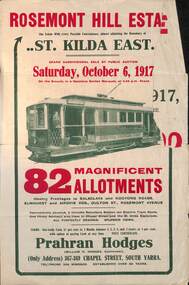
Pamphlet advertising the sale of land at the "Rosemont Hill Estate", Balaclava Road, St Kilda East, 6-10-1917. On the front cover has a photo of PMTT tram No. 27. Gives terms of sale, the plan of the subdivision, and a general locality plan showing tram and rail lines. Land prices have been written in for some blocks on the pamphlet. Demonstrates the style of land sale pamphlet including the availability of tram services to prospective purchasers.Pamphlet - folded - printed in two colours of cream coloured paper with photographs and plans.has pencil notes re sale price and notes for some blocks.sale of land, trams, real estate, balaclava road, st kilda east, pmtt, tram 27, rosemont hill estate -
 Greensborough Historical Society
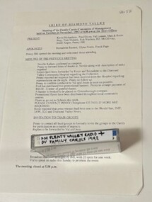
Mixed media - Audio Cassette and Minutes, Diamond Valley Choral Society, Shire of Diamond Valley Festival of Carols, performed by Diamond Valley Choral Society 1992, 06/12/1992
A recording of Shire of Diamond Valley Festival of Carols, December 1992. This performance is by the Diamond Valley Choral Society. Includes minutes of planning meetings.1 audio cassette in clear plastic case and minutes of planning meetings.Handwritten on cassette: "FM Plenty Valley Radio + DV Family carols 1992".christmas music, carols, shire of diamond valley, diamond valley choral society -
 Federation University Historical Collection
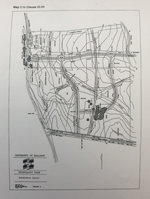
Plan, Ballarat Technology Park plans, c1998
.1) Alotment plan .2) contour planballarat technology park, mount helen campus, canadian wetlands, ballarat to buninyong railway line, sub-division layout -
 Kew Historical Society Inc
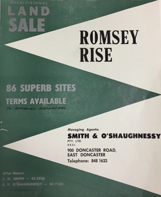
Plan - Subdivision Plan, Romsey Rise, Doncaster East
Real estate brochure for a land sale of 86 sites in East Doncaster. Roads identified in the plan include: George Street, Dennert Street, Worthing Avenue, Sandhurst Street, Belinda Crescent, and Romsey Rise.Historic subdivision plan of a Doncaster East EstateFour page colour real estate brochure including on page 2 a subdivision plan for the Romsey Rise estate in East Doncaster. This record also includes a separate price list for the lots.real estate plans, subdivision plans - doncaster east, romsey rise estate - doncaster east (vic) -
Port Melbourne Historical & Preservation Society
Plan - Immigration sculpture, Beacon Cove, Orchard Design Studio, Mark Weichart, 1998
Mirvac, Beacon Cove developers, commissioned this sculpture. Orchard Design Studio contacted PMH&PS for 19th Century migrant ship names, to be handcarved into jarrah portion of sculpture, and for approval of 20th century ship names for the steel section. In return we requested a copy of these plans.Presentation plans (two sheets) for sculpture at Beacon Cove, designed by Orchard Design Studio of Pakenham. One in full colour, one a photocopy only. Subject: immigration.Photocopy signed by the artist, Mark Weichart.piers and wharves - station pier, immigration, transport - shipping, arts and entertainment - visual arts, mark weichart, mirvac, sculpture, orchard design studio -
Bendigo Historical Society Inc.
Plan - MARKS COLLECTION: PLAN OF FORTUNA VILLA
Copy of overall plan for Fortuna Villa. Plan shows entrance and garden elevations; ground plan and principal floor plan. Written on top of plan 'G Lansell Esq' 'Scale 8 feet to 1 inch'.bendigo, house, fortuna villa -
Clunes Museum
Newspaper - ARTICLE, Hepburn Advocate, SUPPORT SEWERAGE PLANS AND CLUNES WILL DEVELOP, 16/4/1997
PROPOSED SEWERAGE PLAN FOR CLUNESARTICLE IN THE ADVOCATE 16 APRIL, 1997, P.3. 'SUPPORT SEWERAGE PLANS AND CLUNES WILL DEVELOP' MAYOR TELLS RESIDENTSsewerage, hepburn shire, 1997 -
University of Melbourne, Burnley Campus Archives
Plan - Photocopy, Wendy Varcoe, Killamont, 1907? 1980?
Larger plan is probably of original fencing and drains from C.B. Luffman's layout. Killamont is the only known surviving private garden designed by Luffman.(1907).Photocopies of 2 hand drawn maps/plans of the garden at "Killamont." Drawn by Wendy Varcoe. Garden designed by C. B. Luffmann. (Also see B10.0040 Conservation Analysis and other C.B. Luffmann files in Box 75 A .)gardens, killamont, wendy varcoe, charles bogue luffman -
Stawell Historical Society Inc
Archive, Plans from the Dept. Works Ararat
Archive 4262 Plans For Pleasent Creek 4262 - Existing Plans for Pleasent Creek 4262A - 2A Bellfield Unit 4262B - 2B Fyans Unit 4262C - 2C Nurses Unit 4262D - Biala Unit 4262E - Hostel Unit 4262F - Residence 3 & 4 (X2) 4262G - Residence 5 & 6 4262H - Nara Unit 4262I - Syme Unit 4262J - Lonsdale Unit 4262K - School Buildings 4262L - Recreation Building 4262M - Administration Building 4262N - Alexandra Building 42620 - L.T.O. building 4262P - Engineers Workshop & Laundry 4262Q - Sewing Room & Stores 4262R - Carpenters, Painters & Gardener's Workshops 4262S - 3 Existing Plans for Pleasent Creek Centre Stawell & Emergency Water Legend 4262T - 7 Existing Plans for Plesent Creek Stawell Centre Stawell Inc: Grid Squares 4262-1 73.5 X 56 CM Sheet No.1 New Dining Room Special School Amended Setout of Windows 4262-1A - 73.5 X 56 CM Sheet No. 2 Special School Stawell Joiners details 4262-1B - 73.5 X 56 CM Sheet No. 3 Pleasant Creek School: New Dining Room 4262-1C -73.5 X 56 CM Sheet No. 4 Pleasant Creek School Joinery details 4262-1D - 73.5 X 56 CM Sheet No. 5 Pleasant Creek School Joinery Details 4262-1E - 48 X 39 CM Section AA Pleasant Creek School Dining Room Stainless Steel Sinks & Drains 4262 -1F 50 X 69X5 CM School for Subnormal Children - Stawell Mental Hospital Elvation and Accordion 4262-1G 56 X 40 CM Sheet 6 Stawell Pleasant Creek School - Joinery Detail 4262-1H 75 X 54 CM Stawell Pleasant Creek School - Detail of Serving Window 4262 -1I 75 X 54 CM Stawell Hospital for the Insane - Cills to Windows, Store and soon to be Male Division 4262 -1J 50.5 X 24 CM Stawell Pleasant Creek School - deatils of Serving Window 4262 -2 39 X 34 CM Concongella School 1136 Sundry Works etc. 4262-2A 20 X 35 CM State School 1702 Joel Joel - Remodeling & Repairs Painting etc. 4262-2B 36 X 44.5 CM Mokepilly School Remodelling 4262-2C 21 X 34 CM 2951 Marnoo East - Sketch of Proposed Cloak Room 4262-2D 21 X 34 CM SS 2951 Marnoo East Elevation Showing New Cloak Room 4262-2E 40 X 39 CM Additions & Alterations to Concongella School 1136 4262-2F 21.3 X 33.5 CM School 2951 Marnoo East Elvation and Ground Plan 4262-2G 38 X 33.5 CM School 1554 Marnoo & Residence 4262-2H 21.5 33.5 CM Marnoo SS No 1554 Repairs and Painting 4262-2I 205 X 32 CM Marnoo School 1554 Alternative Drawingsfor building In Brick 4262-2J 50 X 43.5 CM New Concrete School 1554 Marnoo 4262-2K 62 X 56 CM Removal & Alterations to Marnoo's School No. 1554 4262-2L 49.5 X 33.5 CM Great Western School 860 - Teacher's Residence 4262-2M 20.5 X 33.5 CM Great western School 860 - Elevation & Ground Plan 4262-2N 20.5 X 33.5 CM Great Western School 860 - Shelter Sheds & Tank Stand 4262-2O 25.5 X 30 CM Great Western School 860 - Floor Plan 4262-2P 20 X 34 CM Residence to Great Western Schhool - Plastering & Painting etc,. 4262-2Q 59 X 50.5 CM Great Western School860 - Additions 4262-2R 21 X 33 CM Plan school 263 Glenorchy 4262-2S 21 X 33 CM Plan School 263 Glenorchy 4262-2T 35 X 38 CM Glenorchy School 263 Remodelling etc,. to Teacher's Residence 4262-2U 33.5 X 22 CM Repairs & Repainting School & Residence Glenorchy SS 263 4262-2V 53 X 34 CM Proposed Sleepout for Teachers Residence Glenorchy School 4262-2W 53.5 38 CM Glenorchy School No. 263 and Residence Raising School buildings etc,. 4262-2X 29 x 56 CM Glenorchy School 263 New Cloak Room etc. 4262-3 22 X 31 CM Drawing of Part of Builing 4262-3A 35 X 46 CM Stawell Roof Plan & Side Elevation 4262-3B 48 X 65 CM State School Drawing No 1 4262-3C 32 X 27 CM Renewal of Existing water Supply 4262-3E 61 X 40 CM Stawell Infant State School 503 - External Repairs & Renovations 4262-3F 48.5 X 53 CM Education Department Stawell State School Drawig No 2 Contract 181 4262-3G 73 X 55 CM Alterations & Additions S.S. 502 Stawell Drawing No.1 4262-3H 73 X 55 CM Alterations & Additions S.S. 502 Stawell Drawing No.2 4242-3I 73 X 55 CM Alterations & Additions S.S. 502 Stawell Drawing No.3 4262-3J 56 X 34 CM State School 502 Plan Clarifying & Chlorinating Chamber 4262-3K 33 X 21 CM Part Ground Plan StawellSchool 502 - Accordion Doors etc. 4262-3L 60 X 54 CM Accordion Door details for School at Stawell 502 4262-3M 69 X 52 CM Stawell State School No 502 External repairs - Renovations 4262-3N 72 X 55 CM Altereed & Additions State School 502 Drawing No 1 4262-30 35 X 21 CM Stawell School 502 New Wood Shed etc 4262-3P 68 X 34 CM Main School - New Gutters shown thus. State School 502 Stawell Renewals Eaves Guttering 4262-3Q 58 X 34 CM State School No 502. Stawell Block Plan 4262-3R 73 X 55 CM State School 502 Drawing No.2 4262-4 99 X 79 CM State of Victoria Public Works Department - Layout of heating System Administration Block and Toddlers Playroom. Pleasant Creek special School (2 Copies) 42624A 86 X 89.5 CM Existing Layout of Peasnt Creek Centre Fire Service Water Mains 4262-4B 87X 59.5 CM Department of Human Services Victoria Emergancy Schematic Palns Pleasant Creek Centre ( Plans also in 4262 & 4262-1?) Cover Sheet. Former Pleasant Creek Hospital site. Sometimes referred to as Pleasant Creek Special School and sometimes Pleasant Creet Training Centre.Plans of Schools and other Buildings -
 Kew Historical Society Inc
Plan - Subdivision Plan, Mount Ida Estate, 1925
The Kew Historical Society collection includes almost 100 subdivision plans pertaining to suburbs of the City of Melbourne. Most of these are of Kew, Kew East or Studley Park, although a smaller number are plans of Camberwell, Deepdene, Balwyn and Hawthorn. It is believed that the majority of the plans were gifted to the Society by persons connected with the real estate firm - J. R. Mathers and McMillan, 136 Cotham Road, Kew. The Plans in the collection are rarely in pristine form, being working plans on which the agent would write notes and record lots sold and the prices of these. The subdivision plans are historically significant examples of the growth of urban Melbourne from the beginning of the 20th Century up until the 1980s. A number of the plans are double-sided and often include a photograph on the reverse. A number of the latter are by noted photographers such as J.E. Barnes.The Mount Ida Estate was a subdivision of fifty-two residential allotments bordering Tooronga Road, Leura Grove, Constance Street, and Mount Ida Avenue in Hawthorn East. The report of the sale of the Estate in The Argus (21 September) claimed that over 1,000 people attended the auction and that all allotments were sold on the day. On the other side of Constance Street, the plan identifies the ‘Eastern Recreation Reserve’ (now Anderson Park).subdivision plans - hawthorn -
 Kew Historical Society Inc
Plan - Subdivision Plan, Camberwell Mountain View Estate, 1923
The Kew Historical Society collection includes almost 100 subdivision plans pertaining to suburbs of the City of Melbourne. Most of these are of Kew, Kew East or Studley Park, although a smaller number are plans of Camberwell, Deepdene, Balwyn and Hawthorn. It is believed that the majority of the plans were gifted to the Society by persons connected with the real estate firm - J. R. Mathers and McMillan, 136 Cotham Road, Kew. The Plans in the collection are rarely in pristine form, being working plans on which the agent would write notes and record lots sold and the prices of these. The subdivision plans are historically significant examples of the growth of urban Melbourne from the beginning of the 20th Century up until the 1980s. A number of the plans are double-sided and often include a photograph on the reverse. A number of the latter are by noted photographers such as J.E. Barnes.The so-called Camberwell Mountain View Estate was a subdivision on ‘the corner [of] Burke Road, Eyre and Wills Streets, Deepdene’. The Estate was not the first attempt to subdivide this land holding. In 1884, 1888 and 1894 the Belmore Park subdivision proposed 18 allotments for this parcel of land. The final stages of the Belmore Park subdivision occurred during the Depression of the 1890s. Apart from perhaps one block facing Burke Road, which is unnumbered in the Mountain View Estate subdivision, the rest must have remained unsold. The later subdivision would redraw the original 18 allotments, creating 22 new lots. In the Locality Plan on the left side of the subdivision plan, Deepdene Station, which formed part of the Outer Circle Railway is represented, as is the location of Deepdene Primary School. A selling point was the proposed extension of the Burke Road tram beyond its terminus at Cotham Road. The extension did not eventuate.subdivision plans - camberwell, mountain view estate -
 Warrnambool and District Historical Society Inc.
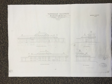
Map, Victorian Railway W'bool No1 & No2, 1897
These two sheets show the 1897 plans drawn up by the Victorian Railways for the erection of the Warrnambool Railway Station building. It is a two-storey building still existing today. The railway came to Warrnambool in 1890 and they must have used temporary buildings for seven years before this railway building was erected. It had offices, booking counter and public facilities on the ground floor and housing for the Station Master on the first floor. The building erected was a typical design for country town railway stations and many of similar design were erected in the 1880s and 90s. These plans are important because they show clearly the design of the Warrnambool Railway Station buildings when they were first erected in the 1890s.They will be very useful for researchers. The coming of the railway was a significant event in Warrnambool’s history and did much to make the port and shipping a less viable proposition.These are two architect’s plans and drawings of the Warrnambool Railway Station building (1897). The drawings are black and white and the first plan shows the ground floor plan and the first floor plan and the outbuildings. The second plan shows drawings of the building with its elevation to the platform and its elevation to Merri Street. There are two stamps of the Railways Department, Melbourne. These are copies, not originals. ‘Victorian Railways, Warrnambool, Station Buildings, Scale 8 feet to one inch, Contract No. 6379B (Nos. 1 and 2)’warrnambool, railway station buildings -
Bendigo Historical Society Inc.
Plan - MARKS COLLECTION: FORTUNA PLANS
Copy of Plan: on top of plan 'Additions to Fortuna Villa for Geo Lansell Esq, scale 8 feet to one inch' Drawings of additions: ground plan, garden plan, second and third floor plan (mainly elevations).buildings, house, fortuna villa -
 Ringwood and District Historical Society
Newspaper, Scrapbook Clipping, Library Collection, Ringwood, Victoria
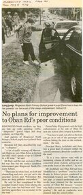
Newspaper Clipping from the ""Mail", 5 May 1998 P20. "No plans for improvement to Oban Rd's poor condition"Ringwood North residents say they are fed up with speeding traffic, "dangerous" gravel edges and deep potholes on Oban Road. Ringwood North Primary School Principal Barry Archibald said there was a great deal of concern within the school community about the condition of the road. A council spokesman said no works were planned for the unsealed section of Oban Road because "council only had a certain amount of money for grading" He said no roadworks were planned near the school either. -
Bendigo Historical Society Inc.
Plan - MARKS COLLECTION: PLAN OF ALTERATIONS AND ADDITIONS TO THE PRIVATE RESIDENCE OF GEO. LANSELL ESQR
Plan for the alteration and additions to Fortuna Villaa, the private residence of George Lansell Plan shows southern, eastern & western elevations, floor and roof plan for the additions to the residence Coloured hand drawn construction plan Plan is undated plan has severe damage on LHS and bottom of the sheet -
 Greensborough Historical Society
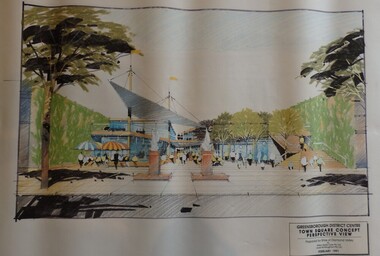
Planning Document, Shire of Diamond Valley, Greensborough District Centre, Town Square Concept Plans 1991, 1991_02
Plans and concept drawings for the proposed development of the Greensborough District Centre, Town Square. Shire of Diamond Valley existed from 1964 to 1994.7 plans and 2 concept drawings, black and coloured ink on white paper.shire of diamond valley, greensborough -
 Orbost & District Historical Society
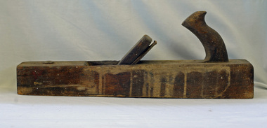
trying plane, first half 20th century
A heavy trying plane would have been used in construction work on rural properties. It can be used for planing hard, difficult timbers.Tools such as this would have been used in the construction of local homes, or rural outbuildings in early Orbost.. It is representative of an era before power tools. A long, heavy wooden plane used in smoothing the edges of roughly planed wood.woodwork tools plane-trying -
Whitehorse Historical Society Inc.
Article, Super medical centre
Article about Blackburn Clinic.Article about Blackburn Clinic which plans a $5 million medical complex in Maple Street, Blackburn.Article about Blackburn Clinic. medical services, blackburn clinic, carson, neil, thwaites, morrison, sallai, tom, blackburn primary school, no. 2923, gelb, joe, maple street, blackburn -
Port Melbourne Historical & Preservation Society
Photograph - Aerial view of West Gate Bridge, Oct 1990
Cut from the 1990 City of Melbourne Strategy PlanPage from 1990 City of Melbourne Strategy Plan with aerial photograph of West Gate Bridge and Fishermen's Bendtown planning, engineering - bridges -
 Whitehorse Historical Society Inc.
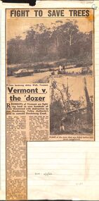
Article, Fight to save trees: Vermont v. the dozer, 1966
Residents of Vermont are fighting to stop the destruction of trees .Residents of Vermont are fighting to stop the destruction of trees owing to the Dandenong Valley Authority's plan to remodel Dandenong CreekResidents of Vermont are fighting to stop the destruction of trees .vermont, dandenong creek, dandenong valley authority, abbey walk, vermont, larkman, barry, terry, w. g., mann, j. n. -
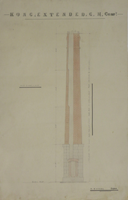 Federation University Historical Collection
Plan, Kong Extended Gold Mining Company Chimney Plans, not dated
Two plans for a brick chimney with hand colouring .1) plan for brick chimney .2) plan for interior of chimneykong extended gold mining company, w. watson, plans for chimney, mining, architectural plans -
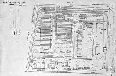 Melbourne Tram Museum
Document - Plan of Preston Workshops, The Met, c1990
Plan shows the layout of the Preston Workshops facility during The Met era, c1990. Shows tracks, buildings and overall land dimensions. Prepared prior to the duplication of the track over the railway line in Miller St. Yields information about Preston Workshops during The Met era.Photocopy - foolscap sheet of a Plan of Preston Workshops - The Met c1990tramways, preston workshops, drawings, plans -
 Beechworth Honey Archive
Hand-Drawn Diagram of Land by Frank Lebbell Frost September 1920
Hand-drawn diagram of land at Dookie by Frank L. Frost. Depicts plan od three allotments.hand drawn, hand-drawn, plan, land, dookie, frost, beekeeper, beechworth honey -
 Kew Historical Society Inc
Plan - Subdivision Plan, Six Big Home Sites, Camberwell North, c.1936
Subdivision plans are historically important documents used as evidence of the growth of suburbs in Australia. They frequently provide information about when the land was sold on which a built structure was subsequently constructed as well as evidence relating to surveyors and real estate and financial agents. The numerous subdivision plans in the Kew Historical Society's collection represent working documents, ranging from the initial sketches made in planning a subdivision to printed plans on which auctioneers or agents listed the prices for which individual lots were sold. In a number of cases, the reverse of a subdivision plan in the collection includes a photograph of a house that was also for sale by the agent. These photographs provide significant heritage information relating house design and decoration, fencing and household gardens.A subdivision in what is currently Balwyn, but which was advertised as being in Camberwell North. The subdivision included six allotments facing Buchanan Avenue and Houghton Street. The subdivision was to the east of the Pointed Firs Estate (1936). In addition to the intrinsic value of this subdivision plan, it also reveals information about the development of transport infrastructure in this area. The subdivision plan notes that the Tramways Board has approved the extension of the tram route past the current terminus at Balwyn Road.subdivision plans - camberwell -
 Surrey Hills Historical Society Collection
Book, Medlow Garden Survey and Landscape capability study 1983, Oct-83
Includes: Plan of Subdivision, Detailed plan, map of garden, Auctioneer's plan for 1854 sale, Botanical plan of Medlow & Landscape history notes. Full title : Medlow Garden survey and landscape capability survey. A report for the National Trust of Australia (Victoria) A report detailing the landscape survey of Medlow Garden estate. Includes landscape history, cultural significance, particulars about vegetarian, garden, rehabilitation and plans.A report detailing the landscape survey of Medlow Garden estate. Includes landscape history, cultural significance, particulars about vegetarian, garden, rehabilitation and plans. 38 p illland surveys, medlow garden, bismark estate, rosalie estate, warrigal road, surrey hills, bismarck avenue, warwick avenue, t p payne, (mr) hugh glass, boroondara, (maj.) (mr) - cairncross, (mrs) mary jane cairncross, (dr)(mr) richard joseph bull, (mrs) catherine grace bull, (miss) norma bull, (mr) ronald richard bull, medlow, house names, (mr) rex swanson, landform australia -
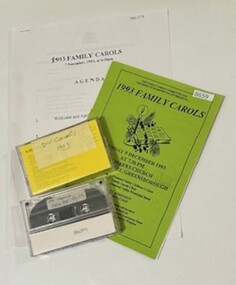 Greensborough Historical Society
Mixed media - Audio Cassette and Minutes, Diamond Valley Choral Society, Shire of Diamond Valley Family Carols, performed by Diamond Valley Choral Society 1993, 07/12/1993
A recording of Shire of Diamond Valley Festival of Carols, 07/12/1993. This performance is by the Diamond Valley Choral Society. Includes program and minutes of planning meetings.2 audio cassettes in clear plastic case, program and minutes of planning meetings.Handwritten on cassette: "DV Carols Dec 93 ex PV Radio".christmas music, carols, shire of diamond valley, diamond valley choral society