Showing 1845 items matching "rivers in victoria"
-
 The Beechworth Burke Museum
Geological specimen - Fossil Leaves
A fossil refers to any remains or traces of past life that are preserved in the rock. It could be remains of plants or animals. Fossil leaves are commonly found on different types of rocks. These fossils can go as far back as the Triassic Age just like the series of fossil plants collected at Denmark Hill, Ipswich in Queensland. Fossils leaves are formed when dead plants get buried by sediments like mud, sand, or volcanic ash. Often, it gets detached cleanly from stems along a special layer of weak cells, then twigs, and, less commonly, cones of conifers and fruits and seeds of flowering plants. Over time, the leaves or pieces of leaves get buried by more sediments and eventually gets 'lithified' or hardened into a rock. Erosions and mining can cause the rocks to break and reveal the fossils buried in it. Fossilisation frequently takes place at sites in the lowlands where deposits of clay, silt, sand are found. This is usually due to weathering and erosion of rocks. Fossil leaves can provide information about ancient Australia's way of living. It contributes to Victorian biodiversity records and its botanical collections. It also contributes information on the geographical profile of Victoria as fossilisation usually occur at estuaries and deltas of rivers, river flood plains, ponds and lakes. This specimen is part of a larger collection of geological and mineral specimens collected from around Australia (and some parts of the world) and donated to the Burke Museum between 1868-1880. A large percentage of these specimens were collected in Victoria as part of the Geological Survey of Victoria that begun in 1852 (in response to the Gold Rush) to study and map the geology of Victoria. Collecting geological specimens was an important part of mapping and understanding the scientific makeup of the earth. Many of these specimens were sent to research and collecting organisations across Australia, including the Burke Museum, to educate and encourage further study.Piece of light brown rock with fossilised leaves in shades of golden yellow and brown.Existing label: Fossil Leaves / Locality unknown / might be worth checking if this is Glossopteris, a Permian age plant. / C. William 16/4/21 geological specimen, geology, geology collection, burke museum, beechworth, fossil leaves, fossilization, 1868 geological survey of victoria, lithified, rocks, fossilised leaf, rock, fossils, leaves -
 Bendigo Historical Society Inc.
Postcard - Alice McGregor Postcard Collection, 1900 - 1920
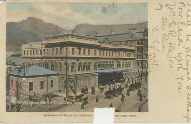
Alice McGREGOR Born: 1908; unknown parents. Possibly adopted by the Salter family? Electoral Roll 1936: Highland Terrace Kangaroo Flat. Alice Mary Salter and William Robert Salter living together; presumed to be sister and brother. William Robert Salter was killed in a MVA in Bendigo in 1937 aged 26. In Victoria in 1938, Alice Mary Salter married James Thomas McGregor (born Victoria 1917, died Victoria 1983, buried Fawkner Cemetery) Lived: 1968; 22 Wade Street Golden Square Alice McGregor Died: 1999 aged 91 at Anne Caudle Centre, Bendigo Buried: Kangaroo Flat Cemetery See additional research. Postcard Album of Alice McGregor contained 86 post cards.Postcard Album of Alice McGregor containing 86 post cards. See 1400 Colour photo of the Railway Station, Alderley Street, Cape Town, South Africa. Horse drawn vehicles and pedestrians on the street. kground Addressed to Miss A. Stapleton, Arcade, Bendigo, Victoria, Australia Sender - Mrs. E.R. De Low, Hex River, Cape Colony, S. Africa Not dated postcard, collector, alice mcgregor -
 Bendigo Historical Society Inc.
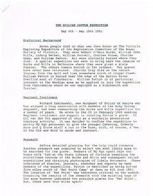
Document - THE WILLIAM PATTON Burke and Wills EXPEDITION MAY 4 - 19 1991
Typed notes on an expedition by Army personnel and Richard Zakrzewski to find the grave of William Patton who was buried near the edge of the Bulloo River Overflow east of Tibooburra. He was a member of the Burke and Wills Party. Notes mention planning for the expedition and what they did while they were there. C. E. Burgess WO2, the author of the notes.document, the william patton expedition may 4 - 19 1991, the victoria exploring expedition of the exploration committee of the royal society of victoria, robert o'hara burke, william john wills, ludwig becker, william purcell, charles stone, charles gray, william patton, richard zakrzewski, army survey regiment, burke and wills expedition, lt col van den tol, state library of victoria, land information centre bathurst, capt. coulthard, wo1 slater, wo2 burgess, sgt de grauw, lcpl blake, capt cuskelly, wo1 gillies, ssgt sustart, cpl colde, cpl south, lcpl northausen, spr linwood, wo2 graham, ssgt gowers, sgt marshall, cpl doyle, cfn ellis, spr reynolds, spr hilbig, pte mckersie, 10/27 rsar, clifton downs homestead, gwen smith, william patton memorial -
 Vision Australia
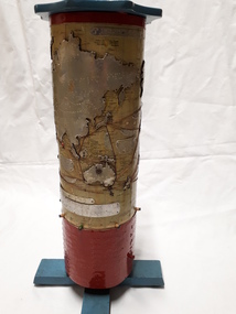
Map - Object, R.F. Tunley, Braille cylinder map, 1940-1950s
This map was produced by Richard Francis Tunley and given to the Victorian Braille Library for use by it's patrons. Mr Tunley was a prolific Braille map maker as well as producing other items for blind and vision impaired children, advocated for compulsory education for blind and deaf children and established the Queensland Braille Map and Model Club. Leading by example, his maps were treasured by those who used them and were an outstanding piece of craftsmanship. In this example, the metal cylinder sits on a wooden base and can be turned via a handle in the wooden top or rotating the sides. A brailled red metal plate occupies the bottom third, and large continents have a metal plate, cut to shape, upon which braille country/continent names are placed. Major rivers are traced through raised lines in the metal continental plates, twisted wire traces shipping routes with associated brailled metal plates, raised metal pins in some major locations and more explanatory plates sit in various oceans.1 metal cylindrical map with tactile markersCommercial & Strategic Map of the British Empire Presented to the Victorian Braille Librarybraille library of victoria, r.f. tunley -
 Lakes Entrance Historical Society
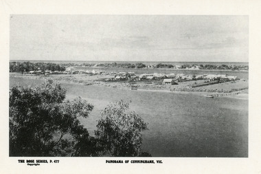
Postcard - Township, Rose Series, 1910c
Plus black and white enlarged copy 15x25Black and white postcard. It shows the rear view of the buildings which front the Cunninghame Arm, or Reeves River, one cottage and three jetties on North Arm, sand hummocks of South shore of Cunninghame Arm and Bass Strait in background. Double storied Kelvin House, later Maranui and Methodist Church identified. Lakes Entrance VictoriaPanorama of Cunninghame Victopography, waterfront, township -
 Melbourne Tram Museum
Booklet, Melbourne & Metropolitan Tramways Board (MMTB), "Tramps between tram termini", c1930
Booklet - promoting tram travel and walking trips or "tramps" between various tram terminus. Includes notes on the Board's services, its tourist tram with notes and fares on specific walks. Includes a map and some photos for each walk. 1 - Brighton Road to Hawthorn 2 - Burwood to Mont Albert 3 - Carnegie to Darling Road 4 - Whitehorse Road to East Kew 5 - Glen Iris to Darling Road 6 - Maribyrnong River to Mt Alexander Road 7 - Gardiner or Glen Iris to Burwood 8 - Wallen Road Bridge to Glenferrie Road 9 - Johnston St Bridge to Victoria Bridge At the time, some of these walks would have been through largely undeveloped land and parks.Demonstrates a promotion of the MMTB tram services and leisure activities.Booklet - 16 pages, two colours on light fawn paper, centre stapled.tramways, showgrounds, william st, mmtb -
 Montmorency–Eltham RSL Sub Branch
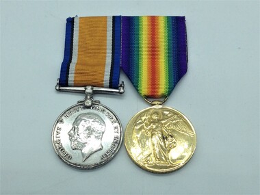
Medal - Medal Group, WW1, 2166 Lieutenant Reginald Frank Barratt
Information from "The AIF Project" Lieutenant Reginald Frank Barratt was born in 1879 in Withington, Manchester, Lancashire, England. Regimental number 2166. 3rd Field Artillery Brigade, Military District 3 and Military District 6. Arrived in Australia in 1903 aged 24. Address was Mount Street, Heidelberg, Victoria. Occupation - Farmer. Enlistment date was 17th August 1914. Served with the 68 Battery Royal Field Artillery during the South African War. Rank on enlistment was Sergeant. Embarkation details - Unit embarked from Melbourne, Victoria on board Transport A2 Geelong on 19th September 1914. Rank Lieutenant - Unit 1st Divisional Ammunition Column. Information from the Roll of Honour - Awarded Royal Human Society Medal for saving three lives from drowning in Orange River during South African War. Wounded at Zillebeke, near Ypres, Belgium. Died of wounds 22nd August 1917 at the age of 38. Buried at Bedford House Cemetery, Enclosure No 2, (Plot 1, R0w F, Grave 23), Zillebeke, Belgium. Panel number , Roll of Honour Australian War Memorial British War Medal - The medal was struck by the Royal Mint, is a silver disc 36mm in diameter with a straight clasp suspended without swivel. The obverse shows Sir Bertram Mackennal's bare headed effigy of King George V facing left with the legend 'GEORGIVS V BRITT:OMN:REX ET IND:IMD - "George V, King of all the British Isles & Emperor of India". The reverse, designed by William McMillan, shows St George, naked on horseback and armed with a short sword, an allegory of the physical & mental strength which achieved victory of Prussianism. The horse tramples on the Prussian eagle shield and the emblems of death, a skull and cross bones. In the background are ocean waves and just off centre near the right upper time is the risen sun of victory. The years 1914-1918 appear on the perimeter in the left and right fields respectively. The watered silk ribbon is 32mm wide with 3mm wide royal blue band, 2mm wide black band, 3mm wide white band repeated in reverse order and separated by 16mm wide orange band. Victory Medal - The medal is bronze disc 36mm in diameter with a winged figure of Victory on the obverse. The reverse has the words 'THE GREAT WAR FOR CIVILIZATION 1914-1918', all surrounded by a laurel leaf. The watered silk ribbon is 32mm wided has two rainbow design with the violet from each rainbow on the outside edges, moving through to a central red stripe where both rainbows meet.The recipients name, rank and unit are impressed on the bottom edge of the medals - Lieut F Barratt AIF -
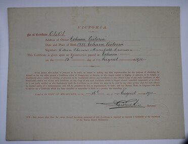
 Port of Echuca
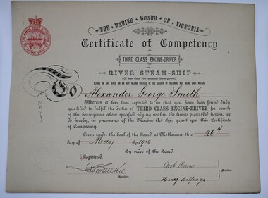
Certificate (Item) - Certificate of Competency - Third Class Engine Driver, The Marine Board of Victoria, Alexander George Smith, 22-5-1902
... competency exam to operate a vessel on the Murray River. Certificate ...From the 1870s Captains were required to sit a steamship competency exam to operate a vessel on the Murray River. Certificate states that Alexander George Smith was born in Echuca Victoria in 1869 and passed examination 22/5/1902.captains, murray river captains, marine board of victoria, certificate of competency, marine act 1890, third class engine-driver -
 Port of Echuca
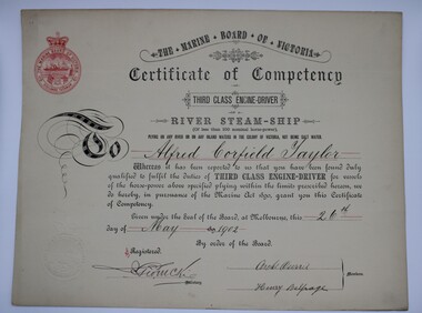
Certificate (Item) - Certificate of Competency - Third Class Engine Driver, Alfred Corfield Taylor, 22-5-1902
... competency exam to operate a vessel on the Murray River. Alfred ...From the 1870s Captains were required to sit a steamship competency exam to operate a vessel on the Murray River. Alfred Corfield Taylor was born in Echuca in1869 and passed examination 22/5/1902captains, murray river captains, marine board of victoria, certificate of competency, marine act 1890, third class engine-driver -
 Port of Echuca
Certificate (Item) - Certificate of Competency - Master, William Tomas Mansfield Freeman, 16-8-1910
... Murray River Marine Board of Victoria Certificate of Competency ...From the 1870s Captains were required to sit a steamship competency exam to operate a vessel on the Murray River. William Tomas Mansfield freeman was born in Echuca in 1888.Valid on River Murray & Tributariescaptains, murray river, marine board of victoria, certificate of competency, marine act 1890, master -
 Bacchus Marsh & District Historical Society
Map, Lerderderg Park Lands sale plan. 1911
This plan was for the sale of parcels of land from the Lerderderg Park Estate property in 1911. Advertising for the sale appeared in the Bacchus Marsh Express newspaper through July of 1911. The property was situated only a few kilometers from the township of Bacchus Marsh. The agents for the sale were L. A. Fairbairn & Co.Lerderderg Park Estate was a significant and early colonial property in the Bacchus Marsh area. This plan provides details about the first time the property was subdivided for sale. It is therefore documents an important moment in the history of this property and the broader trend of the subdivision of older and larger properties in the district.A single page paper plan showing allotments of land for sale from the Lerderderg Park property owned by John Wills. The parcels of land for sale are coloured in red.The Lerderderg River and Pyke's Creek Irigation Channel shown on the plan are in blue ink. The rest of the plan is a dark cream or beige colur with the text in black ink. The plan has been extensively annotated with hand-written notes indicating the names of people who purchased the various parcels of lands and the prices paid for those lands. Part of the top of the plan containing some text appears to be missing. The plan is pasted into a bound volume containing 76 maps or plans in total. Top: Have received instructions to Sell, account Mr John Wills, his renowned LERDERDERG PARK LANDS, so well and favourably known throughout the Commonwealth. In areas from 3 acres to 1276 acres. Every lot is either rich lucerne land (or portion now under lucerne) with some higher land adjoining Railway Station, and 2 Milk factories within 2 miles, absolutely the finest land in Victoria. Bottom: THIS IS THE FIRST SUBDIVISIONAL SALE of Rich Flats in Bacchus Marsh since the Pyke's Creek Scheme, and every lot is commanded by it. Only 32 miles from Melbourne.bacchus marsh victoria maps, land sales, lerderderg park estate, land subdivision -
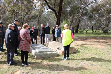 Bendigo Historical Society Inc.
Bendigo Historical Society Walking Tour of Axedale, 1st Sept 2024
Axedale is a town in Victoria, Australia. It is located on the McIvor Highway, in the City of Greater Bendigo, east of Bendigo. It was surveyed and proclaimed in 1861. At the 2021 census, Axedale had a population of 984. The town is nestled alongside the Campaspe River which feeds out of Lake Eppalock. It has a golf course, tennis courts, a school, a pub and a convenience store/petrol station. It lies between Heathcote and Bendigo.Forty Photos taken on the walking tour of Axedale by the Bendigo Historical society. Places visited included the Protestant and Catholic Cemeteries, the "Blue Stone House", the 150-year-old bridge over the Axe Creek on the Sugerloaf Road, the old Cobb and Co Stables, St Andrews Church and the Campaspe River Bridge.axedale, bendigo historical society walking tour, st andrews church axedale, axedale cemetery, axe creek bridge, campaspe, cobb and co stables axedale, blue stone house axedale -
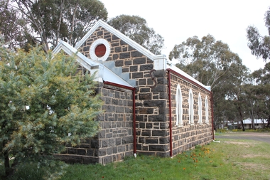 Bendigo Historical Society Inc.
Document - Notes on St Andrews Church Axedale, 1st Sept 2024
Although Presbyterians held religious services prior to 1854 it, was not till that year that Dr Nish arrived in Bendigo. It is known that Dr Nish preached to the shepherds in Axedale, long before the church was built, but where is not known. The foundation stone for the church was lain on September 30th, 1868. Axedale is a town in Victoria, Australia. It is located on the McIvor Highway, in the City of Greater Bendigo, east of Bendigo. It was surveyed and proclaimed in 1861. At the 2021 census, Axedale had a population of 984. The town is nestled alongside the Campaspe River which feeds out of Lake Eppalock. It has a golf course, tennis courts, a school, a pub and a convenience store/petrol station. It lies between Heathcote and Bendigo.Historical Notes on St Andrews Axedale 1868-1968 and the 150th Anniversary Church booklet March 2019.axedale, st andrews church axedale, dr nish -
 Bendigo Historical Society Inc.
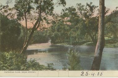
Postcard - Alice McGregor Postcard Collection, 1900 - 1920
Alice McGREGOR Born: 1908; unknown parents. Possibly adopted by the Salter family? Electoral Roll 1936: Highland Terrace Kangaroo Flat. Alice Mary Salter and William Robert Salter living together; presumed to be sister and brother. William Robert Salter was killed in a MVA in Bendigo in 1937 aged 26. In Victoria in 1938, Alice Mary Salter married James Thomas McGregor (born Victoria 1917, died Victoria 1983, buried Fawkner Cemetery) Lived: 1968; 22 Wade Street Golden Square Alice McGregor Died: 1999 aged 91 at Anne Caudle Centre, Bendigo Buried: Kangaroo Flat Cemetery See additional research. Postcard Album of Alice McGregor contained 86 post cards.Postcard Album of Alice McGregor containing 86 post cards. See 1400. Colour photo of a river scene in National Park near Sydney. Trees on both sides of river. Addressed to Miss A. Stapleton, Arcade, Bendigo Sender - not known Dated 25.4.05 postcard, collector, alice mcgregor -
 Bendigo Historical Society Inc.
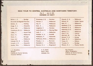
Photograph - PETHARD COLLECTION: PHOTOGRAPH RESO TOUR
George Pethard Collection including references to Taraxale Brewing Company Pty brown covered 29x19mm photographic album bound with gold string / 52 black and white Photographs of Reso tour to central Australia and Northern Territory / includes Aboriginal camps , camel trains / landscapes , war cemetery at Adelaide River / May 13- June 13 1947 / the 40 members of the party are also named includes: George Pethard / Aboriginal camp , Jay Creek consisting of makeshift tents / crowd playing 'Two Up ' Photo of the ship 'Meggs' at Darwin / Manton Dam - Darwin's water supply photo. Reso Tour to Central Australia and Northern Territory.Roy Dunstan Publicity and Tourist services Victoria Railwaysphotograph, person, male, george pethard / taraxale brewing company pty ltd / aboriginal camps / camel trains / war cemetary at adelaide river photo of the ship 'meggs' at darwin / manton dam - darwin's water supply photo -
 Lakes Entrance Historical Society
Book, North East Regional Tourist Authority, North East Victoria, 1980
A brief record of the region from the Murray River in the north to the Dargo High Plains in the south, from Yarrawonga and Wangaratta in the west to the Indi River in the east. Illustrated with coloured photographs.tourism, mines and mining, settlers, water supply -
 Marysville & District Historical Society
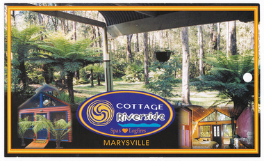
Postcard (item) - Colour postcard, COTTAGE Riverside, Unknown
A colour postcard to advertise accommodation at Riverside Cottages in Marysville.A colour postcard to advertise accommodation at Riverside Cottages in Marysville.Romantic self-contained Riverside Cottages on the Steavenson River Surrounded/ by Stateforest. Hand feed King Parrots from your luxury country Cottage./ A secluded peaceful and romantic getaway yet only 1.2km from main street. MARYSVILLE/ Victoria Australia STAMP www.dreamer.com.au 129 Falls Rd. Marysville Vic 3779 (03)5963-3388 E-mail : [email protected], victoria, australia, riverside cottages, accommodation, postcard -
University of Melbourne, Burnley Campus Archives
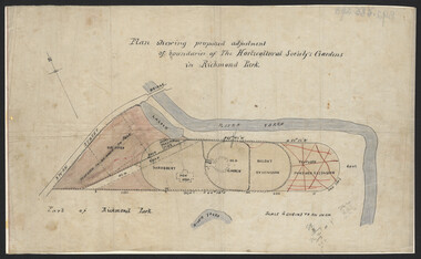
Plan, Plan showing proposed adjustment of boundaries of the Horticultural Society's Gardens in Richmond Park, c.1880-1884
... gardens richmond hoticultural society of victoria River ...Copy of B92.0535 framed and glazed.gardens, richmond, hoticultural society of victoria, river yarra -
Lakes Entrance Historical Society
Book, Anderson Christopher, The Snowy River Floodplains Railway Bridge, 2003
Research interpretation and management recommendations for the Snowy river Flood plains railway bridge, near Orbost East Gippsland victoria by Forestec studentbridges, transport, employment -
Lakes Entrance Historical Society
Book, Synan Peter, Secrets of Ghost Towns of the High Country featuring 50 Ghost Towns in and around Victorias Alpine Region, 1989
A history of the Gippsland Lakes Victoria as a transport system v for trade within the Lakes and River systems and coastal and interstate trade.ships and shipping, land settlement, waterways -
Lakes Entrance Historical Society
Book, Synan Peter, Highways of Water- How shipping on the Lakes shaped Gippsland, 1989
A history of the Gippsland Lakes Victoria as a transport system for trade with in the lakes and river systems, and coastal and interstate tradeships and shipping, land settlement, waterways -
 University of Melbourne, Burnley Campus Archives
Plan, John S. Jenkins, Plan showing proposed adjustment of boundaries of the Horticultural Society's Gardens in Richmond Park, c.1880-1884
Plan on linen fibre cloth. Shows layout of Burnley bound by Swan St., Yarra River and part of Richmond Park, coloured areas showing proposed area to be added to Park, the old road, shrubbery, new hall, old garden, recent extension and proposed further extension (crossed out in red ink). Scale 4 chains:1 inch. Probably drawn by John S. Jenkins, Town Surveyor, Richmond. Has been photographed so that additional copies can be made. On a CD plus 3 negatives, plus small coloured print. (Also copy glazed and framed for Centenary Exhibition - B92.0540.)john s. jenkins, gardens, richmond, hoticultural society of victoria -
 Marysville & District Historical Society
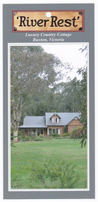
Flyer (item) - Accommodation flyer, 'River Rest', Unknown
... at River Rest cottage in Buxton. buxton victoria australia river ...An information flyer regarding accommodation at River Rest cottage in Buxton.An information flyer regarding accommodation at River Rest cottage in Buxton.buxton, victoria, australia, river rest country cottage, accommodation, flyer -
 Lakes Entrance Historical Society
Photograph - Snake Island, 1950c
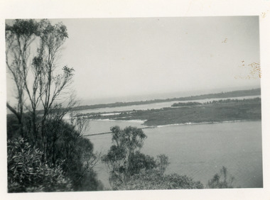
... Island, Snake Island, and dunes at Lakes Entrance, Victoria..., Snake Island, and dunes at Lakes Entrance, Victoria. Reeves ...Also two other copies 7 x 11Black and white photograph showing eastern end of Rigby Island, Snake Island, and dunes at Lakes Entrance, Victoria. Reeves River below, foreground bushes, Hopetoun Channel in middle distance, Bass Strait in distance. waterways, topography, islands -
 Lakes Entrance Historical Society
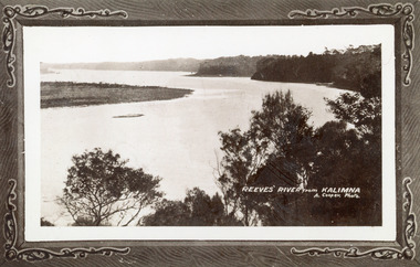
Photograph - Reeves River, 1910c
... Victoria Photograph Reeves River ...Also another copy print 8 x 13, both printed as though framedBlack and white photograph of Reeves Channel, Gippsland Lakes. It shows Rigby Island opposite the steep cliffs of mainland shore. Small island off Rigby was known as the Doughboy. Taken from Jemmys Point, natural vegetation in foreground. Lakes Entrance VictoriaReeves River from Kalimnaislands, waterways, topography -
 Eltham District Historical Society Inc
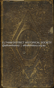
Book - Family Bible, King James Version, Aug. 1834
King James Bible published Aug. 1934 Family Bible of Robert William Whatmough and Mary Whatmough (nee Hill), married August 4, 1839 in Manchester, Lancashire, England and migrated to Australia with baby daughter Jemima, arriving Port Phillip Bay 19 February 1841. Inscribed in ink on inside front cover: Jemima Whatmough born January 18th 1840 on Saturday Hemmet Whatmough born March 26th 1842 on Saturday Job Whatmough born May 11th 1844 Saturday Died April 12th 1845 Sarah Whatmough born September 17th 1845 James Whatmough born June 28, 1847 Died February 1st 1848 Margaret Whatmough born June 15th 1848 Died March 24th 1850 Jessy Whatmough born January 26, 1851 Inscribed in ink on inside front cover facing page: William Jordison’s Thirty knoul (?) Bok (?) 25th – 1839 ROBERT WHATMOUGH BOOK Presented by Mr. Ferguson Robert Whatmough Presented By the Teacher Mary Ann Whatmough born September 4th 1853 Died November 11th Friday 1853 Benjamin Whatmough born 25 July 1854 Died January 2 1855 Inscribed in ink on inside rear cover facing page over: 1852 This Book Belongs to Mr. Robt. Whatmough On the River Plenty September 16th And in pencil: presented by mr sanger Jemima Whatmough married Robert Fielding on June 23, 1859 at Fitzroy, Victoria According Steve Whatmough (and sister Barbara, email 5/10/2024), Hemmet Whatmough was known as Robert Emmett Whatmough and was always refered to as Emmett within the family.benjamin whatmough, holy bible, james whatmough, jemima fielding (nee whatmough), jessy whatmough, job whatmough, margaret whatmough, mary ann whatmough, mary whatmough (nee hill), robert whatmough, robert william watmough, sarah whatmough, tom fielding collection, plenty river, pioneer family, hemmett whatmough, robert emmett whatmough -
 Lakes Entrance Historical Society
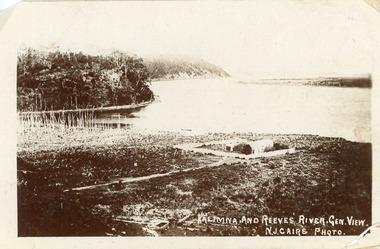
Postcard - Maringa Creek, Caire Nicholas John, 1900c
Also three black and white copies 17 x 25First generation black and white postcard of the Kalimna area of the Gippsland Lakes. It shows a residence surrounded by a paling fence at Maringa Creek in foreground, dead vegetation at mouth of creek. Steep cliffs of lake shore opposite low lying Rigby Island. Lakes Entrance VictoriaKalimna and Reeves River. Gen View.waterways, topography -
 Lakes Entrance Historical Society
Photograph - Foreshore Lakes Entrance, Bulmer H D, 1923c
Second copyBlack and white photograph showing aerial view of the entrance to the Gippsland Lakes, shows Cunninghame Arm, North Arm, Reeves River and Hopetoun Channel, Rigby Island and Snake Island, the barrier on right foreground. Lakes Entrance Victoriawaterways, islands, aerial photograph, fishing industry, coast -
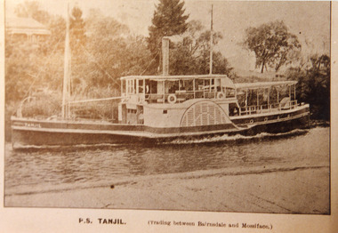
 Lakes Entrance Historical Society
Photograph - Transport, 1900 c
Black and white photograph showing tug boat Tarra and barge Tambo unloading wool from Ensay, via Mossiface, at wharf on Mitchell River. Wharf, sheds and butter factory in background. Bairnsdale Victoriaships and shipping, waterways, transport -
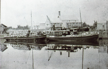
 Lakes Entrance Historical Society
Photograph - P.S. Tanjil, 1910 c
Sepia photograph of postcard showing P S Tanjil in the Mitchell River Bairnsdale Wharf, house on rise opposite the wharf. Wharf decking across bottom of photo. Vegetation and pine trees on river bank. Tanjil travelling upstream. Bairnsdale VictoriaP.S Tanjil (Trading between Bairnsdale and Mossiface)ships and shipping, waterways, trading