Showing 10615 items
matching sites
-
 Kew Historical Society Inc
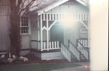
Photograph - 1st Kew Scout Hall, Disraeli Street, 1992
The 1st Kew Scouts was one of the first Scout Troops in Victoria, being formed in 1909. From 1927 they met in a magnificent Scout Hall in Disraeli Street, Kew until it was demolished in 1993. Still operating (in 2020) from their new Scout Hall on the corner of Kilby Road and Kellett Grove, Kew.Original colour positive photograph of the 1st Kew Scout Troop's single-storey wooden hall in Disraeli Street, Kew, prior to the building's demolition and the relocation of the troop to a new site."1st Kew Scout Hall"scout troops -- kew (vic.), 1st kew scouts, scout halls -- kew (vic.), scout halls -- melbourne (vic.), boy scouts -
 Kew Historical Society Inc
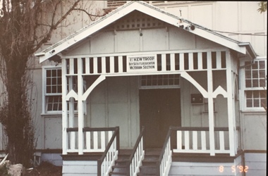
Photograph - 1st Kew Scout Hall, Disraeli Street, 1992
The 1st Kew Scouts was one of the first Scout Troops in Victoria, being formed in 1909. From 1927 they met in a magnificent Scout Hall in Disraeli Street, Kew until it was demolished in 1993. Still operating (in 2020) from their new Scout Hall on the corner of Kilby Road and Kellett Grove, Kew.Original colour positive photograph of the 1st Kew Scout Troop's single-storey wooden hall in Disraeli Street, Kew, prior to the building's demolition and the relocation of the troop to a new site."1st Kew Scout Hall / Cr Disraeli and Childers St North Kew. Demolished ... Re-established Cr Kilby Rd & Kellett Grove. Nth Kew .."scout troops -- kew (vic.), 1st kew scouts, scout halls -- kew (vic.), scout halls -- melbourne (vic.), boy scouts -
 Kew Historical Society Inc
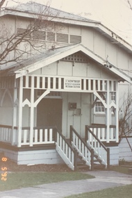
Photograph - 1st Kew Scout Hall, Disraeli Street, 1992
The 1st Kew Scouts was one of the first Scout Troops in Victoria, being formed in 1909. From 1927 they met in a magnificent Scout Hall in Disraeli Street, Kew until it was demolished in 1993. Still operating (in 2020) from their new Scout Hall on the corner of Kilby Road and Kellett Grove, Kew.Original colour positive photograph of the 1st Kew Scout Troop's single-storey wooden hall in Disraeli Street, Kew, prior to the building's demolition and the relocation of the troop to a new site."1st Kew Scout Hall / Cr Disraeli and Childers St North Kew. Demolished ... Re-established Cr Kilby Rd & Kellett Grove. Nth Kew .."scout troops -- kew (vic.), 1st kew scouts, scout halls -- kew (vic.), scout halls -- melbourne (vic.), boy scouts -
 University of Melbourne, Burnley Campus Archives
Plan - Sketch, Plan of Burnley Gardens, 1970-1980
Plans A and B. 2 identical hand drawn sketch plans of area bounded by manure bins, pumphouse to the east, milking shed and silo to the west: showing all buildings on the site.burnley gardens, buildings, burnley school of horticulture -
University of Melbourne, Burnley Campus Archives
Plan, Kirsten Strutt, Central Gardens Hawthorn, 1996
Plans by Kirsten Strutt (student) for Hawthorn City Council. Scale 1:500. (1) Site Analysis September 1986. (2) Tree Survey October 1986 Drawing No 2.kirsten strutt, hawthorn, gardens, central gardens hawthorn -
University of Melbourne, Burnley Campus Archives
Letter - l, 2019
john dallachy, horticultural society of victoria, burnley gardens -
Canterbury History Group
Ephemera - 3a View Street Canterbury, 1997
Real estate advertisement for auction of 3a View Street Canterbury on 26 July 1997. includes coloured photograph of the exterior of the residence, two interior views, floor and site planscanterbury, view street, sinclair & co -
Canterbury History Group
Ephemera - Entertaining will be a delight!, [2004]
Real estate advertisement for the sale by auction of 30 Monomeath Avenue Canterbury on Saturday 6 November [2004]. Includes coloured photographs of the interior and exterior of the house and floor and site plans.canterbury, monomeath avenue, swimming pools, peacock family -
Canterbury History Group
Ephemera - Unit 3/172 Mont Albert Road Canterbury, [1992]
Real estate advertisement for the sale by auction of Unit 3/172 Mont Albert Road Canterbury on Saturday 11 July [1992] Includes a sketch of the unit and a floor and site plan.canterbury, mont albert road, home units -
Canterbury History Group
Ephemera - 32 Victoria Avenue, Canterbury, [1999 or 2004]
Real estate advertrisement for the sale by auction of 32 Victoria Avenue Canterbury on Saturday 4 December [1999 or 2004]. Includes a coloured photograph of the exterior of the house and floor and site plans. -
Canterbury History Group
Ephemera - 42 Wattle Valley Road Canterbury, [2010]
Real estate advertisement for the sale by auction of 42 Wattle Valley Road Canterbury on Saturday 11 September {2010]. Includes coloured photographs of the interior and exterior and floor and site plans.canterbury, wattle valley road, edwardian style, swimming pools, back yards -
Canterbury History Group
Ephemera - 3/45 Wattle Valley Road Canterbury, [2002]
Real estate advertisement for the sale by auction of 3/45 Wattle Valley Road Canterbury on Saturday September 7 [2002] Includes a sketch of the exterior of the building and a floor and site plan.canterbury, wattle valley road, home units -
Canterbury History Group
Photograph - The site of the new Canterbury Baptist Church, 1961
Black and white photograph copied by Jan Pigot from the album kept at the church, of the site of the new Canterbury Baptist Church in Balwyn Road after demolition of the old church in 1961.canterbury, balwyn road, canterbury baptist church, construction sites, churches -
Canterbury History Group
Ephemera - Unit 1, 12 Chatham Road, Canterbury, [1997]
Real estate advertisement for the sale by auction of Unit 1, 12 Chatham Road Canterbury on Saturday 15 March [1997] Includes sketch of the exterior of building and floor and site plancanterbury, chatham road, home units -
Canterbury History Group
Ephemera - A magical reminder of an enchanting era, [1999]
Real estate advertisement for the sale by auction of 26 Chaucer Crescent Canterbury on Saturday 27 November [1999]. Includes coloured photographs of interior and exterior of the house and floor and site planscanterbury, chaucer crescent, edwardian style, swimming pools -
Canterbury History Group
Ephemera - Canterbury, 39 Matlock Street, 1/08/2013 12:00:00 AM
Advertising material for the sale of 39 Matlock Street Canterbury by Fletchers .Auction on Saturday 24th August 2013 Includes coloured photographs of the interior and exterior of the house and a floor and site plancanterbury, matlock street, edwardian style -
 Falls Creek Historical Society
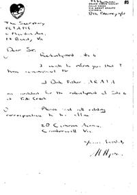
Letter - Hand-Written - Redevelopment Site 4, 08.02.1962
Bob (Herman) Hymans (a former member of the Royal Netherlands Navy) was born in Bloemendaal, Holland on 30th September 1922. During World War II he fought against the Japanese in the Dutch East Indies (now Indonesia) and was imprisoned in Changi and on the Burma Railway. After gaining qualifications as a Ski Instructor, Bob arrived in Falls Creek in July 1950. Working as an Instructor and Supervisor at Bogong Lodge, Bob decided his future was in accommodation. He was successful in negotiating an indenture for land from the State Electricity Commission (SEC). It took Bob two years to build his Grand Coeur Chalet but, tragically, it was burned down in August 1961. Bob also built the first Chairlift in Australia. This was a single chairlift and the structure was built from wooden electricity poles. He was constantly full of new ideas and proposals for the village. Bob Hymans die on 7th July 2007. This Collection of documents and letters tells the story of Bob's endeavours to develop Falls Creek into the ski village it is today.This letter is significant because it reflects the relationship between Bob Hymans and the Management Committee.A handwritten letter from Bob Hymans notifying the Management Committee that he has appointed an architect for the redevelopment of Site 4. All correspondence was to be directed to J. Fisher in Camberwell, Victoriafalls creek tourist area management committee, chairlift site 3, bob hymans -
 Kilmore Historical Society
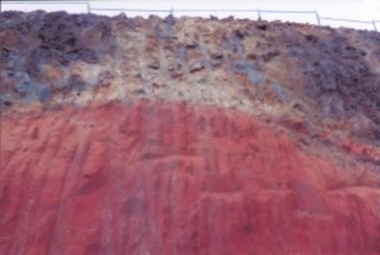
Photograph, 91 Sydney Street, July 2016
15cm x 10cm coloured photograph of the cutting at 91 Sydney Street, Melbourne Street at the top of the cutting which exposed the volcanic rock. Now is the site of the car wash and KFC.Written on the back: Exposed volcanic rock 91 Sydney St Kilmoreconstruction -
 Kilmore Historical Society
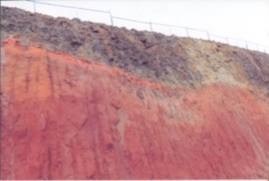
Photograph, 91 Sydney Street, July 2016
15cm x 10cm coloured photograph of the cutting at 91 Sydney Street, Melbourne Street at the top of the cutting which exposed the volcanic rock. Now is the site of the car wash and KFC.written on the back of .1: cutting @ 91 Sydney St Kilmore Melbourne St 2 top of cutting late July 2016 Written on the back .2: Exposed volcanic rock look south west 91 Sydney St Kilmore late July 2016construction -
 Port Melbourne Historical & Preservation Society
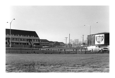
Photograph - Corner The Boulevard and Beacon Road, Andrew U'REN, C. 1970s - 1980s
From a box of photographs in Nancy U'REN's papers used during research for her thesis, The Early Growth and Development of Sandridge (1976) and/or her book with Noel TURNBULL, A History of Port Melbourne (1983). The print was probably made by her son, Andrew U'REN, and he may have also taken the photograph.Black and white photograph of the corner of The Boulevard and Beacon Road from the foreshore looking towards the city. The flats are on the left and the BP refinery site is on the right. There is a large white border at the bottom.A star in blue ink on the front. Type of photographic paper and exposure details on the reverse.built environment - domestic, the boulevard, beacon road, bp australia, nancy u'ren nee morris -
Canterbury History Group
Ephemera - A californian in Canterbury, 2003 or 2008
Real estate advertisement for the sale by auction of 113 Canterbury Road Canterbury, on 20 September [2003 or 2008] Includes coloured photographs of the exterior and interior of the house and floor and site plans.canterbury, canterbury road, swimming pools, californian bungalows -
Port Melbourne Historical & Preservation Society
Audio - Radio Interviews, Dr Kim Dovey, Robert Peck, Greg Flynn re Sandridge City Development plan, 27 Nov 1991
Radio interviews with Dr Kim Dovey, Robert Peck, Greg Flynn, re the Sandridge City plan and the cleanup of the site. Recording 27.11.1991 and other dates, duration 30:48town planning - proposals shelved, dr kim dovey, robert peck, greg flynn -
 Melbourne Tram Museum
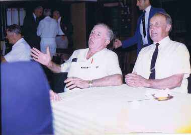
Photograph - Colour Photograph/s, Mar. 1985
Colour print of Fred Turner (left) and ?? Allan - siting at a table on "Party night on final night of interstate tramway bowling tournament in Brisbane - March 1985" Printed on Fujicolour paper.In ink on rear "Party night on final night of interstate tramway bowling tournament in Brisbane - March 1985"trams, tramways, personnel, sports, bowls -
 Lakes Entrance Regional Historical Society (operating as Lakes Entrance History Centre & Museum)
Photograph, 2008
This is the after photograph use in the 150 year display called Lakes Entrance 1858-2008 held in 2008.Colour photograph of the Banjo Patterson Motel, a white mexican style building with balcony, cars parked in front, it is situated on Esplanade on the site of Broomes Federal Hotel. Lakes Entrance Victoriaguesthouses, architecture, waterfront, transport, room display -
 Lakes Entrance Regional Historical Society (operating as Lakes Entrance History Centre & Museum)
Photograph - Pecks factory, Fish Marie, 1995c
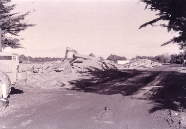
Black and white photograph, heavy machinery clearing the site of Pecks fish processing factory on Bullock Island, showing piles of broken concrete ready for removal. Lakes Entrance Victoriaislands, historic site -
 Kiewa Valley Historical Society
Photograph - Folder of Photographs – Photocopied set of black and white photographs (pages 39 - 48) from the display folder put together by KVHS to document life on the Kiewa Valley Hydro-electric Scheme
Although the Kiewa Hydro-Electric Scheme was first proposed in 1911, construction did not commence until 1938. As part of the push to cut electricity costs and diversify supply, the Victorian Government (circa 1930) initiated the conversion from primarily brown coal supply to hydro – electricity. Field investigations during the 1940’s resulted in a new proposal for a scheme that had more than double the capacity of the 1938 scheme. The Kiewa Hydroelectric Scheme became the largest scheme of its kind in the State Of Victoria and the second largest scheme in Australia. The number of personnel involved in the planning and construction of the scheme increased dramatically. During the late 1940’s, most activity centered around the construction of the West Kiewa Power Station, Rocky Valley Reservoir, McKay Creek Power Station and the Bogong Creek Aqueduct.A common thread across all the larger hydro scheme constructions was the need for workers, both qualified and unqualified who came from around the world seeking a new life for themselves and their families. New accommodation and facilities were required for the army of workers engaged in construction in often remote and wild areas. The SEC had a high demand for timber, and set up the first of a number of sawmills at Bogong Creek in 1939 and set up the first hardwood logging in the headwaters of the Kiewa River. These new ‘towns’ such as Mt Beauty and Bogong, survived, serving the needs of operational personnel and their families, and expanding with growth of new industries. Mount Beauty, and to a lesser extent Bogong, are among these places. Large A3 size spiral bound display folder containing photocopied black and white photographs of various aspects of the early days of the Kiewa Valley Hydro-electric scheme including equipment, various work sites and photographs of workers and their families. 1-Breakdown in Circuit Breaker (Isolating Contacts) 2-Big Hill Bench- Site of No 5 Devlopment 3-No 1 Power Station 4-No 1 Pipeline, Anchor No 8 5-Push Dozing-RD8 Tractor 6- Tractor and driver at work 7- Workmen in unnamed tunnel 8- Front page of Journal of SECV Vol 15. Photograph of No 1 pipeline viewed from McKay Portal 9-Rocky Valley Dam Core Wall 10-Workmen working inside tunnel loading rocks into a rail truck. 1-Breakdown in (generator) Circuit Breaker (Isolating Contacts) Handwritten underneath (This is not a picture of any part of a generator. It is a circuit breaker Signed Ron White Ron was the Principal Hydro Engineer of the SEC Kiewa Scheme Page number 39 2-Big Hill Bench – Site of No. 5 Development (abandoned) Page number 40 3-No 1 Power Station Page number 41 4-No. 1 Pipeline, Anchor No. 8 Page number 42 5-Push Dozing – RD8 Tractor, 12 cubic yard Carryall and FD Cletrac Tractor Page number 43 6-No marking Page number 44 7-No marking Page number 45 8-Journal of State Electricity Commission of Victoria SEC Vol 15 No… April-May, 19… No 1 Pipeline-A view from McKay Portal G Hempenstall and D Sutton stiffening pipe section for transport during construction (….indicates missing text) Page Number 46 9-Rocky Valley Dam Core Wall Page number 47 10-No markings Page number 48 secv; kiewa hydro electric scheme; construction area; power stations; reservoirs; aqueduct; mt beauty; bogong -
 Bendigo Historical Society Inc.
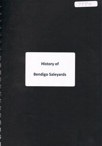
Document - ''HISTORY OF BENDIGO SALEYARDS''
''History of Bendigo Saleyards''. This document is comprised of a paper titled 'Going, Going, Gone'' and as a history of the saleyards, appears to have been written /authorized by Mr John Quinlan (Convenor, Historical Field Day Committee, Department of Agriculture) see covering letter from C C Campbell, City Engineer. Covers history from 1861; reference to abattoirs on site; railway spur; Country Roads Board; Wellsford Forest site; Marong site. Other part of document is a list of various dates with short description of activity for that year from 1861 to September 1984 - this list is by M (Malcolm) Styles of City Engineers Department. Reference to Bendigo East Bowling Club; Bendigo East Swimming Pool.Mr John Quinlanbendigo, business, bendigo saleyards, mr a.m. lloyd, bendigo east bowling club, bendigo east swimming pool. -
 Port Melbourne Historical & Preservation Society
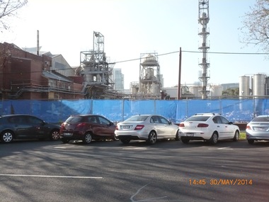
Photograph - Exterior views, J Kitchen & Sons, Port Melbourne, 2011 - 2014
External views of the J Kitchen & Sons site. Some taken October 2011 when manufacturing still occurred on site and some in May 2014 after demoltion work had begun to clear the site for future development; (.01) The Australian Academy of design building at 220 Ingles St (October 2011) (.02) The building which housed the factory outlet shop. Admin building in background. (October 2011) (.03) Part of the Iindustrial complex surrounded by fence in preparation for demolition. (May 2014) (.04) View of the art-deco admin building taken from Ingles St (May 2014) (.05) Corner of the complex already cleared (former shop outlet) (May 2014)built environment - industrial, business and traders - soaps/candles, j kitchen & sons pty ltd, australian academy of design, ingles street