Showing 16611 items
matching bay-bridge
-
 City of Ballarat Libraries
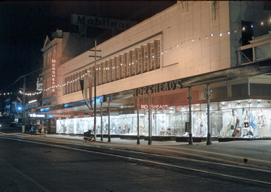
35mm Slide, Morshead's Department Store, Bridge Street Ballarat, circa 1950s
Morshead's was a popular department store in the 1950s and 1960s. In this night exposure the famous window displays can be clearly seen. Also at the extreme right of the photograph the verandah over 'the bridge' can be seen - the creek is covered over making an arcade. Also the verandah posts which were all removed in the 1960s and cantilevered verandahs installed throughout Ballarat. Mrs Bon Strange and her husband Bert were well known Ballarat residents. When Mrs Strange died some years ago, her extensive slide collection was sorted through and those relevant to Ballarat were gifted to the Ballarat Library. bridge street, department store, trams, illuminations, shop windows, advertising -
 Orbost & District Historical Society
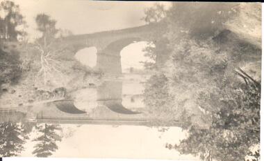
black and white photograph, 1918
Tonghi Creek is 66km north - west of Orbost. Prior to the sealing of the Princes Highway west of Orbost, the road surface was anything but good, even by C1917 when cars started to use the road. From Orbost the old road via Marlo to Sydenham was abandoned for the new location which traversed more rugged country via Cabbage Tree, Bell Bird and Club Terrace to Cann River, and the reason for this diversion was on account of settlements being established at Murrungowar and Club Terrace, at which latter place there was a temporary rush to obtain gold. This road was constructed by the Public Works department and a maximum grade of 1 in 19 was adopted, and as speed was not to be catered for the grade followed in and out round the spurs and gullies, resulting in a maze of turns and twists which required a good deal of skill on the part of the horse driver to negotiate." - Bairnsdale Advertiser, Friday, May 2, 1947. (More information from Newsletter February 2010)This item is a pictorial record of roads in the early 20th century in East Gippsland.A large black / white photograph of a bridge over a small creek, surrounded by bush. The photograph is mounted on a thick cream coloured card.on back - "Bridge at Tonghi Creek 1918"tonghi-creek-bridge country-roads-east-gippsland -
 Lakes Entrance Regional Historical Society (operating as Lakes Entrance History Centre & Museum)
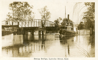
Postcard, 1925
Note on back dated Christmas 1926Sepia postcard showing steamer Omeo passing through opened swing bridge on Latrobe River at Longford near Sale, Victoria.Swing Bridge, Latrobe River, Saleships and shipping -
 Ballarat Tramway Museum
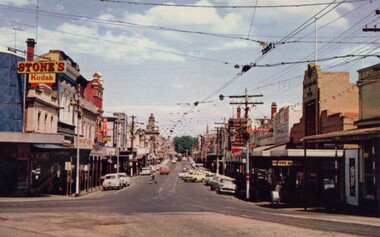
Photograph - Digital Image, Bridge Street
Yields information about the appearance of Bridge St early 1960's and the buildings on either side. Shows the festoon lighting.Digital Copy of a photograph sourced by Roger Greenwood as part of his work on the production of a Video Tape on Ballarat's trams. Photographer and source details not provided by Roger. See btm6304doc.pdf Image looking west along Bridge St Ballarat with the festoon lighting in position. See Reg Item 6303i. This image appears to be early 1960's, possibly a bogie tram with yellow stripping at the Grenville St end, but not the large white stripe. Has the Stones Corner and The State Bank buildings in the view. Photo from a postcard, published c1967 as advised in the e-mail of 20/7/15. Print in box 13 trams, tramways, bridge st, stones corner, main road -
 Hume City Civic Collection
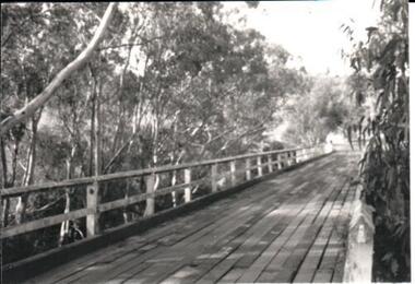
Photograph, late 1970s
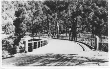
The photograph was taken before the wooden Holden Bridge which spans an arm of the Deep Creek at Bulla was replaced by a more sunstantial concrete structure. As well as building a new bridge, the sharp bend and approach to the old bridge was also removed.A black and white photograph of a wooden road bridge with eucalypt trees growing on either side of the bridge.bridges, holden bridge, shire of bulla, george evans collection -
 The Beechworth Burke Museum Research Collection
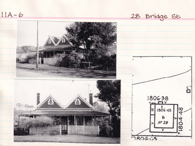
Card (Series) - Index Card, George Tibbits, 28 Bridge Street, Beechworth, 1976
George Tibbits, University of Melbourne. Faculty of Architecture, Building and Town & Regional PlanningIndex system that support the research for Beechworth : historical reconstruction / [by] George Tibbits ... [et al]Arranged by street names of BeechworthEach index card includes: street name and number of property, image of property, allotment and section number, property owners and dates of ownership, description of the property according to rate records, property floor plan with dimensions.beechworth, george tibbitsbeechworth, george tibbits -
 Orbost & District Historical Society
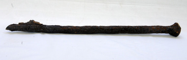
bridge spike
This spike came from the old Brodribb River bridge which is about 9.6 kilometres from Orbost. The Brodribb River joins the Snowy River north of Marlo. In 1906, a bridge replaced the punt over the Brodribb River, improving communication with Orbost. It was eventually replaced by a reinforced concrete bridge built by the Road Construction Authority in 1989 where the Princes Highway passes over the Brodribb RiverThis item belongs to a significant local structure which has been replaced.A very rusty iron bridge spike from the old Brodribb Bridge.brodribb-river bridge-spike -
 Flagstaff Hill Maritime Museum and Village
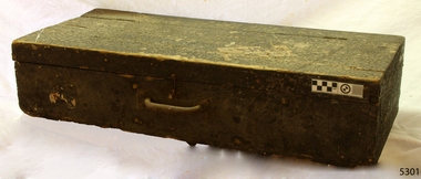
Equipment - Toolbox, ca. 1922
This toolbox was part of the equipment of the coastal trader Reginald M. It is typical of general-purpose toolboxes of the early 20th century. The covering of pitch on the outside was likely to be a form of waterproofing and protection. The vessel “Reginald M” was a two-masted coastal ketch, owned and built by Mr Jack (John) Murch of Birkenhead, Port of Adelaide, South Australia. Its construction took approximately 6 months and it was launched at Largs Bay in 1922. The vessel had many owners and adventures over the years until it was purchased by Flagstaff Hill Maritime Museum & Village in 1975. It was then used as an active display until 2016. Visitors could go aboard, turn the ship's wheel, go below deck and get the feel of the captain's quarters, sailors' quarters and the storage space available. The Reginald M was a popular exhibit for young and old, until 2016.This toolbox is significant because of its connection to the history of the vessel REGINALD M, the coastal trading ketch from South Australia built in 1922 and in existence until 2016. Its flat bottom, single-chine shape illustrates a very simple but robust method of construction, compared to other round-bilged examples of trading vessels. The Reginald M is listed on the Australian Register of Historic Vessels (ARHV Number: HV000562.) Wooden toolbox with hinged lid covering tree-quarters of the box. A case handle is attached for carrying. Hook on one side but nothing to catch it on. Toolbox has been covered with pitch on the outside. flagstaff hill, warrnambool, reginald m, flagstaff hill maritime museum & village, shipwreck coast, maritime museum, coastal trader, ketch, john murch, sailor's equipment, ship maintenance, wooden toolbox, toolbox -
 Melbourne Tram Museum
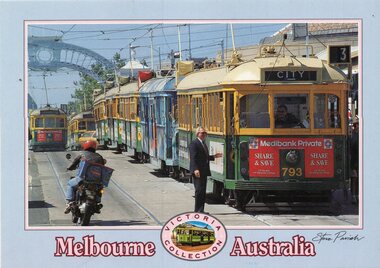
Postcard, Steve Parish Paddington Qld, Prince's Bridge, late 1980's
Colour postcard grey border, divided back - Steve Parish postcard of 7 trams on Prince's Bridge, with a blue arch in the background. The lead tram - W5 or SW5 793 showing route 3, followed by many trams. On the other track appears to be SW5 872, route 15. Both have Medibank Private adverts on the front. May have been at the time of an event, given that a Officer in a suit is talking to the driver. Back has space for name and address, stamp and a message and details of the postcard. Produced by Steve Parish Postcards. Card No. PC3029 and a historical note regarding trams on the back. Has "Melbourne Australia" along the bottom edge.trams, tramways, princes bridge, sw5 class, route 3, route 15, tram 793, tram 872? -
 Eltham District Historical Society Inc
Negative - Photograph, Tom Prior, Langlands Bridge, Eltham, c.1900
It is noted in the Reynolds Prior collection (Ivy Reynolds) as the first bridge in Eltham however given the current state of knowledge, this is considered unlikely and there is no other supporting source. John Hunter Langlands, owner of the farm known as ‘Ihurst’ on the west side of Diamond Creek to the south of John Wright Murray’s land, died in 1907. In 1909 his land was subdivided into 100 lots to become the ‘Glen Park Estate’. It is possible that the bidge may have crossed the Diamond Creek to Langland's land along the original alignment of Glen Park Road which used to run between present day Progress Road and Coleman Crescent. SEPP Source (c.1970): Mrs. E.R. Reynolds, Thompson Crescent, Research The Reynolds family were early settlers in Research. The Reynolds/ Prior collection of photographs were taken by Tom Prior, the maternal uncle of Ivy Reynolds, around 1900 and the 60 photos in the album give a fine overview of many of the landmarks of Research and Eltham over 100 years ago. lvy lived in the family home for many years at 106 Thompson Cres Research. Ivy's father, Ernst Richard Reynolds and grandfather, Richard Reynolds, lived at the same address. Ivy's father Richard worked for Mr. Trail on his property in Research. Reynolds Road is named after the family. Mr Tom Prior (wife Eva) worked at the Melbourne zoo. He was very innovative and made his own camera, using the black cloth hood to exclude the light. The photographs are a reminder of the rural nature of Research and Eltham and its rich heritage. This photo forms part of a collection of photographs gathered by the Shire of Eltham for their centenary project book,"Pioneers and Painters: 100 years of the Shire of Eltham" by Alan Marshall (1971). The collection of over 500 images is held in partnership between Eltham District Historical Society and Yarra Plenty Regional Library (Eltham Library) and is now formally known as the 'The Shire of Eltham Pioneers Photograph Collection.' It is significant in being the first community sourced collection representing the places and people of the Shire's first one hundred years.Digital image 4 x 5 inch B&W Neg B&W printsepp, shire of eltham pioneers photograph collection, eltham, langlands bridge, reynolds prior collection, bridge, john hunter langlands -
 Orbost & District Historical Society
black and white photographs, 1975
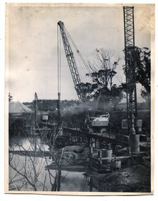
These are photographs of the construction of the current cement road bridge across the Snowy River at Orbost. Construction of the bridges commenced in January 1975, with an expectation to open the bridge across the Snowy River as soon as possible. Less than two years later, on 25 November 1976, the bridge across the Snowy River was opened to traffic, allowing the old bridge to be demolished. The remainder of the Orbost Bypass, both the floodplain crossings and the eastern section around the township itself, was declared ‘Princes Freeway’ and opened to traffic in December 1977. (ref http://mrv.ozroads.com.au)The opening of this Snowy River Bridge was an important development in the accessibility to the township of Orbost. These photographs record its construction.Two black / white photographs showing the construction of a road bridge across a river. 3257.1 shows piles being dropped beside the bridge, 3257.2 is of the early stages of construction of this bridge.snowy-river-bridge-orbost road-construction-orbost bridge-orbost -
 Flagstaff Hill Maritime Museum and Village
Craft - Ship Model, S.S. Casino
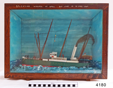
Ship model of coastal trader SS Casino in glass fronted case with stained wood frame. Ship has both steam and sail. Background of lighthouse on cliff, sea and sky. Ship painted green, 3 flags flying. Details (incorrect) of ship painted in white across top frame of case. The S.S. Casino was a passenger and freight steamer built in Dundee, Scotland, in 1882 for the Newcastle and Hunter River Steam Navigation Company of N.S.W. She weighed 425 tons gross with a length of 160.4 feet, beam of 24.1 feet and depth of 10.2 feet. She had saloon accommodation for 35 people, forecabin for 25 more people, and she carried 300 tons of cargo. While on her delivery journey on May 30th 1882 the S.S. Casino called in at the Port of Warrnambool for coal ., narrowly escaping going ashore in gale force winds due to the quick action of the pilot. At that time, still at anchor, she impressed the directors of the Belfast and Koroit Steam Navigation Company so much that they bought her immediately; she was ideal for trade in along the West Coast of Victoria. (Belfast is the original name for Port Fairy, South West Victoria. The Belfast and Koroit Steam Navigation Company was first managed by Messers. Saltau and Osburne and after the passing of Mr. Osburne, by produce merchants Messers H. Sautau and Sons, whose had a hay and corn store and shipping agency was on the corner of Liebig and Koroit Streets in Warrnambool. ) The S.S. Casino became “the most famous steamer to operate in Victorian waters along the West Coast” by author Jack Loney. Captain Boyd was her first Master, followed by Captain Chapman, who stayed with her 1890 until 1924. Captain W. Robertson followed for a short term, then Captain Middleton then took command 1925 - 1932. The S.S. Casino had several mishaps during her life. One was on 3rd January 1898 when she collided with the S.S. Flinders in Apollo Bay with minor damage. Another was on 24th October 1924 when she grounded on a reef at Point Hawdon near Grey River and most of her cargo (of Christmas goods) had to be dumped into the sea. Then in February 1929 she was ‘holed’ when she struck a submerged object as she entered Lady Bay, Warrnambool. On the morning of 10th July 1932, after attempting to berth at Apollo Bay jetty in heavy seas, Captain Middleton decided to take her out into the bay and wait until the seas abated. It was not realised that the anchor used to steady her as she manoeuvred to her berth had pierced her hull. She put about and headed for the beach but sank. Captain Middleton and nine others lost their lives; nine people were rescued including the two female passengers . Captain Middleton had been in charge of the S.S. Casino for seven years. He was the first ship’s Master to lose his life through shipwreck in the West Coast trade. In the years following the turn of the century the S.S. Casino remained the only regular trader with normal passenger accommodation along the West Coast. From 1882 she had made at least 2,500 voyages on the one run. Flagstaff Hill’s collection has a photograph of a portrait of Captain Chapman, , a ship model of the S.S. Casino that shows both forms of power under which she sailed, steam and sail. The ship is painted green and flies three flags. The inscription across the case of the ship model, incorrectly dated, tells the sad story of the wreck of the ship and the loss of lives on July 10th 1932 at Apollo Bay. A print in the Collection show S.S. Casino underway in heavy sea off Point Lonsdale, another two photographs show her at the Port of Warrnambool, leaving from the Breakwater in Lady Bay and another identifies the S.S. Casino as a ship from the Belfast and Koroit Steam Navigation Company. (Belfast is the original name for the township of Port Fairy). This ship model is significant because of its association with the coastal trader S.S. Casino 1882-1932 and its significance to trade along Victoria's West Coast in the late 19th and early 20th century. The wreck of the S.S. Casino is considered an important part of Victorian and Australian cultural heritage and as such has been declared and protected as an Historic Shipwreck under State and Commonwealth Law in the Commonwealth Historic Shipwrecks Act (1976). Ship model SS Casino in glass fronted case with stained wood frame. Ship has both steam and sail. Background of lighthouse on cliff, sea and sky. Ship painted green, 3 flags flying. Details of ship painted in white across top frame of case. NOTE: Correct details for shipwreck is 10 July 1932, at Apollo BayPainted in white on wood across top of case "SS CASINO WRECKED AT APOLL BAY JUNE 10 10 LIVES LOST".flagstaff hill, warrnambool, shipwrecked coast, flagstaff hill maritime museum, maritime museum, shipwreck coast, flagstaff hill maritime village, great ocean road, newcastle and hunter river steam navigation company, belfast and koroit steam navigation company, h. sautau and sons, s.s. casino, west coast trader s.s. casino, victorian coastal trader, captain boyd, captain w. robertson, captain chapman, captain middleton, apollo bay shipwreck, s.s. casino at lady bay warrnambool, ship model s.s. casino, saltau and osburne -
 Queenscliffe Maritime Museum
Functional object - Fishermans Cottage, Built in 1870/1880 for Thomas and Anna Ikin
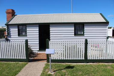
This low-lying northern-most tip of Queenscliff saw its physical origins in 1863 with allotments let to a burgeoning fishing community previously accommodated on the site of the current railway station and whose construction in 1879 necessitated eviction. Among this community, Chinese fishermen are thought to be of the first international settlers. The success of the fishermen’s settlement was due in part to commercial trading prospects the railway afforded and the size of catch available to those fishing in Bass Strait. Salmon, snapper and particularly barracouta led to the success of the local industry.Original Fishermans Cottage previously located at Swan Bay end of Bridge Street Queenscliff. Timber - Weatherboardfishermen's cottage, fishermen's flat, queenscliff -
 Otway Districts Historical Society
Book, Adventures with shipwrecks
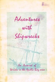
An account shipwrecks from 1880 to 1958 in the Apollo Bay area.Adventures with shipwrecks. An account of wrecks in the Apollo Bay area. J.K. Loney. 1st ed. Apollo Bay (Vic); J.K. Loney; nd. 20 p.; illus, map. Soft cover.222mm x apollo bay; j.k. loney; shipwrecks;, apollo bay; j.k. loney; shipwrecks; -
 Lakes Entrance Regional Historical Society (operating as Lakes Entrance History Centre & Museum)
Photograph, Caire, Nicholas John, 1905c
turning on a central axis to allow the passage of river vessels. Image shows machinery for operation and the bridge closed to river traffic. Latrobe Wharf on the left bank is seen through bridge. Sale VictoriaBlack and white photograph of the Latrobe Bridge. This was a swing bridge over the Latrobe Riverbridges, waterways, civil engineering, jetties -
 Eltham District Historical Society Inc
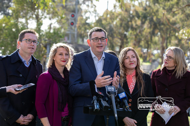
Photograph, Peter Pidgeon, Victorian Labor Government Press Release announcing planned upgrades to Hurstbridge line rail services and protection of historic Railway Trestle Bridge, Panther Place, Eltham, 1 August 2018, 1 Aug 2018
Announcement by Premier Daniel Andrews, Minister for Public Transport, Jacinta Allan and Member for Eltham, Vicki Ward mad alongside the Eltham Railway Trestle Bridge. MEDIA RELEASE "More Trains And Fewer Delays On The Hurstbridge Line" https://www.premier.vic.gov.au/wp-content/uploads/2018/08/180801-More-Trains-And-Fewer-Delays-On-The-Hurstbridge-Line-1.pdf Commuters on the Hurstbridge line will have more trains, more seats and fewer delays with a re-elected Andrews Labor Government to continue its massive upgrade of the Hurstbridge line. The Andrews Labor Government said it would deliver locals in Melbourne’s north-east more peak hour train services and less time stuck at boom gates, and we have. The first stage of the Hurstbridge Line Upgrade has been delivered – six months early and on budget. This includes the new Rosanna Station, duplicated track between Heidelberg and Rosanna and the removal of the dangerous level crossings at Alphington and Rosanna. There’s more to do and only Labor will deliver the next stage of the Hurstbridge Line Upgrade to give local commuters more train services and a more comfortable commute. The $530 million project will include a brand new train station at Greensborough and the duplication of three kilometres of track between Greensborough and Montmorency, and 1.5 kilometres of track between Diamond Creek and Wattle Glen to allow more train services during the morning peak. This will allow trains to run every six and a half minutes at Greensborough, every 10 minutes at Eltham and Montmorency, and every 20 minutes at Hurstbridge, Diamond Creek and Wattle Glen – as well as two extra Hurstbridge express services. Locals on the Labor Government’s new Mernda line will also get five extra train services during the morning peak, with a major upgrade of the Clifton Hill junction where the Mernda and Hurstbridge lines connect. Labor will also protect the Eltham Trestle Bridge – the last remaining timber bridge on Melbourne’s electric train network – which has local heritage protection and is an important part of the area’s character. The Liberals will leave this bridge to rot and demolish the nearby childcare centre and football club with their under-cooked and under-costed promise to upgrade the Hurstbridge line. Only Labor will protect this important piece of Melbourne’s history with planning work to be carried out for a long-term solution as part of the project. Stage two of the Hurstbridge Line Upgrade will create more than 950 jobs, with construction to start in 2020 and finish by 2022. Quotes attributable to Premier Daniel Andrews “We said we’d upgrade the Hurstbridge line and remove dangerous and congested level crossings at Rosanna and Alphington and we did – but there’s more to do.” “Only Labor will deliver the next stage of the Hurstbridge Line Upgrade with a new Greensborough Station and more trains, more often.” Quote attributable to Minister for Public Transport Jacinta Allan “The former Liberal Government promised new train lines but didn’t deliver a single kilometre of track – now they’re promising a half-baked upgrade of the Hurstbridge line with rubbery figures that don’t add up.” Quote attributable to Member for Eltham Vicki Ward “As a fifteen year old hopping on Red Rattlers at Eltham I wanted to do something to make the Hurstbridge line better. It’s taken me a few decades but finally our line will offer the frequency of services that are expected and needed in a 21st century city.”Born digital image (qty 27)jacinta allan, minister for public transport, panther place, premier daniel andrews, press announcement, railway line construction, trestle bridge, vicki ward mp for eltham, victorian parliament -
 Kew Historical Society Inc
Photograph - Second Johnston Street Bridge in Flood, 1934
Original, small black and white print photograph of crowds lining the Johnston Street Bridge watching the flood waters below. The annotation on the reverse clarifies that Kew is in the distance.Annotated on reverse: "Gift of G.S. Beard / 2nd bridge / Johnston St. Studly Park Rd. Bridge looking towards Kew / 1st bridge 1858–1876, 2nd bridge built (bad bend), 1876–1958, 3rd bridge 1958, lined up Johnston St and Studley Park Rd."johnston street bridge, bridges - yarra river -- kew (vic.), flood -- 1934 -
 Ballarat Tramway Museum
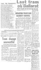
Newspaper, The Courier Ballarat, "Tram Shelter for Christmas Crib", "SEC replies to Lake tram proposal", "A Farewell tram ride", "Keep buses out of Bridge St", "Bus stops blamed for drop in business", "Complaint of parking loss through bus stops", "last journey for 39", "Last tram to start in filmed about Ballarat" "The end for tram 31?", "Destination Hamilton", late 1971
Yields information about the closure of the SEC operated Ballarat system - presented in an unorganised manner and without newspaper dates.Set of 8 foolscap size photocopies on heat sensitive paper of various newspaper cuttings compiled - many duplicated - about the closure of the Ballarat Tram system, mainly from The Courier, Sept to Dec. 1971. Principal headlines are: "Tram Shelter for Christmas Crib", "SEC replies to Lake tram proposal", "A Farewell tram ride", "Keep buses out of Bridge St", "Bus stops blamed for drop in business", "Complaint of parking loss through bus stops", "last journey for 39", "Last tram to start in film about Ballarat" "The end for tram 31?" "Destination Hamilton" - see item 9520 for the original cutting See also Reg item 3165 and 3161 for similar presentations of cuttings. sec, ballarat, disposal, tramcars, btps, shelters, shelters, buses, closure, bridge st, hamilton, shelters -
 Glenelg Shire Council Cultural Collection
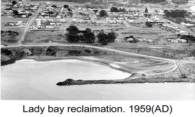
Photograph - Photograph - Lady Bay reclamation, c. 1960
Port of Portland Authority archivesFront: (no inscriptions) Back: Lady Bay Reclamation 1959 (black pen, upper left)port of portland archives, lady bay, reclamation -
Lakes Entrance Regional Historical Society (operating as Lakes Entrance History Centre & Museum)
Postcard, H D Bulmer, 1908 c
Also a second black and white photograph of Swan Reach Tambo River 05378.1Sepia toned postcard showing the SS Burrabogie about to go through the open left bridge over the Tambo River at Swan Reach VictoriaSwan Reach Bridge Tambo Riverguesthouses, recreation -
 Hume City Civic Collection
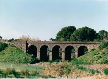
Photograph, late 1980s
The five span masonry arch bridge over Blind Creek was one of the major constructions on the Melbourne to Echuca Railway. It was one of the first masonry rail bridges built in Victoria. Construction began in 1859 when the railway was extended from Sunbury and was designed by G C Darbyshire.A coloured photograph of the 5 arched bluestone rail bridge showing the grassy embankments on each side of the bridge and the creek flat at the base of the bridge. Some tree tops are visible on the other side of the bridge.bridges, transport, rail transport, darbyshire, g. c., blind creek, v line, george evans collection -
 Peterborough History Group
Article - Saving a link with history
Further publicity pertaining to the historical links with the old Peterborough bridge and its retention, upon construction of a new bridge.Significant community support for retention of the old bridge.Full page article about the construction of the original bridge at Peterborough and the drive to retain it after a replacement bridge is built.Handwritten in ink "Warrnambool Standare Dec 19th 1985peterborough, peterborough old bridge, curdies river bridge, warrnambool standard -
 Halls Gap & Grampians Historical Society
Photograph - Photocopy, C 1930s
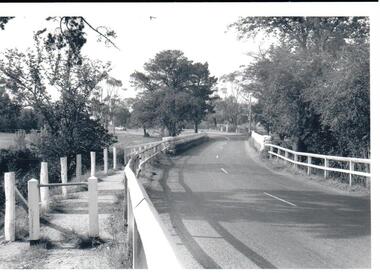
The third Delley's Bridge, a timber and concrete structure with a curved deck, built in 1940. It was situated slightly upstream from the previous bridge. After nearly 50 years of its use, wear and tear necessitated a fourth bridge to be erected in 2001.The picture shows a curving bridge with a wood and wire railing. An unsurfaced road crosses the bridge and the area is surrounded by trees.structures, tents -
 Whitehorse Historical Society Inc.
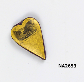
Souvenir - Heart shaped souvenir, 1870 - 1890
Heart shaped wood and velveteen souvenir. May have hung from a ribbon. Printed with a scenic view of river and high cliffs either side and a suspension bridge with figures in foreground.View from suspension bridgedomestic items, ornaments / decorative -
 Kew Historical Society Inc
Postcard - Zig-Zag Bridge
Sepia postcard of the Zig-Zag Bridge at Kew. The bridge was constructed in the 1870s to link the Yarra Bend Asylum and Kew Asylum. Initially it transported bluestone from the west side of the Yarra to the east during the construction of the Kew Asylum.Reverse: "Old Tramway Bridge / erected early 1850s / Zig Zag Bridge below mental grounds / washed away in flood / linked the mental asylums / donated by G.L. Beard"bridges - yarra river -- kew (vic.), zig-zag bridge -
 Hume City Civic Collection
Photograph
In the 1970s the bluestone bridge over Jackson's Creek ceased to be used and a wider bridge was constructed to its north. The curved approach to the bridge was taken out of the road and the old approach area was redeveloped and is now Apex Park.A black and white photograph of the old stone bridge over Jackson's Creek in Macedon Street. A utility is in the distance approaching the bridge.macedon street, jackson's creek, bridges, transport, apex park, sunbury, jackson's creek bridge, george evans collection -
 Phillip Island and District Historical Society Inc.
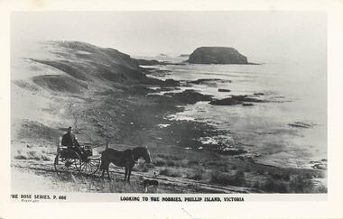
Photograph - Post Card, 1910
Donated by N. G. Hunt, Baxter, VictoriaBlack & White Postcard taken from Cat Bay looking towards The Nobbies. Man in Jinker with a sheepdog in foreground."The Rose Series, P. 666" "Looking to The Nobbies, Phillip Island, Victoria" On Back: "Cat Bay from Ventnor 1910"the nobbies phillip island, cat bay, phillip island, n g hunt -
 The Beechworth Burke Museum Research Collection
Card (Series) - Index Card, George Tibbits, 9 Bridge Street, Beechworth, 1976
George Tibbits, University of Melbourne. Faculty of Architecture, Building and Town & Regional PlanningIndex system that support the research for Beechworth : historical reconstruction / [by] George Tibbits ... [et al]Arranged by street names of BeechworthEach index card includes: street name and number of property, image of property, allotment and section number, property owners and dates of ownership, description of the property according to rate records, property floor plan with dimensions.beechworth, george tibbitsbeechworth, george tibbits -
Stawell Historical Society Inc
Book - History, Marten A Syme, Shipping Arrivals and Departures V.I. 1798 -1845 Victorian Ports
Immigrant Arrivals at Victorian ports between 1798-1845Hard Back Dust Jacket. White Print. Print: View of Portland Bay By George Jackson in ColourA Roebuck Book Shipping Arrivals and Departures Victorian Ports {View of Portland Bay} Volume 1 1798-1845 Marten A. Syme -
 Hume City Civic Collection
Photograph
A black and white photograph of a bluestone arched bridge over Jackson Creek in Macedon Street. Taken at Easter 1934.on back: written in pen; Bridge @ Sunbury / Easter 1934cullinan, uraina, eileen, sunbury, jackson creek, macedon street, bulla, bridges, bluestone bridge, 1930s, george evans collection