Showing 19894 items
matching east-malvern
-
 Ballarat Tramway Museum
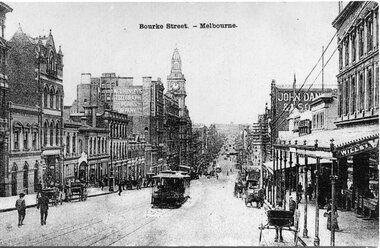
Postcard, Bourke St. Melbourne, looking east
Black & white postcard of Bourke St. Melbourne, looking east, taken from about Queen St. Has cable trams climbing hill and other horse drawn vehicles. Buildings in view are GPO, 'W.T.Henleys Telegraph Works Company Ltd,', 'John Dansk & Son'. Date unknown. On rear area areas set aside for address, correspondence and stamp. Postcard made in Belgium.trams, tramways, melbourne, bourke st., cable trams, tram 14 -
 Kew Historical Society Inc
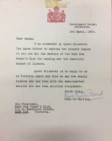
Document, Letter to the President of the East Kew Women's Club from the Lady in Waiting to Queen Elizabeth The Queen Mother, 1958
The Queen Mother was undertaking a Royal Tour to Australia in 1958. The letter was in response to a basket of flowers that the members of the Club had sent. Letter sent to the President of the East Kew Women's Club from Olivia Mulholland, Lady-in-Waiting to Queen Elizabeth the Queen Mother, thanking the members for a basket of flowers that they had sent to the Queen Mother. The letter is accompanied by a photograph of the flowers (1974.0017b). The letter, on Government House letterhead is dated 3rd March 1958. The item includes the letter and the envelope. [The photograph of the flowers can be viewed as item 1973.0017b].east kew women's club, quuen elizabeth the queen mother, 1958 royal tour (victoria) -
 Ringwood and District Historical Society
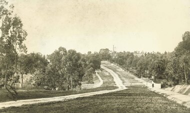
Photograph, Maroondah Highway East, Ringwood- 1900. Sandy Creek Bridge, Maroondah Hwy
3 photographs ( 2 large black and white, 1 small sepia)Written on all copies: "New Sandy Creek Bridge". Typed below large photograph: "Maroondah Highway Ringwood looking east. To right of bridge is now Ringwood Lake. Mount Dandenong Road turnoff to right at top of rise with antimony mine in background - 1900". -
 Bendigo Art Gallery
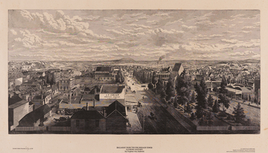
Work on paper, Eugene VON GUERARD, Ballarat from the Fire Brigade Tower (Looking East) 1870, 1870
c.l; Limited Edition number PROOF of 150, c; Ballarat from the Fire Brigade Tower/ (Looking East) 1870/ by Eugene Von Guerard, c.r;; An engraving printed from/Eugene Von Guerards original woodblock/now in the possession of the Ballarat Historical Societywork on paper, print, printmaker, printmaking, australian artist, ballarat, wood engraving, city, town, regional victoria, goldfields -
 Orbost & District Historical Society
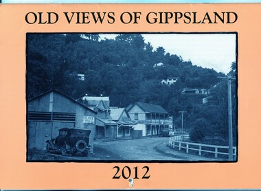
calendar, Old Views of Gippsland 2012, 2011
This item is one of a series of calendars published annually by East Gippsland Historical Society.This item is a useful reference tool.A 2012 stapled calendar, titled "Old Views of Gippsland". On the light tan coloured front is a black/white photograph of Main Road Walhalla looking south towards the Star Hotel C / 1951. It contains early photographs of East Gippsland, one for each month. There is a hole for hanging.The title is at the top and the year at the bottom in black print. -
 Ringwood and District Historical Society
Banners, East Ringwood Primary School sports Banners 1964-1979, 1964-1978
Collection from East Ringwood Primary School of championship banners, crossball champions in 1969, tunnel ball champions 1967 and 1969, basketball champions from 1964-1969, runners-up in football and netball 1978 and 1979. (No names check with history notes on school)One large canvas banner - E.R.S.S. No.4180; 24 various sized banners for sporting achievements in crossball (7), basketball (6), tunnel ball (8), football (1), netball (1), swimming (1) with various coloured rods at the top and gold fringes along the bottom. -
 Ballarat Heritage Services
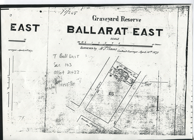
Digital photograph, Graveyard Reserve, Ballarat East
Ballarat East, Section 103, Allotment 21 & 22, Peake and Tress Streets, Mount Pleasant. Surveyed by W. S. Reeves Contract Surveyor April 14th, 1871. Also shows allotments of T. Williams and F. Macalpin, as well as the Powder Magazine Reserve.Plan of the Graveyard Reserve and Mount Pleasant Powder Magazine.mount pleasant, w.s. reeves, plan, powder magazine, t. williams, f. macalpin -
 Stawell Historical Society Inc
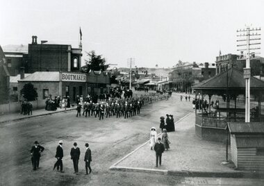
Photograph, Bandsmen leading Senior and Junior Cadets in Main Street Stawell looking East from Memorial Area 1908
Parade of Bandsmen leading Senior and Junior Cadets in Main Street looking East from Memorial Area 1908. Boot makers shop between Town hall and Anglican Church on left Town Hall Hotel and shops on right with band rotunda to right of photo.stawell band pavillion boer war streetscape -
 Kew Historical Society Inc
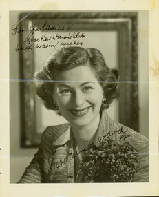
Photograph - Geraldine Ward, 1960
The East Kew Women’s Club was formed on 20 July 1945 as an experiment amongst local women, who felt that there was a need for some organised group to give full scope to their various interests and hobbies. In the beginning, they met at the house of their founder, Mrs Eric Thake, 48 Harp Road, East Kew, but the growth and interest was so rapid that it was soon necessary to find a larger meeting place, so the group moved to the Harrier’s Pavilion in Victoria Park, Kew. At the fifth meeting of the group, a committee was formed, and a constitution adopted on 4 December 1945.The Club was aimed to be non-political, non-sectarian and open to women from any locality. The Club’s motto was “To Help others, Improve Ourselves, and Foster the Community Spirit”. The first twenty years of the Club was recorded in a small, nine-page publication “East Kew Women’s Club : Twenty Years 20-7-1945 - 30-7-1965”.Portrait photograph of Geraldine Ward, signed, dated and addressed to the Ladies of the East Kew Women's Club.Obverse: [Signed in ink] For the ladies of the East Kew Women's Club with warm wishes, Geraldine Ward 1960." [Reverse annotated] Presented to Society with Minute Books from East Kew Women's Club. / Signed Geraldine Ward across photo / KH-217 / {Stamped] Hand Hasenpflug Illustrative Photography, 62 Swanston Street, Melbourne, Phone CENT 2187.clubs -- kew east (vic.), east kew women's club, glenda ward -
 Ringwood and District Historical Society
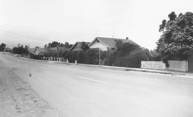
Photograph, Soldiers Homes' Bedford Rd. looking east from outside shops, Illoura Ave. 1973"
Typed below photograph, "Bedford Rd. looking uphill from near corner of Illoura Ave. 1974" Date of 1973 written on backing sheet. Catalogue card reads, "'Soldiers Homes' Bedford Rd. looking east from outside shops, Illoura Ave. 1973". -
 Orbost & District Historical Society
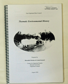
book, Thematic Environmental History, 2001
This booklet was prepared for the East Gippsland Shire Council in August 2001.A Thematic Environmental History identifies how key patterns of development have influenced the culture of the area and the natural and built environment. The document is not a social history but usually provides the context for future heritage studies and assessments and would provide input to the preparation of a Heritage Action Plan. This booklet prepared for the East Gippsland Shire councilA spiral bound book of 75 pp, titled Thematic Environmental History, prepared by Meredith Fletcher and Linda Kennett for the Centre for Gippsland Studies, Monash University, Gippsland Campus. On the front cover is a black and white drawing of a paddle steamer towing a barge along a river. It contains information on the discovery, settlement and land usage of East Gippsland as well as the development of transport, communication and cultural institutions. Copywright held by East Gippsland Shire Council and Department of Infrastructureenvironmental-study-east-gippsland -
 Ringwood and District Historical Society
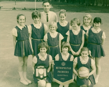
Photograph, Girls' basketball (netball) team of Ringwood East Primary School Metropolitan Premiers 1967, 1967
Note - Rhonda Clarke was reported as being related to Olympic runner Ron Clarke.Photograph of girls' basketball (netball) team of Ringwood East Primary School Metropolitan Premiers 1967. +Additional Keywords: Deany, John - teacher standing at rear, with back row L-R (standing) and front row L-R (kneeling): / Holmberg, Peta / Sanbrook, Gillian / Benson, Peta / Parker, Lyn / Harmen, Janice / White, Anne / French, Cheryl / Clarke, Rhonda / Cleary, Jenny / Rattray, Peta -
 Ballarat Tramway Museum
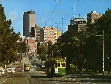
Postcard, Murfett Pty Ltd, Wellington Parade, East Melbourne
Colour postcard of Wellington Parade, East Melbourne with Melbourne skyline in background and Fitzroy Gardens in background. Would appear works for the underground are in progress. Has W2 509, outbound on route 29 to 'Kew Depot' and a tram (wide body car) in bound on route 74. Has on rear caption, "National View" by Murfett Pty Ltd. Australia, place for address and stamp. Taken early 70's.trams, tramways, melbourne, wellington parade, postcards, tram 484, tram 229, tram 364 -
 Melbourne Tram Museum
Document - Report, Parliament of Victoria, "Report from The Parliamentary Public Works Committee on the East Burwood Tramway Inquiry", Jul. 1976
Report - foolscap duplicated copy of a report - 15 pages stapled in top left hand corner titled "Report from The Parliamentary Public Works Committee on the East Burwood Tramway Inquiry", dated 7/7/1976. Provides details to the background of the recommendation to construct the tramline, including costs, summary of evidence, alternatives and proposed services. See Reg Item 689 for other documents associated with this inquiry.trams, tramways, east burwood, victorian government, parliament, enquiries -
 Melbourne Tram Museum
Pamphlet, The Met, "North East Travel Come Aboard - Bundoora - RMIT Route 86", Oct. 1995
Folded full colour printed on glossy paper pamphlet titled "North East Travel Come Aboard - Bundoora - RMIT Route 86" for the opening of the Bundoora tramway extension 12 October 1995, with a complimentary ticket. Gives details of the extension to the RMIT Campus at Bundoora, associated bus routes and the companies operating them, RMIT launch celebrations, and a map. Published by The Met, has logos. Two copies held.trams, tramways, bundoora, route 86, opening, rmit -
 Melbourne Tram Museum
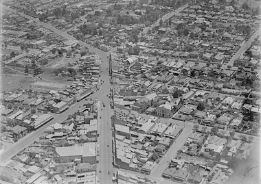
Photograph - Digital Image, Kevin O'Reilly, Kew Junction from the north east, towards the city, c1930's
Image from CD (Compact Diskette for use in computers) - see Reg Item 135. Image titled "Kew Junction' on CD, of looking Kew Junction from the north east, towards the city, shows the Kew railway station precinct. Has a inbound W class tram picking up passengers at the Kew Post Office. A summer day. Possibly late 1920's, early 1930's.trams, tramways, kew, kew junction, kew post office, high st -
 Melbourne Tram Museum
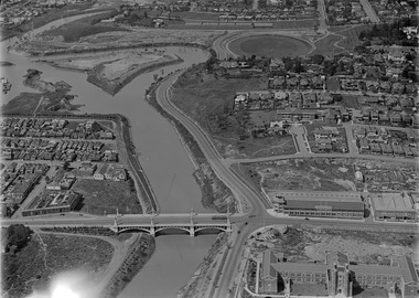
Photograph - Digital Image, Kevin O'Reilly, Richmond looking east along the Yarra River, c1930's
Image from CD (Compact Diskette for use in computers) - see Reg Item 135. Image titled "Richmond 7" on CD, of looking east along the Yarra River where the Church St Bridge Richmond crosses the River, Alexandra Ave. Has an ex HTT Maximum Traction tram crossing the bridge. Shows now Herring Island after the Yarra River was cut through to form the island.trams, tramways, richmond, chapel st, church st, yarra river -
 Orbost & District Historical Society
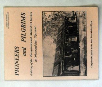
books, Pioneers and Pilgrims, 1986
Rev Peter Gador-Whyte's first UCA Parish was at Orbost in East Gippsland.This is a local history book useful for research and written by a local.Two copies of a 76 pp book titled Pioneers and Pilgrims a history of the Presbyterian and Methodist Churches in Orbost and East Gippsland. The front cover is buff coloured and has a b/w photograph of a group of people standing outside a hut with a bark roof. On the right hand side is a man on a horse. The book was compiled and edited by the Revd Peter Gador-Whyte.2178.2 - Ruth Leggechurch-history presbyterian-methodist-orbost -
 Orbost & District Historical Society
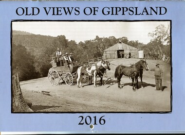
calendar, Old Views of Gippsland 2016, 2015
This item is one of a series of calendars compiled and published by East Gippsland Historical Society.This item is a useful reference toolA 2016 stapled calendar, titled "Old Views of Gippsland". On the light blue coloured front is a black/white photograph of Tongio Gap, Omeo, showing Mitchell's coach which ran from Bairnsdale to Omeo. The calendar contains early photographs of East Gippsland, one for each month. There is a hole for hanging. The title is at the top and the year at the bottom in black print. calendar-old-views-gippsland photographs-histporic-gippsland -
 Stawell Historical Society Inc
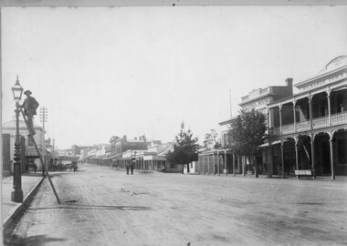
Photograph, Main Street Stawell from front of Town Hall looking East with Mr Richard Miller lighting the gas light on left of photo
Main Street from front of Town Hall looking East. Mr Richard Miller on ladder to the gas light on left of photo. After 1901 Acetylene Gas lamps were installed in Main Street. Benzene lamps were used for some years. A lamplighter was employed from 1913.B/W Photo With Mr Richard Miller lighting the light on the left and the Town Hall on the Rightstawell streetscape -
 Ringwood and District Historical Society
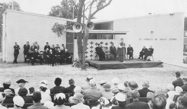
Photograph, Opening of St. Francis de Sales School, Patterson Street, Ringwood East - November 1958. The Roman Catholic Church-School was opened by Archbishop J.D. Simmonds, with the Mayor of Ringwood (Cr. R.O. Spencer), the Mayoress, and Crs. P. Vergers, R. Horman, I. McLeod and D. Baxter also present
Printed below photograph, "Opening St. Francis de Salle - 1958". Written on backing sheet, "Archbishop Simmonds opens East Ringwood School, St. Frances de Salle. See 'Mail' 27th Nov. 1958 for full report and 4th Dec. 'Mail' for names in photo." -
 Ringwood and District Historical Society
Photograph, Maroondah Highway Central, Ringwood. Rear of shops in Maroondah Hwy east of Adelaide Street- 1963
Black and white photograph (3 copies- 2 large, 1 small)Typed below large photograph: "Rear of shops in Maroondah Highway. Taken from Adelaide St. near Warrandyte Rd. 1963". Written on back of another copy: "Rear of shops in Maroondah Highway east of Adelaide Street. Shed on right is in Adelaide St opposite 'Mail' office." -
 Ringwood and District Historical Society
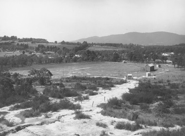
Photograph, East Ringwood oval c.1928
Typed below photograph, "View of East Ringwood oval from present site of Civic Centre. Mt. Dandenong Rd. on right - 1935". Catalogue card reads, "Suggest this photo is taken early 1920s.... E.R.F.C. was established approx. 1928. Prior to this the Ringwood F.C. played on the oval". -
 Ringwood and District Historical Society
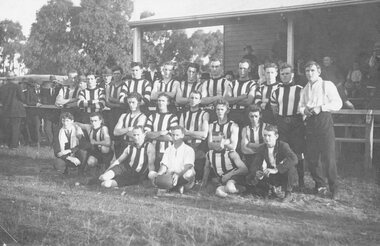
Photograph, Ringwood Football Team at East Ringwood Oval, circa 1923
Typed below photograph, "Ringwood Football Team at East Ringwood Oval, circa 1923". Catalogue card reads, "1924 Football Team. Premiers - 19 winds straight at East Ringwood Oval. Back Row: L-R. W. Kennett, G. Dempster, M. Kiker, M. Sellers, H. Nelson, E. Aumann, B. Bowen, A. Cooper, F. Pickett (Trainer). Second Row: V. Crompton (Trainer), C. Pendlebury, J. Lawler, W. Rhodes, W. Allan (Capt.), B. Caldwell. Front Row: B. Webster, T. Tovey (Umpire), F. Corft, J. Pratt". -
 Stawell Historical Society Inc
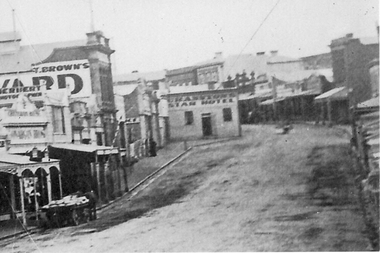
Photograph, Enlargement of Catalogue number 0541 of Main Street looking East featuring the Star Hotel, 1890's
Enlargement of right hand side of photo 0541. Top end of Main St. looking East towards Big Hill. From left Herbert Photographic, T Brown, Star Hotel on bend jutting out into middle of road. Mechanics Institute in background. Two Horse wagon in street on left.stawell businesses streetscape -
 Stawell Historical Society Inc
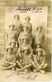
Photograph, Stawell Soldiers World War 1 In the Middle East -- named
Stawell Soldiers World War 1 In Middle East campaign uniform. (Back Row) A Patten. C Crosbie. G Potter. Cpl E Thomas. E Potter. Cpl G Taylor. Sgt F Uren. S Nimmo. (Front Row) L Bush. A Bailey. E Newton. stawell ww1 -
 St Kilda Historical Society
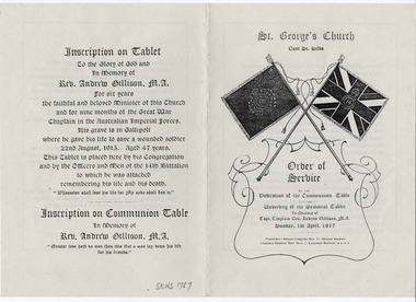
Ephemera - Pamphlet, The Colours (at St George's Church, East St Kilda), c1994
Pamphlet explaining the memorial at St George's Church in East St Kilda to former minister Rev Andrew Gillison, MA, who served as Chaplain for overseas service in World War I and died at Gallipoli in 1915 while attempting to rescue a wounded soldier. The memorial was erected at the request of the 14th Battalion.White paper printed in black on both sides and foldedworld war i, 14th battalion aif, 2/14th army battalion, rev andrew gillison, st george's east st kilda uniting church -
 Orbost & District Historical Society
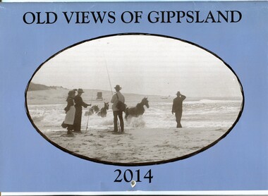
calendar, Old Views of Gippsland 2014, 2013
This is one of a series of calendars published annually by East Gippsland Historical Society.This item is a useful reference tool.A 2014 stapled calendar, titled "Old Views of Gippsland". On the blue coloured front is a black/white photograph of carriage horses being crossed through a lake entrance presumed to be Lake Tyers around the turn of the century C 1900 . It contains early photographs of East Gippsland, one for each month. There is a hole for hanging. The title is at the top and the year at the bottom in black print. -
 Kew Historical Society Inc
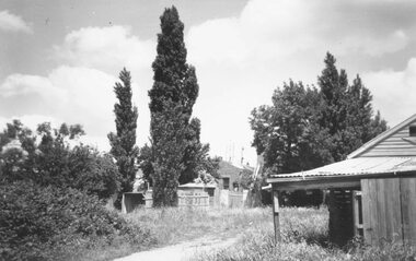
Photograph - Flooding of the Yarra Valley at Kew East, 1974
Flooding of the Yarra Valley, including that section of the Yarra bordering Kew and Kew East in the north and west of the municipality, was a regular occurrence. Extreme flood events of the Yarra River are recorded to have occurred in 1891, 1901, 1916, 1923 and 1934. The Municipality of Kew's response to these floods was to enact planning decisions restricting residential development in flood prone areas following the floods of 1916, 1921 and 1934. While floods continued after the development of the Upper Yarra Reservoir (construction 1948-57), the regularity and extent of these inundations diminished. During the nineteenth century, the land abutting the south side of the Yarra in Kew was devoted to dairy farming. In the twentieth century, before and after the construction of the Eastern Freeway, much of this low-lying area was used as golf courses and public parks.Late example of the capacity of the Yarra Valley at Kew to flood, even though drainage works and the Upper Yarra Reservoir had reduced their regularity.Original black and white print photograph of the low-lying land at East Kew under floodwater on 16 May 1974. The photograph is of Hyde Park looking north-east.Annotation verso: "Hyde Park looking nth-east / Flood Level / 16 May 1974 11.15am / R.L. 46.61"floods, yarra river, hyde park -
 Melbourne Tram Museum
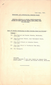
Document - List, Melbourne & Metropolitan Tramways Board (MMTB), "Official opening of Bourke Street - Northcote Routes at East Preston Depot 24th June 1955 at 3.00pm", 23/06/1955 12:00:00 AM
List - 7 foolscap sheets, duplicated, stapled in top left hand corner, titled "Official opening of Bourke Street - Northcote Routes at East Preston Depot 24th June 1955 at 3.00pm", listing the guests and the tram departure times along the route and those travelling on their own transport. Lists some 240 people overall. Lists their position or body representing for about half of the people. Dated 23/6/1955trams, tramways, east preston, bourke st, opening, new tramway