Showing 110305 items matching "roads"
-
 Marysville & District Historical Society
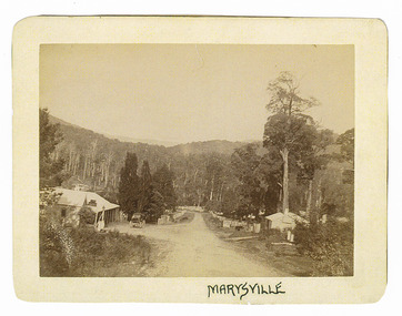
Photograph (Item) - Black and white photograph, Marysville, c1900
An early black and white photograph of the main road in Marysville in Victoria showing the Keppels Australian Hotel.An early black and white photograph of the main road in Marysville in Victoria showing the Keppels Australian Hotel which was built and opened by the Keppel Family in 1865. The Keppels Australian Hotel was the first hotel to be opened in Marysville. The Keppel Family were among Marysville's earliest pioneering families.ARMSTRONG COLLECTION 42 STATION STREET/ SANDRINGHAM 3191/ TEL. (03) 9521 5442/ IAN M.L. ARMSTRONG OAMaustralian hotel, marysville, keppel family, maurice john keppel, keppels australian hotel, keppels hotel, victoria -
 Mt Dandenong & District Historical Society Inc.
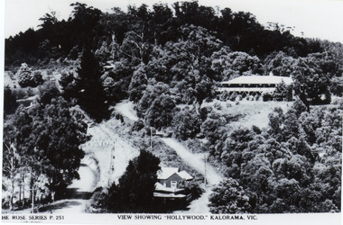
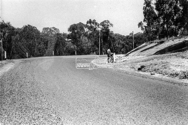
Photograph, View Showing 'Hollywood' Kalorama, Vic
Copy of Rose Series postcard #251 showing 'Mountjoy' named as 'Hollywood'. Mount Dandenong and Ridge Roads are visible at the FiveWays intersection along with the TeaRoom/Post Office. c1940Black and white photograph of a bushed setting with a building centre front and another, larger building up hill on RHS. Two unmade roads are visible with fences and telephone/power poles.The ROSE SERIES P. 251 VIEW SHOWING "HOLLYWOOD". KALORAMA, VIC.rose series, fiveways, guest house, mt dandenong road, ridge road, post office, hollywood, tea rooms, mountjoy -
 Hume City Civic Collection
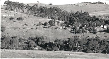
Photograph, 1980s
This photograph was taken from the intersection of Loemans and Sunbury Roads. It overlooks the site of the former Bula Primary School and the hillside where stones were laid and painted to form the words "Bulla". The lettering was possible a project carried out by the pupils at the school.A black and white photograph of a panoramic view overlooking the former Bulla Primary School. The photograph has been taken from the intersection of Loemans and Sunbury Roads.bulla primary school, bulla township, george evans collection -
 Eltham District Historical Society Inc
Photograph, Main Road, Panton Hill
Two colour photographs of Main Road Panton Hill showing roundabout at Church Road/Roger Road intersectionmain road, st andrews road, kangaroo ground/st andrews road, church road, roger road, roundabouts, panton hill -
 Whitehorse Historical Society Inc.
Map, Deep Creek Road, Mitcham, c1975
Enlargement of aerial photograph of area bounded by Dalmar Road, Cray Road, Glenvale Road and Maroondah Highway, MitchamEnlargement of aerial photograph of area bounded by Dalmar Road, Cray Road, Glenvale Road and Maroondah Highway, MitchamEnlargement of aerial photograph of area bounded by Dalmar Road, Cray Road, Glenvale Road and Maroondah Highway, Mitchamcray road, donvale, glenvale road, donvale, maroondah highway, mitcham, dalmor road, mitcham, deep creek road, mitcham, aerial photographs -
 Whitehorse Historical Society Inc.
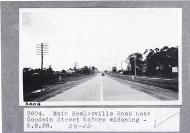
Photograph, Main Healesville Road, 5-9.1938
Whitehorse Road ( known as Main Healesville Road) near Goodwin Street, Blackburn in 1938. A two lane road.whitehorse road, main healesville road, goodwin street blackburn, blackburn -
 Whitehorse Historical Society Inc.
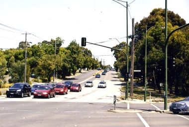
Photograph, Blackburn Road/Canterbury Road, Blackburn South, 2012
See NP4006Coloured photograph of the Blackburn Road and Canterbury Road intersection. Cars heading east on Canterbury Road towards Vermont.blackburn road, blackburn south, canterbury road -
 Whitehorse Historical Society Inc.
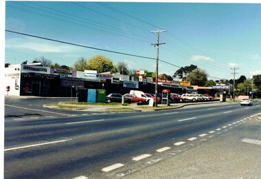
Photograph, Shopping Centre Forest Hill
Coloured photograph of the small shopping centre in Springvale Road between Parkmore Road and Jolimont Road Forest Hillshopping centre, springvale road forest hill, shopping centres -
Lakes Entrance Historical Society
Book, Road Design Manual, 1985
Road design manual for rural and urban roads other than freeways giving all aspects of road construction.road construction and maintenance -
 Eltham District Historical Society Inc
Photograph - Black and White Print, Unidentified road, Eltham district, c. Sep. 1966
... Roads ...On the left is an advertising sign for a housing development lots for auction sale, 20 acre lotsBlack and white photographic printOriginally located in a Filmpro King Size Prints processing envelope $3.01 Shire of Eltham 9/9/66 and noted as Calrossie Ave area and crossed out Eltham-Yarra Glen Road, Bridge Street to Elsa Court existing conditions mid 1967auction sale, housing estate, infrastructure, real estate agent, roads, sign, unidentified -
 Eltham District Historical Society Inc
Photograph - Black and White Print, Unidentified road, Eltham district, c. Sep. 1966
... Roads ...A postal employee (Postie) of the Post Master General (PMG) is delivering mail by bicycleBlack and white photographic printOriginally located in a Filmpro King Size Prints processing envelope $3.01 Shire of Eltham 9/9/66 and noted as Calrossie Ave area and crossed out Eltham-Yarra Glen Road, Bridge Street to Elsa Court existing conditions mid 1967infrastructure, roads, unidentified, australia post, post master general, postie, bicycle -
 Kew Historical Society Inc
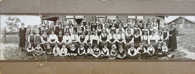
Photograph - Woodbury Ladies’ College, 1919
Woodbury College is an indirect predecessor of Preshil School in Kew. Woodbury College was founded in Glenferrie Road by a Miss Harcourt, former principal of Sydenham College, Moonee Ponds. Miss Harcourt maintained the school until the goodwill was purchased in 1908 by Miss LJ Macey, who had previously operated Lillsden Ladies' College in Edgevale Road, between c.1891 and c.1903. The first school was in a rented building on the south side of Cotham Road between Atkins and Davis Streets. In 1910, a new school building was built on the corner of Uvadale Grove and Cotham Road [the building is still extant as of 2020]. Woodbury College was operated by Miss LJ and Miss HJ Macey until 1920. In 1921, the school amalgamated with the newly formed St Andrew's College, Mont Victor Road, Kew (Vic) under the leadership of Rev JT Lawton [who had previously been principal of St Andrew's School of the 'Pathfinder' in South Yarra]. Miss Macey was for a period the Headmistress of the amalgamated school. Another teacher at the school was Miss Margaret JR Lyttle, who in 1931, left St Andrew's to form the Preshil School.A rare panoramic photograph of Woodbury College in Kew, Victoria. The photograph is part of a large collection of original manuscripts and ephemera relating to the school.Panoramic photograph of the students and teachers of Woodbury College, Cotham Road (Kew). Students identified in the photograph include: Back Row, 5th from left Betty Paton; 4th from right - Jean Strickey (sic).Annotation to reverse: "Woodbury College (Miss L.J. Massey) established Cotham Rd Kew. Est. at this venue 1908. Later joined by Rev. J.T. Lawton & formed a school in Mount Victor Rd Kew St Andrew’s College in 1921.’ woodbury college, cotham road (kew), education, schools, kew, l.j. massey, j.t. lawton, st andrew's college -
Port Melbourne Historical & Preservation Society
Photograph - Garrett Gerald TAAFE outside his home, c.1925
Garrett Gerald TAAFE (nicknamed 'Son'), trained, drove and rode Trotters and Pacers. The TAAFE family included his brother, Nicolas 'Nick' TAAFE, his wife Martha TAAFE nee GILMORE, her sister, Ellen 'Nell' VALE and Mary Genevieve VALE, Bridget BENNETT nee TAAFE, Aileen CAMPBELL nee TAAFE. Gerald died in 1935 aged 53 and his wife, Martha died in 1974 aged 92. They lived at 34 Williamstown Road, Port Melbourne.Digital photograph of Garrett Gerald 'Son" TAAFE with a horse outside his home at 34 Williamstown Road.martha taffe nee gilmore, mary genevieve vale, bridget bennett nee taafe, aileen campbell nee taafe, ellen 'nell' vale, garrett gerald taafe -
 Port Melbourne Historical & Preservation Society
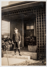
Photograph - Robert Cornelius Watters in front of Williamstown Road home c 1935
The Watters family moved from Albert Park to Garden City Port Melbourne circa 1934 buying a Bank House at 128 Williamstown Road (later renumbered to 400). The family consisted of Bob Watters senior and his wife Ellen (nee Oakley), children Patsy (b 1920), Bob Junior (b 1922) and Norma (b1924). The children attended Albert Park Primary, Middle Park Central School and then MacRobertson Girls High School and Melbourne Boys High School.Robert (Bob) Cornelius Watters in front of Williamstown Road home in Melbourne High School uniform 1935bob watters junior, robert cornelius watters, education - secondary schools -
 Ringwood and District Historical Society
Flyer, Executor's Auction Subdivision Advertisement, Lilydale Road and Oban Road, Ringwood East, Vic. - 1937
Single page advertisement for Executor's Auction of land in Ringwood East on Saturday, May 29, 1937 with locality map showing 26 building sites for auction highlighted in brown, and brief summary of local services available. Subdivision includes Old Lilydale Road, Joseph Street, Dynes Street, Albert Street (later Wyrunga Street), Carcoola Road, and Mount Dandeong Road. (Carcoola Road incorrectly shown as Oban Road on the subdivision plan). Auctioneer - C.E. Carter, (Phone Ringwood 24. -
 Uniting Church Archives - Synod of Victoria
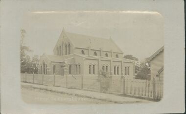
Photograph, undated
The first church building on this site faced Erica St. The "new" church was built in 1929 facing Balwyn Road. The new church was built in memory of Sir Aaron Danks. The Architect was Mr Louis R. Williams, the building contractor was Mr A. Richardson.Sepia photograph in postcard format of the Balwyn Road Methodist Church, Canterbury. The photograph shows two church buildings and part of a hall behind a picket fence.balwyn road methodst, canterbury, erica street, sir aaron danks, mr louis r. williams, mr a. richardson -
Canterbury History Group
Photograph - Garden of "Roquebrune" corner of Canterbury Road and Gascoyne Street Canterbury, c1920
"Roquebrune" built in 1912 or 1914 by G.H.Tarrrant and demolished in 1971 to make way for the Baptist Nursing Home on the corner of Canterbury Road and Gascoyne Street Canterbury. Now apartmentsGarden and side of the house "Roquebrune" built in 1912 or 1914 by G.H.Tarrrant and demolished in 1971 to make way for the Baptist Nursing Home on the corner of Canterbury Road and Gascoyne Street Canterbury. Now apartmentscanterbury, canterbury road, gascoyne street, roquebrune, edwardian style, baptist nursing home, aged people, nursing homes, garden -
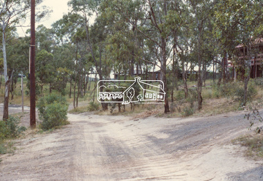 Eltham District Historical Society Inc
Slide, Shalbury Avenue, Eltham, c. Jan 1983
... roads ...Roll of film taken by Eltham Shire Council officers of the Beard street group, a private street scheme, before construction commenced. They provide perspective of the changes in housing styles and road development that began sweeping in from the mid 1970s with increasing urbanisation of what was once more outlying suburbs and regions.35 mm colour positive transparency (1 of 7) Mount - Blank Card,eltham, housing estate, infrastructure, private street scheme, roads, shalbury avenue -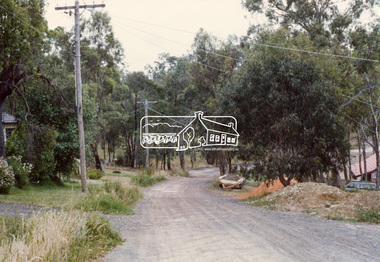
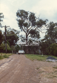 Eltham District Historical Society Inc
Slide, Andrews Street, Eltham, c. Jan 1983
... roads ...Roll of film taken by Eltham Shire Council officers of the Beard street group, a private street scheme, before construction commenced. They provide perspective of the changes in housing styles and road development that began sweeping in from the mid 1970s with increasing urbanisation of what was once more outlying suburbs and regions.35 mm colour positive transparency (1 of 7) Mount - Blank Card,eltham, housing estate, infrastructure, private street scheme, roads, andrews street -
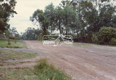 Eltham District Historical Society Inc
Slide, Thomas Street, Eltham, c. Jan 1983
... roads ...Roll of film taken by Eltham Shire Council officers of the Beard street group, a private street scheme, before construction commenced. They provide perspective of the changes in housing styles and road development that began sweeping in from the mid 1970s with increasing urbanisation of what was once more outlying suburbs and regions.35 mm colour positive transparency (1 of 7) Mount - Blank Card,eltham, housing estate, infrastructure, private street scheme, roads, thomas street -
 Eltham District Historical Society Inc
Slide, Andrews Street, Eltham, c. Jan 1983
... roads ...Roll of film taken by Eltham Shire Council officers of the Beard street group, a private street scheme, before construction commenced. They provide perspective of the changes in housing styles and road development that began sweeping in from the mid 1970s with increasing urbanisation of what was once more outlying suburbs and regions.35 mm colour positive transparency (1 of 7) Mount - Blank Card,eltham, housing estate, infrastructure, private street scheme, roads, andrews street -
 Eltham District Historical Society Inc
Slide, Frank Street, Eltham, c. Jan 1983
... roads ...Roll of film taken by Eltham Shire Council officers of the Beard street group, a private street scheme, before construction commenced. They provide perspective of the changes in housing styles and road development that began sweeping in from the mid 1970s with increasing urbanisation of what was once more outlying suburbs and regions.35 mm colour positive transparency (1 of 7) Mount - Blank Card,eltham, housing estate, infrastructure, private street scheme, roads, frank street -
Whitehorse Historical Society Inc.
Article, Pioneers pass, 1926
Obituary for Mr H.H. Hatfield, well known orchardist.Obituary for Mr H.H. Hatfield, well known orchardist. As a teenager he was engaged clearing a road to Woods Point goldfields. He was manager for Theo. Kitchen 7 J.A. Kitchen at Pakenham and he interested them in the fruitgrowing industry. Several times he was president of the Central Fruitgrowers Association. In the early 1890s he started fruitgrowing on his own at Pakenham and later moved to Middleborough Road to live and start an orchard. He was president of Nunawading Shire 1917 -1918.Obituary for Mr H.H. Hatfield, well known orchardist. orchards, hatfield, h.h., central fruitgrowers association, kitchen, theo, kitchen, j.a., shire of nunawading -
 Kew Historical Society Inc
Photograph - Bennett Family Gathering, 22 Harp Road
In 1980, Mr Laurie Bennett presented the Kew Historical Society with a number of photographs and postcards from the estate of his mother Eileen Mary Bennett (nee Clark). His mother was the daughter of Lawrence FH Clark(?-1946) and Mary Clark (?-1925) of 22 Harp Road, East Kew, in whose yard the photograph was taken. A year before the donation occurred a notice appeared in the Canberra Times stating that: "BENNETT, Eileen Mary. — May 8th at Tuross Heads, N.S.W. Late of 22 Harp Rd, East Kew, (Vic). Dearly loved wife of the late Harold Bennett, loved mother and mother in law of Laurie and Shirley (Melbourne), Kevin and Doreen (Canberra), grandmother of Linda, Stephen, Paul, Gabrielle, Peter, Mark and Jon."Part of a large collection of photographs and postcards in the collectionFamily portrait of members of the Bennett family of 22 Harp Road, East Kew. laurie bennett, eileen mary bennett, eileen mary clark -
Whitehorse Historical Society Inc.
Document, Villa Residence, 11/12/1937 12:00:00 AM
Auction brochure for 'beautiful modern brick villa residence', with 4 1/4 acres of land, Mitcham Road Mitcham, Saturday December 11 1937.Auction brochure for 'beautiful modern brick villa residence', with 4 1/4 acres of land, Mitcham Road Mitcham, Saturday December 11 1937, under instructions from the executors of the estate of the late E. E. Walker. Frontages to Mitcham Road, Delhi Street and Agra Street. Auctioneers: Baillieu Allard in conjunction with Drake & Co. Original copy framed, located in Map Drawer.Auction brochure for 'beautiful modern brick villa residence', with 4 1/4 acres of land, Mitcham Road Mitcham, Saturday December 11 1937.walker, edgar edwardes, walker estate, mitcham road, mitcham, delhi street mitcham, agra street, mitcham, drake & co., baillieu allard pty ltd -
 Kew Historical Society Inc
Photograph - In the 'Alexandra Gardens', Kew, 1927
The Alexandra Gardens in Cotham Road, Kew were opened by the Governor of Victoria in 1910. The first curator of the gardens was George Pockett, who with his brother is credited with the layout of the gardens. The gardens were constructed on land originally owned by the King family of 'Madford' in Wellington Street. The land on which the gardens were developed was originally the back paddock of 'Madford' which was purchased by the Borough of Kew in 1906.A rare and early photograph of the gardens showing clearly the changes to the layout and planting during the 1920s. Small, sepia coloured photographic positive of a woman standing beside a path and bridge in the Alexandra Gardens in Cotham Road, Kew.Annotation verso: "Alexandra Gardens Kew 1927"parks and gardens -- kew (vic.), alexandra gardens -- kew (vic.), george pockett -
Whitehorse Historical Society Inc.
Document, Sylvia's memory gem
Sylvia Pilven, who is a local resident, relates stories of her life to Dorothy Williams.Sylvia Pilven, who is a local resident, relates stories of her life to Dorothy Williams. She was the last of the Williamson Family and lived to 98, dying in 1907. The Williamson family property was in Mt Pleasant Road TunstallSylvia Pilven, who is a local resident, relates stories of her life to Dorothy Williams. williamson, alfred, williamson, isabella, mount pleasant road tunstall -
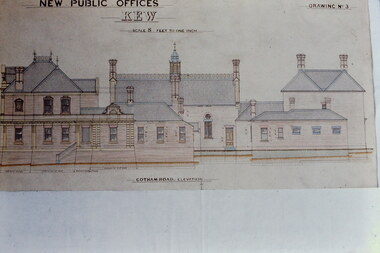 Kew Historical Society Inc
Slide - Architectural Drawing, Kew Public Offices, 1887
A civic campaign for new public offices developed in Kew in the 1880s. After much deliberation, the location chosen was the junction of Bulleen and Cotham Roads. The buildings were designed by George Watson and John Henry Harvey, architects within the Department of Public Works (Victoria). Building was commenced in 1887, and after one year, the buildings were opened. The Post Office was transferred to the new Commonwealth Government in 1901. The Police Station and Court House, sold by the Victorian Government to the City of Boroondara in 2007, are now a community cultural centre and performing arts venue.The buildings were listed on the Victorian Heritage Register Register (HO885) in 1991. They are historically and architecturally significant to the State Of Victoria because Watson and Harvey's designs exhibit diversity in integrating civil offices, they accommodate the apex of road junctions, and they demonstrate a departure from the contemporaneously favoured High Victorian Classical to the Queen Anne style in the design of civic buildings. 35mm colour transparency of an original plan by George Watson and John Henry Harvey, architects of the Department of Public Works (Victoria), in 1887 for New Public Offices at Kew. This plan was copied by the donor from an original held at the Commonwealth Archives in Brighton (Vic). The copy was made to illustrate a report that the donor made on ‘The functional planning design, building materials and construction methods of the Kew Post Office’ as part of course work at RMIT.NEW PUBLIC OFFICES KEW / SCALE 8 FEET TO ONE INCH / COTHAM ROAD ELEVATIONkew court house, kew police station, kew post office, architectural drawings, khs - slides, new public offices -- kew (vic.), architecture — queen anne style -
 City of Kingston
Pamphlet - Colour, R. Malcolm Estate Agents et al, Last Chance Land Sale Heritage Estate Cheltenham, c.1994
Sales plan for land in the suburb of Cheltenham, bounded by Chesterville Road and Bernard Street, and incorporating Clendon Court, Tintern Grove and Tintern MewsThis land sale pamphlet illustrates one of the last subdivisions of the century in Cheltenham, incorporating house and land packages. It shows that land sales and subdivision for the area had slowed considerably by the end of the 1900s and that the infrastructure was significantly developed. Colour pamphlet advertising last chance land sale of Heritage Estate Cheltenham. Incorporates a map of the estate bordered by Chesterville Road and Bernard Street, and including Clenton Court, Tintern Grove and Tintern Mews.cheltenham, land sales, estate