Showing 13444 items matching "stations"
-
 Bendigo Military Museum
Accessory - INSTRUMENT - NAVIGATIONAL AID
Navigational aid used during WW11Instrument for altitudes & air speed corrections. Notebook with spiral binding attached inside.Scratched on inside of stainless steel surface of cover: A G Culvenor 46 Station St. Nunawading instruments, military history - airforce, aviation, mechanics -
 Ringwood and District Historical Society
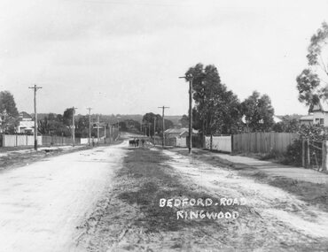
Photograph, Bedford Rd. 1920. Looking towards Ringwood Railway Station at end
Typed below photograph, "Bedford Rd. 1920. Looking towards Ringwood Railway Station at end". -
 Ringwood and District Historical Society
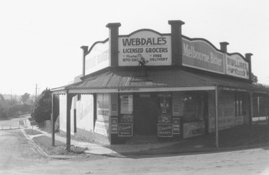
Photograph, Webdale's Licensed Grocer, Station Street, Ringwood 1976
Photograph dated, 1976. Catalogue card reads, Webdale's Licensed Grocer, Station Street, Ringwood". -
 Ringwood and District Historical Society
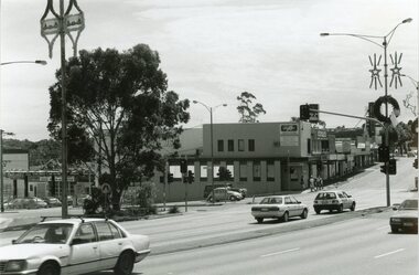
Photograph, Ringwood black and white photographs
Black and white photographMaroondah Hwy. view to NE. across former clocktower site from Station vehicle entrance -
 Ringwood and District Historical Society
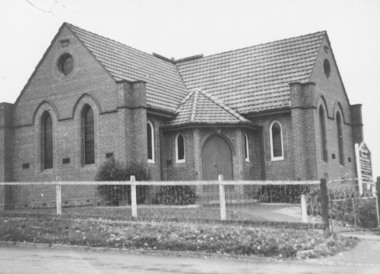
Photograph, Ringwood Methodist Church, cnr Greenwood Av. & Station St., Ringwood - circa 1920s
Written on backing sheet, "Ringwood Methodist Church, C/R Greenwood Av. & Station St." -
 Ringwood and District Historical Society
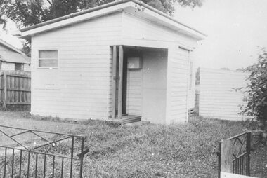
Photograph, Ringwood Police Station, Pratt Street - 1960
Typed below photograph," Ringwood Police Station, Pratt Street - 1960". (Later taken to Scoresby). -
 Ringwood and District Historical Society
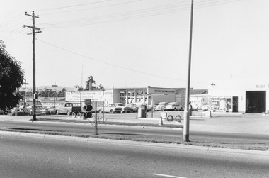
Photograph, Maroondah Highway West, Ringwood- 1969. Looking east from near New Street
Black and white photographWritten on back of photograph: "May 1969". Image shows Mazda showrooms and Mobil Service Station. -
 Ringwood and District Historical Society
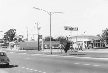
Photograph, Maroondah Highway West, Ringwood- 1969. Looking east near Wantirna Road
Black and white photographWritten on back of photograph: "May 1969". Image shows 'Seaboard Finance', and 'Shell Service Station'. -
 Port Melbourne Historical & Preservation Society
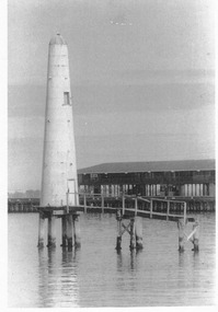
Photograph - Outer beacon showing remaining portion of jetty, c. 1977
Black and white photograph of outer beacon, showing remaining portion of jetty and part of Prince's Pier c 1977In ink: 'Lighthouse between Princes Pier and Station Pier' '191' 'Roger Gould Neg No.' 'C.C.'transport - shipping, leading lights -
 St Kilda Historical Society
Photograph, Victorian Railway Tram, c. 1950s?
black and white photograph (2 identical, unmounted)St Kilda Railway Station with Victorian Railway Tram. From St Kilda to Brighton Beach. -
 Victorian Apiarists Association
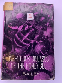
Publication, Infectious Diseases of the Honey-Bee (Leslie Bailey), 1963
A5 sized hard cover book with a black inner cover, outer cover is purple paper with photo of a bee on the front & cream writing. The back is cream with black & purple writing listing diseases. Inside the front cover is a blurb about the book & inside the back cover is a blurb about the author Author Leslie Bailey, M.A., PH.D Rothamsted Experimental Station Illustrations by J Phillip Stradbery -
 Ballarat Tramway Museum
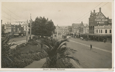
Photograph - Digital image, Tramway Museum Society of Victoria (TMSV), c1930
Yields information the appearance of Sturt St from Lydiard St looking east, with a number of vehicles and building sin the background.Digital image from the Wal Jack Ballarat Album of a postcard looking south east from the intersection of Sturt and Lydiard St with Suttons store and Boots in the background - c1930 with a number of motor cars in the street scene. Post card has title "Sturt St Ballarat" and number "1370". Manufacture of postcard not shown. For rear of postcard - see image i2.On rear of photograph in pencil "Ballarat Railway Station 27-12-32" and "3d" in the stamp box.trams, tramways, sturt st, esco -
 Ringwood and District Historical Society
Photograph, Maroondah Highway Central, Ringwood. Railway Station entrance, 1969
Black and white photographImage shows ES&A Bank to left, Chemist and Jimmy's Handy Bar towards station entrance. -
 National Wool Museum
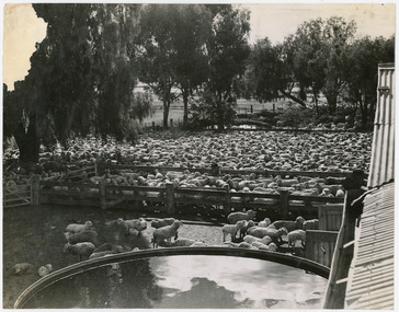
Photograph - Sheep in Shearing Shed Yards, 1960s
One of fifty one photographs originally in a photo album found in the National Wool Museum’s office. The album was water damaged and the images were removed for conservation. The images follow the process of wool. Beginning in a sheep paddock and finishing as a folded fabric. It includes all the steps in between in this process, including shearing, transporting, selling, washing and the many different steps in the process of turning a single thread of wool into fabric.Black and white image showing sheep in stockyards with water tank in foreground.W43 / AUSTRALIAN NATIONAL [?] / ASSOCIATION / FLINDERS STREET [?] / MELBOURNE / Ya[?] Shearing shed / [?]nooke Stationwool industry, working life, women, boonoke station, farming, sheep farming, agriculture, sheep stations, transport, wool processing, shearing, textile industry, wool -
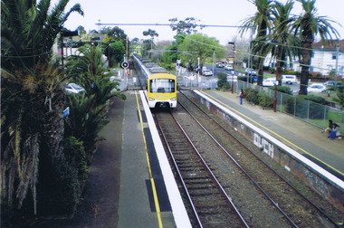
 Ringwood and District Historical Society
Photograph, Ringwood Railway Station overlooking Maroondah Hwy viewed from bridge over Warrandyte Road in foreground, 1974
Black and White photographWritten on back of photograph, "Ringwood Railway Station, 1974 from bridge over Warrandyte Road." -
 Ringwood and District Historical Society
Photograph, Ringwood Railway Station, 1974, viewed from bridge over Warrandyte Road in foreground, looking west
Black and White photographWritten on back of photograph, "Ringwood Railway Station, 1974. From bridge over Warrandyte Road". -
 Ringwood and District Historical Society
Photograph, New East Ringwood railway station - 1975. (Replacing old building)
Black and white photographWritten on backing sheet, "New East Ringwood railway station - 1975. (Replacing old building)". -
 Ringwood and District Historical Society
Map, Plan of Subdivision - State School Estate, Ringwood East, Victoria - (Undated, circa 1920s)
Map of land for sale attached to green cardboard backing with handwritten notations showing numbered allotments on Dublin Road, Holland Road, King Street, Charles Street and Purser Avenue, Ringwood East.Locality plan includes reference to proposed Ringwood East railway station which opened in 1925. -
 Bendigo Historical Society Inc.
Photograph - Napoleon Reef Gold Battery Winder Shed, 1936
The Napoleon mine site was situated near Harvey Street and Union Street, Ironbark. It was registered under the Companies Act in 1940, with John Jepson Stanistreet as Manager. Article in Age newspaper: https://trove.nla.gov.au/newspaper/article/206767750?searchTerm=napoleon%20reef%20mineSignificant to mining history of Bendigo.Black and white photograph: large wooden frame for winder shed, carpenters' 'horses' in foreground. Written in pencil on back of photograph: ' ...winder shed 21/10/36' and 'cracker station building'napoleon gold mine, napoleon reef gold mine -
 St Kilda Historical Society
Photograph, Ethan Lawrence, 2009
Photograph taken in 2009Colour photograph, mountedI took this picture on the bridge at Ripponlea train station. It shows what the station is like. Two platforms (City, Sandringham) Palm trees that are old and were established with the English people came and settled over Australia. By Ethan Lawrenceripponlea, glen eira road, railway, ripponlea station, ripponlea state school -
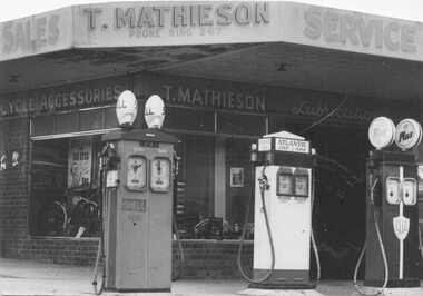 Ringwood and District Historical Society
Photograph, Mathieson shop at Station entrance. c1940's
Black and white photograph (2 copies- 1 large, 1 small)Typed on backing sheet: "Kerbside pumps at station entrance". Written on back of large photograph: "Bike repair shop and petrol. Sold to CBC for their Ringwood Bank, westside of entrance to railway station". Written on back of small copy: "On right hand corner of entrance to Ringwood Railway Station. Kerbside pumps, also did big business in bikes and repairs. c1940's." -
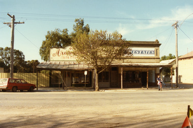 Charlton Golden Grains Museum Inc
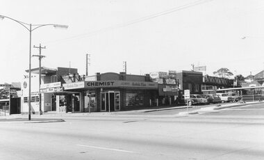
Photograph, Arundell's Shoe Shop, High St Charlton c. 1987, c.1987
Arundell's Shoe Shop and Dalgety's Agency , centre of High St Charlton, north side c. 1987. Corner of High St and Williams Ave (now John Curtin Drive). Right hand building built by William Williams as a saddlery c. 1910. Arundell's Shoe Shop formerly ANA Boot and Shoe Shop established by John Arundell in 1901. The shop was sold by Vic Arundell in 1980 and closed. Next door was John Watson's Stock & Station Agents which later became Dalgety's. The end shop was the saddlery and then Bullock's grocery 1930's to 1970's. In 1957 became Charlton's first self service store. Became Australian Estates late 1970s. The shops were later demolished to make way for the Traveller's Rest. Part of a streetscape series taken in 1987 for the Charlton Shire.Colour photograph of three single-storey shops with corrugated tin verandahs. Signage on the buildings reads Arundell's SHOE STORE and ESTATES. Partially obscured by tree in front of the buildings. A red station wagon is parked on the LH side of the picture and a boy on a bicycle on the RH side. arundell, dalgety's, williams saddery, john watson stock & station agent, bullock's grocery, australian estates, arundell's shoe store, business, industry, charlton -
 Melbourne Tram Museum
Photograph - Set of 5 Black & White Photograph/s, Department of Infrastructure (DOI), 1999
Set of 5 black and white photographs of the Glenhuntly depot sub-station, taken by the photographic section of the Dept of Infrastructure during early 1999. .1 - interior view of sub-station showing a rotary converter, crane rail and substation equipment. .2 - ditto .3 - High Voltage cable entry points .4 - view of Glenhuntly Depot showing location of sub-station through the large doors. .5 - Transformer with Mike Ryan standing alongsideEach photo has on the rear a "Copyright Department of Infrastructure with details for reordering and a hand written numbers - 1999 - 101 to 110 (not all photos printed).trams, tramways, substation, rotary converters, glenhuntly tram depot -
Ringwood and District Historical Society
Newspaper cutting, Ringwood Mail cutting arguing for and against demolition of the clocktower. Also 1963 receipt from ClockTower Service Station
Cutting from Ringwood Mail 25 March 1965 about clock tower - Demolish The Clock Tower "Yes" - C.R.B., "No" - R.S.L.; Photocopy of 1963 receipt from Clock Tower Service Station to Carl Gale +Additional Keywords: Gale, Carl / Clock Tower Service Station -
 Whitehorse Historical Society Inc.
Postcard, Mitcham Railway Station, Teacher's Residence, St. John's Catholic Church and Mitcham's First Police Station, 1910
Black and white photo of L - R : Mitcham Railway Station (at rear)|Teacher's Residence, St.John's Catholic Church|and Mitcham's First Police Station..(The 'great three chain road' in the foreground is now Maroondah Highway - see annotated photograph on north wall of Local History Room)wright, syd, mitcham railway station, st. john's catholic church, mitcham, mitcham police station -
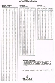 Melbourne Tram Museum
Ephemera - Timetable, The Met, "St Kilda - City Rail Replacement Bus Service", Jul.. 1987
Timetable - photocopy onto both sides of a sheet of paper, "St Kilda - City Rail Replacement Bus Service", effective 1 August 1987. Lists times for the stops at the then stations, including Flinders St station. Has The Met logo on the base of the sheet. Two copies held.trams, tramways, st kilda, light rail, conversion, timetables, bus replacement -
 Melbourne Tram Museum
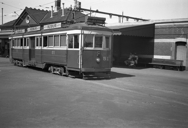
Negative, Wal Jack, 27/12/1939 12:00:00 AM
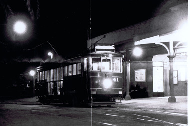
Black and white negative, of Victorian Railways tram 51 at the Sandringham Railway Station with the station building in the background. Tram has the destination of Black Rock and Robur tea advertisements. Photo not in the Wal Jack Victorian Railways Album. Possibly the same date as htd5963i - 27-12-1939trams, tramways, victorian railways, vr trams, sandringham, tram 51 -
 Melbourne Tram Museum
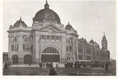
Photograph - Black and White photograph, c1905
Black and White photograph titled "New Railway Station Melbourne" looking at Flinders St Railway Station from St Paul's. Has a cable tram set in the view and many people walking across the intersection. Most likely made for the 70th anniversary of South Melbourne Depot.trams, tramways, flinders st, swanston st, flinders st station, cable trams -
 Kew Historical Society Inc
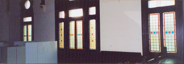
Photograph - Former Kew Court House : Windows in Court Room, 1996
A civic campaign for new public offices developed in Kew in the 1880s. After much deliberation, the location chosen was the junction of Bulleen and Cotham Roads. The buildings were designed by George Watson and John Henry Harvey, architects within the Department of Public Works (Victoria). Building was commenced in 1887, and after one year, the buildings were opened. The Post Office was transferred to the new Commonwealth Government in 1901. The Police Station and Court House, sold by the Victorian Government to the City of Boroondara in 2007, are now a community cultural centre and performing arts venue.The buildings were listed on the Victorian Heritage Register Register (HO885) in 1991. They are historically and architecturally significant to the State of Victoria because Watson and Harvey's designs exhibit diversity in integrating civil offices, they accommodate the apex of road junctions, and they demonstrate a departure from the contemporaneously favoured High Victorian Classical to the Queen Anne style in the design of civic buildings.Photograph of tall leadlight windows in the former Court Room (now the Just Theatre) of the Kew Court House. The photograph in the lower right corner shows part of the magistrates bench (now removed). Other items in the room include police lockers, as at that stage, in 1996, the room was occupied by the Kew Police Station and used as a briefing room and locker room.kew court house, public offices -- kew (vic.), court room -- victoria, kew police station -
 Bendigo Military Museum
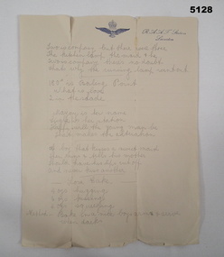
Literary work - ROMANTIC POETRY, RAAF Letterhead
See Cat 5109PSingle page of paper. It has the letterhead of RAAF Station, Laverton. It has eight little poems written in pencil.ww2, poetry