Showing 19894 items
matching east-malvern
-
 Melbourne Tram Museum
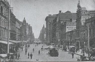
Postcard, "Collins St Melbourne looking East", 1900's
Postcard - silver finish known as "Collotype"- view of looking west along Collins St from near the intersection of Swanston St. Included in the view are the Coles Book Arcade, T.Hump Artist, Melville Booksellers, Sears Photographic Studios and Lambert & Hairdressers. Card titled "Collins St Melbourne looking East" Postcard has a divided back with space for stamp, address and correspondence. In the top centre is a start with an "O" in the centre.trams, tramways, cable trams, swanston st, collins st, buildings -
 Ringwood and District Historical Society
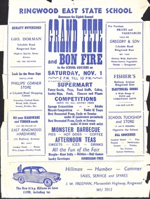
Flyer, Ringwood East State School Eigth Annual Grand Fete and Bon Fire. No date
A flyer announcing the Eighth Annual Grand Fete and Bon Fire in the school grounds on Saturday November 1. 2 pm till 10 pm. Supermart, Competitions, Monster Barbecue, Afternoon Teas. Advertising by GEO Dorman Quality Butcheries, Fruits and Vegetables Gregory & Son, Phillips Corner Store, Fisher's Electrical Goods, East Ringwood Hardware, J. W. Freeman, and All Groceries F and B Preiser. -
 Melbourne Tram Museum
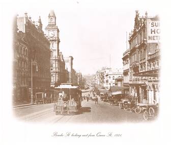
Photograph - Black & White Photograph/s, "Bourke St looking east from Queen St 1921", 1980's?
Reproduced photograph, sepia toned of "Bourke St looking east from Queen St 1921" with the Post Office, Myers, the Leviathan, and Parliament House in the distant background. Also a shop "Hatters Kenos Mercers" The cable tram has the destination of "Spencer St" One of a series of four photographs produced by an unknown person/company. Two small size prints held. See Reg Items 301 and 5274 for other copies.On the rear of 587 "Cable Tram prints $10/set"trams, tramways, melbourne, bourke st, cable trams, post office -
 Greensborough Historical Society
Map, Melbourne and Metropolitan Board of Works. Survey Division, MMBW, Yarra 2500 / 11.21. Bundoora, east of Plenty Road, 1979_01
Melbourne and Metropolitan Board of Works. Yarra 2500 [base map] 11-21. Bundoora, east of Plenty Road. Parish of Keelbundoora 2856, Municipalities of Diamond Valley 257, Preston 225 and Whittlesea 239. Prominent streets include: Grimshaw Street, Settlement Road and Plenty Road. Includes Yulong Park.MMBW Map in 1:2500 [scale] series. Cream parchment with green tape reinforcing on edges and punched holes on left edge.mmbw, melbourne and metropolitan board of works, shire of diamond valley, bundoora - maps -
 Whitehorse Historical Society Inc.
Clothing - T-Shirt, C. 1970-1993
Refer to NA4362White short sleeved polyester/cotton T-Shirt with the 'Blackburn East' Primary School crest printed on the front. Printed in burgundy.Blackburn Eastcostume, children's uniform -
 Whitehorse Historical Society Inc.
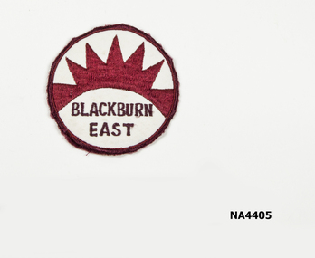
Decorative object - Cloth Badge, School, 1980s
See Ref. 4362Round material school badge. Cream/Maroon edge on maroon rising sun and Blackburn East printed under the sun in black.Blackburn Eastnumismatics, badges, school, equipment, costume accessories, clothes accessories -
 Ringwood and District Historical Society
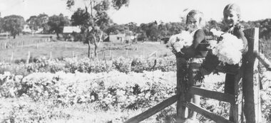
Photograph, Hazel Howship and Merle Purser with chrysanthemums at Lutch Floral Farm, East Ringwood,1939
Black and white photographAccompanying sheet of paper reads- "Chrysanthemums. Inspecting chrysanthemums while sitting on the gate of the Floral Farm of Mr. S. R. Lutch at East Ringwood on 24th April 1939. Hazel Howship and Merle Purser, daughter of Cr. Purser." "This photo appeared in the 'Herald' on Saturday Nov. 8th, 1958."agriculture -
 Ringwood and District Historical Society
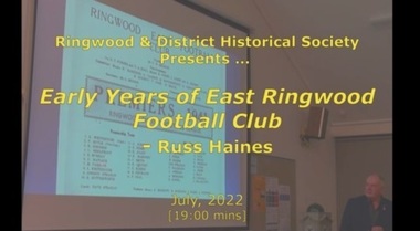
Mixed media - Video, RDHS Meeting Presentation - "Early Years of East Ringwood Football Club" - Russ Haines
Digitised video (776MB). Duration: 19 minutes. Recorded July, 2022 (Video is available for viewing at Ringwood & District Historical Society Archives by appointment)In this presentation, Russ Haines, Ringwood and District Historical Society President and ERFC historian, talks about early Australian Rules football in the local area from the time of the formation of the East Ringwood Football Club, through the 1930s, the war years, and the era leading up to the historic 1947 Premiership. -
 Lakes Entrance Regional Historical Society (operating as Lakes Entrance History Centre & Museum)
Album - Photograph, LERHS members, 2010 c
Small album of colour photographs taken in areas of East Gippsland and of trips to Bruthen and Sale, East Gippsland Victoriaworld war 1914-1918, world war 1939 - 1945, military history -
 Ringwood and District Historical Society
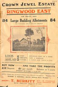
Flyer, Subdivisional Land Sale Brochure, Crown Jewel Estate, Ringwood East, Vic. - c.1925
In May 1884, George Smart of Bulleen Road Kew, brickmaker, bought the 23 acres one rood and twenty nine and three tenths perches, or 9.4834 hctares from Arthur Bailey Clements of Ringwood for the sum of 600 pound sterling. (Extract from The Story of the Crown Jewel Estate in Ringwood East pdf)Double sided folded page with black and red print on both sides advertising auction sale of residential and business sites and highlighting local facilities, services and layout of the estate.Subdivision includes Mount Dandenong Road, Valda Avenue, Evon Avenue, Mirabel Avenue, and Velma Grove. (Agent) T. Burkitt, Box 12 Ringwood, Phone Ringwood 157. Vendor: A. Marshall Miller, McDonald Street, Mordialloc. Solicitors: Russell, Bona and Russell, 19 Queen Street Melbourne, and Ringwood - Phone Cent. 4308. -
 Greensborough Historical Society
Photograph - Digital image, Frank Robinson, Looking south east from Pope's paddock to the railway line, 1954_
Looking south east from Pope's paddock to the railway line. The Blackjack property, house and acres of fruit orchards ran down to the Plenty River off Hume Street Greensborough and was the home of the Robinson family to late 1956. The photographs were taken as slides by Frank Robinson and digitised by his son James in 2015.Digital copy of colour photograph.robinson family, popes paddock -
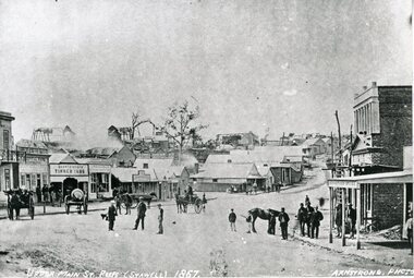
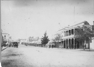 Stawell Historical Society Inc
Photograph, Main Street Stawell looking East with the Town Hall Hotel on the right c1890
Main street scene, Town Hall Hotel on the right. Horse drawn vehicle on left in the street. People standing under verandah on footpath. Showing W. Shorts Hotel also known as the Town Hall Hotel. Looking East up Main Street. Visible Post Office Hotel, Spragues Sporting DepotSepia photograph of a scene of Main St Stawell. Town Hall Hotel on the right. Horse drawn vehicle on left in the street. People standing under veranda in foot path. Trees in Street.Miss E. Moulden 54 Dawson St Stawell stawell shops businesses streetscape -
 Melbourne Tram Museum
Document - Research Notes, H. S. McComb, Bourke St to Nicholson St line, Brunswick East line, c1930
Notes 10 pages, pinned together, giving details, opening dates, terminals, depot entries, sheave pits, curves, for the Bourke St to Nicholson St line, Brunswick East, including the connection into Spencer St. Includes 2 pages pinned together for the Gertrude, Smith St to Queens Parade line. Items 2064 to 2075 within box 72.3 in a brown folder marked "MT&O Co." red pencil on the front cover.trams, tramways, mto co, cable trams, drawings, reports, surveys, bourke st, nicholson st, gertrude st, smith st, queens parade -
 Stawell Historical Society Inc
Photograph, Upper Main Street Looking East 1886
Upper Main Street Looking East 1886. From left J Allingham Drapers. J Chadwick & Co Drapers. Bank of Victoria partly obscured, Commercial Hotel, Oriental bank, Punchard's Furniture. On right is the side of Mechanics Institute obscured. B.S. Dawson Chemists & Wadsworth Watchmaker. English Scottish & Australian Bank . Upper Main Street scene with people standing in roadway, Side of cart visible on left. c 1880stawell streetscape -
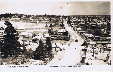 Ballarat Tramway Museum
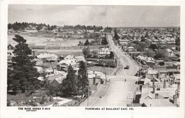
Photograph - Digital image, Rose Stereograph Co, "Panorama at Ballarat East Vic", c1914
Photo looks west from the Ballarat Fire Station (East) tower, and has a good view looking along Barkly St. Shows the crossing loop between Eastwood and Main St with one tram in the view. Wal has dated the photo as 1914 in his album notes. See item 8243 for an actual postcard. Yields information the buildings, buildings and scene looking west from the Fire Station tower along Barkly St. East BallaratDigital image of a postcard from an album compiled by Wal Jack, loaned to the Museum. The Rose Series Postcard No. P 4614. For rear of postcard - see second image.trams, tramways, esco, ballarat east, barkly st -
 Ballarat Tramway Museum
Postcard, Rose Stereograph Co, "Panorama at Ballarat East Vic", c1916
Photo looks west from the Ballarat Fire Station (East) tower, and has a good view looking along Barkly St. Shows the crossing loop between Eastwood and Main St with one tram in the view. Wal has dated the photo as 1914 in his album notes. On rear Wal Jack has written "Looking up Barkly St towards Mt Pleasant. Photo taken from Ballarat Fire Station about 1914-1916 period. Old type tram from Mt Pleasant about to turn into Main St. Note old passing loop behind tram. Loop removed to top of rise in centre background. Old Ballarat East Gardens on left and council yards, showing big tin shed in centre of picture. Locality much altered today." See item 5127 for a digital image.Yields information about the buildings and scene looking west from the Fire Station tower along Barkly St. East BallaratPostcard Black and white - Rose Series No P4614, Divided back. No publishers details on rear.See image 2 for Wal Jack's notes.tramways, trams, esco, ballarat east, barkly st -
 Wodonga & District Historical Society Inc
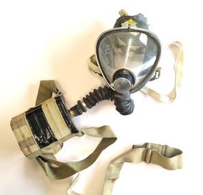
Tool - Sieba Gordon Gas Mask - North East Water Authority, Siebe Gorman & Co. Ltd, c1960
This mask set is part of the North East Region Water Authority collection in the Wodonga Historical Society. Wodonga's drinking water and wastewater operations were originally managed by the Wodonga Waterworks Trust, which was established in 1897, after Wodonga became a separate shire in 1876. In 1923 a Wodonga Waterworks Trust referendum to provide funding for new infrastructure to supply more water of better quality to Wodonga was passed. This included building the Wodonga Water Tower and it was completed in 1924. It supplied water to Wodonga until 1959, when it was drained and decommissioned after the No 1 Basin on Huon Hill was completed in 1958. In 1983 the Wodonga Waterworks Trust and the Wodonga Sewerage Authority became part of the Wodonga Council. And by 1989 a filtration plant at Huon Hill was completed, which provided filtered water of improved quality to Wodonga, in accordance with the World Health Organisation’s guidelines. In 1994 the Kiewa Murray Region Water Authority took over the Wodonga Council’s water and wastewater operations, and then in 1999 the Kiewa Murray Region Water Authority combined with the Ovens Region Water Authority and became the North East Region Water Authority or NERWA. NERWA then became known as North East Water. Siebe Gorman was a British manufacturer of industrial respirators that served the mining industry, the chemical industry, and the agricultural industry from 1938 until the 1980s. The "Puretha" line refers to the canister included, which was designed to tackle industrial hazards.Siebe Gorman "Puretha" Type C Kit with Vista Vision Facepiece. The facepiece consists of a formed plastic lens held on by a white retaining ring that stretches around the rubber facepiece and is connected by two thumbscrew lugs. The exhale assembly is covered by a steel mesh.The hose is a standard industrial hose. The canister is attached by a khaki webbing material. An instruction sheet is included. The kit is a small leather case with two front latches. Safety instructions and chemical information on canister label. On label: EVERYTHING FOR SAFETY EVERYWHERE Date filled 28 DEC 1961 NO. 675 north east region water authority, gas mask, respirator, sieba gordon -
 Kew Historical Society Inc
Photograph - Yarra Valley at Kew, 1918
During the nineteenth century, the land abutting the south side of the Yarra in Kew was devoted to dairy farming. In the twentieth century, before and after the construction of the Eastern Freeway, much of this low-lying area was used as golf courses and public parks.View of the farmland in the Yarra Valley at what is believed to be East Kew in 1918. Verso: "Willsmere / East Kew? / 1918"yarra river, yarra valley -
 Ringwood and District Historical Society
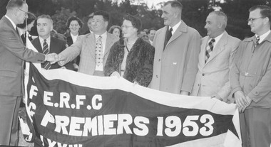
Photograph, East Ringwood Football Club 1953. Committee members with Premiers 1953 Flag
Catalogue card reads, "East Ringwood Football Club (ERFC) 1953. Committee members 1953. L. to R. Gilbert Chandler, Pres. Croydon, F.T. Gully F.L. (CFTGFL) Gordon Cassidy, ERFC, Tom Reddish, Pres. E.R.F.C. Dick Horman E.R.F.C." Includes a proof, probably for Ringwood Mail. -
 Kew Historical Society Inc
Plan - Subdivision Plan, Jas R Mathers Son & McMillan, Macartney Estate, East Kew, c. 1925
Pru Sanderson, in her groundbreaking ‘City of Kew Urban Conservation Study : Volume 2 - Development History’ (1988), summarised the periods of urban development and subdivisions of land in Kew. The periods that she identified included 1845-1880, 1880-1893, 1893-1921, 1921-1933, 1933-1943, and Post-War Development. These periods were selected as they represented periods of rapid growth or decline in urban development. An obvious starting point for Sanderson’s groupings involved population growth and the associated economic cycles. These cycles also highlighted urban expansion onto land that was predominantly rural, although in other cases it represented the decline and breakup of large estates. A number of the plans in the Kew Historical Society’s collection can also be found in other collections, such as those of the State Library of Victoria and the Boroondara Library Service. A number are however unique to the collection.Subdivision plans are historically important documents used as evidence of the growth of suburbs in Australia. They frequently provide information about when the land was sold on which a built structure was subsequently constructed as well as evidence relating to surveyors and real estate and financial agents. The numerous subdivision plans in the Kew Historical Society's collection represent working documents, ranging from the initial sketches made in planning a subdivision to printed plans on which auctioneers or agents listed the prices for which individual lots were sold. In a number of cases, the reverse of a subdivision plan in the collection includes a photograph of a house that was also for sale by the agent. These photographs provide significant heritage information relating house design and decoration, fencing and household gardens.The Macartney Estate subdivision advertised 21 lots for sale on either side of Macartney Street (now Macartney Avenue) and Evans Road in what was then designated as East Kew. Most of the houses shown on the south side of Macartney Street then, as now, have rear entrances on Mount Street, however a number of these blocks have since been further subdivided to allow for the building of new houses on the rear of a block. Brougham Place is marked on the plan but is now called Daniell Place."C"subdivision plans - east kew, macartney estate, macartney street, mount street, evans road, brougham place -
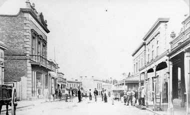
 Stawell Historical Society Inc
Photograph, Upper Main Street looking East from Patrick Street corner across Layzell Street 1866
Upper Main Street looking East. Poppet Heads in Background. Oriental Bank second on left then Quartz Reef Timber Yards. Intersection is Layzell St Main Street. Advertiser Office on right in front of Earlier Mechanics Institute. Part of a collection of Photographs by Mr. O.G. Armstrong as commissioned by the Shire of Stawell for the Inter-colonial and Paris Exhibition in Melbourne in 1866.Upper Main street with Poppet Heads in the background, the Oriental Bank second on left & then Quartz Reef Timber Yard 1867 Advertiser Office on right and earlier Mechanics Institute.Upper Main Street Reefs 1867stawell mining streetscape -
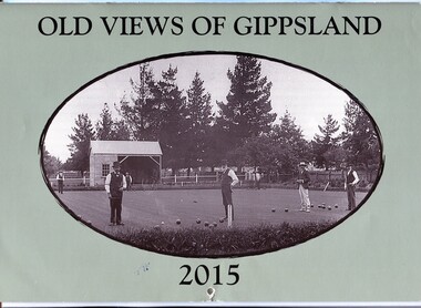 Orbost & District Historical Society
calendar, Old Views of Gippsland 2015, 2014
This is one of a series of calendars compiled and published by east Gippsland Historical Society.This is a useful reference tool.A 2015 stapled calendar, titled "Old Views of Gippsland". On the pale green coloured front is a black/white photograph of a Bowling Club Opening Day 7 December 1901 in front of trees in botanical gardens in the background. The photograph is credited as from the Ron Yeats Collection. The calendar contains early photographs of East Gippsland, one for each month. There is a hole for hanging. The title is at the top and the year at the bottom in black print. calendar-old-views-gippsland-2015 photographs-historic-gippsland -
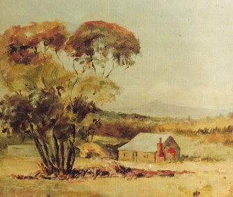 Ringwood and District Historical Society
Photograph, Painting by Mrs. Miles of the first mine manager's cottage at mine site, East Ringwood. (No record of date)
Catalogue card reads, "Print of oil painting done by Mrs. Miles of first miners cottage used for mine manager". Written on back of picture, "Painting by Mrs. Miles of the first mine manager's cottage at mine site, East Ringwood. He was relative of Edith Gluth who lent the painting for photo copying". -
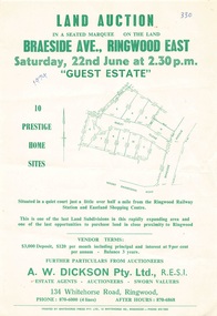 Ringwood and District Historical Society
Flyer - Land Auction, Guest Estate, Ringwood East - 1974
Two copies of single page with green print advertising auction of ten home sites on Saturday 22nd June (1974). Details include subdivision map and vendor terms. Second copy of flyer includes handwritten notation of allotment sale prices.Subdivision layout includes Mount Dandenong Road, Braeside Avenue and Guest Close, Ringwood East. Agent: A.W. Dickson, 136 Whitehorse Road, Ringwood, Phone 870-6000, after hours 870-6868. Printed by Whitehorse Press Pty. Ltd., 14 Whitehorse Road, Ringwood, Phone 870-7855. -
 Greensborough Historical Society
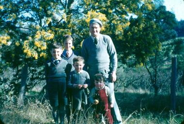
Photograph - Digital Image, Looking north east to the orchard at Blackjack, 1954_
Looking north east to the orchard at Blackjack. The Robinson family (left to right): James, Peter, Paul, Andrew and father Frank. The Blackjack property, house and acres of fruit orchards ran down to the Plenty River off Hume Street Greensborough and was the home of the Robinson family to late 1956. The photographs were taken as slides by Frank Robinson and digitised by his son James in 2015.Digital copy of colour photograph.blackjack, robinson family -
 Expression Australia
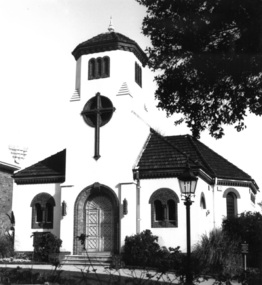
Photograph, Church for the Deaf and Dumb - Jolimont Square, East Melbourne
The Adult Deaf and Dumb Society of Victoria had long wanted its own place of Worship which was realised when this Church built specifically for the Deaf was completed in the Grounds of Jolimont Square, East Melbourne in 1930. This interdenominational chapel was designed by architects Gawler and Drummond for the Society and completed in 1930 in an unusual Romanesque style, although on a much reduced scale from the original design.These photographs are significant as this Church was the first in Australia built speciffically to accommodate the requirement of the Deaf community.16cmHx27cmW and 21cmHx19cmWchurch, jolimont square -
 Stawell Historical Society Inc
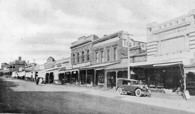
Postcard, Front Cover, Upper Main Street Stawell looking East & & looking West -- 3 Photos -- Postcards 1920's
Views of Stawell. INCLUDES view of Main Street looking East showing from right Strangio & Pizione fruit shop. Sun Printing Works. Tea Rooms. King. Carters Boot Shop. Taylor. Bull and Mouth in distance. Car visible. ALSO Main Street Looking West showing from right Norman A Harding Taylor and Outfitter. Geo Mitchell & Sons stawell businesses streetscape -
 Kew Historical Society Inc
Plan - Subdivision Plan, Shop Sites, East Kew, c.1927
Subdivision plans are historically important documents used as evidence of the growth of suburbs in Australia. They frequently provide information about when the land was sold on which a built structure was subsequently constructed as well as evidence relating to surveyors and real estate and financial agents. The numerous subdivision plans in the Kew Historical Society's collection represent working documents, ranging from the initial sketches made in planning a subdivision to printed plans on which auctioneers or agents listed the prices for which individual lots were sold. In a number of cases, the reverse of a subdivision plan in the collection includes a photograph of a house that was also for sale by the agent. These photographs provide significant heritage information relating house design and decoration, fencing and household gardens.This is one of a small number of subdivision plans for commercial property in the collection. The subdivision proposed to create six shop sites in High Street between the Harp of Erin and Station Street. The plan shows this stretch of High Street, East Kew already lined with shops that include the hotel on the corner, the new State Savings Bank, a dentist’s surgery and Lambert’s Store. The High Street Tram was to reach Burke Road in 1925, so the proposed subdivision must postdate that event, and the opening of the Bank in 1926.subdivision plans - east kew, high street - east kew -
 Melbourne Tram Museum
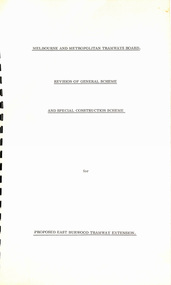
Document - Report, "Revision of General Scheme and Special Construction Scheme for Proposed East Burwood Tramway Extension", 1974
Report - Foolscap bound with black comb binder, 10 pages + two fold out drawings + card covers titled "Revision of General Scheme and Special Construction Scheme for Proposed East Burwood Tramway Extension", not formally dated (1974). Continuing information on the proposal such as route, existing services bus and rail, General Scheme, type of track construction, overhead, costs, fares, resumptions, plans. Includes plans P14604 (shows track arrangement) P14605 general location including the City of Melbourne.trams, tramways, east burwood, new tramways, general scheme, construction -
 Ringwood and District Historical Society
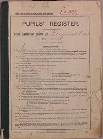
Administrative record, Ringwood East State School No 4180-Pupil Register (Book 1 of 15) Jul 1924 - 12 Feb 1933. Registration Numbers 1 - 362
Ringwood East State School No 4180-Pupil Register Images. A searchable transcript of all these images can be found as a pdf in VC Record 7509. Note: For a high resolution copy of one or more images, contact Ringwood and District Historical Society (RDHS). The original Registers are held at Public Records Victoria (PROV). Scanning of these was commissioned by RDHS and undertaken by Mark Grealy, Archival Access in 2013. (https://www.archivalaccessvictoria.com/). The registers were transcribed in 2021-2022 by Sue Breese, Archivist at RDHS.