Showing 179160 items
matching streets
-
 Eltham District Historical Society Inc
Photograph, Shire of Eltham streetscape
... streets ...Roll of 35mm colour negative film, 3 of 5 stripsKodak CP 100 5094shire of eltham, streets -
 Clunes Museum
Photograph, ROGER PURCELL, 1994
ORIGINAL PHOTOGRAPH OWNED BY MR. WILLIAM HARRIS OF SUTHERLAND STREET, CLUNES. THE ORIGINAL PHOTOGRAPH WAS TAKEN IN CIRCA 1908.BLACK & WHITE PHOTOGRAPH (COPY) CLUNES METHODIST SUNDAY SCHOOL , TEACHERS IN FRONT OF SUNDAY SCHOOL IN SERVICE STREET WITH SENIOR STUDENTS, 1908local history, photography, photographs, churches - wesley -
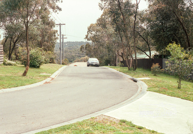
 Eltham District Historical Society Inc
Photograph, Eucalyptus Road, Eltham, 15 October 1990
... streets ...Looking south towards Pitt Street and Nyora Road. Bus stop now on opposite side. Pauline Toner Butterfly Nature Conservation Reserve managed by Parks Victoria on the right hand side. Roll of 35mm colour negative film, 6 of 7 stripsKodak Gold 100-2 5095infrastructure, roadworks - gutters, shire of eltham, streets, eucalyptus road, pauline toner eltham copper butterfly reserve, pauline toner butterfly nature conservation reserve -
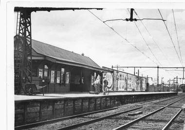 Port Melbourne Historical & Preservation Society
Photograph - Graham Street western railway station, Douglas Smallpage, 1950s - 1960s
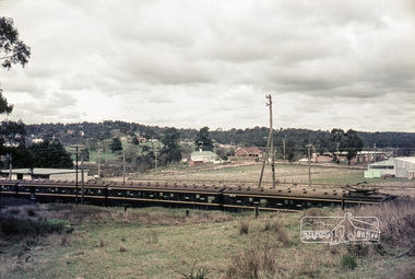
The Graham St Station burned down in the late 1960s. The station site was cleared in the early '70s to make way for the Graham Street overpass.Photograph of Graham Street western railway station taken between late 1950s and late 1960s. Also lasercopies from photo.transport - railways, doug smallpage -
 Whitehorse Historical Society Inc.
Photograph, Colombo Street Mitcham
Property in Colombo Street Mitcham was opposite the train station exit, bought by NADRASCA to train and employ disabled persons. Sold to a developer in 2002Coloured photo of Brewer family house and factory on Colombo Street Mitcham c2002. Factory manufactured bowling balls and tennis racquetnadrasca, colombo street, mitcham -
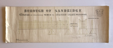 Port Melbourne Historical & Preservation Society
Plan, Charles Clay, Borough Surveyor, Elevation of Proposed Fence to Station Place Reserve, c. 1881
Although undated, the plan is probably from 1880-81. The plan is signed by Charles CLAY, Fred WILLIAMS and Witney Henry BATES. Charles CLAY was the Borough Surveyor from 1860 to 1884. Fred WILLIAMS was a Councillor 1875 to 1886 and served as Mayor, 1880-81. It is not known who Witney Henry BATES was. A note in pencil, probably added later, indicates the fence was between Graham and Bridge Streets.Undated Borough of Sandridge hand-drawn plan for a proposed picket fence at Station Place Reserve.'between Graham and Bridge Streets' handwritten in pencil below and to the right of the main title.local government - borough of sandridge, engineering - fences, charles clay, witney henry bates, frederick williams -
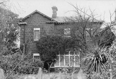 Kew Historical Society Inc
Photograph - 'D'Estaville', Barry Street, c.1970
The Melbourne artist Alma Agnes Marion Figuerola, was the daughter of Juan Pedro Narciso Figuerola (1869-1919) and Alice Lucinda Walker Hanson (1889-1969). Each of their three daughters grew up to be involved in the arts: Alma as a painter; Carmen Irene (1906-1993) as a short story writer, poet and teacher of dancing; and Sylvia (also Silvia) Lyla Alice (1911-1992) as a composer and cellist. The first art lessons Alma Figuerola received were with Oscar Binder. Later she attended the art school established by the Melbourne 'tonalist' [Duncan] Max Meldrum (1875-1955). She graduated from his school in 1920, participating in her first group exhibition in the same year. Solo exhibitions of her work were to be held in 1933 at the Meldrum Gallery in Elizabeth Street, in 1937 and 1945 at the Athenaeum Gallery at 188 Collins Street, and in 1951 at Georges Gallery in Collins Street. Throughout her extensive career she participated in group exhibitions, usually with artists of the Meldrum School, and as a member of the Twenty Melbourne Painters, of which she was invited to become an associate in 1935. In 1953, her portrait of Professor ES Hills was entered in the Archibald Prize Competition of the Art Gallery of New South Wales. A resident of Kew from the 1930s - 51 Studley Park Road, often with her mother, her sister Carmen, or both - from c.1942 until her death she lived at 'D’Estaville', 7 Barry Street. From the late 1930s she is recorded as actively contributing to the arts at a local level. In 1939 and 1940 she participated in art exhibitions at the Hawthorn Municipal Library organised by Jessie Carbines. From 1944 to 1951 she co-organised successive Kew Arts Festivals, initially in the Presbyterian Church Hall in Highbury Grove and later at the Recreation Hall in Wellington Street. A foundation member of the Kew Historical Society in 1958, Alma Figuerola remained an active member of the Society until her death on 8 December 1970. She predeceased her two sisters who both died in the 1990s and who are buried at Andersons' Creek Cemetery in Warrandyte.Part of a photographic series which is historically and aesthetically significant. The photographs record the interiors and exteriors of D'Estaville, an historic Kew mansion in the 1960s, and also its owner, Alma Figuerola, a pupil of Max Meldrum, and a notable Melbourne artist who lived in Kew.D'Estaville, Barry Street, Kew. The facade facing Barry Street. The original front of the property faced Studley Park Road where the front door is still located. Alma Figuerola was a foundation member of the Kew Historical Society. She died in 1970.australian artists, d'estaville -- 7 barry street -- kew (vic), alma figuerola -- melbourne artists -
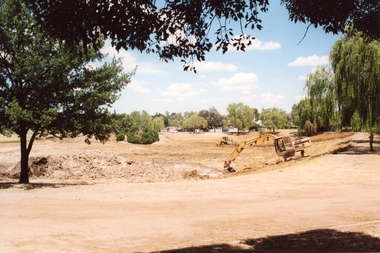 Stawell Historical Society Inc
Photograph, Cato Lake looking from Victoria Street -- Coloured
View of Cato Lake showing the excavation of the lake. Photo taken from Victoria Street, rear of Napier Street residences. The excavation of the lake was to increase its depth and a excavator and bulldozer can be seen working the ground. Willow trees are to the right in the photo.Coloured photograph of the deepening of Cato Lake in c 2002. This view is from Victoria Street, rear of Napier residences. In this photo an excavator is removing dirt with a bulldozer in the background. 5.2.2002 (written in biro).stawell -
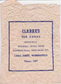 Warrnambool and District Historical Society Inc.
Functional object - Documents, Bag Clarke's Newsagency, Mid 20th century
Names a newsagent who operated in Liebig Street in mid 20th century. G W. ClarkeTypical wrapping paper of the time and provides a list of items typically sold by newsagents at that time.Cream paper bag, with dark blue text inside a rectangular boxCLARKE’S/FOR CARDS/NEWSAGENTS/STATIONERY, BOOKS, GAMES,/SOUVENIRS, MUSIC, PAPER BACKS, ETC./ LIEBIG STREET, WARRNAMBOOL/ Phone: 2407warrnambool, clarke’s, liebig street, stationery, newsagents, clarke gw -
 Ringwood and District Historical Society
Poster, Land Sale Advertisement - Pinemont Estate, Ringwood, Victoria - circa 1924
Map of residential allotments for sale, with terms of sale, summary of subdivision features and local services and facilities, and photographs of local street scene and lake (Loughnan's Lake - location not marked), Subdivision includes Wonga Road (later Loughnan's Road), Glenvale Road, Kubba Road, Felix Crescent, Summit Crescent, Pine Crescent, Aurum Crescent, Hygeia Parade, Panorama Avenue, Avalon Grove, Montalbo Road, Cielterre Avenue. Sole Agents T.M. Burke Pty Ltd, 340 Collins Street Melbourne Phones 6294, 6779. Map by S. Callanan, Licensed Surveyor, 107 Elizabeth Street Melbourne. Date of poster estimated from railway services information extract " ... 36 fast electric trains to Flinders Street daily ... proposed electrification to Croydon ..." . Timeline for electrification of Lilydale Line record indicates Box Hill to Ringwood January 1923, Ringwood to Croydon November 1924 (Source: History of Croydon - McGivern, Vol.1 p20). -
 Port Melbourne Historical & Preservation Society
Functional object - Brick, Auld Reekie Hotel, Rouse Street, Port Melbourne, c. 1850
Obtained from site of demolished hotel, believed to be named 'George Washington' on northwest corner of Nott and Rouse Streets. Believed to have been originally used as ship's ballast.Brick, made at 'Grange near Kirkcaldy', salvaged from demolished hotel, Rouse Street (originally the Auld Reekie Hotel)hotels, auld reekie hotel, george washington hotel -
 Kew Historical Society Inc
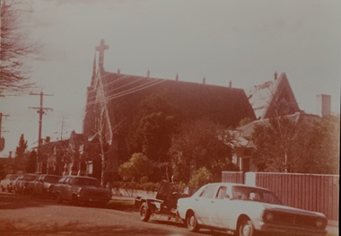
Photograph - Kew Congregational Church, Walpole Street, 1978
The site of the former Kew Congregational Church was the earliest 'built' place of religion in Kew. An earlier building by Charles Vickers was replaced by a new brick church designed by Albert Purchas. Following the creation of the Uniting Church, the church at 30 Walpole Street was declared redundant and demolished to make way for the Bodalla Nursing Home (itself later demolished).Faded colour photograph of the Kew Congregational Church in Walpole Street (Dem. 1978/9). "KH-137 / Former Congregational Church"kew congregational church, architects -- albert purchas, churches -- kew (vic.), walpole street -- kew (vic.), congregational churches -- melbourne (vic.) -
 Port Melbourne Historical & Preservation Society
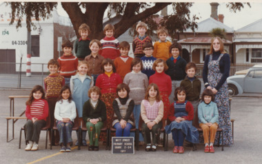
Photograph - Grade 2 - 34 Nott Street Primary School 1977, 1977
The teacher is named as Dawn KABOR & the children identified by their first names only. In the background is shown two Nott Street cottages. Colour photograph with four rows of children & their teacher. The sign in front reads Nott Street Primary School Grade 2 - 34, 1977.On reverse; Teacher Dawn Kabor and the first names of the children.education - primary schools, nott street primary school, dawn kabor -
 Eltham District Historical Society Inc
Photograph, Russell Yeoman, Looking south from Swan Street, Eltham, c,1965, 1965c
... streets ...Train in foreground, Bridge street running parallel to train in background and Brisbane Street obscured by train. Susan Street north of Bridge Street (now Brisbane Street) on left. Vacant block of land is now the site of Bunnings. Presnt day SES building at corner of Susan and Bridge Street can be seen in centre background.The factory in lower left on Brisbane Street is the Sibbel Builders factory of Martin and Herman Sibbel who were ahead of their time with design and prefabricated frames and also built cabinetry in this factory.Digital file only; created from original colour positive slide transparencyeltham, streets, susan street, bridge street, brisbane street, train, bunnings, ses, state emergency service, sibbel builders, martin sibbel, herman sibbel -
 Marysville & District Historical Society
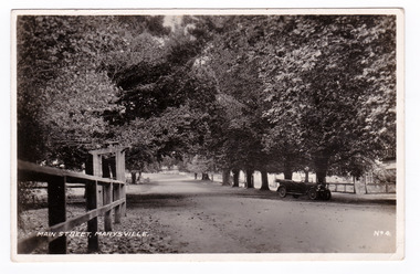
Postcard (item) - Black and white postcard, Valentine Publishing Co. Pty. Ltd, Main Street, Marysville. No.4, 1923-1963
An early black and white photograph of the main street in Marysville in Victoria. An early black and white photograph of the main street in Marysville in Victoria. That street is now known as Murchison Street. This postcard was published by the Valentine Publishing Co. Pty. Ltd. as a souvenir of Marysville.VALENTINE'S/ POST CARD/ FOR CORRESPONDENCE/ FOR ADDRESS ONLY PRINTED IN GREAT BRITAIN The Valentine Publishing Co. Pty. Ltd., Melbourne. Dear Joan Just a card to wish all/ you girls a Merry Xmas/ I hope you all have a good time/ & suppose the Matron will/ throw a Big party/ Yours A Burgess.marysville, victoria, murchison street, postcard, souvenir, valentine publishing co -
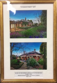 Kew Historical Society Inc
Photograph - Framed Photographs, John & Mary Curtin, 74 Charles Street, Kew, c. 2016
Sir Robert Menzies and his family lived in a number of houses in Kew. He was the local MHR for Kew and for many years Prime Minister of AustraliaTwo colour photographs, mounted in a single gilt frame of the exterior of 74 Charles Street, Kew. During the 1920s, the house was the home of [Sir] Robert and [Dame] Pattie Menzies. The framed photographs were donated by subsequent owners of the property.The annotations to the photographs read: "74 Charles Street Kew / Home of Sir Robert and Dame Pattie Menzies / Early 1920s / Presented by John and Mary Curtin / May 2016".sir robert menzies, dame pattie menzies, 74 charles street (kew) -
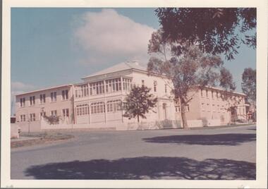 Northern District School of Nursing. Managed by Bendigo Historical Society Inc.
Photograph - Lister House buildings
The Northern District School of Nursing opened in 1950 in to address the issues around nurse recruitment, training and education that had previously been hospital based. The residential school was to provide theoretical and in-house education and practical training over three years. The students would also receive practical hands-on training in the wards of associated hospitals. The Northern District School of Nursing operated from Lister House, Rowan Street, Bendigo. It was the first independent school of nursing in Victoria and continued until it closed in 1989.Colour photograph of NDSN Lister House buildings on Rohan Street, 1960s.ndsn, nursing, lister house facilities -
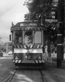 Ballarat Tramway Museum
Photograph - Black & White Photograph/s, Chris Wurr, 1971
Yields information about the stop arrangements at depot junction and the details of one end of a bogie tram.Black and White photograph of No. 42 at the depot junction points. Tram has the Destination 'Gardens via Drummond St Nth'. The points are set for the depot. On the pole adjacent is the tram stop and the street sign for Stafford Court. Shows the detail of the one of the ends of No. 42 and how the trolley rope was positioned by the crews. Stamped on rear in black ink "Donated to BTPS by and Photo By" / "Chris Wurr 12 Truscott Street, Ararat 3377 (053) 52 3403.tramways, trams, depot junction, bogie trams, trolley poles, tram 42 -
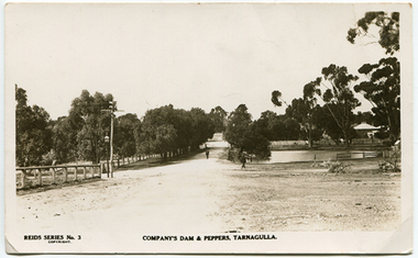 Tarnagulla History Archive
Photo-postcard depicting Company's Dam & Pepper Trees, Tarnagulla, c. 1910
Murray Comrie Collection. Photo taken from near the courthouse in Victoria Street, looking east down King Street. This is an original photo-postcard. Sepia photo-postcard depicting Company's Dam, Tarnagulla and 'Peppers' (row of peppercorn trees at left). Visible at centre is King Street and in the background the the Wesleyan Church. Card is from Reid's Series No. 3.Reverse is printed as standard postcard format (blank/unused). Handwritten on reverse in tiny lettering is 'Mrs. E. Whimpey' probably referring to the person who gave this item to Murray Comrie.tarnagulla, views, dam, water, company's dam, wesleyan church, telegraph -
Clunes Museum
Postcard
The Chapman Lorimer/Nichol and Wallace building is now the home of the Clunes Museum, within "the warehouse" 36 Fraser Street, Clunes. This postcard was printed with an invitation from Clunes Museum for sponsorship.Black and white postcard, image of the Chapman Lorimer/Nichol and Wallace building, 36 Fraser Street,Clunes, circa 1860 chapman lorimer/nichol and wallace, sponsorship, clunes museum -
Whitehorse Historical Society Inc.
Document, Certificate of Title, 1923, 1933
Certificate of Title - Estate of William TilleyCertificate of Title - Estate of William Tilley, Lot 77 Cook Street, Mitcham. Vol 4781, Fol 956069. Rates Enforcement of Charge, 1933Certificate of Title - Estate of William Tilleyland titles, shire of blackburn and mitcham, tilley, william, rates, cook street, mitcham -
 Ringwood and District Historical Society
Flyer, Land Sale Brochure, Heathmont Estate, Vic. - circa 1960
Advertisement for sale of residential lots - Heathmont Estate, opposite Heathmont Railway Station, with map and locality plan.Subdivision includes Canterbury Road, Royal Avenue, Coleman Street, Stoda Street, Herman Street, and Campbell Street. Agent - A.W. Dickson, opposite Station, Ringwood. Phone WU6007. -
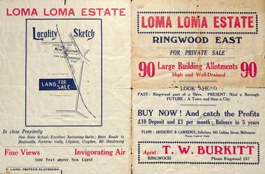 Ringwood and District Historical Society
Flyer, Land Sale Brochure, Loma Loma Estate, Ringwood East, Vic. - circa 1924
Flyer includes extract from "The Sun" 30/10/1924. "Ringwood has been created a Borough with capital value of £680,000. In 1908 there were 173 houses, 8 shops and 720 people. In 1918 the respective figures were 520, 45 and 2,080. For twelve months ended June, 1924, £51,000 worth of Home Sites were sold and £26,000 worth of new buildings were erected. Outward (train) passenger journeys have increased from 94,000 in 1919 to 182,000 in 1923. Train services have been almost doubled and time to Melbourne reduced from 60 to 37 minutes."Bi-fold double-sided land sale advertisement for Loma Loma Estate, Ringwood East, including area map, layout of the estate, and summary of local facilities and services.Subdivision includes Loma Street, Highton Street, Morinda Street, and Station Street (later Railway Avenue) Ringwood East. Agent: T.W. Burkitt, Ringwood, Phone Ringwood 157. -
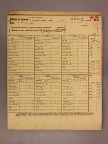 Ringwood and District Historical Society
Administrative record - Rate Books, Borough of Ringwood Valuation & Rate Cards for 1944-49 (Assessments 3193-3197), March 2012
Originally stored at Ringwood Council offices, then taken to PROV.Only source of ratepayers in the Borough of RingwoodDigital imagesFor BR Stewart (Belgrave Road), Violet Sampson (Barkly Street), Margaret Cowin (Barkly Street), Edith Phillips (Barkly Street) & Arthur George (Barkly Street, Allman's Estate). -
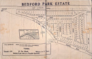 Ringwood and District Historical Society
Plan - Sub-division, Bedford Park Estate, Ringwood, Victoria - 1924
Bedford Park subdivisional development did not eventuate. The land adjoining the railway line became parkland with provision for sporting facilities and the remainder was purchased by the Education Department as the site for Ringwood High School/Secondary College. Poster size land sale advertisement.Subdivision plan includes Bedford Road, Graham Road, Joyce Street, Anderson Street, and Adams Street. Solicitors - W.R.R. Blair, Son & Falconbridge, 405 Collins Street, Melbourne. -
Port Melbourne Historical & Preservation Society
Plan - Evans Street from Ingles Street to Boundary Street, Engineering Department, Town of Port Melbourne, 1893 - 1919
Plan of Evans Street from Ingles Street to Boundary Street Loan no 5 1893.engineering - roads streets lanes and footpaths -
Port Melbourne Historical & Preservation Society
Plan - Pickles Street from Sandridge Road to Spring Street/Tribe Street, Borough of Sandridge, 23 Jul 1880
Plan of Pickles Street, from Sandridge (City) Road to Spring Street/Tribe Street.engineering - roads streets lanes and footpaths -
Port Melbourne Historical & Preservation Society
Plan - Johnson Street from Graham Street to Danks Street, Borough of Port Melbourne, 25 Jul 1890
Plan of Johnson Street, from Graham Street to Danks Street. (including Drainage Sections)Michael Minahan (?) Contractor, 25-7-1890engineering - roads streets lanes and footpaths, michael minahan -
Clunes Museum
Negative - FILM NEGATIVE
FOUR NEGATIVES OF CLUNES STREET SCAPE FRASER STREET - TAKEN FROM TEMPLETON STREETfraser street, film negatives -
 Ballarat Heritage Services
Photograph, Clare Gervasoni, House in South Street, Ballarat, 2020, 13/04/2020
Colour photograph of a house in South Street Street, Ballarat, near the intersection of Skipton Street .ballarat, south street, cast iron