Showing 1810 items matching " yarra park"
-
 Melbourne Tram Museum
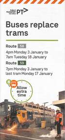
Pamphlet, Yarra Trams, Buses Replace Trams - Routes 58, 59, 86 and 96, 2022
.1 - pamphlet provided at tram stops giving details of the works and bus services for routes 58 and 59 .2 - Project document describing the work and dates - downloaded from the Yarra Trams website after buses were used to replace route 58 from the Royal Children's Hospital rather than from Royal Park Station as originally planned. .3 - as for .1 - for the upgrading of the Merri Creek Bridge - route 86 - see also Reg Item 6066 .4 - as for .1 - for the installation of superstops in Nicholson St between Elgin St and Holden St - route 96Shows the methods that Yarra Trams customers are advised of changes due to track replacement works..1 - Pamphlet - DL, four fold printed on off white paper titled - Buses Replace Trams - Route 58 and Route 59 - Jan 2022 .2 - Project sheet - 3 A4 sheets, titled "Renewal works: Essendon Depot and Mt Alexander Road - 3.1 to 18.1.2022. .3 - Pamphlet - DL 3 fold, Buses Replace Trams, route 86, November 2021 - Merrit Creek Bridge works .4 - Pamphlet - DL - 4 fold, Buses Replace Trams, route 96, January 2020 - Nicholson St works for tram super stops.mt alexander road, tram works, track work, route 58, route 59, yarra trams, ptv, essendon tram depot, route 86, route 96, nicholson st, merri creek, bridges, carlton, super stops, trams, tramways, northcote -
 Emerald Museum & Nobelius Heritage Park
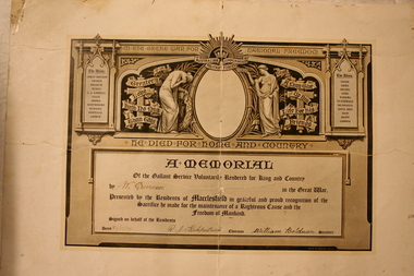
Memorial Certificate
World War 1 Memorial certificate in memory of William Eric Durance -
 Emerald Museum & Nobelius Heritage Park
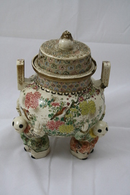
Incense Burner, Early 19th century
Nancy Hawley requested one of a pair come to the Emerald Museum . It was brought back from Japan by a friend of Noni Smith after World War 2. Noni Smith was Mr Murphy's nurse for many years Noni died at the age of 90 years . She was principal of Emerald Primary School. She was very involved with the recovery after Ash Wednesday 1983 firesJapanese Incense Burner Circa early 19th centuryFloral Bowl with Figured Legs and Topjapanese insense burner -
 Emerald Museum & Nobelius Heritage Park
Registered Letters Received, Menzies Creek Post Office 1887 to 1926, late 19th century
The book is primarily historically and socially significant for understanding the local community as it lists all the registered letters received at the Menzies Creek Post office. Also gives some insight into the local families.Brown hard cover book with red leather binding on the spineRegistered Letters Received, Pat Ehenholm 6 Menzies Rd Menzies Creek, spine repaired with brown packaging tape. Grandma Wall had Post-Office 1907 to June 1926 (after last entry)post office, menzies creek, mail, registered letters -
 Emerald Museum & Nobelius Heritage Park
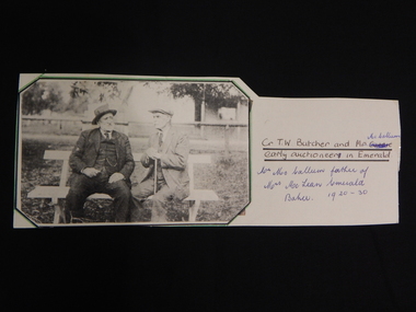
B/W Photograph, 1920 - 1930
Cr. T.W. Butcher and Mr. McCallum (Early Auctioneer in Emerald). Mr. McCallum is the father of Mrs. McLean, Emerald. Photograph attached to cardboard mount. early auctioneer, emerald, cr. t.w. butcher, mr. mccallum, mrs. mclean -
 Emerald Museum & Nobelius Heritage Park
B/W Photograph, Holman Family
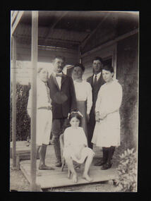
The Holman family ran the Guest House near The Falls, Beaconsfield. Left to Right: John Basil Holman, Bostraze Holman (father),front seated Barbara Molesworth Holman, Ellen Molesworth Holman (mother), Derrick Hewlett Holman, Mary Joyce Holman. Photo taken at Bamawm c.1921?holman, guest house, the falls, beaconsfield -
 Emerald Museum & Nobelius Heritage Park
Horse Bits
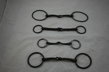
VEMU1615.1 The 2 rings are elongated horizontally and have an axial length of 11cm. The shanks are 10cm long. VEMU1615.2 The rings are 8.7cm diameter, and the shanks are 9.7cm long. VEMU1615.3 The rings are 6.3cm diameter, one ring is circular and the second has a pointed end. The is 12cm long. VEMU1615.4 The rings are 6.2cm diameter, and the shanks 8.4cm long. -
 Emerald Museum & Nobelius Heritage Park
Snaffle Bit with Mouthing Keys
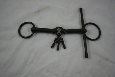
Custom made iron snaffle bit with mouthing keys used for breaking in young horses. The horse played with the keys, so that it would end up with a soft mouth. The side bar would help to hold the bit in the mouth. Normally there would be two side bars. The bit is double jointed with a circle in the middle (3.5cm diameter). Hanging from the circle is an oval plate supporting 3 mouthing keys (3.5cm long). The external rings on the bit are 6.5cm diameter with a 19.4cm vertical bar attached to the inner edge of the ring on the right hand side. -
 Emerald Museum & Nobelius Heritage Park
Stock Whip, Late 1800's
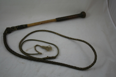
Belonged to Trevor Pearce's grandfather, who had dairy farms at Kilsyth, and later at Montrose. He abandoned cattle for growing vegetables. This was in 1946Cane handle, plaited leather grip with plaited knob. The leather plaited whip is attached to the handle with oiled twine. The end tip of the whip (cracker) has a leather thong finishing in plaited twine. -
 Emerald Museum & Nobelius Heritage Park
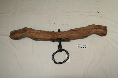
Bullock Yoke, Late 1800's
Part of bullock harness. Wooden yoke with 4 holes for the bows, and 3 for the centre metal ring supported by a metal plate bolted into the wooden yoke. -
 Emerald Museum & Nobelius Heritage Park
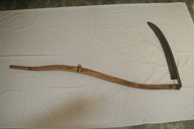
Hand-Scythe- (right handed), Mid 1800's
Long curved wooden shaft with a wooden grip attached at right angles via a steel U-bolt. The long steel curved blade is fitted perpendicular to the wooden shaft and it projects towards the left hand side of the shaft. The blade has a groove that goes into a U-bolt which tightens it onto the shaft. -
 Emerald Museum & Nobelius Heritage Park
Sure Grip Wire Strainer (long chain is missing), 1917 - 1953
The wire strainer was commonly used on Australian farming properties for putting fences up. Sure Grip Wire Strainers were advertised in Australia from 1917 to 1953. The distinctive grips were patented in Britain in 1913 (William Swann, (spring, hook and chain manufacturer, Walsall,in England).Improvements in or relating to means for gripping wire or the like: British patent 24,520/13. 29 October 1913.Steel bar with 2 interlocking grips for fastening the wire.Corroded marking about halfway along the lever. wire strainer -
 Emerald Museum & Nobelius Heritage Park
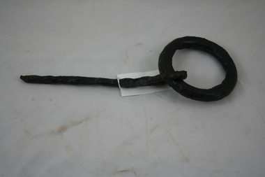
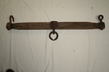
Ring and Pin for Bullock Yoke
Iron pin 24.5cm long, attached to an iron ring of 12cm diameter, via an ovoid shaped hole in the pin. -
 Emerald Museum & Nobelius Heritage Park
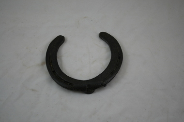
Large Horse shoe for cart horse
Eight hole horse shoe with 5 nails attached. -
 Emerald Museum & Nobelius Heritage Park
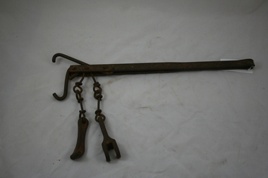
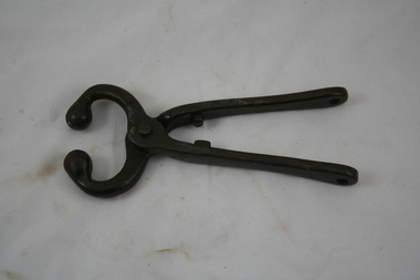
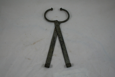
Pincers for leading large animal by the nose
Tool made of two pieces of metal with blunt concave jaws that are arranged like the blades of scissors, used for gripping and pulling things. Iron handles 15cm long, with hole cut into the gripping end. The pincers have round, spherical ends for inserting into the nostrils. -
 Emerald Museum & Nobelius Heritage Park
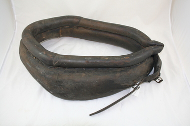
Horse Collar
A horse collar is a part of a horse harness that is used to distribute the load around a horse's neck and shoulders when pulling a wagon or plough. The collar often supports and pads a pair of curved metal or wood pieces, called hames, to which the traces of the harness are attached.The horse collar is oval, rather than circular and it is not very flexible. It is padded with a straw- like fibre and the shape conforms to the shape of the horse's body. A strap and buckle is attached to adjust to the horses' neck and shoulders. The other buckle on the opposite side of the collar has no complementary strap to attach to it. -
 Emerald Museum & Nobelius Heritage Park
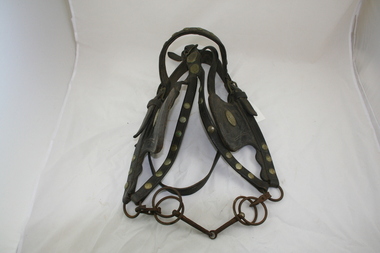
Full Bridle for Driving Horse
Found in the roof space at Three Springs, Clematis with various bridles, harness, reins and collars. They came from under the original post office at "Holly Tree Inn", Olinda.Ornate Leather Bridle made by J.Kelly, St. Kilda and Melbourne. It has blinkers, snaffle bit and a throat strap. Brass studs decorate the leather straps and the leather blinkers each have J. Kelly's brass plates attached.J. Kelly, St. Kilda, Melbourne. -
 Emerald Museum & Nobelius Heritage Park
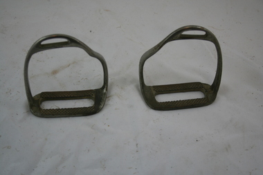
Riding Stirrups
The pair of stirrups have a light steel frame that holds the feet of a rider. . -
 Emerald Museum & Nobelius Heritage Park
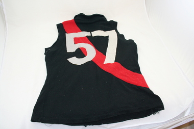
Emerald Football Jumper, 1950's
Worn by Mick Anzin, during the 1981 winning Grand Final.Machine knitted, sleeveless jumper, with a red diagonal strip extending from the left shoulder to the right hip. The stripe is on both the front and back of the jumper. The number 57 is on the back. "57" -
 Emerald Museum & Nobelius Heritage Park
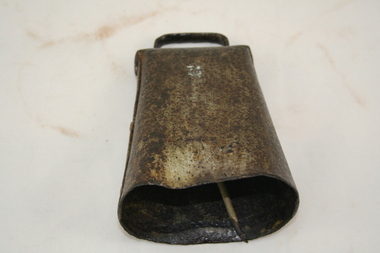
Cow Bell
Iron bell and clapper. The bell is a trapezoid shape of thin, flattened sheet metal with an attached thin metal handle. The clapper is like a thin match stick. -
 Emerald Museum & Nobelius Heritage Park
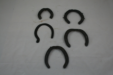
Horse-Shoes
George Walter A'Vard was a bullocky who worked all through the Dandenongs from 1900 to 1928, where he sold his bullocks. He settled in Emerald in 1920.VEMU1613.1 Eight holes and 7 nails. 13.5cm (H); 12.8cm (W); 4mm (D). VEMU1613.2 Eight holes. 14cm (H); 10.8cm (W); 3mm (D). VEMU1613.3 Six holes. 10cm (H); 9.5cm (W); 6mm (D). VEMU1613.4 Five nails. 12.5cm (H); 12.1cm (W); 7mm (D). VEMU1613.5 Five holes, 1 nail. 13cm (H); 11.5cm (W); 2mm (D). -
 Emerald Museum & Nobelius Heritage Park
Whippletree, Pre WW2
The whippletree consists of a loose horizontal bar between the draught animal and its load. The centre of the bar is connected to the load, and the traces, chains or straps on each side of the harness, attached to its ends. Whippletrees are used when pulling a dragged load such as a plough, harrow, or log. The whipple tree was attached to a scoop, which was used for building the 'Puffing Billy' railway and also for scooping out Emerald Lake.Wooden bar with metal hook at each end and a metal ring attached to the centre. -
 Emerald Museum & Nobelius Heritage Park
Photographic Printing Frame
Used to make paper photgraphic prints from negatives.VEMU1631.1 Wooden framed photographic printing frame with glass plate and wooden backing, held together with flat brass springs. VEMU1631.2 Wooden framed photographic printing frame with glass plate and wooden backing, held together with flat brass springs.VEMU1631.1 Eastman Kodak Co, Rochester, N.Y. made in USA, for 4 x 6 plates. VEMU 1631.2 Eastman Printing frame for 4 x 6 negatives, Eastman Kodak Co., Roch -
 Emerald Museum & Nobelius Heritage Park
Large Animal Pincers
Used for leading bullocks, by the nose.Wrought iron. Long handles with rolled over metal at the end. -
 Emerald Museum & Nobelius Heritage Park
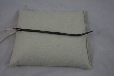
Hession Bag Needle
Used for sewing hession bags eg. potato sacks.Steel Needle -
 Emerald Museum & Nobelius Heritage Park
Cow Bell
Trapezoidal shape, narrower at the top. Folded sheet metal housing with attached handle. The clapper is a folded strip of metal attached to a wire hanger, by a bolt. -
 Emerald Museum & Nobelius Heritage Park
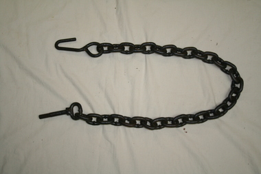
Short Chain, 1920's
Used before tractors came in. It was a horse drawn implement.Short chain with hook on one end and screw on the other end. -
 Emerald Museum & Nobelius Heritage Park
Ruby Ware
Part of Silver Wells, Gembrook collection.VEMU1629.1 Ruby Ware Jug. Ruby colour top and clear cut glass base. Broken handle. Gold writing 'Dear Mother from Lucy 1907'. VEMU 1629.2 Ruby Ware Small Dish/Bowl. Ruby colour top band and clear cut glass base. VEMU1629.3 Ruby Ware Vase. Ruby colour with entwined leaf pattern around side. Turned edge at top.VEMU 1629.1 Gold writing 'Dear Mother from Lucy 1907'.silver-wells; ruby-ware. -
 Emerald Museum & Nobelius Heritage Park
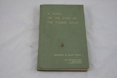
Book, A Guide to the Care of the Young Child, Department of Health, 1968
Emerald Infant Welfare Centre. Green rectangular book, with gold embossed writing on cover.A Guide to the Health of the Young Child, Department of Health Victoria, 6th edition. Vera Scantlebury Brown, Kate Campbell, A. Elizabeth Wilmotemerald-infant-welfare-centre; department of health victoria; vera-scantlebury-brown, kate-campbell, a. -elizabeth-wilmot. -
 Emerald Museum & Nobelius Heritage Park
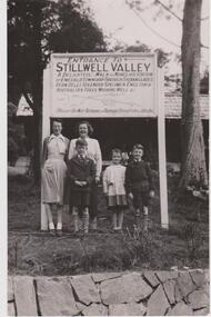
Photograph Stillwell Family, 1953
Entrance to Stillwell Valley (at edge of Emerald Lake). Graham and Helen Stillwell (now Swaine) with Aunt Gwen Stillwell and friends. Grandfather, Bertie Stillwell opened Emerald Lake in 1941.Bertie Stillwell was a Councillor with Fern Tree Gully Council. Stillwell's Deviation is located off Avons Rd, Avonsleigh.Black & White photograph. stillwell-valley; bertie-stillwell; emerald-lake-park; helen-swaine;