Showing 19894 items
matching east-malvern
-
 Ringwood and District Historical Society
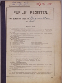
Administrative record, Ringwood East State School No 4180-Pupil Register (Book 2 of 15). Jan 1934 - Dec 1946 . Registration Numbers 367 to 730
Ringwood East State School No 4180-Pupil Register Images. A searchable transcript of all these images can be found as a pdf in VC Record 7509. Note: For a high resolution copy of one or more images, contact Ringwood and District Historical Society (RDHS). The original Registers are held at Public Records Victoria (PROV). Scanning of these was commissioned by RDHS and undertaken by Mark Grealy, Archival Access in 2013. (https://www.archivalaccessvictoria.com/). The registers were transcribed in 2021-2022 by Sue Breese, Archivist at RDHS. -
 Orbost & District Historical Society
plan, before 1948
Drainage infrastructure was developed and maintained in this region by the Snowy River Improvement Trust. The Trust was administered by a local committee and its activities funded by a local rate charged on the farmers and land owners in the Trust’s designated district. The level of the rate charged by the Trust was designed to be proportionate to the benefit derived from the works undertaken. Financial assistance was provided by the State Government from time to time for specific projects such as post flood repairs but not for new capital works. The Trust undertook new drainage and river management works including tree planting, rock beach construction and servicing of the drains and flood gates. The Trust also provided a personal flood warning service to the farmers in its district. The Trust ceased to operate in 1997 with the advent of the East Gippsland Catchment Management Authority. The infrastructure developed by the Trust continues to provide a service to the farmers in the region. (ref. 4 East Gippsland CMA Submission to Inquiry into Flood Mitigation Infrastructure in Victoria) This plan is significant as a historical document. The Snowy River Improvement Trust was vital to the Orbost district because of its ability to apply local knowledge and to engage the local farming community.A large plan of divisions of land for the purpose of levying the Snowy River Improvement District - Bete Bolong, Orbost, Waygara, Newmerella and Orbost East. The properties are coloured according to levy amount. The scale is 1" - 20 chains. snowy-river-improvement-trust -
 Greensborough Historical Society
Photograph - Digital Image, Cherel Sartori, Looking east from Henry Street to the river 1956, 01/01/1956
Looking from Henry Street east to the Plenty River, 1956. The house was built 1917, at 112 Henry Street Greensborough by William Mitchell on the 60 acre dairy farm owned by Ethel and Walter Kell. This collection of photographs was copied by Cherel Sartori (who owned the house from 1990-2000), following a visit by Claude Amiet who lived in the house as a child in the early 20th century.An indication of the rural aspect of this area in the mid-20th century.Digital copy of black and white photographkell's cottage, claude amiet, cherel sartori -
 Stawell Historical Society Inc
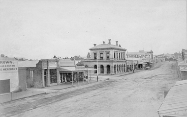
Photograph, Main Street Stawell looking East with the large two story building being the Post Office 1878
Main St. looking East. Large two story building is the Post Office. 1878. Star Hotel in middle of road on the hill. Buildings from left Brown Produce Merchant, McAlpine Bros Tinsmith Plumbers, J. Porch Draper, Chemist, Stawell Post Office, Akins Seedsman Stationer, Grocer, Herbert Photo Studio's, T. Browns Timber Yard, Star Hotel. Victorian Views. C. Herbert, Photo. Stawell 1878stawell businesses streetscape -
 Melbourne Tram Museum
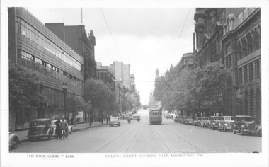
Postcard, Rose Stereograph Co, "Collins Street looking east, Melbourne", late 1940s
Rose Series postcard No. P 2618, titled "Collins Street looking east, Melbourne", Photo shows W2 class tram 543 about to arrive at its Collins and Spencer Streets destination. The return destination has been reset to Kew route 42. Another W2 is in the far distance. The McPherson’s Pty Ltd. building on the left was built 1934-37. Photo late 1940sYields information about the west end of Collins St late 1940s.Postcard - printed real photograph with Rose Stereograph Co. name on the rear.tramways, trams, collins st, w2 class, tram 543, route 42 -
 Lakes Entrance Regional Historical Society (operating as Lakes Entrance History Centre & Museum)
Album, 1990 c
A4 album of twelve black and white photographs taken during East Gippsland Bullock League activities in East Gippsland Victoriatownship, volunteering -
 Bendigo Military Museum
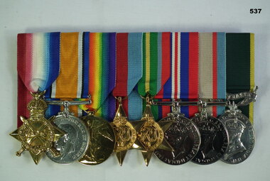
Award - MEDAL SET, Post WW1, Post WW11
Frederick George East. WWI Service , " Royal Army Mecial Corp", British. WW2 Service. Enlisted in the AIF on 13.10.41. Part of "Sparrow Force” he was a POW. On discharge from the AIF 10.12.45 he was a Capt serving in the Australian Intelligence Corps. Refer 516.7, 517, 538.2.Medals, set of (8) court mounted Re F.G. East . "ED" 1.1914 -1915 Star. 2.British War Medal 1914-19. 3. Victory Medal. 4.1939-45 Star. 5, Pacific Star. 6. War medal 1939-45. 7. Australia Service Medal. 8. Efficiency Medal.Medals 1,2,3 - "56520, CPL F.G.East R.A.M.C" Medals 4,5,6,7 - "VX64901 , F.G. East" Medal 8 - "VX64901 Capt. F.G. East"numismatics - military medals, british - australian -
 Ringwood and District Historical Society
Photograph, "Johnswood" - Home of Charles Wedge, Eastfield Road, East Ringwood - 1964 (demolished in 1967). Charles Wedge was a relative of John Helder Wedge, Batman's surveyor
Written on backing sheet of one photo: " 'Johnswood', Home of Jack Wedge, Pres. of old Ringwood East Progress Association. Related to John Helder Wedge, Batman's surveyor.1964" On another "Home of CHarles Edward Lyndhurst WEDGE Died 1962". Demolished 1967 On another "Old Charles Wedge Home. Eastfield Rd. Sold to G.Havers" -
 Coal Creek Community Park & Museum
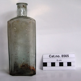
Bottle, glass, W. A. Stokes, Chemist
TROVE : Jewish Herald (Vic. : 1879 - 1920) Friday 14 March 1913 p 10 Advertising. Mr. Frank Newman desires to intimate that he has purchased the old-established business of the late MR. W. A. STOKES, recently carried on by Mr. P. J. Winch, and hopes by giving; his personal attention to the Pharmacy to merit your support. 181 CARLISLE ST.. BALACLAVA. Tel. Windsor 30. TROVE : The Age (Melbourne, Vic. : 1854 - 1954) Tuesday 13 December 1887 p 5 Article " ROUGH ON RATS" POISON.' . PROSECUTION UNDER THE POISONS ACT. At the St. Kilda police court, on Friday, W, A. Stokes, chemist, Carlisle-street, Balaclava, was prosecuted under the Poisons Statute on the charge of selling to one Mrs. Hannah Charlton a poison without having made and signed the entry required by the act. A second charge of selling to Mrs, Hannah Charlton a poison without having obtained the signature of the purchaser to an entry as required by the act was also preferred against the defendant. Both cases were taken together. Mr, Donovan appeared to prosecute, and Mr. Cole for the defence. Senior-constable Connell deposed that he knew the defendant. On the 24th of October last an inquest was held at East St. Kilda relative to the cause of the death of a man named Charlton. A packet bearing the label " Rough on Rats," which was found. in the deceased's bedroom, was produced at the inqiry, and afterwards handed over to Mr. Blackett, Government analytical chemist for analysis. The verdict of the jury was that the deceased died from the effects of arsenical poisoning. Hannah Charlton, a widow, residing in South Yarra, said in September last she purchased a packet of "Rough on Rats" from the defendant's assistant. Witness was not asked her name, place of abode, occupation or for what purpose the poison was required; neither did she observe the assistant make any entry in a book, She did not attach her signature to any document, and was not asked to do so. The packet was purchased for the purpose of poisoning rats. Cuthbert Robert Blackett, Government analytical chemist, stated that Constable Ballantyne handed him the packet produced. Witness made an analysis of the contents, and found it composed of arsenic, slightly coloured with a carbonaceous matter. The mayor announced that there was a doubt in the minds of the magistrates as to whether the defendant could be held guilty under the law, but they thought the prosecution had attained its object by making known the fact that "Rough on Rats" is a poison. They thought that such preparations should be entered by the sellers, but in that case they were inclined to give the defendant the benefit of the doubt and dismiss the case.Rectangular clear light green tinted glass bottle with embossed text and numerals on side and base.'W. A. STOKES CHEMIST EAST ST.KILDA' on side. 'K6232' on base.chemist, poison, arsenic -
Ballarat Heritage Services
digital copy, Ballarat East high School Magazine 1959, 1959
Ballarat East High School was established in the early 1950s. This is one of the earliest magazines produced. School History: In February, 1955, Ballarat East High School opened in Hopetoun Street, in the vacated weatherboard buildings of the Girls’ Secondary School. In 1956, however, the School moved to its present site in Fussell Street, but because of the lack of space, Woodwork and Cookery classes were still held at Hopetoun Street. Since then there has been steady progress. The original building was extended, more classrooms and a library being built. A Domestic Science block was completed in 1957. Later, as mentioned elsewhere, sheltersheds, basketball courts, a bidycle shed and a canteen were provided for the pupils from funds raised by the Parents’ Association. Where there were previously bare areas of clayey soil we now have asphalt paths and neat gardens. Shrubs were planted, and seats, painted in the School colours, were places around the asphalted areas. (Page 5, 1959 BEHS School Magazine) 3 pdf files holding multiple pages of 1959 School Magazinebehs, ballarat east high school, ballarat east, magazine, 1959 -
Ringwood and District Historical Society
Document, et al, Notes of Heathmont History extracted from Place of Many Eagles (Russ Haines c2006), plus History of Land on which Heathmont East Primary School Built (Mervyn Chivers 1985), 2006
A4 document "Notes on Heathmont" in two parts: - Heathmonth History notes extracted by Russ Haines from Place of Many Eagles c2006 - Taxt of talk "A History of the Land on which Heathmont East Primary School is Built" by Mervyn Chivers, 1985 Also brief Notes: - Heathmont Progress League 1926 - Deplorable state of Canterbury Rd July 1928 - Letter from Ada Marden 16th May 1973 pdf Version loaded to VC. Original Word Document help in RDHS Archives -
 Melbourne Tram Museum
Postcard, Biscay Greetings, Collins St east of Russell St, mid 1970's
Colour postcard divided back - Biscay Greetings, of an photo looking west along Collins St east of Russell St with SW5 730 on a route 42 westbound. Has the Town Hall and National Mutual building in the background. Back has space for name and address, stamp and a message and details of the postcard. Produced by Biscay Greetings, possibly mid 1970's. Card No. BG119 has serrated edges. 2637.1 - same photograph, different publisher - "scanscene international" photo by R Bell. - From the Keith Kings Collection.trams, tramways, postcards, collins st, w5 class, tram 730 -
 Melbourne Tram Museum
Document - Report, Professor E. W. Russell, "On the right track .. Freeways of Better Public Transport for Melbourne's East?", Jul. 1991
Report - 120 pages + cover perfect bound - titled "On the right track .. Freeways of Better Public Transport for Melbourne's East?", to the Victorian Minister for Transport Hon. Peter Spyker by Professor E. W. Russell, dated July 1991. Has a table of contents. Report looks at the options for transport to the Doncaster area, freeways, light rail or tram or heavy rail, considers options for the extension of routes 48 and 72 (along Burke Road), buses, tram line from Shoppingtown to Box Hill. Includes illustrations and maps.trams, tramways, public transport, doncaster, box hill, new tramway, route 48, route 72 -
 Melbourne Tram Museum
Photograph - Digital Image, Kevin O'Reilly, Royal Park looking east over the Royal Park Hospital, mid 1920's
Image from CD (Compact Diskette for use in computers) - see Reg Item 135. Image titled "Royal Park 2" on CD, of looking east over the Royal Park Hospital in the north west corner of the Royal Park itself. Has the West Coburg tram line in the photograph in the top quarter. The Royal Park railway station and cutting can be seen in the top right hand corner of the photograph. Possibly late 1920's given the construction of the Royal Park tram line was completed through the park in 1925.trams, tramways, royal park, west coburg -
 Eltham District Historical Society Inc
Photograph, Grade IIB, possibly Yarra Park State School No. 1406, East Melbourne, c.1930s
Unidentified school and students (not Eltham State School No. 209). Possibly Yarra Park State School No. 1406 (similar brickwork in backdrop to other photos (1928) in collection of a family that moved to Research. Yarra Park State School No.1406 (also known as Yarra Mews) was located at 1055 Punt Road, East Melbourne. It was built 1874 - 1877. Its current use is residential appartments. It is listed in the Victorian Heritage Database. Reproduction colour print of black and white printyarra park state school no. 1406, schools, yarra park, yarra mews, class photo, east melbourne, state school no. 1406 -
 Orbost & District Historical Society
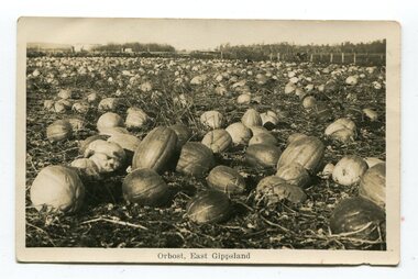
black and white photograph / postcard, first half 20th century
Pumpkins were grown widely on Orbost farms and used to feed pigsThis photograph is associated with pumpkin growing in Orbost.A black / white photograph / postcard of a paddock of pumpkins.on front- at bottom - "Orbost, East Gippsland"orbost-agriculture pumpkins-orbost -
 Whitehorse Historical Society Inc.
Clothing - Tee Shirt, c. 1985
See Ref. No. NA4362Maroon child's school tee shirt. Short sleeves and round neck. White motif on front with 'Blackburn East' in a scroll beneath 'rising sun' Emblen.Blackburn Eastcostume, children's uniform -
 Whitehorse Historical Society Inc.
Photograph, Whitehorse Historical Society, 2011
3 coloured photographs taken at a display of the 150th anniversary of the Burwood East Primary School, corner Blackburn and Highbury Roads, East Burwood.whitehorse historical society, displays -
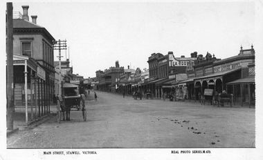 Stawell Historical Society Inc
Photograph, Main Street Stawell looking East with the Post Office on left & the Post Office Hotel on the right
Main Street Stawell looking East. Post Office on left, double story building. Note Post Office Hotel Rowland's as previously E. J. Copley . Real Photo Series M 673 1922. Six horse drawn carts along the street and people moving around the shops. Also the telegraph poles in this photo have 4 cross timber beams on the previous photo they only had 3 cross timber beams. Sepia photo of Main Street, Stawell c 1920's. The street scene show the commercial businesses of the time with horse and carts being the main form of transport.Main Street, Stawell. Victoria. Real Phot Series. M.673. Printed on the back "Published by the Valentine & Sons Publishing Co. Ltd. Melbourne Sydney & Brisbane.stawell streetscape -
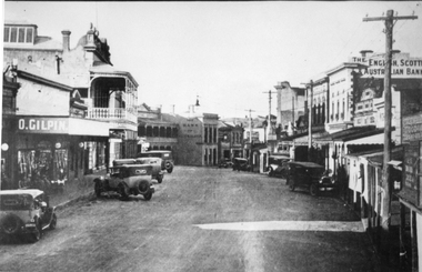 Stawell Historical Society Inc
Photograph, Upper Main Street Stawell looking East 1930
Upper Main Street looking East c 1930. Two Story shop on left behind O. Gilpin is Chadwicks Draper later partially destroyed by fire. Some buildings not visible, Commercial Hotel then Oriental Bank / The Bank Australasia in Centre of Photo, Punchard's Furniture. On right of street, side of Mechanics institute, B.S. Dawson Chemists & R.H. Wadsworth Watchmaker, the English Scottish & Australian Bank on right. Clark & Scott Drapery. stawell streetscape -
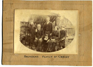 Orbost & District Historical Society
black and white photograph, C1888 -1889
This is a photograph of the Saunders Family at Orbost 1888-89. It is Arthur and Agnes Saunders with their children, Beatrice, Cyril, Hilda and Vera. Arthur Scott Saunders was born 1864 in Orbost and died 3.12.1913 in Orbost where he is buried. He was the son of Son of Thomas Frederick Saunders and Lucy Beard Scott. He was a storekeeper at Orbost, a member of the early Show Committees, a Rechabite in 1893, and was a member of the Board of Guardians of the Church of England from 1894 to 1913 where he served as secretary and treasurer of the Board. His wife was Agnes Louisa Stuart Morriss who was born in 1862 and died 26-11-1938 at East Malvern and is buried in . Orbost cemetery. She sold the business in 1919 to Mr J. H, V. Dale. She left Orbost with her two daughters for East Malvern in April 1927. Saunders General Store was opened in 1900, overlapping part of the present Mensland and Coultons. The ―Melbourne Store‖ refers to it being a branch of their Melbourne store. The shop was burnt down in the early 1930‘s. ( info. from Saunders Family Newsletter by John Phillips)This is a pictorial record of a prominent early Orbost family and is a useful research item.A black / white photograph of a family group with the parents seated and their children standing around them. In the background is a wooden fence. It is on a beige coloured buff card.on front - "Saunders family at Orbost" on back - " Saunders family at orbost, 1888 - 1889"saunders-orbost -
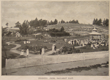 Ballarat Heritage Services
Photograph - Image - Black and White, Pearce's Park, Ballarat East, 1915, 1915
Pearce's Park is situated on the corner of Barkly and Gladstone Streets, Mount Pleasant (although it is sometimes described as being in Golden Point and Ballarat East). Isaiah Pearce was an owner of a goldmine and mayor. He built Clowance House in Barkly Street and chose not to build around Lake Wendouree as he thought it was snobbish. Since Pearce's death, the home has been a maternity hospital and a women’s boarding house. It includes a marble-effect entrance, fireplaces, ceilings and cornices. Photograph of Pearce's Park in Mount Pleasant.ballarat east, pearce's park, mount pleasant -
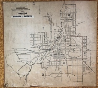 Ballarat Tramway Museum
Map, General Accident Fire and Life Assurance, "Sketch Map of Ballaarat including Ballaarat East and Sebastopol", c1940
Yields information about Ballarat c1940 and how the area was rate for insurance purposes.Map - paper mounted onto a heavy card backing titled "Sketch Map of Ballaarat including Ballaarat East and Sebastopol" with a printed label "General Accident Fire and Life Assurance" pasted to the top of the title. Drawn at 30chains to the inch. Map shows the boundaries between the carious insurance classifications in the district, which relates partly to the local government areas at the time. Shows the Yarrowee, Gong Gong Creeks, rail lines, stations, Black Hill and some other features. Includes the Explosives factory area. Does not show the tram lines.trams, tramways, ballarat, maps, insurance, sebastopol -
 Kew Historical Society Inc
Plan - Subdivision Plan, Normanby Estate, East Kew, 1913
Pru Sanderson, in her groundbreaking ‘City of Kew Urban Conservation Study : Volume 2 - Development History’ (1988), summarised the periods of urban development and subdivisions of land in Kew. The periods that she identified included 1845-1880, 1880-1893, 1893-1921, 1921-1933, 1933-1943, and Post-War Development. These periods were selected as they represented periods of rapid growth or decline in urban development. An obvious starting point for Sanderson’s groupings involved population growth and the associated economic cycles. These cycles also highlighted urban expansion onto land that was predominantly rural, although in other cases it represented the decline and breakup of large estates. A number of the plans in the Kew Historical Society’s collection can also be found in other collections, such as those of the State Library of Victoria and the Boroondara Library Service. A number are however unique to the collection.The Kew Historical Society collection includes almost 100 subdivision plans pertaining to suburbs of the City of Melbourne. Most of these are of Kew, Kew East or Studley Park, although a smaller number are plans of Camberwell, Deepdene, Balwyn and Hawthorn. It is believed that the majority of the plans were gifted to the Society by persons connected with the real estate firm - J. R. Mathers and McMillan, 136 Cotham Road, Kew. The Plans in the collection are rarely in pristine form, being working plans on which the agent would write notes and record lots sold and the prices of these. The subdivision plans are historically significant examples of the growth of urban Melbourne from the beginning of the 20th Century up until the 1980s. A number of the plans are double-sided and often include a photograph on the reverse. The Normanby Estate, which was adjacent to Normanby Road, Kew East, included thirty-one lots for sale. Streets on the subdivision plan include Adeney Avenue, Park Hill Road, Normanby Road, Weir Street and Wharton Street. Cotham Road and its tramway are shown nearby. The plan is interesting as it shows Wharton Street, named after the architect and town planner George Wharton, who was the first chairman of the Municipality of Kew. The street was to later be renamed Cecil Street. Also shown are proposed ‘Municipal Gardens’ where Parkhill Drive is now located.subdivision plans - kew, normanby estate -
 Melbourne Tram Museum
Ephemera - Timetable, Melbourne & Metropolitan Tramways Board (MMTB), Doncaster Rd (Depot) - via Middleborough Rd - Box Hill - East Kew bus route, c1969
Timetable - listing the various runs, times at various timing point or locations for Doncaster Rd (Depot) - via Middleborough Rd - Box Hill - East Kew bus route, weekdays Index sheet 81 and Footscray depot - Saturday printed on yellow paper, Deer Park - Sunshine Park - Sunshine - Footscray - City index sheet 35, four pages. Each sheet has been taped on the rear for storage and hole punched. On the rear of each sheet (all the same) details of the route, time points. Front and back sheets scanned.trams, tramways, mmtb, timetables, doncaster depot, footscray, box hill -
 Melbourne Tram Museum
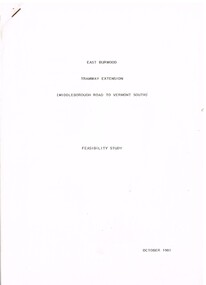
Document - Report, Melbourne & Metropolitan Tramways Board (MMTB)?, Ministry of Transport?, "East Burwood Tramway Extension - Middleborough Road to Vermont South - Feasibility Study, Oct. 1981
Report - 43 pages, photocopied, stapled in top left hand corner - titled "East Burwood Tramway Extension - Middleborough Road to Vermon South - Feasibility Study - October 1981". No details as who made the report, assumed Ministry of Transport or MMTB. Gives details of proposals considered, population and land use, existing services, patronage, operating costs, revenue and provides an assessment. Looks at costs for an extension only to Blackburn Road, Springvale Road and to Vermont South. Report showed the cost benefit ratio for Blackburn Road was 1, and less for the other possibilities.trams, tramways, east burwood, feasibility study, new tramway, mmtb, middleborough rd, vermont south -
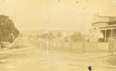 Ringwood and District Historical Society
Photograph, Bedford Rd / Bayswater Rd. looking east from Warrandyte Rd. railway underpass, c1910
Dirt Road with houses and planter boxes for street trees on one side.Multiple copies of photos SS0078 and SS0079 - Backing sheet on one reads "Bedford Rd. looking east from Warrandyte Rd. railway underpass, c1910". Others have Bayswater Rd, Bedford Rd etc names. Some copies state "Ringwood House on Right". There is a also a postcard version. SS0079rev is an image of the postcard reverse, dated feb 24 1910 -
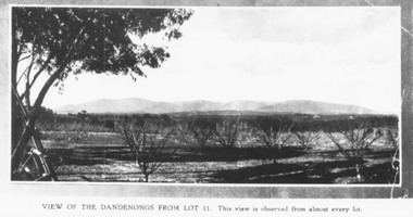 Ringwood and District Historical Society
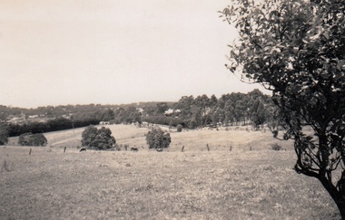
Photograph, Mullers orchard, Heathmont. Looking east from cnr. Canterbury and Dickasons Rds. "Charm View Estate" - 1926
Printed below photograph, "View of the Dandenongs from Lot 11. This view is observed from almost every lot". Written on back of a photograph, "Photo taken from sub. div. plan land sales. Charm View Estate, Heathmont, 1926?" Another copy reads, "Mullers orchard, Heathmont. Taken from cnr. Canterbury and Dickasons Rds. Looking east - 1926". -
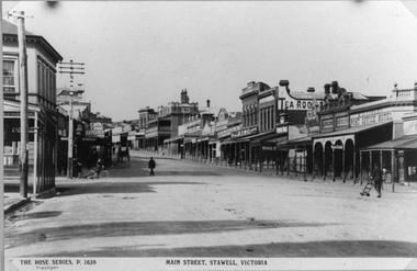 Stawell Historical Society Inc
Photograph, Main Street Stawell looking East towards the Post Office
This photograph is of Main Street Stawell looking East around c 1920's. The photo was taken from just below Main & Wimmera Street corner. On the left side is the two story Post Office building. The photograph shows the telegraph poles in the street. Also Copley Post Office Hotel 1912- 22 and other business. On the road are a few people one pushing a trolly, one on a bike and two people in a horse drawn cart. Gustav Mahnke's Bakery is on right.Two Black & White photographs depicting the main street in Stawell's commercial business area in c 1920's. The view shows some two story buildings, shops with verandah's. One horse drawn vehicle, a person on a bike and a few people in the street. There is also a paper print of the photograph donated by Robyn Mackenzie Bacchus Marsh in 2009 The Rose series, P 1639 Main Street, Stawell, Victoriastawell business shops streetscape -
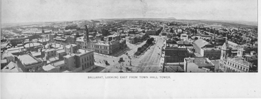 Ballarat Tramway Museum
Photograph - Illustration, "Ballarat Looking East from Town Hall Tower", c1900
Set of two wide-angle views - both with the initials HJS and PS&Co in the bottom corners. 1 - Illustration titled - "Ballarat Looking East from Town Hall Tower" - with a horse tram turning from Sturt St into Lydiard St North and another running westbound on the north side of Sturt St. 2 - "Town Hall to Bridge St from GPO Tower" - There are no horse trams in the view. The National Mutual building is yet to be built - see reference.Yields information about Sturt St from Bridge St to Armstrong St.Illustration cut from a magazine or publicationballarat, illustrations, sturt st, lydiard st, town hall, national mutual, craigs hotel, horse trams