Showing 2015 items matching "the met"
-
 Melbourne Legacy
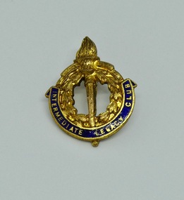
Badge, Intermediate Legacy Club Badge
An example of a Melbourne Intermediate Legacy Club Badge. The pin has a cover that screws onto the shaft of the pin to keep it in place. ILC was formed from junior legatees who had become too old for the usual junior legatee activities. It was most active from the 1930s to 1950s. The badge of Legacy is the Torch and Wreath of Laurel. The Torch signifies the undying flame of service and sacrifice of those who gave their lives for their country. The Wreath of Laurel is the symbol of our remembrance of them. Background: The ILC was formed in 1929. The idea of the club sprang from those boys who had outgrown the Junior Legacy Club. In the early days it fielded a lacrosse team and it was this that mainly held the members together. Enthusiasm wained after a few years as it lacked a solid objective. The answer came from one of its members and in 1938 they founded the Don Esses Club. This was a club for the children of incapacitated ex-servicemen which met every Thursday night at 7.30 run by the ILC members. The name came from the signallers' code Disabled Servicemen's Sons. During the second world war 80% of the members of the ILC enlisted in the services. Leaving only 8 members that could not join due to ill health or reserved occupations. They continued the Don Esses and whatever aid they could to Legacy. ILC members had always helped Legacy where possible including being camp leaders or camp staff, with the annual demonstrations, and coffee stalls at the ANZAC dawn service. Post second world war some ILC members were nominated into Legacy, others drifted away in civil occupations. It was found difficult to recruit new blood into the ILC and eventually membership waned when the boys from the Don Esses clubs found other youth activities to join. The ILC ceased to meet regularly in the mid fifties. However a strong comradeship still existed between members and they would meet in one anothers homes. Members were always ready to help the senior Legacy Club in any way in their power and still helped at Christmas parties and summer camps. ILC was a service rendering organisation and was self governing. Non-sectarian and non-political, the members were ex-junior legatees over 18 years of age. After serving in World War 2 members were eligible to become members of Legacy. Was in a folder of material collated about the ILC by an early archive committee.A record of the badge worn by Intermediate Legacy Club members.Gold lapel pin of the Legacy torch with blue enamel containing the words Intermediate Legacy Club.Imprinted 'Stokes' on reverse.ilc, membership -
 Melbourne Legacy
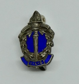
Badge, Intermediate Legacy Club Badge
An example of a Melbourne Intermediate Legacy Club Badge. ILC was formed from junior legatees who had become too old for the usual junior legatee activities. It was most active from the 1930s to 1950s. This badge came from a donation of material from a former Junior Legatee, Valma Hutchinson (nee Wigg). She was involved with the Ladies ILC. The badge of Legacy is the Torch and Wreath of Laurel. The Torch signifies the undying flame of service and sacrifice of those who gave their lives for their country. The Wreath of Laurel is the symbol of our remembrance of them. Background: The ILC was formed in 1929. The idea of the club sprang from those boys who had outgrown the Junior Legacy Club. In the early days it fielded a lacrosse team and it was this that mainly held the members together. Enthusiasm wained after a few years as it lacked a solid objective. The answer came from one of its members and in 1938 they founded the Don Esses Club. This was a club for the children of incapacitated ex-servicemen which met every Thursday night at 7.30 run by the ILC members. The name came from the signallers' code Disabled Servicemen's Sons. During the second world war 80% of the members of the ILC enlisted in the services. Leaving only 8 members that could not join due to ill health or reserved occupations. They continued the Don Esses and whatever aid they could to Legacy. ILC members had always helped Legacy where possible including being camp leaders or camp staff, with the annual demonstrations, and coffee stalls at the ANZAC dawn service. Post second world war some ILC members were nominated into Legacy, others drifted away in civil occupations. It was found difficult to recruit new blood into the ILC and eventually membership waned when the boys from the Don Esses clubs found other youth activities to join. The ILC ceased to meet regularly in the mid fifties. However a strong comradeship still existed between members and they would meet in one anothers homes. Members were always ready to help the senior Legacy Club in any way in their power and still helped at Christmas parties and summer camps. ILC was a service rendering organisation and was self governing. Non-sectarian and non-political, the members were ex-junior legatees over 18 years of age. After serving in World War 2 members were eligible to become members of Legacy.A record of the badge worn by Intermediate Legacy Club members.Lapel pin of the Legacy torch with blue enamel containing the letters I.L.C.Imprinted 'Stokes' on reverse.ilc, membership -
 Melbourne Legacy
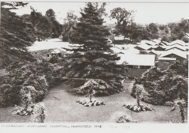
Photograph, Harefield UK, 1919
Copies of photos of the No 1 Australian Auxiliary Hospital set up in the ground of Harefield Park during the first World War. They were wooden huts. Also the graves of the deceased soldiers in the Australian Military Cemetery in 1919 in Harefield's St Mary's churchyard. Plus two photos of the Mansion at Harefield one in 1917 and one from 1927. Harefield Park was owned by Australian couple, Letitia Billyard-Leake (born Letitia Leake) and her husband Charles Billyard and their 4 children. The family donated their property, Harefield Park, to the Australian Government for use as an Australian-run hospital. The family moved off the property and lived nearby to help run the hospital. Letitia and her daughter, also named Letitia, ran the canteen while Charles Billyard organised activities and was a hospital board member. (from research from Carol Grbich and John Berger). During World War 1 the Australian Auxiliary Hospital No.1 was stationed at Harefield Park in Harefield, UxBridge, Middlesex UK. 111 Australian soldiers and one nurse from the hospital are buried at St Mary's Church, Harefield. This became an Australian Military Cemetery with individual headstones and an obelisk and arch. The headstones which are of a scroll design unique amongst Commonwealth War Graves Commission cemeteries were chosen by the staff and patients at the hospital. The arch was erected by the CWGC. Anzac Day services are held there and the local school became involved with the headmaster, Mr Jefferies, bringing the school children to lay flowers on every grave and attend the service on Anzac Day. This started in 1921 and has continued until at least 2021. One school child who attended was Mr Alf Young, he made contact with Legacy in the 1990s and sent photos of the Anzac Day Services and the cemetery. Legacy responded by sending Australian flags for the school children and also Legatee John Cohen met with Mr Young when in London. Melbourne Legacy staff member Susie Howard also visited Mr Young and the cemetery in 1995. Mr Young provided historical photos and information of the area to Legacy. He was featured in the widows' newsletter The Answer many times and his death was announced in The Answer in April 1997, he was 85. Many of the photos he provided were labelled as coming from Mr R G Neil, Photographic historian from Harefield. He holds copyright over those photos.A record that Legacy helped support remembrance of Anzac Day and World War 1 soldiers buried in the UK.Black and white photos x 4 of the Harefield Hospital and area from 1917 to 1927.02067.1 Printed on front 'Australian Auxiliary Hospital, Harefield No 1. 1914-1918'. Handwritten on reverse 'Harefield Park 1917'. Handwritten label 'Hospital as it was 1916-1918'. 02067.2 Handwritten on the reverse 'Part of the old Australian cemetery 1919'. Handwritten label 'The grave on the left "Private Wake" was the first grave in the cemetery'. 02067.3 Printed on the front 'The Lake, Australian Hospital Harefield Park, Mdx.' Handwritten on reverse 'Harefield Park 1917'. Handwritten label 'The lake in front of the mansion 1917'. 02067.4 Printed on the front 'Harefield Park' and 'Coles Watford'. Handwritten on reverse 'The Mansion, 1927 Harefield Park'. All four have a sticker of Mr RG Neil, the photograph historian that provided the reprint.cemetery, harefield, alf young, memorial, wreath laying ceremony, hospitals -
 Flagstaff Hill Maritime Museum and Village
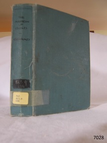
Book - Maritime Novel, Joseph Conway, The Arrow Of Gold, 1919
This book was written by the renowned maritime author Joseph Conrad. Joseph Conrad, author, (1857-1927): - Joseph Conrad was Polish-born and became a British subject in 1886. He was a renowned marine fiction writer and also, for a short time, a mariner and Captain. As a boy of 13 years old, Joseph Conrad’s desire was to be a sailor. At 19, he joined the British merchant marine, working in several roles. He eventually qualified as a captain but only served in this role once, from 1888-89, when he commanded the barque Otago sailing from Sydney to Mauritius. In 1889 he also began writing his first novel, Almayer’s Folly. He retired from life as a mariner in 1894, aged 36. Conrad’s visits to Australia from 1878 to 1982, and his affection for Australia, were later commemorated by a plaque in Circular Quay, Sydney. Conrad continued as an author. It is said that many of the characters in his books were inspired by his maritime experiences and the people he had met. By the end of his life, he had completed many stories and essays, and 19 novels, plus one incomplete novel titled ‘Suspense’ that was finished and published posthumously. Shortly before he passed away, in 1924, Conrad was offered a Knighthood by Prime Minister Ramsay MacDonald for his work but declined. About the Pattison Collection: - The Pattison Collection is a group of books and records that was originally owned by the Warrnambool Mechanics’ Institute, (WMI) which was founded in Warrnambool in 1853. In 1935 Ralph Pattison was appointed as City Librarian to establish and organise the Warrnambool Library as it was then called. When the WMI building was pulled down in 1963 a new civic building was erected on the site and the new Warrnambool Library, on behalf of the City Council, took over all the holdings of the WMI. At this time some of the items were separated and identified as the ‘Pattison Collection’, named after Ralph Pattison. Eventually, the components of the WMI were distributed from the Warrnambool Library to various places, including the Art Gallery, Historical Society and Flagstaff Hill. Later some were even distributed to other regional branches of Corangamite Regional Library and passed to and fro. It is difficult now to trace just where all of the items have ended up. The books at Flagstaff Hill Maritime Village generally display stamps and markings from Pattison as well as a variety of other institutions including the Mechanics’ Institute itself. The book is significant for its connection with the renowned maritime author Joseph Conrad. It is also important for being part of the historic group of books called the Pattison Collection, along with other items at Flagstaff Hill Maritime Village, which was originally part of the Warrnambool Mechanics' Institute’s collection. The Warrnambool Mechanics’ Institute Collection is primarily significant in its totality, rather than for the individual objects it contains. Its contents are highly representative of the development of Mechanics' Institute libraries across Australia, particularly in Victoria. A diversity of publications and themes has been amassed, and these provide clues to our understanding of the nature of and changes in the reading habits of Victorians from the 1850s to the middle of the 20th century. The collection also highlights the Warrnambool community’s commitment to the Mechanics’ Institute, reading, literacy and learning in the regions, and proves that access to knowledge was not impeded by distance. These items help to provide a more complete picture of our community’s ideals and aspirations. The Warrnambool Mechanics Institute book collection has historical and social significance for its strong association with the Mechanics Institute movement and the important role it played in the intellectual, cultural and social development of people throughout the latter part of the nineteenth century and the early twentieth century. The collection of books is a rare example of an early lending library and its significance is enhanced by the survival of an original collection of many volumes. The Warrnambool Mechanics' Institute’s publication collection is of both local and state significance.The Arrow Of Gold: A Story Between Two Notes Author: Joseph Conrad Publisher: T Fisher Unwin Date: 1919 Blue hardcover book with title and call numbers on spine, and handwritten pencil inscription on ply page. Also stockers on the front endpaper have inscriptions and a stamp. The book is part of the Pattison Collection. Spine label, typed text: "PAT 823.9 CON" Sticker on Pastedown front endpaper; "Warrnambool Public Library" covered by a sticker; "Corangamite Regional Library Service" Front loose endpaper is stamped; "Corangamite Regional Library Service"flagstaff hill, flagstaff hill maritime museum and village, warrnambool, maritime museum, maritime village, great ocean road, shipwreck coast, joseph conrad, captain joseph conrad, maritime author, marine author, nautical author, sailor, seafarer, georg stage, 1882 ship, danish ship, training ship, boys killed, alan villiers, ship joseph conrad, mystic seaport, museum ship, warrnambool mechanics institute, pattison collection, warrnambool library, ralph eric pattison, corangamite regional library service, the arrow of gold -
 Mission to Seafarers Victoria
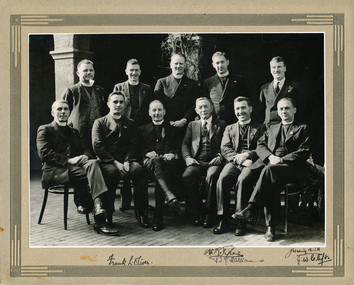
Photograph - Photograph, Black and white, Conference of Australasian Chaplains, Melbourne, 1936, 1936
The photograph is a record of a historic conference of MTS representatives from Australia and New Zealand. , September 1-3 , 1936: Revd Wm Hoog (Brisbane) Revd W.H. Terry (Port Pirie) Revd H.C Cuthbertson (Adelaide) Revd W.R. Tyler (Melbourne) Mr J.W. Neill (Melbourne) Revd. F. J. Evans (Sydney) Revd Frank L. Oliver ( Melbourne MTS) F W Melbourne (Archbishop F W Head 1929- 1942) Mr J.C. Grahame (Hobart) Rev B.J. Williams ((Wellington NZ) Rev J.C. Clift (Fremantle) From the Argus (Melbourne, Vic. : 1848 - 1957), Saturday 5 September 1936, page 34: "For three days this week chaplains of missions to seamen in different ports of Australia and New Zealand met in conference in Melbourne. Bishop Stephen, chairman of the executive committee of the mission in Melbourne, presided over the conference, which was opened by Archbishop Head celebrating Holy Communion in the Chapel of St. Peter at the mission. Among the questions considered was the problem of foreign vessels, from which nothing is contributed toward the support of the missions. It was felt that there was great scope for work of an international character, and that every effort should be made by the chaplains to bring men from the ships of different countries together. The chaplains said that many thousands of men from foreign ships attended the mission institutes. Efforts will be made for more contact to be made with men on coastal ships, and commendation of men from one port to the next will ensure that the needs of men are cared for as well as possible. An ordained chaplain will be sent from London for a new mission at Geraldton (WA), and a new mission will also be opened at Port Kembla (N.SW.). The chaplains will endeavour to obtain police cooperation in keeping docks and wharves free from undesirable persons. It is hoped that an effort will be made to seek the co-operation of the port authorities in order to ensure the pos-sibility of ships being allowed to be alongside during week-ends and public holidays without having to face the full port charges. To avoid the heavy charges the ships now anchor in the bay during week-ends and public holidays. Melbourne was chosen as the central port for Australia for supplies for mis-sions to seamen, and it was decided that the conference should be held every three years, in Melbourne. The last was held 11 years ago." The photograph was published in the 1936 Annual ReportThis photograph is representative of the relationship between the Mission to Seafarers Victoria and the Anglican Church. Reverend Frank Oliver served as Chaplain at the Mission to Seafarers Victoria from 1930 - 1960. A gift of £20,000 for the rebuilding of the Port Melbourne institute, which was old and dilapidated, was announced at the conference. Black and white photograph mounted on cardboard with border detail on the front. The photograph is of eleven men, five standing behind six seated. Nine of the men are wearing clerical collars and two are in suit and ties. The photograph appears to have been taken in the courtyard of the Mission to Seafarers Victoria, at 717 Flinders St. Each of the people in the photograph appears to have hand inscribed their names/ signatures on the lower edge of the mountboard.Top edge of mountboard title of occasion and photo in Black ink all upper case: (see title details this record); Lwr edge first line corresponding to back row of group: 'REv Wm Hoog (Brisbane); Revd W.H. Terry (Port Pirie); Rev H.C Cuthbertson (Adelaide) ; Rev W.R. Tyler (Melbourne) ; Mr J.W. Neill (Melbourne) : / Lwr edge second line corresponding to front row seated: "Revd. F. J. Evans (Sydney) ; Revd Frank L. Oliver ( Melbourne MTS); F W Melbourne (Archbishop F W Head 1929- 1942); Mr J.C. Grahame (Hobart); Rev B.J. Williams ((wellington NZ).; Rev J.C. Clift (Fremantle); courtyard, chaplains, archbishop melbourne, mission to seafarers, flinders street, frank leslie oliver, conference, australasian chaplains, anglican church, reverends, australia, new zealand, 1936, seamen's mission, chaplains group, chaplain conferences -
 Bendigo Historical Society Inc.
Photograph - 1853 Bendigo Goldfields Petition, abt 1990-2019
The Red Ribbon Movement of 1853 represented a significant series of events in the history of Bendigo. During that year there was much agitation on the Bendigo gold fields, particularly during July and August of 1853, directed against the payment of what the miners called a tax - a licence fee of thirty shillings ($3) a month for the right to search for gold on what was declared Crown land. They had to pay the licence whether they found gold or not. The miners, or diggers as they were called, also resented the means used by the authorities at the time to collect the gold licence - through so-called 'digger hunts'. The miners were expected to carry their licences with them, and the police, who were often untrained, used harsh methods to check these licences. In Bendigo, the miners took to wearing a red ribbon ‘as a symbol of their protest against the licence. Red was a very common colour in items such as shirts, so was readily available. Shopkeepers too tied red ribbons to their premises as a sign of support for the miners. It should be remembered at that time virtually everyone was a miner. The diggers also had their own banner, designed by William Dexter, a china painter from Devon. This flag showed the pick, shovel and cradle representing labour, the scales representing justice, the Roman bundle of sticks meaning unity and the kangaroo and emu of Australia Many thousands of Bendigo miners signed a petition to La Trobe, the Governor of Victoria, protesting against the licence fee. When the Governor rejected the petition, thousands of diggers marched in peaceful protest. Miners from White Hills, Eaglehawk, Golden Square, Kangaroo Flat as well as from Bendigo Flat, converged on what is now Pall Mall and View Point, surrounding the ~government camp on Camp Hill. The camp had been reinforced with soldiers of the 40 Regiment, as the Government feared bloodshed. The miners then gathered on the hill behind View Point to hear from their leaders - among them George Thomson, Captain Harrison, Captain Brown and W.D.C. Denovan. They resolved to pay a token fee often shillings ($1) for the September licence, whenthey met with Commissioners Panton and Wright on Camp Hill. Although Wright and Panton were sympathetic to the miners, the offer was rejected, but no licence fees were collected for September. Thus a possible bloody conflict was averted by the common sense shown by the miners' leaders and the commissioners. It was a truly democratic protest against arbitrary government and preceded the Eureka Stockade Incident by over a year. Bendigo Historical Society Committee on a Tram, two photos, one of five people standing behind a display cabinet, and the second one a Banner stretched across the tram. On the rear of the photo is "L-R Jim Evans, Terry Davidson, Ron Monro." Second from left is Jim Evans (President) and fourth from the left is Terry Davidson, with extreme right, Ron Munro (Vice President). In the cabinet is the 1853 Bendigo Goldfields Petition (Red Ribbon Rebellion) The society holds the petition in digital form. The diggers had their own banner, designed by William Dexter, a china painter from Devon. This flag showed the pick, shovel and cradle representing labour, the scales representing justice, the Roman bundle of sticks meaning unity and the kangaroo and emu of Australia history, bendigo, tram, 1853 bendigo goldfields petition, red ribbon rebellions -
 National Wool Museum
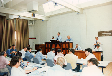
Photograph - Sale Room, National Wool Centre, Geelong, 11 January 1995
This photograph shows bidding underway for the million dollar bale in the Sale Room on the 11th January, 1995 at the National Wool Centre, Geelong. People depicted include Sale Team Baxter Murray, Auctioneer Michael Crooks and Wool Manager Keith Jackson. The wool was shorn from sheep of the Wyndarra and Rockbank bloodlines. A flock of 290 sheep were kept undercover at Kadinia, the property of the Appledore family from Brim in the Wimmera district of Victoria. Their record-breaking wool was produced by giving the sheep a special diet and providing each one with a UV-protective coat. Around 180 fleeces were selected for the million dollar bale. The sale of the first bale of wool measuring below 14 microns was held in the Auction Room here at the National Wool Museum. Bidding began at 40,000 (cents a kilogram) and steadily increased until there were only two bidders left. The bidders represented the Japanese firm Aoki International and Loro Piana of Italy. The hammer fell at 1,030,000 cents per kilogram, with Aoki International paying $1,194,800 for the 116kg bale. The fleece was scoured (cleaned) at the Goulburn Wool Scour, New South Wales. The degree of preparation and care taken with the task was extreme. The Scour closed production three days before and was extensively cleaned. On the day of scouring 12 tonnes of 17 micron wool was washed to condition the water, then nine bales of extra super fine wool, worth over $300,000 was washed as a trial run. Toabo Agaki Japan was employed to process the scoured wool into suit cloth. Taobo required the scoured wool to contain 0.5% residual grease, 12% moisture and a yield of 83kg. These requirements were met. The entire staff of the Scour wanted to be part of washing the best wool in the world. Without asking for payment both the night shift and afternoon shift crews assisted the day shift in the task. The bale was fed into the scour in seven minutes and fitted into three bowls, half the scour. It completely disappeared into the dryer and the last wool was fed before the first wool was out. The clean wool was hand-packed into cardboard cartons and freighted to Japan. Aoki International, based in Yokohama Japan, cut three suit lengths from the cloth, then blended the remaining wool into an exclusive line of commercially-available suits. These suits are labelled Kadinia.Colour photograph showing an interior view of people seated at rows of tables with an auctioneers stand at front of the room.michael crooks, auctioneer, wool industry, million dollar bale, geelong, auction, kadinia, appledore, keith jackson, sale room -
 National Wool Museum
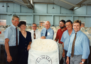
Photograph - Million Dollar Bale, National Wool Centre, Geelong, Gordon Robertson, 11 January 1995
This photograph shows Growers Ian Appledore, Kaye Appledore and Murray Appledore, Wool Manager Keith Jackson, Wool Classer Phillip Gibson, Geoff Allibon and Brendan Dart posing with the million dollar bale after it was sold on 11th January 1995 in Geelong. The wool was shorn from sheep of the Wyndarra and Rockbank bloodlines. A flock of 290 sheep were kept undercover at Kadinia, the property of the Appledore family from Brim in the Wimmera district of Victoria. Their record-breaking wool was produced by giving the sheep a special diet and providing each one with a UV-protective coat. Around 180 fleeces were selected for the million dollar bale. The sale of the first bale of wool measuring below 14 microns was held in the Auction Room here at the National Wool Museum. Bidding began at 40,000 (cents a kilogram) and steadily increased until there were only two bidders left. The bidders represented the Japanese firm Aoki International and Loro Piana of Italy. The hammer fell at 1,030,000 cents per kilogram, with Aoki International paying $1,194,800 for the 116kg bale. The fleece was scoured (cleaned) at the Goulburn Wool Scour, New South Wales. The degree of preparation and care taken with the task was extreme. The Scour closed production three days before and was extensively cleaned. On the day of scouring 12 tonnes of 17 micron wool was washed to condition the water, then nine bales of extra super fine wool, worth over $300,000 was washed as a trial run. Toabo Agaki Japan was employed to process the scoured wool into suit cloth. Taobo required the scoured wool to contain 0.5% residual grease, 12% moisture and a yield of 83kg. These requirements were met. The entire staff of the Scour wanted to be part of washing the best wool in the world. Without asking for payment both the night shift and afternoon shift crews assisted the day shift in the task. The bale was fed into the scour in seven minutes and fitted into three bowls, half the scour. It completely disappeared into the dryer and the last wool was fed before the first wool was out. The clean wool was hand-packed into cardboard cartons and freighted to Japan. Aoki International, based in Yokohama Japan, cut three suit lengths from the cloth, then blended the remaining wool into an exclusive line of commercially-available suits. These suits are labelled Kadinia.Colour photograph showing three six men and one woman standing around a bale of wool.michael crooks, auctioneer, wool industry, million dollar bale, geelong, auction, kadinia, appledore, keith jackson, sale room, geelong wool centre -
 Eltham District Historical Society Inc
Document - Folder, Mann, John and Violet and family
John Mann arrived from Forfar, Scotland, on the clipper packet "Ellen Stuart" in 1857 and rented a farm "Overton" at Janefield. Soon after he met Melbourne-born Violet McKimmie, whose parents had a property near Darebin Creek. They married on 25 September 1862, John 26 and Violet 19. In 1874 John selected a block on Arthurs Creek and built a slab and bark hut (still standing in 1984) and called their farm "Carseburn" after John's parish in Scotland. They had seven children: John, Jane, Christine, David, Walter, James and Violet. John was drowned in the Yarra in May 1875 and Violet struggled to meet the lease commitment. She wrote to her brother-in-law David Mann in New Zealand who came to her aid, and on 10 September 1876, they married at the Victorian Free church, Smith Street, Collingwood. They improved the farm and built a three-room house. in July 1883 they bought neighbouring land from Ann Welsh. With David, Violet had four more children: Robert, William and twins Thomas and Henry. In 1883, David died and was buried in the same grave as his brother in Preston Cemetery. The twins also died, Thomas just before and Henry just after their father. the children assisted with the farm and orchard, the business including crops, a dairy herd, Carseburne sheep, and breeding horses. Violet died at Yan Yean in 1925, aged 83. A grandson of John Mann, James Mann, lived in Henry Street, Greensborough and had given a talk at the Whittlesea Historical Society in 1983 on his family. Descendant Lindsay Mann was part of a creative writing group that published a book including a short story "The Mountain Tramway" is loosely based on his childhood and stories he was told then but was planning to write his family story. Contents Newspaper article: "Tragedy couldn't stop this pioneer", Diamond Valley News, 31 January 1984, story of Mann family. Newspaper article: "Tracing the history of ordinary. people," Diamond Valley News, 29 July 1986, story of Mann family, researched by descendant Lindsay Mann who grew up at the Mann property She-Oak at Yan Yean and has numerous family records. Newspaper article: "A realist who captures light," Diamond Valley News, 29 July 1986, David Moore, a realist painter had been working from a studio at Montsalvat and his exhibition of work from that period was to open 1 August 1986 at the Victorian Artists Society Galleries.Newspaper clippings, A4 photocopies, etcjohn manan, violet mann nee mckimmie, clipper packet "ellen stuart", forfar scotland, darebin creek victoria, arthurs creek victoria, "overton" at janefield, "carseburn" at arthurs creek, jane mann, christine mann, david mann, walter mann, james mann, violet mann, victorian free church smith street collingwood, ann welsh, robert mann, william mann, thomas mann, henry mann, preston cemetery, carseburne sheep, yan yean cemetery, lindsay mann, david moore, montsalvat -
 Flagstaff Hill Maritime Museum and Village
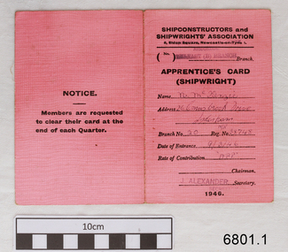
Financial record - Membership Card, Shipconstructors’ and Shipwrights’ Association, Shipconstructors' and Shipwrights' Association, 1946
Several items once belonging to shipwright Norman McKenzie were donated to Flagstaff Hill Maritime Museum and Village. They relate to Norman’s apprenticeship and certification as a Shipwright in Belfast, his Union membership and his employment as a shipwright in Melbourne. One of the items, a union Rules Book inscribed with the name H.B. Thomas and dated 1902, had within its pages Norman’s Indenture of Apprenticeship, dated 1941, Norman Desmond McKenzie was born in Belfast in 1925 and lived at 10 Pansy Street Belfast, Northern Ireland. At the age of 16 years, he began a 5-year Shipwright’s apprenticeship with Harland & Wolff Limited, Shipbuilding & Engineering Works, Belfast. He was a member of the Ship Constructors’ and Shipwrights’ Association, Belfast (B) Branch 20. His Registration Number was 38748. He completed his apprenticeship on December 16th, 1946, aged 21 years, his address was 26 Connsbrook Drive, Sydenham, N. Belfast. In October 1949 Norman received Clearance from his Union as a financial member to move to another branch. He had completed his Apprenticeship on December 16th 1946. Two months later he migrated to Australia, arrived in Victoria and became a Financial Member of the Victorian branch of the Federated Shipwrights, Ship Constructors, Naval Architects, Ships’ Draughtsmen and Boat Builders’ Association of Australia, Victoria branch. One of Norman’s donated books is the Rules of the Shipwrights' Provident Union of the Port of London. It is inscribed on several pages with the name H.B. Thomas and includes the year 1902 and the address of 29 Brickwood Street, Gardenvale. This is a location in Victoria, Australia. The Victoria Government Gazette, February 1959, in the section “Removal from Registration on The Architects Registration Board of Victoria, during the year ended 31st December 1956” lists “Deceased – Thomas, H.B., 29 Brickwood Street, Gardenvale”. The Architects Union includes Naval Architects and Shipwrights and other trades that came under the same union. It seems likely that when he was in Melbourne, Norman worked as a Shipwright for H.B. Thomas and was given the Rules book by Thomas, perhaps as a reference book or maybe as a gift. Around that same time, December 1949, Norman met his wife-to-be, Daphne, in Melbourne. Daphne had migrated from London with her family and her father found work with the Melbourne Harbour Trust. They married in Melbourne in 1953 and their family grew to include five children. In 2003 Norman and Daphne moved to Warrnambool and then years later they celebrated their 60th wedding anniversary. Norman passed away on July 28th 2015 at Warrnambool’s South West Healthcare hospital.Norman McKenzie's Rules Book, Union Cards, Indenture of Apprenticeship, and other documents tell the story of a young Irish lad's work and qualifications to become a shipwright and his migration to Australia. The young man found a job and a wife who had also migrated, and they raised a family in Melbourne. He and his wife then retired to Warrnambool to enjoy their later years. The collection of documents relating to Norman McKenzie is significant for its connection with the shipping industry of the early 1900s, the migration of qualified tradesmen to Victoria, and their contribution to the development of Victoria. The collection also shows the role of the Union in the shipping industry. The documents link shipwright Norman McKenzie to the Shipwright's Union in London and in Australia, and to shipbuilder H B Thomas in Melbourne, most likely his employer.- Apprentice's Membership Card, Shipconstructors' and Shipwrights' Association; pink fabric covered card covers with white paper pages that record the member's contributions. for the year 1946 - enclosed within the Card is a printed and signed white paper Certificate of Shipwrights' Clearance Line, Shipconstructors' and Shipwrights' Association, Branch Transfer papers for N.McKenzie, 1st October 1949. ON THE CARD: Stamped "BELFAST (B) branch" "J ALEXANDER" Handwritten "N. McKenzie, 26 Connsbrook Drive, Sydenham," NIR", (Branch Nu.) "20", (Reg No.) "38748" "9/3/46", (Rate) "APP" ON CERTIFICATE: "(99) BELFAST B" "N McKenzie" "NIR" "38748" (Member No.) "221" "24" (years of age) (CLASS OF MEMBER" "Full Benefit" "!st October 1949" (Signature Of) "John Alexander"union card, apprentice shipwright, branch transfer papers, union membership, m mckenzie, 1946, flagstaff hill, warrnambool, maritime village, maritime museum, shipwreck coast, great ocean road, norman mckenzie, norman desmond mckenzie, belfast shipwright, shipwright's apprenticeship, harland & wolff limited, shipbuilding & engineering works, the ship constructors’ and shipwrights’ association, registered shipwright, victorian branch of the federated shipwrights, ship constructors, naval architects, ships’ draughtsmen and boat builders’ association of australia, victoria branch, shipwrights' provident union, h.b. thomas, architects registration board of victoria, naval architect, daphne, norman and daphne mckenzie, indenture of apprenticeship, 1941, 1949 -
 Flagstaff Hill Maritime Museum and Village
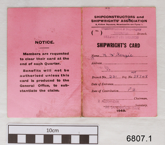
Financial record - Union Membership, Shipconstructiors’ and Shipwrights’ Association et al, From 1941 to 1950
A number of items once belonging to shipwright Norman Desmond McKenzie were donated to Flagstaff Hill Maritime Museum and Village. They are related to Norman’s apprenticeship and certification as a Shipwright in Belfast, his Union membership and his employment as a shipwright in Melbourne. One of the items, a union Rules Book inscribed with the name H.B. Thomas and dated 1902, had within its pages Norman’s Indenture of Apprenticeship, dated 1941, Norman Desmond McKenzie was born in Belfast in 1925 and lived at 10 Pansy Street Belfast, Northern Ireland. At the age of 16 years, he began a 5-year Shipwright’s apprenticeship with Harland & Wolff Limited, Shipbuilding & Engineering Works, Belfast. He became a member of the Ship Constructors’ and Shipwrights’ Association, Belfast (B) Branch 20. His Registration Number was 38748. He completed his apprenticeship on December 16th, 1946, aged 21 years, his address was 26 Connsbrook Drive, Sydenham, N. Belfast. In October 1949 Norman received Clearance from his Union as a financial member to move to another branch. He completed his Apprenticeship on December 16th 1946. Two months later he migrated to Australia, and he arrived in Victoria, and he became a Financial Member of the Victorian branch of the Federated Shipwrights, Ship constructors, Naval Architects, Ships’ Draughtsmen and Boat Builders’ Association of Australia, Victoria branch. One of Norman’s donated books is the Rules of the Shipwrights' Provident Union of the Port of London. It is inscribed on several pages with the name H.B. Thomas and includes the year 1902 and the address of 29 Brickwood Street, Gardenvale. This is a location in Victoria, Australia. The Victoria Government Gazette, February 1959, in the section “Removal from Registration on The Architects Registration Board of Victoria, during the year ended 31st December 1956” lists “Deceased – Thomas, H.B., 29 Brickwood Street, Gardenvale”. The Architects Union includes Naval Architects and Shipwrights and other related trades came under the same union. It seems likely that when he was in Melbourne, Norman worked as a Shipwright for H.B. Thomas and was given the Rules book by Thomas, perhaps as a reference book or maybe as a gift. Around that same time, December 1949, Norman met his wife-to-be, Daphne, in Melbourne. Daphne had migrated from London with her family and her father found work with the Melbourne Harbour Trust. They married in Melbourne in 1953 and went on to have a family of five children. In 2003 Norman and Daphne moved to Warrnambool and then years later they celebrated their 60th wedding anniversary. Norman passed away on July 28th 2015 at Warrnambool’s South West Healthcare hospital.Norman McKenzie's Rules Book, Union Cards, Indenture of Apprenticeship, and other documents tell the story of a young Irish lad's work and qualifications to become a shipwright and his migration to Australia. The young man found a job and a wife who had also migrated, and they raised a family in Melbourne. He and his wife then retired to Warrnambool to enjoy their later years. The collection of documents relating to Norman McKenzie is significant for its connection with the shipping industry of the early 1900s, the migration of qualified tradesmen to Victoria, and their contribution to the development of Victoria. The collection also shows the role of the Union in the shipping industry. The documents link shipwright Norman McKenzie to the Shipwright's Union in London and in Australia, and to shipbuilder H B Thomas in Melbourne, most likely his employer.Documents owned by Norman Desmond McKenzie, Shipwright: (1) Shipwright's card with a pink cover and record of contributions for 1949 (2) Clearance Certificate from Victorian Branch of the Federated Shipwrights' Ship Constructors, Naval Architects, Ships' Draughtsmen and Boat Builders' Association of Australia, 14-12-1949,4-12-1949 (3) Contribution book with blue cover and stapled in pages with payment records for 1947 (4) Apprenticeship and Employment Reference, typed, from Harland & Wolff Ltd. Shipbuilding & Engineering Works, Belfast, dated 9-9-1949SHIPWRIGHT'S CARD - Printed: "SHIPWRIGHT'S CARD" "SHIPCONSTRUCTORS and SHIPWRIGHTS' ASSOCIATION" "8, Eldon Square, Newcastle-on-Tyne 1". "J ALEXANDER, SECRETARY", "38 Sandbrook Park" Stamped "BELFAST (B) BRANCH" . Handwritten "N McKenzie" "221" (Reg.) "38748" "PB" CLEARANCE CERTIFICATE: Printed "Federated Shipwrights', Ship Constructors', Naval Architects', Ships' Draftsmen and Boat Builders' Association of Australia" Handwritten "Dec 14 [19] 49", "Norman D McKenzie" ""Victorian [BranchH]" "'til Feb 1st 1950" CONTRIBUTION BOOK: Printed "BELFAST SHIPWRIGHT'S MUTUAL AID ASSOCIATION" "CONTRIBUTION BOOK" Stamped "Herbert Taylor" Handwritten "N McKenzie" "415" EMPLOYMENT REFERENCE: Printed "HARLAND & WOLFF Limited, Shipbuilding & Engineering Works, Belfast" Typed "9th September 1949" and "This is to certify that Norman D. MaKenzie, 26 Connstrook Drive, Belfast, served a five-year Apprenticeship with us as a Shipwright, completing this on the 16th December 1946. He continued in our employment, and is now leaving of his own accord. We would state that during the time Mr. McKenzie was with us, he was a good workman and steady timekeeper."flagstaff hill, warrnambool, maritime village, maritime museum, shipwreck coast, great ocean road, norman mckenzie, norman desmond mckenzie, belfast shipwright, shipwright's apprenticeship, harland & wolff limited, shipbuilding & engineering works, the ship constructors’ and shipwrights’ association, registered shipwright, victorian branch of the federated shipwrights, ship constructors, naval architects, ships’ draughtsmen and boat builders’ association of australia, victoria branch, shipwrights' provident union, h.b. thomas, architects registration board of victoria, naval architect, daphne, norman and daphne mckenzie, indenture of apprenticeship, 1941, 1946, 1947, 1949, 1953, union card, shipwright’s association card, n mckenzie, certificate of clearance -
 City of Moorabbin Historical Society (Operating the Box Cottage Museum)
Photograph, B/W Laminated of August Rietman Family c 1918, c1918
August Rietmann 1877-1951 and his wife Frieda 1878-1942 leased the Box Cottage in 1917 and raised 2 children Stefanie 1918-2006, and William 1920– 1997. August was a Monumental Mason / Potter / Sculptor and he was employed at Corbens Ltd Clifton Hill, to make the War Memorials for many towns post WW1. August purchased the property 1935,and established a pressed concrete business using the cottage as a workshop and storeroom After August died in 1951, William, his son, continued to work in the business from the site until the land was sold to Lewis Co. Ltd Timber Merchants in 1970. Rietman's Landscaping Ltd , managed by William's family, moved to Bay Road Highett 1953 and later to Carrum. The original small, pioneer cottage was built in the late 1840s to early1850s, by an unknown pioneer. It was located on part of a 30 Acre allotment that was originally part of Dendy’s Special Survey granted in 1841. The doors and window sashes, (made of red deal joinery timber), as well as the brass locks and fittings, are from the original cottage, and were imported from England. The fire-place bricks are from the original cottage, and are sun-dried, (not kiln fired), and are hand-made. Convict marks can be seen on two bricks. There is a small display of external cladding shingles from the original pioneer cottage. These shingles were hand-split, and most likely made from locally collected timber The nails included in this display were used to fasten the shingles on the original cottage, and are also hand-made. The cottage was occupied by William Box and family from 1865 until 1914 when it was sold to August Rietman . The enamel nameplate, “Colonial”, on the wall of the cottage, was the name chosen for the original pioneer cottage by Mr August Rietman, when he purchased the property in around 1915, for 1200 Pounds approximately. In 1974 Mr Lewis, a timber specialist, found the dilapidated building on property he had recently purchased in Jasper Rd and suggested it be reconstructed and relocated. Moorabbin Council agreed and the cottage was rebuilt just about 250 metres from its original site. The cost of the rebuild was met by 'Victoria's 150th Committee, plus a small grant from the City of Moorabbin, and Mr Laurie Lewis donated much of the timber for the reconstruction. The re-constructed cottage plan has followed faithfully the original dimensions, and plan of the original pioneer cottage, and as many original items from that cottage’s long occupation have been incorporated. The photographs in Album 1 record the progress of the reconstruction from February 1984 to the First Public Open Day November 18th 1984After the death of Elisa Box in 1914 the house was leased to August Rietmann, a potter / sculptor who with his wife Fieda raised their family there 1917 - 1951. Stefanie Rennick nee Rietman lived at the house until she left to study teaching 1937. August's son, William Rietman and family managed Rietman's Landscaping Ltd after moving to Bay Road Highett 1953 and later to Carrum. The Lewis Timber Company Ltd purchased the land with The Cottage c1970. i) A laminated, black and white, photograph of August Rietmann and Family c1918 at Box Cottage, Ormond, Molly the house cow is in foreground ii) Colour photograph of Rietman's Landscaping Ltd. Bay Road Highett c 1990brighton, moorabbin, cottages, pioneers, ormond, colonial, mckinnon, dendy henry, box william, box elizabeth, reitman august, convicts lewis timber co. ltd., deam h, museums, box alonzo, smith a, rietmann august, rietman august, rietmann frieda, rietman frieda, stonnington city town hall, war memorials, world war 1 1914-1918, rietman stefanie, rennick stefanie, francis stefanie, rietman william, rietman ray, mountford paul, malvern city town hall, box cottage museum ormond, joyce park ormond, rietman's landscaping pty ltd, bay road highett, macrobertson pty ltd, coleraine soldier memorial 1921, dendy, rietman agust, convicts, macrobertson, war memorial -
 Flagstaff Hill Maritime Museum and Village
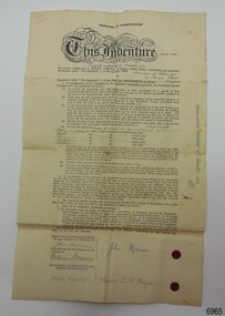
Document - Certificate, Harland & Wolff Limited, Shipbuilding & Engineering Works, Indenture of Apprenticeship, 28th October 1941
A number of items once belonging to shipwright Norman McKenzie were donated to Flagstaff Hill Maritime Museum and Village. They are related to Norman’s apprenticeship and certification as a Shipwright in Belfast, his Union membership and his employment as a shipwright in Melbourne. One of the items, a union Rules Book inscribed with the name H.B. Thomas and dated 1902, had within its pages Norman’s Indenture of Apprenticeship, dated 1941, Norman Desmond McKenzie was born in Belfast in 1925 and lived at 10 Pansy Street Belfast, Northern Ireland. At the age of 16 years, he began a 5-year Shipwright’s apprenticeship with Harland & Wolff Limited, Shipbuilding & Engineering Works, Belfast. He became a member of the Ship Constructors’ and Shipwrights’ Association, Belfast (B) Branch 20. His Registration Number was 38748. He completed his apprenticeship on December 16th, 1946, aged 21 years, his address was 26 Connsbrook Drive, Sydenham, N. Belfast. In October 1949 Norman received Clearance from his Union as a financial member to move to another branch. He completed his Apprenticeship on December 16th 1946. Two months later he migrated to Australia, and he arrived in Victoria, and he became a Financial Member of the Victorian branch of the Federated Shipwrights, Ship constructors, Naval Architects, Ships’ Draughtsmen and Boat Builders’ Association of Australia, Victoria branch. One of Norman’s donated books is the Rules of the Shipwrights' Provident Union of the Port of London. It is inscribed on several pages with the name H.B. Thomas and includes the year 1902 and the address of 29 Brickwood Street, Gardenvale. This is a location in Victoria, Australia. The Victoria Government Gazette, February 1959, in the section “Removal from Registration on The Architects Registration Board of Victoria, during the year ended 31st December 1956” lists “Deceased – Thomas, H.B., 29 Brickwood Street, Gardenvale”. The Architects Union includes Naval Architects and Shipwrights and other related trades came under the same union. It seems likely that when he was in Melbourne, Norman worked as a Shipwright for H.B. Thomas and was given the Rules book by Thomas, perhaps as a reference book or maybe as a gift. Around that same time, December 1949, Norman met his wife-to-be, Daphne, in Melbourne. Daphne had migrated from London with her family and her father found work with the Melbourne Harbour Trust. They married in Melbourne in 1953 and went on to have a family of five children. In 2003 Norman and Daphne moved to Warrnambool and then years later they celebrated their 60th wedding anniversary. Norman passed away on July 28th 2015 at Warrnambool’s South West Healthcare hospital.Norman McKenzie's Rules Book, Union Cards, Indenture of Apprenticeship, and other documents tell the story of a young Irish lad's work and qualifications to become a shipwright and his migration to Australia. The young man found a job and a wife who had also migrated, and they raised a family in Melbourne. He and his wife then retired to Warrnambool to enjoy their later years. The collection of documents relating to Norman McKenzie is significant for its connection with the shipping industry of the early 1900s, the migration of qualified tradesmen to Victoria, and their contribution to the development of Victoria. The collection also shows the role of the Union in the shipping industry. The documents link shipwright Norman McKenzie to the Shipwright's Union in London and in Australia, and to shipbuilder H B Thomas in Melbourne, most likely his employer.Certificate printed on cream paper; Indenture of Apprenticeship, between Norman McKenzie of Belfast, and Harland & Wolff Ltd. of Queen's Island, Belfast on 28th October 1941. The Certificate was donated within the pages of a book, Rules of the Shipwrights' Provident Union of the Port of London published in 1895 and inscribed in 1905 with the name H. B. Thomas. Inscriptions are on the front and reverse of the certificate. There are two red wax seals beside the signatures of John Morrison and Norman D. McKenzie. Handwritten and underlined in red pen, top right of Certificate's front "1499" Printed on the Certificate, employer "HARLAND & WOLFF Limited, of Queen's Island, Belfast, Shipbuilders and Engineers" Handwritten in black pen "Twenty-eighth (day of ) October 1941" "Norman D. McKenzie, 10 Pansy Street, Belfast" "Shipwright Rates of wages as per National agreement" SIGNED: "John Morrison" "William Donald" "Joseph Kenney" "Norman D. McKenzie" Along the right margin "Apprenticeship completed 16th December 1946" In pencil on the reverse "N McKenzie, 26 Connsbrook Drive, Sydenham, N. Belfast" flagstaff hill, warrnambool, maritime village, maritime museum, shipwreck coast, great ocean road, norman mckenzie, norman desmond mckenzie, belfast shipwright, shipwright's apprenticeship, harland & wolff limited, shipbuilding & engineering works, the ship constructors’ and shipwrights’ association, registered shipwright, victorian branch of the federated shipwrights, ship constructors, naval architects, ships’ draughtsmen and boat builders’ association of australia, victoria branch, shipwrights' provident union, h.b. thomas, architects registration board of victoria, naval architect, daphne, norman and daphne mckenzie, indenture of apprenticeship -
 City of Greater Bendigo - Civic Collection
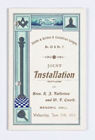
Memorabilia - Invitation and menu card, Joint Installation of Bros. K.J. Fullerton and W. F. Creeth, 1909
Freemasonary or Masonry has its beginnings in local guilds of stonemasons who from the end of 13th century regulated the qualification of stonemasons. Modern Freemasonry uses scriptures which include ritual practices and ethical conduct as part of its foundation and every member must profess a belief in a Supreme Being. Women are not allowed to be admitted and discussion of religion and politics is not to take place within the lodge. Freemasons meet in local Lodges which are supervised at a regional level by a Grand Lodge. The degrees of Freemasonry retain the three grades of medieval craft guilds, those of Entered Apprentice, Journeyman or fellow (now called Fellowcraft), and Master Mason. The candidate of these three degrees is progressively taught the meanings of the symbols of Freemasonry and entrusted with grips, signs, and words to signify to other members that he has been so initiated. The degrees are part allegorical morality play and part lecture. Candidates for Freemasonry will usually have met the most active members of the Lodge they are joining before being elected for initiation. (https://en.wikipedia.org/wiki/Freemasonry) The Golden Lodge of Sandhurst was established as the first Masonic Lodge in Bendigo in 1854. Many prominent men including City Councilors were lodge members at it was a popular way for men to socialise. As the masonic movement expanded further lodges were established in Bendigo and the surrounding Boroughs and Shires. The Golden and Corinthian Lodges purchasing two blocks of land in a prominent position in View Street in 1866 with the intention of erecting a new temple and after amalgamating in 1872 appointed architects Vahland and Getzschmann to design the building. The Bendigo Masonic Hall (now the Capital Theatre) was built in 1873 -74 for both public and private use and contained lodge rooms, a public tavern anda concert hall. The Masonic section occupied the northern side of the building at ground floor level and included a lodge room at the rear, a library and reading room, and other affiliated rooms. Walls of the entry hall and lodge room were decorated with classical columns and panels ornamented with Masonic emblems. The upper level of the building contained a large hall with balcony at the north end and removable stage at the south end. Elaborately decorated with Masonic emblems, this hall was used for Masonic purposes as well as being available to the wider community for social events. The tavern, which became known as the Masonic Hotel, occupied the basement and the ground floor of the southern side of the building and included a sitting room, parlours, billiard room, bedrooms, kitchen, cellars and servants' rooms. It appears that two public entrances were provided for this section, one directly from street level into the basement, the other from the public entry hall. Invitation for the Installation of two Lodge Brothers. Half fold design printed in gold, brown, light blue, dark blue and black ink on white card. Front and back cover decorated with masonic symbols. Menu listed inside. Front cover: Zenith & Golden Corinthian Lodges,/ No. 52 & No. 7./ Joint / Installation / of / Bros. K. J. Fullerton / and W. F Creeth / Masonic Hall / Wednesday, June 30th , 1909 bendigo masonic hall, capital theatre bendigo, milburn catering bendigo, making a nation exhibition, bendigo masonic lodge, city of greater bendigo events, city of greater bendigo community groups -
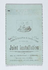 City of Greater Bendigo - Civic Collection
Memorabilia - Invitation and menu card, Joint Installation of Bros. R.T. Trembath and L. A. Sonnenberg, 1910
Freemasonary or Masonry has its beginnings in local guilds of stonemasons who from the end of 13th century regulated the qualification of stonemasons. Modern Freemasonry uses scriptures which include ritual practices and ethical conduct as part of its foundation and every member must profess a belief in a Supreme Being. Women are not allowed to be admitted and discussion of religion and politics is not to take place within the lodge. Freemasons meet in local Lodges which are supervised at a regional level by a Grand Lodge. The degrees of Freemasonry retain the three grades of medieval craft guilds, those of Entered Apprentice, Journeyman or fellow (now called Fellowcraft), and Master Mason. The candidate of these three degrees is progressively taught the meanings of the symbols of Freemasonry and entrusted with grips, signs, and words to signify to other members that he has been so initiated. The degrees are part allegorical morality play and part lecture. Candidates for Freemasonry will usually have met the most active members of the Lodge they are joining before being elected for initiation. (https://en.wikipedia.org/wiki/Freemasonry) The Golden Lodge of Sandhurst was established as the first Masonic Lodge in Bendigo in 1854. Many prominent men including City Councilors were lodge members at it was a popular way for men to socialise. As the masonic movement expanded further lodges were established in Bendigo and the surrounding Boroughs and Shires. The Golden and Corinthian Lodges purchasing two blocks of land in a prominent position in View Street in 1866 with the intention of erecting a new temple and after amalgamating in 1872 appointed architects Vahland and Getzschmann to design the building. The Bendigo Masonic Hall (now the Capital Theatre) was built in 1873 -74 for both public and private use and contained lodge rooms, a public tavern anda concert hall. The Masonic section occupied the northern side of the building at ground floor level and included a lodge room at the rear, a library and reading room, and other affiliated rooms. Walls of the entry hall and lodge room were decorated with classical columns and panels ornamented with Masonic emblems. The upper level of the building contained a large hall with balcony at the north end and removable stage at the south end. Elaborately decorated with Masonic emblems, this hall was used for Masonic purposes as well as being available to the wider community for social events. The tavern, which became known as the Masonic Hotel, occupied the basement and the ground floor of the southern side of the building and included a sitting room, parlours, billiard room, bedrooms, kitchen, cellars and servants' rooms. It appears that two public entrances were provided for this section, one directly from street level into the basement, the other from the public entry hall. Invitation for the Installation of two Lodge Brothers. Horizontal fold printed in black ink on blue card. Embossed cover with scalloped edging. Front and back cover decorated with masonic symbols. Menu listed inside. Front cover: golden & Corinthian & Zenith Lodges / No. 7 and Mo. 52 / joint Installation / of / Bros, R. T. Trembath and L. A. Sonnenber / Masonic Hall, Bendigo / Wednesday, June 29th, 1910. bendigo masonic hall, capital theatre bendigo, milburn catering bendigo, brockley printers bendigo, making a nation exhibition, bendigo masonic lodge, city of greater bendigo community groups, city of greater bendigo events -
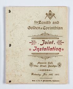 City of Greater Bendigo - Civic Collection
Memorabilia - Invitation and Menu Card, Joint Installation, 1905
Freemasonary or Masonry has its beginning in local guilds of stonemasons which from the end of 13th century regulated the qualification of stonemasons. Modern Freemasonry uses scriptures which include ritual practices and ethical conduct as part of its foundation and every member must profess a belief in a Supreme Being. Women are not allowed to be admitted and discussion of religion and politics is not to take place within the lodge. Freemasons meet in local Lodges which are supervised at a regional level by a Grand Lodge. The degrees of Freemasonry retain the three grades of medieval craft guilds, those of Entered Apprentice, Journeyman or fellow (now called Fellowcraft), and Master Mason. The candidate of these three degrees is progressively taught the meanings of the symbols of Freemasonry and entrusted with grips, signs, and words to signify to other members that he has been so initiated. The degrees are part allegorical morality play and part lecture. Candidates for Freemasonry will usually have met the most active members of the Lodge they are joining before being elected for initiation. (https://en.wikipedia.org/wiki/Freemasonry) The Golden Lodge of Sandhurst was established as the first Masonic Lodge in Bendigo in 1854. Many prominent men including City Councilors were lodge members at it was a popular way for men to socialise. As the masonic movement expanded further lodges were established in Bendigo and the surrounding Boroughs and Shires. The Golden and Corinthian Lodges purchasing two blocks of land in a prominent position in View Street in 1866 with the intention of erecting a new temple and after amalgamating in 1872 appointed architects Vahland and Getzschmann to design the building. The Bendigo Masonic Hall (now the Capital Theatre) was built in 1873 -74 for both public and private use and contained lodge rooms, a public tavern anda concert hall. The Masonic section occupied the northern side of the building at ground floor level and included a lodge room at the rear, a library and reading room, and other affiliated rooms. Walls of the entry hall and lodge room were decorated with classical columns and panels ornamented with Masonic emblems. The upper level of the building contained a large hall with balcony at the north end and removable stage at the south end. Elaborately decorated with Masonic emblems, this hall was used for Masonic purposes as well as being available to the wider community for social events. The tavern, which became known as the Masonic Hotel, occupied the basement and the ground floor of the southern side of the building and included a sitting room, parlours, billiard room, bedrooms, kitchen, cellars and servants' rooms. It appears that two public entrances were provided for this section, one directly from street level into the basement, the other from the public entry hall. Invitation for the Installation of unnamed Brothers. Half fold printed in gold and red ink on cream coloured card. Embossed cover with plain edging. Front and back cover decorated with masonic symbols. Menu listed inside. Front cover: The Zenith and Golden and Corinthian Lodges ? Joint Installation / Masonic Hall, Bendigo / Wednesday, June 28th, 1905 / Bro J.O.R Milburn Caterer bendigo masonic hall, capital theatre bendigo, milburn catering bendigo, making a nation exhibition, james printer eaglehawk, bendigo masonic lodge, city of greater bendigo community groups -
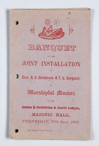 City of Greater Bendigo - Civic Collection
Memorabilia - Invitation, Joint Installation of Bros. R.O. Henderson & T. L. Sargeant, 1906
Freemasonary or Masonry has its beginnings in local guilds of stonemasons who from the end of 13th century regulated the qualification of stonemasons. Modern Freemasonry uses scriptures which include ritual practices and ethical conduct as part of its foundation and every member must profess a belief in a Supreme Being. Women are not allowed to be admitted and discussion of religion and politics is not to take place within the lodge. Freemasons meet in local Lodges which are supervised at a regional level by a Grand Lodge. The degrees of Freemasonry retain the three grades of medieval craft guilds, those of Entered Apprentice, Journeyman or fellow (now called Fellowcraft), and Master Mason. The candidate of these three degrees is progressively taught the meanings of the symbols of Freemasonry and entrusted with grips, signs, and words to signify to other members that he has been so initiated. The degrees are part allegorical morality play and part lecture. Candidates for Freemasonry will usually have met the most active members of the Lodge they are joining before being elected for initiation. (https://en.wikipedia.org/wiki/Freemasonry) The Golden Lodge of Sandhurst was established as the first Masonic Lodge in Bendigo in 1854. Many prominent men including City Councilors were lodge members at it was a popular way for men to socialise. As the masonic movement expanded further lodges were established in Bendigo and the surrounding Boroughs and Shires. The Golden and Corinthian Lodges purchasing two blocks of land in a prominent position in View Street in 1866 with the intention of erecting a new temple and after amalgamating in 1872 appointed architects Vahland and Getzschmann to design the building. The Bendigo Masonic Hall (now the Capital Theatre) was built in 1873 -74 for both public and private use and contained lodge rooms, a public tavern anda concert hall. The Masonic section occupied the northern side of the building at ground floor level and included a lodge room at the rear, a library and reading room, and other affiliated rooms. Walls of the entry hall and lodge room were decorated with classical columns and panels ornamented with Masonic emblems. The upper level of the building contained a large hall with balcony at the north end and removable stage at the south end. Elaborately decorated with Masonic emblems, this hall was used for Masonic purposes as well as being available to the wider community for social events. The tavern, which became known as the Masonic Hotel, occupied the basement and the ground floor of the southern side of the building and included a sitting room, parlours, billiard room, bedrooms, kitchen, cellars and servants' rooms. It appears that two public entrances were provided for this section, one directly from street level into the basement, the other from the public entry hall. Invitation for the Installation of Brothers Henderson and Sargeant. Half fold printed in red ink on grey / mauve coloured card with plain edging. Menu listed inside on left, toasts listed on inside right. Front cover: Banquet / at the / Joint Installation / of / Brox, R. O Henderson & T. L. Sargeant / as / Worshipful Masters / of the / Golden and Corinthian & Zenith Lodges / Masonic Hall / Wednesday, 27th June 1906 bendigo masonic hall, capital theatre bendigo, milburn catering bendigo, making a nation exhibition, brockley printers bendigo, bendigo masonic lodge, city of greater bendigo community groups -
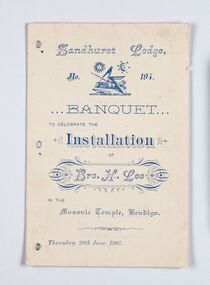 City of Greater Bendigo - Civic Collection
Memorabilia - Invitation, Joint Installation of Bros. H. Lee, 1907
Freemasonary or Masonry has its beginnings in local guilds of stonemasons who from the end of 13th century regulated the qualification of stonemasons. Modern Freemasonry uses scriptures which include ritual practices and ethical conduct as part of its foundation and every member must profess a belief in a Supreme Being. Women are not allowed to be admitted and discussion of religion and politics is not to take place within the lodge. Freemasons meet in local Lodges which are supervised at a regional level by a Grand Lodge. The degrees of Freemasonry retain the three grades of medieval craft guilds, those of Entered Apprentice, Journeyman or fellow (now called Fellowcraft), and Master Mason. The candidate of these three degrees is progressively taught the meanings of the symbols of Freemasonry and entrusted with grips, signs, and words to signify to other members that he has been so initiated. The degrees are part allegorical morality play and part lecture. Candidates for Freemasonry will usually have met the most active members of the Lodge they are joining before being elected for initiation. (https://en.wikipedia.org/wiki/Freemasonry) The Golden Lodge of Sandhurst was established as the first Masonic Lodge in Bendigo in 1854. Many prominent men including City Councilors were lodge members at it was a popular way for men to socialise. As the masonic movement expanded further lodges were established in Bendigo and the surrounding Boroughs and Shires. The Golden and Corinthian Lodges purchasing two blocks of land in a prominent position in View Street in 1866 with the intention of erecting a new temple and after amalgamating in 1872 appointed architects Vahland and Getzschmann to design the building. The Bendigo Masonic Hall (now the Capital Theatre) was built in 1873 -74 for both public and private use and contained lodge rooms, a public tavern anda concert hall. The Masonic section occupied the northern side of the building at ground floor level and included a lodge room at the rear, a library and reading room, and other affiliated rooms. Walls of the entry hall and lodge room were decorated with classical columns and panels ornamented with Masonic emblems. The upper level of the building contained a large hall with balcony at the north end and removable stage at the south end. Elaborately decorated with Masonic emblems, this hall was used for Masonic purposes as well as being available to the wider community for social events. The tavern, which became known as the Masonic Hotel, occupied the basement and the ground floor of the southern side of the building and included a sitting room, parlours, billiard room, bedrooms, kitchen, cellars and servants' rooms. It appears that two public entrances were provided for this section, one directly from street level into the basement, the other from the public entry hall. Invitation for the Installation of Brother Lee. Half fold printed in blue ink on cream coloured card with plain edging. Menu listed inside on left, toasts listed on inside right, officers listed on back cover. Front cover: Sandhurst Lodge / No 194 / Banquet / to celebrate the / Installation / of / Brother H. Lee / in the / Masonic Temple, Bendigo / Thursday, 20th June 1907 bendigo masonic hall, capital theatre bendigo, milburn catering bendigo, making a nation exhibition, bendigo masonic lodge, city of greater bendigo events, city of greater bendigo community groups -
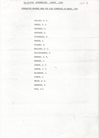 Melbourne Legacy
Document, ILC Foundation Members when the Club Commenced in March 1929. ILC3, 1974
A list of the foundation members of the Intermediate Legacy Club from March 1929. They were: Graham F Billet, Frank C Corrie, Alan Davidson, Roy Davidson, Dan Fitzgerald, Len Frazer, Roy Gilbert, Frank C Holliday, Fred Hollingsworth, EM (Ted) Kennedy, Jack Kennedy, AV Lawson, JV Lawson, Jimmy Macgregor, R Rimmer, Norman A Smith, R Warnecke, Bert S Wood. (Bill Johnston was also mentioned in a letter by Norm Smith as a 'first nighter' see item at 01635). Background: The ILC was formed in 1929 with a total membership of 18 according to this list. The idea of the club sprang from those boys who had outgrown the Junior Legacy Club. In the early days it fielded a lacrosse team and it was this that mainly held the members together. Enthusiasm wained after a few years as it lacked a solid objective. The answer came from one of its members and in 1938 they founded the Don Esses Club. This was a club for the children of incapacitated ex-servicemen which met every Thursday night at 7.30 run by the ILC members. The name came from the signallers' code Disabled Servicemen's Sons. During the second world war 80% of the members of the ILC enlisted in the services. Leaving only 8 members that could not join due to ill health or reserved occupations. They continued the Don Esses and whatever aid they could to Legacy. ILC members had always helped Legacy where possible including being camp leaders or camp staff, with the annual demonstrations, and coffee stalls at the ANZAC dawn service. Post second world war some ILC members were nominated into Legacy, others drifted away in civil occupations. It was found difficult to recruit new blood into the ILC and eventually membership waned when the boys from the Don Esses clubs found other youth activities to join. The ILC ceased to meet regularly in the mid fifties. However a strong comradeship still existed between members and they would meet in one anothers homes. Members were always ready to help the senior Legacy Club in any way in their power and still helped at Christmas parties and summer camps. ILC was a service rendering organisation and was self governing. Non-sectarian and non-political, the members were ex-junior legatees over 18 years of age. After serving in World War 2 members were eligible to become members of Legacy. Was in a folder of material collated about the ILC by an early archive committee. An important list of the initial members of the Intermediate Legacy Club. The ILC was active from 1930 to 1974.White A4 paper with black type of a list of 18 foundation members of the ILC.ilc, membership, junior legatee -
 Melbourne Legacy
Document, Intermediate Legacy Club - Historic Reunion, 1974
A reprint from a Legacy Newsletter on 26/2/1974 about a reunion of Intermediate Legacy Club. It was a mix of Melbourne ILC and Geelong ILC members. Some Legatees attended as well, including Frank Doolan who spoke, plus Kem Kemsley and Jim Gillespie. Intermediate Legatee Jim McGregor was one of Stan Savige's first Junior Legatee Contact, and was very close to L/ Savige. It was one of the last meetings of the ILC as it ceased operations in 1974. The residue of funds held by the club were transferred to the Sir Stanley Savige Memorial Trust No 2. Background: The ILC was formed in 1929. The idea of the club sprang from those boys who had outgrown the Junior Legacy Club. In the early days it fielded a lacrosse team and it was this that mainly held the members together. Enthusiasm wained after a few years as it lacked a solid objective. The answer came from one of its members and in 1938 they founded the Don Esses Club. This was a club for the children of incapacitated ex-servicemen which met every Thursday night at 7.30 run by the ILC members. The name came from the signallers' code Disabled Servicemen's Sons. During the second world war 80% of the members of the ILC enlisted in the services. Leaving only 8 members that could not join due to ill health or reserved occupations. They continued the Don Esses and whatever aid they could to Legacy. ILC members had always helped Legacy where possible including being camp leaders or camp staff, with the annual demonstrations, and coffee stalls at the ANZAC dawn service. Post second world war some ILC members were nominated into Legacy, others drifted away in civil occupations. It was found difficult to recruit new blood into the ILC and eventually membership waned when the boys from the Don Esses clubs found other youth activities to join. The ILC ceased to meet regularly in the mid fifties. However a strong comradeship still existed between members and they would meet in one anothers homes. Members were always ready to help the senior Legacy Club in any way in their power and still helped at Christmas parties and summer camps. ILC was a service rendering organisation and was self governing. Non-sectarian and non-political, the members were ex-junior legatees over 18 years of age. After serving in World War 2 members were eligible to become members of Legacy. Was in a folder of material collated about the ILC by an early archive committee. A record of where the ILC members served in world war two. The ILC was active from 1929 to 1974.White foolscap paper with black type x 2 pages of part of a newsletter in 1974.ilc, reunion -
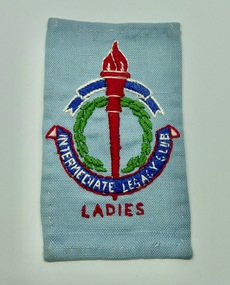 Melbourne Legacy
Badge, Intermediate Legacy Club Ladies Cloth Badge
An example of a Melbourne Ladies Intermediate Legacy Club Badge that was stitched onto clothes. ILC was formed from junior legatees who had become too old for the usual junior legatee activities. It was most active from the 1930s to 1950s. This badge came from a donation of material from a former Junior Legatee, Valma Hutchinson (nee Wigg). She was involved with the Ladies ILC. The badge of Legacy is the Torch and Wreath of Laurel. The Torch signifies the undying flame of service and sacrifice of those who gave their lives for their country. The Wreath of Laurel is the symbol of our remembrance of them. Background: The ILC was formed in 1929. The idea of the club sprang from those boys who had outgrown the Junior Legacy Club. In the early days it fielded a lacrosse team and it was this that mainly held the members together. Enthusiasm wained after a few years as it lacked a solid objective. The answer came from one of its members and in 1938 they founded the Don Esses Club. This was a club for the children of incapacitated ex-servicemen which met every Thursday night at 7.30 run by the ILC members. The name came from the signallers' code Disabled Servicemen's Sons. During the second world war 80% of the members of the ILC enlisted in the services. Leaving only 8 members that could not join due to ill health or reserved occupations. They continued the Don Esses and whatever aid they could to Legacy. ILC members had always helped Legacy where possible including being camp leaders or camp staff, with the annual demonstrations, and coffee stalls at the ANZAC dawn service. Post second world war some ILC members were nominated into Legacy, others drifted away in civil occupations. It was found difficult to recruit new blood into the ILC and eventually membership waned when the boys from the Don Esses clubs found other youth activities to join. The ILC ceased to meet regularly in the mid fifties. However a strong comradeship still existed between members and they would meet in one anothers homes. Members were always ready to help the senior Legacy Club in any way in their power and still helped at Christmas parties and summer camps. ILC was a service rendering organisation and was self governing. Non-sectarian and non-political, the members were ex-junior legatees over 18 years of age. After serving in World War 2 members were eligible to become members of Legacy.A record of the cloth badge worn by Intermediate Legacy Club members.Cloth badge of the Legacy torch stitched on pale blue fabric containing the words Intermediate Legacy Club - Ladies.Embroidered with 'Intermediate Legacy Club - Ladies'ilc, membership -
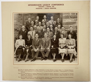 Melbourne Legacy
Photograph, Frank Boase, Intermediate Legacy Conference, Adelaide, Easter 1948, 1948
A photo of the delegates and senior observers of the Intermediate Legacy Club Conference held in Adelaide during Easter 1948. The attendees came from different cities, including Melbourne, Hobart, Geelong, Perth, Sydney, Newcastle, Adelaide and Brisbane. The names include: R Cumming, E Brown, H B Murn, A Lawson, C J Merefield, L Rolls, E B Hills, K Trevaskis, C Lee, J Yeates, V A Poulson, C Dodd, F Halliday, H H Kirkwood, R A Rowe, S Deverell, W McDougall, K Bremner, R Gammon, J Byrne, W A Ford, J Couch, B Roston, A Gale, J D Harvey, B Fennell, T Rowatt, J Murray, M Mead. Background: The ILC was formed in 1929 with a total membership of 18. The idea of the club sprang from those boys who had outgrown the Junior Legacy Club. In the early days it fielded a lacrosse team and it was this that mainly held the members together. Enthusiasm wained after a few years as it lacked a solid objective. The answer came from one of its members and in 1938 they founded the Don Esses Club. This was a club for the children of incapacitated ex-servicemen which met every Thursday night at 7.30 run by the ILC members. The name came from the signallers' code Disabled Servicemen's Sons. During the second world war 80% of the members of the ILC enlisted in the services. Leaving only 8 members that could not join due to ill health or reserved occupations. They continued the Don Esses and whatever aid they could to Legacy. ILC members had always helped Legacy where possible including being camp leaders or camp staff, with the annual demonstrations, and coffee stalls at the ANZAC dawn service. Post second world war some ILC members were nominated into Legacy, others drifted away in civil occupations. It was found difficult to recruit new blood into the ILC and eventually membership waned when the boys from the Don Esses clubs found other youth activities to join. The ILC ceased to meet regularly in the mid fifties. However a strong comradeship still existed between members and they would meet in one anothers homes. Members were always ready to help the senior Legacy Club in any way in their power and still helped at Christmas parties and summer camps. ILC was a service rendering organisation and was self governing. Non-sectarian and non-political, the members were ex-junior legatees over 18 years of age. After serving in World War 2 members were eligible to become members of Legacy.A record of an intermediate Legacy Conference in 1948. Junior Legatees who had achieved the age of 16 were forming intermediate clubs to further Legacy's work.Black and white photo of an ILC conference mounted on a buff colour board with brown text of the event and names of those in the photo.Back Row: R Cumming (Melbourne), E Brown (Melbourne), H B Murn (Hobart), A Lawson (Melb), C J Merefield (Brisbane). Second Row: L Rolls (Melbourne), E B Hills (Newcastle), K Trevaskis (Geelong), C Lee (Perth), J Yeates (Sydney), V A Poulson (Brisbane). Third Row: C Dodd (Sydney), F Holliday (Melbourne), H H Kirkwood (Advisor, Adelaide), R A Rowe (Hobart), S Deverell (Adelaide), W McDougall (Adelaide), K Bremner (Adelaide), R Gammon (Geelong), J Byrne (Adelaide), W A Ford (Perth), J Couch (Brisbane). Front Row: B Roston (Adelaide), A Gale (Minute Secretary, Adelaide), J D Harvey (Chariman, Adelaide), B Fennell (Secretary, Adelaide), T Rowatt (Brisbane), J Murray (Sydney), M Mead (Adelaide). Photographer 'Frank Boase '.ilc, junior legatee, conference -
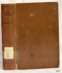 Flagstaff Hill Maritime Museum and Village
Book - Maritime Novel, Joseph Conrad, The Rover, 1923
This book was written by the renowned maritime author Joseph Conrad. Joseph Conrad was Polish-born and became a British subject in 1886. He was a renowned marine fiction writer and also, for a short time, a mariner and Captain. As a boy of 13 years old, Joseph Conrad’s desire was to be a sailor. At 19, he joined the British merchant marine, working in several roles. He eventually qualified as a captain but only served in this role once, from 1888-89, when he commanded the barque Otago sailing from Sydney to Mauritius. In 1889 he also began writing his first novel, Almayer’s Folly. He retired from life as a mariner in 1894, aged 36. Conrad’s visits to Australia from 1878 to 1982, and his affection for Australia, were later commemorated by a plaque in Circular Quay, Sydney. Conrad continued as an author. It is said that many of the characters in his books were inspired by his maritime experiences and the people he had met. By the end of his life, he had completed many stories and essays, and 19 novels, plus one incomplete novel titled ‘Suspense’ that was finished and published posthumously. Shortly before he passed away, in 1924, Conrad was offered a Knighthood by Prime Minister Ramsay MacDonald for his work but declined. An 1882 sailing ship, Georg Stage, was a Danish training ship, in which after a tragic accident 22 boys lost their lives. It was later renamed the Joseph Conrad by Alan Villiers in honour of the author. It continued as a training ship with various organisations until 1947 when it ship was transferred to the Mystic Seaport for use as an exhibit in the maritime museum. About the Pattison Collection: - The Pattison Collection is a group of books and records that was originally owned by the Warrnambool Mechanics’ Institute, (WMI) which was founded in Warrnambool in 1853. In 1935 Ralph Pattison was appointed as City Librarian to establish and organise the Warrnambool Library as it was then called. When the WMI building was pulled down in 1963 a new civic building was erected on the site and the new Warrnambool Library, on behalf of the City Council, took over all the holdings of the WMI. At this time some of the items were separated and identified as the ‘Pattison Collection’, named after Ralph Pattison. Eventually, the components of the WMI were distributed from the Warrnambool Library to various places, including the Art Gallery, Historical Society and Flagstaff Hill. Later some were even distributed to other regional branches of Corangamite Regional Library and passed to and fro. It is difficult now to trace just where all of the items have ended up. The books at Flagstaff Hill Maritime Village generally display stamps and markings from Pattison as well as a variety of other institutions including the Mechanics’ Institute itself. The book is significant for its connection with the renowned maritime author Joseph Conrad. It is also important for being part of the historic group of books called the Pattison Collection, along with other items at Flagstaff Hill Maritime Village, which was originally part of the Warrnambool Mechanics' Institute’s collection. The Warrnambool Mechanics’ Institute Collection is primarily significant in its totality, rather than for the individual objects it contains. Its contents are highly representative of the development of Mechanics' Institute libraries across Australia, particularly in Victoria. A diversity of publications and themes has been amassed, and these provide clues to our understanding of the nature of and changes in the reading habits of Victorians from the 1850s to the middle of the 20th century. The collection also highlights the Warrnambool community’s commitment to the Mechanics’ Institute, reading, literacy and learning in the regions, and proves that access to knowledge was not impeded by distance. These items help to provide a more complete picture of our community’s ideals and aspirations. The Warrnambool Mechanics Institute book collection has historical and social significance for its strong association with the Mechanics Institute movement and the important role it played in the intellectual, cultural and social development of people throughout the latter part of the nineteenth century and the early twentieth century. The collection of books is a rare example of an early lending library and its significance is enhanced by the survival of an original collection of many volumes. The Warrnambool Mechanics' Institute’s publication collection is of both local and state significance. The Rover Author: Joseph Conrad Publisher: T Fisher Unwin Date: 1923 Further Information: overseas editionThe label on the spine cover with typed text PAT FIC CON Paste down front end paper has a sticker from Warrnambool Mechanics Institute and Free Library covered by a sticker from Corangamite Regional Library Service. Front loose end paper has a stamp from Corangamite Regional Library Service.flagstaff hill, flagstaff hill maritime museum and village, warrnambool, maritime museum, maritime village, great ocean road, shipwreck coast, joseph conrad, captain joseph conrad, maritime author, marine author, nautical author, sailor, seafarer, georg stage, 1882 ship, danish ship, training ship, boys killed, alan villiers, ship joseph conrad, mystic seaport, museum ship, warrnambool mechanics institute, pattison collection, warrnambool library, ralph eric pattison, corangamite regional library service, the rover -
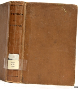 Flagstaff Hill Maritime Museum and Village
Book - Maritime Novel, Joseph Conrad, Typhoon and other Stories, 1924
This book was written by the renowned maritime author Joseph Conrad. Joseph Conrad was Polish-born and became a British subject in 1886. He was a renowned marine fiction writer and also, for a short time, a mariner and Captain. As a boy of 13 years old, Joseph Conrad’s desire was to be a sailor. At 19, he joined the British merchant marine, working in several roles. He eventually qualified as a captain but only served in this role once, from 1888-89, when he commanded the barque Otago sailing from Sydney to Mauritius. In 1889 he also began writing his first novel, Almayer’s Folly. He retired from life as a mariner in 1894, aged 36. Conrad’s visits to Australia from 1878 to 1982, and his affection for Australia, were later commemorated by a plaque in Circular Quay, Sydney. Conrad continued as an author. It is said that many of the characters in his books were inspired by his maritime experiences and the people he had met. By the end of his life, he had completed many stories and essays, and 19 novels, plus one incomplete novel titled ‘Suspense’ that was finished and published posthumously. Shortly before he passed away, in 1924, Conrad was offered a Knighthood by Prime Minister Ramsay MacDonald for his work but declined. An 1882 sailing ship, Georg Stage, was a Danish training ship, in which after a tragic accident 22 boys lost their lives. It was later renamed the Joseph Conrad by Alan Villiers in honour of the author. It continued as a training ship with various organisations until 1947 when it ship was transferred to the Mystic Seaport for use as an exhibit in the maritime museum. About the Pattison Collection: - The Pattison Collection is a group of books and records that was originally owned by the Warrnambool Mechanics’ Institute, (WMI) which was founded in Warrnambool in 1853. In 1935 Ralph Pattison was appointed as City Librarian to establish and organise the Warrnambool Library as it was then called. When the WMI building was pulled down in 1963 a new civic building was erected on the site and the new Warrnambool Library, on behalf of the City Council, took over all the holdings of the WMI. At this time some of the items were separated and identified as the ‘Pattison Collection’, named after Ralph Pattison. Eventually, the components of the WMI were distributed from the Warrnambool Library to various places, including the Art Gallery, Historical Society and Flagstaff Hill. Later some were even distributed to other regional branches of Corangamite Regional Library and passed to and fro. It is difficult now to trace just where all of the items have ended up. The books at Flagstaff Hill Maritime Village generally display stamps and markings from Pattison as well as a variety of other institutions including the Mechanics’ Institute itself. The book is significant for its connection with the renowned maritime author Joseph Conrad. It is also important for being part of the historic group of books called the Pattison Collection, along with other items at Flagstaff Hill Maritime Village, which was originally part of the Warrnambool Mechanics' Institute’s collection. The Warrnambool Mechanics’ Institute Collection is primarily significant in its totality, rather than for the individual objects it contains. Its contents are highly representative of the development of Mechanics' Institute libraries across Australia, particularly in Victoria. A diversity of publications and themes has been amassed, and these provide clues to our understanding of the nature of and changes in the reading habits of Victorians from the 1850s to the middle of the 20th century. The collection also highlights the Warrnambool community’s commitment to the Mechanics’ Institute, reading, literacy and learning in the regions, and proves that access to knowledge was not impeded by distance. These items help to provide a more complete picture of our community’s ideals and aspirations. The Warrnambool Mechanics Institute book collection has historical and social significance for its strong association with the Mechanics Institute movement and the important role it played in the intellectual, cultural and social development of people throughout the latter part of the nineteenth century and the early twentieth century. The collection of books is a rare example of an early lending library and its significance is enhanced by the survival of an original collection of many volumes. The Warrnambool Mechanics' Institute’s publication collection is of both local and state significance.Typhoon and other Stories Author: Joseph Conrad Publisher: William Heinemann Ltd Date: 1924 Further Information: contents Typhoon, Amy Foster, Flak: A Reminiscence and To-morrowThe label on the spine cover with typed text PAT FIC CON Pastedown front endpaper has a sticker from Warrnambool Public Library covered by a sticker from Corangamite Regional Library Service. The front loose endpaper has a stamp from Corangamite Regional Library Service.flagstaff hill, flagstaff hill maritime museum and village, warrnambool, maritime museum, maritime village, great ocean road, shipwreck coast, joseph conrad, captain joseph conrad, maritime author, marine author, nautical author, sailor, seafarer, georg stage, 1882 ship, danish ship, training ship, boys killed, alan villiers, ship joseph conrad, mystic seaport, museum ship, warrnambool mechanics institute, pattison collection, warrnambool library, ralph eric pattison, corangamite regional library service, typhoon and other stories -
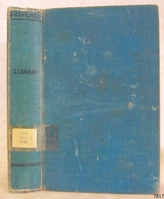 Flagstaff Hill Maritime Museum and Village
Book - Maritime Novel, Joseph Conway, Suspense, 1925
This book was written by the renowned maritime author Joseph Conrad. Joseph Conrad was Polish-born and became a British subject in 1886. He was a renowned marine fiction writer and also, for a short time, a mariner and Captain. As a boy of 13 years old, Joseph Conrad’s desire was to be a sailor. At 19, he joined the British merchant marine, working in several roles. He eventually qualified as a captain but only served in this role once, from 1888-89, when he commanded the barque Otago sailing from Sydney to Mauritius. In 1889 he also began writing his first novel, Almayer’s Folly. He retired from life as a mariner in 1894, aged 36. Conrad’s visits to Australia from 1878 to 1982, and his affection for Australia, were later commemorated by a plaque in Circular Quay, Sydney. Conrad continued as an author. It is said that many of the characters in his books were inspired by his maritime experiences and the people he had met. By the end of his life, he had completed many stories and essays, and 19 novels, plus one incomplete novel titled ‘Suspense’ that was finished and published posthumously. Shortly before he passed away, in 1924, Conrad was offered a Knighthood by Prime Minister Ramsay MacDonald for his work but declined. An 1882 sailing ship, Georg Stage, was a Danish training ship, in which after a tragic accident 22 boys lost their lives. It was later renamed the Joseph Conrad by Alan Villiers in honour of the author. It continued as a training ship with various organisations until 1947 when it ship was transferred to the Mystic Seaport for use as an exhibit in the maritime museum. About the Pattison Collection: - The Pattison Collection is a group of books and records that was originally owned by the Warrnambool Mechanics’ Institute, (WMI) which was founded in Warrnambool in 1853. In 1935 Ralph Pattison was appointed as City Librarian to establish and organise the Warrnambool Library as it was then called. When the WMI building was pulled down in 1963 a new civic building was erected on the site and the new Warrnambool Library, on behalf of the City Council, took over all the holdings of the WMI. At this time some of the items were separated and identified as the ‘Pattison Collection’, named after Ralph Pattison. Eventually, the components of the WMI were distributed from the Warrnambool Library to various places, including the Art Gallery, Historical Society and Flagstaff Hill. Later some were even distributed to other regional branches of Corangamite Regional Library and passed to and fro. It is difficult now to trace just where all of the items have ended up. The books at Flagstaff Hill Maritime Village generally display stamps and markings from Pattison as well as a variety of other institutions including the Mechanics’ Institute itself.The Pattison Collection, along with other items at Flagstaff Hill Maritime Village, was originally part of the Warrnambool Mechanics' Institute’s collection. The Warrnambool Mechanics’ Institute Collection is primarily significant in its totality, rather than for the individual objects it contains. Its contents are highly representative of the development of Mechanics' Institute libraries across Australia, particularly Victoria. A diversity of publications and themes has been amassed, and these provide clues to our understanding of the nature of and changes in the reading habits of Victorians from the 1850s to the middle of the 20th century. The collection also highlights the Warrnambool community’s commitment to the Mechanics’ Institute, reading, literacy and learning in the regions, and proves that access to knowledge was not impeded by distance. These items help to provide a more complete picture of our community’s ideals and aspirations. The Warrnambool Mechanics Institute book collection has historical and social significance for its strong association with the Mechanics Institute movement and the important role it played in the intellectual, cultural and social development of people throughout the latter part of the nineteenth century and the early twentieth century. The collection of books is a rare example of an early lending library and its significance is enhanced by the survival of an original collection of many volumes. The Warrnambool Mechanics' Institute’s publication collection is of both local and state significance. Suspense Author: Joseph Conrad Publisher: J M Dent & Co Date: 1925 Introduction by Richard Curle Blue hardcover with inscription on sticker on spine and a purple stamp on the fly pageLabel on spine, typed text "PAT 823.9 CON" Pastedown front endpaper has sticker from Warrnambool Public Library covered by a sticker from Corangamite Regional Library Service Front loose endpaper has a stamp from Corangamite Regional Library Serviceflagstaff hill, flagstaff hill maritime museum and village, warrnambool, maritime museum, maritime village, great ocean road, shipwreck coast, joseph conrad, captain joseph conrad, maritime author, marine author, nautical author, sailor, seafarer, georg stage, 1882 ship, danish ship, training ship, boys killed, alan villiers, ship joseph conrad, mystic seaport, museum ship, warrnambool mechanics institute, pattison collection, warrnambool library, ralph eric pattison, corangamite regional library service, suspense, unfinished book -
Eltham District Historical Society Inc
Document - Folder, Skipper, Matchem
Matcham Skipper was born in New Zealand in 1921 to Lena and Mervyn Skipper. The family returned to Australia. After Mervyn met Justus Jorgensen; they moved to live at Montsalvat. Matcham married Myra Gould; he became a sculptor and jewellery maker. Contents Newspaper photograph: "The artist at work - Matcham Skipper in his studio at Montsalvat", The Australian, 10 August 1966. Matcham Skipper working on a metal artwork. Photocopy of photograph: Matcham Skipper c1970. Magazine article: "Matcham Skipper - knockabout genius", POL vol.4 no.12 (~1972). Biography of Matcham Skipper. Magazine photograph: "Skipper and his home. He helped to lay the bricks", no source or date. Magazine photograph: "Matcham Skipper, of Eltham, works on his sculpture of Leda and the Swan, which will be presented to this year's winner of the David Jones fashion award", no source or date. Newspaper article: "Ageless quality before fashion", Diamond Valley News, 19 December 1883. Matcham Skipper included in exhibition of jewellers at Eltham Gallery. Newspaper photograph: "Mr Matchem Skipper puts the finishing touhes to the steel mandala yesterday", no source or date. Newspaper article: "Metallic influence of Renaissance sculptor", Diamond Valley News, ~1982. Biography of Matcham Skipper. Newspaper article: "A Matcham Skipper monologe", The Age Saturday Extra, 31 August 1985. Matcham Skipper's year in Italy. Newspaper article: "Office regalia", Diamond Valley News, 14 August 1990. Presentation of Eltham Shire mayoral chain made by Matcham Skipper. Newspaper article: "Old flicks on big screen", no source, 2004. Exhibition of Matcham Skipper's photographs "The Arnham Land Portraits" to accompany screening of Tim Burstall films. Newspaper article: "No match for Skipper", Diamond Valley News, 3 November 2010. Matcham Skipper's sculpture of a boy "Young man awakening" for Eltham Cemetery Trust. Newspaper article: "Final salute to Skipper", Diamond Valley Leader, 2 March 2011. Death of Matcham Skipper. Newspaper death and funeral notices: Matcham Skipper, so source or date. Newspaper article: "Remembering Matcham", Diamond Valley Leader, 9 March 2011. Funeral of Matcham Skipper at Montsalvat. Letter Eltham District Historical Society to Sigmund Jorgensen, 13 March 2011, seeking copies of eulogies given by Sigmund Jorgensen and Clio Skipper at funeral of Matcham Skipper. Letter Sigmund Jorgensen to Eltham District Historical Society, 21 March 2011, enclosing edited version of the eulogy with illustrations of work of Matcham Skipper. Newspaper obituary: "Eltham art colony's knockabout genius", The Age 31 March 2011. Obituary of Matcham Skipper. Newspaper clippings, A4 photocopies, etcmatcham skipper, myra skipper nee gould, marcus skipper, adam skipper, damion skipper, montsalvat, lena skipper, mervin skipper, justus jorgensen, karel zoubek, david jones fashion awards, eltham gallery, gerd bahmann, heidi wild, gilliam hillman, sonia skipper, pietrasanta, luigitommasi fonderia d'arte, peter graham, bob mclellan, thelma mclellan, tim burstall, the prize (film), the arnham land portraits exhibitio, eltham cemetery trust, jenardiy zabenko, craig macdonald, "young man awakening" sculpture, sigmund jorgensen, sue thomas, simon skipper, helen skipper, glen tomasetti, sandy kilpatrick, clio (sarah) tomasetti, raphael kilpatrick, alan marshall, alistair knox, clifton pugh, tony raunic, rita wooley, erasmus toscano, maurice toscano, mervyn garnham skipper -
 Mission to Seafarers Victoria
Administrative record (item) - Annual report, Clarke & Co. Printers, Forty-Second Annual Report of the Victorian Seamen's Mission, 1899, 1900
The reports were produced and readily distributed annually to a number of organisational stakeholders and included reports from the Committee, Chaplain, extracts of letters, Ladies auxiliary and a list of subscribers. In the Argus (Melbourne, Vic. : 1848 - 1957), Saturday 24 February 1900, page 15: VICTORIAN SEAMEN'S MISSION The annual meeting of the Victorian Seamen's Mission was held in the institute at Port Melbourne last night. There was a fair attendance, the large proportion being ladies, and the chair was occupied by Sir Frederick Sargood MLC. Mr Hugh R Reid, the president of the institute, was also president. The annual report, which was lead and adopted, stated that the Seamen's Institute at Port Melbourne, and also the Sailors' Rest at Williamstown, had sustained their reputation for usefulness and attractiveness. The attendances had been very large at each place and 114 seamen had taken the pledge at the Port Melbourne Institute. Regreat was felt that owing to the preliminary steps having met with opposition in Parliament the building of the long contemplated additional institute near the Melbourne wharves was deferred but the project had not been abandoned. Large parcels of literature had been distributed gratuitiously among ships' crews and the concerts held for the entertainment of seamen had been very successful. The mission had been in existence for over 40 years. It aimed at promoting the temporal and spiritual welfare of seamen. It had been the means of completely eradicating "crimping" and the sailors' "boarding masters" curie, and otherwise removing many of the abuses which still exist in other ports. The Chairman, in moving the adoption of the report and balance sheet, referred to the great benefits which seamen derived from the institute. He was particularly struck by the fact that during the past year close on 2,000 letters had been written by visiting seamen from the institute namely, 1,720 at Port Melbourne, and 261 at Williamstown. It was also a very note-worthy feature, which perhaps the residents of Williamstown might be able to explain that, whilst out of 49,567 attendances at the Port Melbourne institute 114 had taken the pledge there, there was not a single instance on record of the pledge having been taken at the Sailors' Rest, Williamstown, out of 8,218 attendances. (Laughter) Referring to the projected new institute near the wharves, he was amazed to find that its construction had been, according to the report, orefused by some of the labour members. He did not know the details of the matter, but was of opinion that there was no institution more deserving of the support of labour members than the one advocated. In his opinion, the representatives of labour should disown the action of their delegates in Parliament in this matter. (Cheers ) Selections of vocal and instrumental music were given during the evening.These reports were produced annually and include a number of smaller reports from the Executive Committee, Chaplain and auxiliary. They sometimes included photographs and a list of subscribers and amounts pledged. These reports provide an organisational overview as well as many stories of the people who populated the Mission to Seafarers.Handwritten in ink on top right hand corner: "F T Derham [indecipherable]" Handwritten in ink on bottom left hand corner: "Melbourne Sailors' Home" Cover back page written in black ink: W. Siddley Esq. / 529 Collins Street / Melbourneannual report, 1899, victorian seamen's mission, port melbourne, williamstown, sailors' rest, seamen's mission, mission to seafarers, seamen's institute, sailors' home, f.t. derham, reverend ebenezer james, whc darvall, frederick sargood, hugh r. reid, administrative document-annual report -
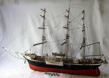 Flagstaff Hill Maritime Museum and Village
Craft - Ship Model, Joseph Conrad, 20th century
The ship model of the Joseph Conrad represents the craft of ship model making, which has been enjoyed by many people over the years. Although the model is made from modern materials, it shows the elements of a sailing ship of a bygone era. About the sailing ship JOSEPH CONRAD: - The vessel Joseph Conrad began as the Danish iron-hulled sailing ship Georg Stage, launched in 1882. It was used as a training ship for Danish sailors. In 1905, while docked in Copenhagen, the ship was rammed by a larger ship, and 22 boys were killed while sleeping in the hull. The ship was later raised and on guard during World War I. Alan Villiers was an Australian author of seafaring books as well as a sailor. He bought the wooden sailing ship George Stage and renamed it Joseph Conrad in honour of the renowned Polish-born maritime author and once the captain of the barque Otago. In 1934 Villers sailed the ship on a two-year voyage around the world. In 1936, it was sold to an American, who later donated it for use again as a training ship. After World War II the ship was no longer used, and in 1947 it was transferred to the Mystic Seaport Museum for training use again as well as an exhibit. JOSEPH CONRAD (1857-1927): - Joseph Conrad was Polish-born and became a British subject in 1886. He was a renowned marine fiction writer and also, for a short time, a mariner and Captain. As a boy of 13 years old, Joseph Conrad desired to be a sailor. At 19, he joined the British merchant marines, working in several roles. He eventually qualified as a captain but only served in this role once, from 1888-89, when he commanded the barque Otago sailing from Sydney to Mauritius. In 1889 he also began writing his first novel, Almayer’s Folly. He retired from life as a mariner in 1894, aged 36. Conrad’s visits to Australia from 1878 to 1982, and his affection for Australia, were later commemorated by a plaque in Circular Quay, Sydney. Conrad continued as an author. It is said that many of the characters in his books were inspired by his maritime experiences and the people he had met. By the end of his life, he had completed many stories and essays, and 19 novels, plus one incomplete novel titled ‘Suspense’ that was finished and published posthumously. Shortly before he passed away, in 1924, Conrad was offered a Knighthood by Prime Minister Ramsay MacDonald for his work but declined the offer. The ship model represents the design of sailing ships built in the 1880s and can be used as a reference in understanding the construction of the ships of the Victorian era. The model is important for its connection to the vessel Joseph Conrad which was used as a training ship for seafarers, and even now is used to teach maritime skills, as well as an exhibit, in the maritime museum, Mystic Seaport. The model's name is significant for its association of its name with the famed early 20th-century maritime author, Joseph Conrad.Ship model; A three-masted sailing ship named the Joseph Conrad, with cabins on deck, lifeboats, a ladder on the side and a figurehead on the bow. The hull is black at the top and red below. The ship's name is painted on both sides of the bow. JOSEPH CONRADflagstaff hill, flagstaff hill maritime museum and village, warrnambool, maritime museum, maritime village, great ocean road, shipwreck coast, joseph conrad, captain joseph conrad, maritime author, marine author, nautical author, sailor, seafarer, ship model, two-masted ship, iron hull, sailing ship, georg stage, 1882 ship, danish ship, training ship, boys killed, alan villiers, ship joseph conrad, mystic seaport, museum ship, otago -
Eltham District Historical Society Inc
Document - Folder, Masefield, Bert and Ethel
Bert Masefield's parents came from Lancashire to Surrey Hills, his education ending because of the depression when he went to work at an orchard at Hastings. When his father list his job as a cabinet maker, he bought an orchard at Cottlesbridge and Bert joined them, ploughing with a horse. He met and married Ethel Smith who had grown up at Panton Hill; her great grandparents Sarah and Samuel Smith came from Lancashire where they had a cotton mill and iron foundry, settling at Smith Gully between Panton Hill and St Andrews. Their son Edwin married Louisa Purcell whose parents owned the Caledonie Hotel at Smiths Gully; they had 12 children and settled on a property in Cherrytree Road. Son Edwin left Panton Hill school aged 11 in 1885 and worked with his father and uncle fencing the family property. Edwin had nine children, Ethel being the seventh. Aged 14, she gained a scholarship to Stotts Business College. Berth and Ethel, when they married, bough a property in Cherrytree Road. In 1941 Bert, a ham radio enthusiast, joined the RAAF as a radio mechanic, serving in Townsville and New Guinea until 1945. Over time, they subdivided their property. Bert worked for ten years as property officer for Eltham Shire Council; his work included coverting Three Chain Road (or Gumtree Road) into a huge firebreak. Now retired, Bert spends time speaking with radio operators around the world and the couple are involved with sports including the Montmorency Bowling Club; they were foundation members of the Hurstbridge Bowling Club. Marjorie North (nee Cooper) was 14 when her family moved from the city to Montmorency when the railway station was first built in 1923. Marjorie described her memories of Montmorency at that time. She and sister Connie were keen tennis players, playing at Greensborough. By 1927, they had arranged, though shire engineer Ben Johnson, to rent land from the Council for 10 pounds a year; Mr Paragreen levelled the land. The club held a dance every three weeks in a school room with piano for music. She won the singles, doubles and mixed doubles championships in 1929 at the first championship. Contents Newspaper article: "Round the world on radio waves," Diamond Valley News, 30 September 1986, outlines Bert and Ethel Masefield's lives. Newspaper article: "Stalwart recalls the early days," Diamond Valley News, 30 September 1986, outlines Bert and Ethel Masefield's lives.Newspaper clippings, A4 photocopies, etcbert masefield, elthel masefield, ethel smith, cherrytree road panton hill, samuel smith, sarah smith, smith gully victoria, caledonie hotel smiths gully, stotts business college, montmorency bowling club, hurstbridge bowling club, eltham shire council, edwin smith, louisa purcell, parragreen of para road, ben johnson, montmorency tennis club -
 Bendigo Historical Society Inc.
Memorabilia - GOLD NUGGET COLLECTION: THE PLATYPUS
A plaster replica of the 377 ozs gold nugget that was discovered in March 1861 in Robinson Crusoe valley at a depth of 5 feet by Mr John Knott and his son. It was the largest nugget found on the field. Value in 2016 $595,463. An article by the Bendigo Advertiser on Saturday 16 March 1861 describes the discovery "One of the largest pieces of gold that have been turned out of the ground on Bendigo, was yesterday brought to light in a small gully called Dead Bullock Gully, on the Kangaroo Flat side of Robinson Crusoe. The fortunate discoverers of the treasure are in this instance, as is generally the case, "fossickers," and where the nugget was found is in some old ground that has no doubt been turned over times innumerable within a few feet of the spot where the prize was lying hid. The exact weight of the nugget is 377 oz 6¾ dwts of as pure gold as ever came out of the ground. The finders are Mr John Knott and his son; the latter,a lad, being the party who actually found it, which he did under rather peculiar circumstances. He was down below in the old hole, putting a drive into an old pillar that had been left, when he drove his pick into the mass of gold, and partially discovered it. Under the excitement of the moment he cried out loudly, and his father, who was on top, immediately jumped down the hole, under the impression that his son had met with an accident, but fortunately found that he only required assistance in extracting the welcome stranger. The following is a description of the nugget. Length, twelve inches; width, six; while in some places it is of about two inches in thickness, in others it is only about half an inch. It has that peculiarity of form which from the days of the early finders of nuggets has enabled one to discover a resemblance to something either common or uncommon. We have had nuggets resembling frying pans, legs of mutton, dampers, and other articles in use in the rosy days of the diggings. In the present instance several parties who have seen the nugget assert that both in shape and size it is very much like an Australian Platypus, one of the ends of the nugget being exactly in formation like the snout of the animal. It will be exhibited today in the gold office of Mr Bannerman, and will, no doubt,attract the gaze of a crowd. Mr Knott states that at breakfast, before going to work in the morning, the boy mentioned to his mother that he had dreamt on the previous night that he would find a large nugget. May the similar dreams of every alluvial miner come as true as this realization of a prize worth between fourteen and fifteen hundred pounds in value."It has a sticker on it that says 'The Platypus 112'mining, models, plaster model of victorian gold nugget, https://trove.nla.gov.au/newspaper/article/87375584