Showing 2605 items matching "2018"
-
 Warrnambool and District Historical Society Inc.
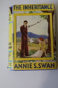
Book, The Inheritance
A novel for young girlsThis is a book of 326 pages. It has a dust cover, partly torn, with an illustration of a man and a woman on a yellow background on the front cover. The spine of the dust cover is yellow with black printing and there is blue printing on the front cover and black printing on the back cover. The hard cover is blue with black printing. The pages contain black printed text. There is a book plate on the inside front coverfictionA novel for young girlswarrnambool baptist church, sacks jewellers warrnambool, audrey sack -
 Ringwood and District Historical Society
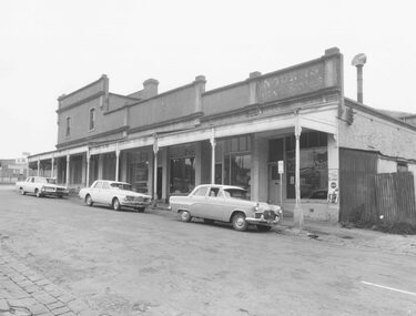
Photographs, Block Buildings, Adelaide St Ringwood before demolition for Eastland 1965
Set of 11 Black and White photos of the Block Buildings corner Adelaide St and Maroondah Hwy, Ringwood. Taken for Court - site inspection by Mr Justice Barber 6.8.1965. Part of the Eastland Compensation Litigation (See Reference below). (Renamed and recatalogued into this one item 2018). 381A: Adelaide St Shops 381B: Rear of Coffee Palace, Maroondah Hwy 381C: Adelaide Street Shops 381D: Side and Rear of Renong Chambers, cnr Civic Place and Adelaide ST 381E: Renong Chambers Adelaide St. )Reynolds Fish and Chip shop on ground floor) 381F: Back of the Coffee Palace 381G: Rear of Adelaide St Shops, off Civic Place. cf SS038k (Record #2832). Taken from Civic Place 381H: Maroondah Hwy, looking towards Adelaide St 381I: Cnr Maroondah Hwy and Adelaide St 381J: Old House, taken from laneway now Civic Place 381K: Coffee Palace, Maroondah HwyStamped on back: Peter Payens of Ringwood Studios. 86 Whitehorse Road, Ringwood -
 Bendigo Historical Society Inc.
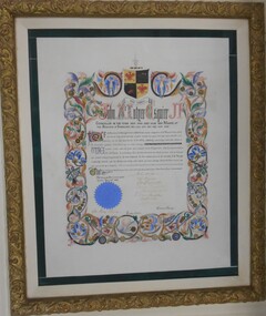
Award - ILLUMINATED ADDRESS :JOHN MCINTYRE ESQUIRE, 24/04/1868
Illuminated Address given to John McIntyre Esquire for his time in the Bendigo City Council in the years 1859 - 1860 - 1862 and Mayor of the Borough of Sandhurst: 1863, 1864, 1865, 1866, 1867, 1868. Signed by Councillors, John Holmes, Robert Burrowes, George Aspinall, James Boyd. M.D., J. Holdsworth, D. Macdougal, Ed. Garsed, John Latham, Town Clerk, George Avery Fletcher. Coloured hand drawn artwork on outline of address.Crest Per Ardua. Crest 2 red phoenix on gold background, hand with dagger, ship with red flags on black background. On top of crest hand with dagger blue and white with gold and black ribbon underneath. Blue corporate seal. *Currently on Loan in the National Museum. Loan extended till 31 May 2018. Loan Number IL 2010/0074, File No. 09/1062. Updated April 2016 Returned from National Museum 29.6.2018 * on the certificate John McIntyre's name appears to be John McIntyrr Esqirrartwork, illuminated address, 364/1 -
 Melbourne Tram Museum
Newspaper, The Age, “'Time bomb': Caught out with an expired myki”, "The tap-on taps into some new tech", "'Myki miracle' eludes Apple users", 24/01/2019 12:00:00 AM
Newspaper clippings titled: 1. “'Time bomb': Caught out with an expired myki” - the Age 24/1/2019 Timna Jacks Transport reporter Mike Smith is contesting fine for using expired myki on tram on Route 57 in May 2018. Mr Smith is taking PTV to court to contest the fine. 2. "The tap-on taps into some new tech" - the Age 7/2/2019 Tom Cowie Trialling new smartphone technology on trams and trains. Photo shows Nick Neos using Android phone to tap on myki validator on a tram. 3. "'Myki miracle' eludes Apple users" Android smartphone users will be able to pay for public transport fares from 7am on Thursday 28 March 2019 but Apple iPhone users will have to wait. Apple locks down the NFC chip so that it can only be used by Apple apps. Until an iPhone can mimic a myki card, iPhone users can't use the system.trams, tramways, route 57, newmarket, myki -
 Melbourne Tram Museum
Administrative record - Depot List, Australian Electric Traction Association (AETA), "Allocation of Tramcars as at 28. 2.1982", Feb. 1982
Foolscap photocopied document, 6 sheets, stapled in top left hand corner, titled "Allocation of Tramcars as at 28 Feb. 1982", listing the class of trams allocated to each depot in Melbourne, MMTB, training trams, storage, special purpose trams, summary. Has been photocopied onto foolscap sheet - and published as a supplement to E.T 4/82. 2nd copy added 13-6-2016 from the estate of Charles Craig. 469.1 - As above, but with additional notes in red showing changes, in particular stored trams. See htd469i2.pdf. 469.2 - 10 A4 sheets - original workshops document. Sheets 1 to 3 - numerical order including to tram 191 including notes on storage. Sheets 4 to 8 - by depot, including notes on Training Trams, Tourist Trams and Miscellaneous trams. Sheet 9 - distribution list Sheet 10 - Fleet summary in service and storage. 469.1 and 469.2 from donation of Norm Cross added 26-9-2018trams, tramways, preston workshops, lists, tramcars, mmtb, lists, depots, depot allocation -
 Melbourne Tram Museum
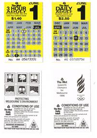
Ephemera - Ticket/s, The Met, Set of 10, The Met, Zone 1 Daily Adult Scratch tickets, 1989
.1 -Set of 10, The Met, Zone 1 Daily Adult Scratch type tickets, $2.50, yellow with black printing and areas where a person could scratch out the month and day of the month areas to validate the ticket. Has the number on the base of the ticket. Printed for use between December 1989 and July 1990. .2 - One 3 Hour Adult ticket - $1.40. On the rear are the conditions of travel for both types of tickets, The Met logos, Transport Information and Transit Patrol telephone numbers. Some of the tickets have a message, along with logos that The Met is supporting the bid for the Olympics in Melbourne 1996. Three additional 3 hour zone 1 Adult ticket - 1.40 added on 4/7/15, from the donation of Rod Atkins on 13/6/15. See also Reg Item Nos. 979, 1069, 1161, 4624 for other examples. .3 - Daily Concession - $1.30 - from Vic Solomons added 20-7-2018.trams, tramways, the met, scratch tickets, olympics -
 Phillip Island and District Historical Society Inc.
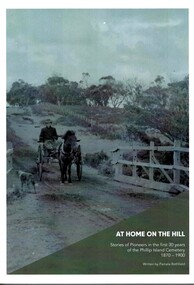
Book, At home on the hill - Stories of Pioneers in the first 30 years of Phillip Island cemetery 1870-1900 Written by Pamela Rothfield, 2018
Stories of the first 73 occupants of the Phillip Island Cemetery describing the lives and history of the early residents of Phillip Island. Written by a Cleeland descendant, Pamela Rothfield.HistoricalLarge, soft covered book with large black and white and coloured photos and text.ISNN 978-0-646-99552-6phillip island cemetery, genealogy, forrest, jenner, richardson, cleeland, dixon, mcgregor, reid, walton, west, cox, underdown, mcillwraith, woolcock -
 Bendigo Military Museum
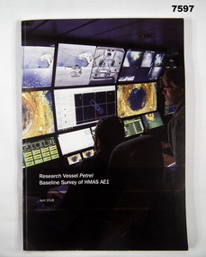
Book, Find AE1 Ltd & Australian National Maritime Museum, "RESEARCH VESSEL PETREL BASELINE SURVEY OF HMAS AE1", 2018
"Research Vessel Petrel - Baseline Survey of HMAS AE1" This book is a report of a comprehensive photographic survey completed on a c.1938 submarine wreck off the coast of PNG.Soft cover book. Cover - cardboard with white print on black and dark blue background on front and spine. Illustrated with colour photographs. Front cover - "RV Petrel control room during the survey". Back cover - "AE1 bow torpedo tube". 179 pages, cut, plain, white paper. Illustrated in black and white and colour photographs, maps and technical drawings.books, ww2, submarine, png, photographic -
 Bendigo Military Museum
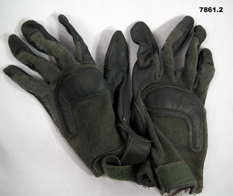
Accessory - GLOVES, COMBAT, ARMY, Nov 2018
Gloves - part of issue to all personnel in the field.Black leather gloves with some padding on the front and back. Back made of Army Green knitted material and adhesive straps on the wrists to tighten. Material hooks on each wrist. Label on right glove with description, size and cleaning instructions.Label says "Gloves, Combat Army Type 11, Capacitive then cleaning instructions. Size - medium.accessories, gloves -
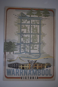 Warrnambool and District Historical Society Inc.
Document, Ella Webb, Warrnambool artist, Street Walks of Warrnambool, 2018
This is a tourist guide to Warrnambool produced by a local artist, Ella Webb, in conjunction with the Warrnambool and District Historical Society. It includes a sketch map showing the location of some points of interest – buildings and sites of historical interest, places of interest that are no longer existing, some natural features (mainly along the coast) and some information about incidents and people in the past. It is an attractive broadsheet that is a useful guide for visitors to Warrnambool. This sheet is of interest as a modern-day tourist map produced in an artistic fashion by a local Warrnambool artist.This is a single sheet of thick paper printed on both sides in green, brown, yellow and beige tonings. One side of the sheet has sketches of buildings and places of interest and printing and the other side has a sketch map of some of the main streets of Warrnambool and some of its attractions. -
 Warrnambool and District Historical Society Inc.
Book, Amazon Printing, William Francis Brebner 1880-1852, 2018
This book documents the lives of William and Agnes Brebner and family. William’s father, Isaac had come to Warrnambool in the 1860s and had a tailoring business in the town. By the beginning of the 20th century he was the caretaker at the Sea Baths in Gilles Street, Warrnambool and the family lived in the caretaker’s cottage (Les O’Callaghan History House today). William Brebner established a paint shop in Timor Street in 1916 and this prominent business remained in the Brebner family until 1977. It continued in other hands until the early years of the 21st century. This book is of significance as it documents the life and times of William Brebner and his family. The Brebners have been important, particularly in the 20th century, in the business and community world of Warrnambool.This is a soft cover book of 132 pages. It has a blue cover with a black and white photograph of William Brebner and black printing on the front cover. It has four sections – one on the life of William Brebner and his wife and family, one on his ancestors and two on his descendants. The book contains many black and white and colour photographs.brebner family,, history of warrnambool -
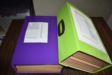 Warrnambool and District Historical Society Inc.
Documents (Bruce Morris), OfficeWorks Ltd Australia, distributors, 2018 (folders)
These folders contain the historical notes written by Bruce Morris in regard to the life story and achievements of George Lance. These notes were used by Bruce Morris to write a great number of historical articles on George Lance and these were mostly published in the Warrnambool Standard. Bruce Morris (1903-1986) was the editor of the Warrnambool Standard from 1946 to 1968. During that time he was prominent in community activities in Warrnambool and was well-known for the great number of historical articles he published in his paper, making him one of Warrnambool’s most important historians. George Lance, the subject of the notes in these folders, was Bruce Morris’ grandfather. George Lance (1933-1901) was a plumber particularly associated with the development and use of gas power in Warrnambool and the inventor of the Eureka Pump and the Lance Patent Cess Pan. He was also a writer of historical articles, a musician with the Warrnambool Artillery Band and an important artist in the town, with some of his works of art in the Warrnambool Art Gallery today. He is regarded as the person most responsible for the establishment of the Warrnambool Art Gallery in the 1880s. Bruce Morris’ notes include material on George Lance’s involvement with the Warrnambool Bowls Club, the School of Arts, the Mechanics’ Institute, the Baptist Church and the Manchester Unity Independent Order of Oddfellows.These folders are of considerable importance as they contain the historical notes of Bruce Morris regarding his grandfather, George Lance. Both Bruce Morris and George Lance are significant in Warrnambool’s history, the former as an important historian and newspaper editor and the latter as an inventor, writer, artist, musician and a person regarded as the 19th century founder of the Warrnambool Art Gallery .1 This is a lime-green rectangular-shaped folder made of stiffened cardboard with a black plastic handle on the top with a black plastic catch on the side. Inside the folder are paper inserts that fold up in concertina fashion. In the inserts are twelve blue plastic folders that contain handwritten and typed material. .2 This is a purple rectangular-shaped folder made of stiffened cardboard similar to .1 above. It has a black plastic handle on the top and a black plastic catch on the side. Inside the folder are paper inserts that fold up in concertina fashion. In the inserts are twelve blue plastic folders that contain handwritten and typed material. George Lance Folders. Bruce Morrisbruce morris, warrnambool, george lance, warrnambool, history of warrnambool -
 Eltham District Historical Society Inc
Photograph, Jim Connor, Eltham - Montmorency Uniting Church, 810 Main Rd, Eltham, 13 July 2018
jim connor collection, uniting church, 2018-07-13 -
 Eltham District Historical Society Inc
Photograph, Liz Pidgeon, Public Records Office Victoria (PROV) visit to Eltham Justice Precinct, 20 Apr 2018
The original Shire of Eltham was founded in 1871. Prior to its founding, the district was managed by the Eltham District Road Board, which was established in 1856. The initial rate assessment commenced in 1857 for the year ending October 14, 1858. The honour of being recorded with the first assessment went to a farm of 110 cultivated acres at Lower Plenty, owned by John Porter and occupied by Albert Baines. It was assessed at 6d/acre providing for a rate income of £2 15s. In July 2017, officers at Nillumbik Shire Council discovered some early Eltham Road District Assessment books and donated them to the Eltham District Historical Society. The seven volumes were the district’s first six years of rate assessments. This was a unique and significant record of early settlers in the pre-Shire of Eltham. They immediately became one of the oldest and most valuable items in our collection. An article on page 5 in the Eltham and Whittlesea Shires Advertiser, Friday, 21 November, 1941 titled: ‘District’s Early History‘ states: “The first rate book which is still in existence at the Shire Office is for the year ending October 14, 1858 and is probably the best record possible to indicate the development of the district. At the time properties were rated as follows: Cultivated land. 6d. per acre; pasture land, 1d. per acre: estimated annual value of buildings, etc., 6d in the (pound). The total amount of rate recorded for the year was £153/14/8. Properties were described as being situated at Lower Plenty, Yarra Yarra, Eltham, Lower Eltham, Kangaroo Ground, Yarra Flats, Diamond Creek and the Yarra.” Given the precious nature of this collection, priority was given to digitise the rate books and place them in suitable archival storage to minimise further handling. Subsequent discussion amongst our Collections team arrived at the conclusion that the most appropriate home for this valuable record was the Public Record Office Victoria (PROV), the archive of the State Government of Victoria and who are charged with archiving and caring for all Government related records. An approach was made to PROV who confirmed these records would complete their collection of rate assessment books for Eltham. At a small ceremony held Friday, April 20 at the Local History Centre, Eltham, members of the Society and our Collections team, along with Ms. Vicki Ward, MP for Eltham, presented the seven volumes for 1858-1863 along with the complete set of digital files to Mr. David Taylor, Community Archives Manager and Mr. Charlie Farrugia, Senior Collection Advisor, Public Record Office Victoria.Born Digitalassessment ledger, donation, eltham courthouse, eltham road district, local history centre, public records office victoria (prov), rate books, eltham district road board -
 Eltham District Historical Society Inc
Photograph, Officers in charge of Eltham Police Station (1857-2015), 22 Sep 2018
The first Eltham Police Station was in the small building opposite Dalton Street rented from Mr Jarrold in 1857. In 1859 a dedicated Police Residence was built at 728 Main Road. A small weatherboard Police Station was attached to the side of the residence and a blue stone cell at the rear. Also on site were stables for the police horses. The Eltham Courthouse was built in 1860 and is the oldest public building in the district. In 1959 the Victoria Police purchased a house in Pryor Street to be refurbished as the Eltham Police Station. In 1961 the Police in Eltham move into Pryor Street refurbished buildings and office. During 2001 to 2002, the Eltham Police Station was demolished and a new complex constructed on site. The original 1859 Police residence is now home to the Eltham District Historical Society.albert frederick charles glover, allan fenton, arthur eggleston dungey, bertie stanton, charles briant, charles thomas martin, clyne harold mcphan, ebenezer williamson, eltham police station, gerard joseph o'toole, graham vincent joyce, harold shields, ian william bruce, isaac newton stevens, james boxhall, james chester draper, john scully, john stanley mcgough, john stuart bateman, john thomas cone, myles archibald lyons, peter lawlor, richard roberts, robert harry chrisfield, robert llewellyn, samuel james king, samuel o'donnell, sidney frederick little, thomas maher, victoria police, william charles sargeant, james francis fitzpatrick -
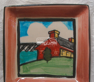 Eltham District Historical Society Inc
Decorative object - Photograph, Chris Pittard, Eltham District Historical Society Plate, c.2018
Decorative plate commissioned by Eltham District Historical Society for use as gifts for guest speakers, etc. The decoration is a representation of the EDHS logo which features the Eltham Railway Trestle Bridge and Shillinglaw CottageSquare clay plate, glazed and fired, 14.5 x 14.5 x 2cmOn face decorated with the EDHS logo in colour. On revesre "Eltham District Historical Society" and "C. Pittard"chris pittard, decorative plate, shillinglaw cottage, eltham railway trestle bridge, artwork -
 Eltham District Historical Society Inc
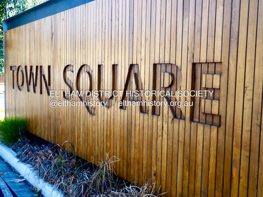
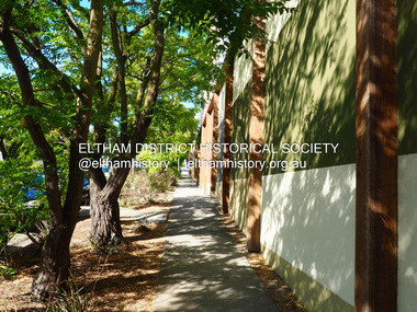
Photograph - Digital Photograph, Jim Connor, Eltham Town Square, Commercial Place, Eltham, 18 April 2018
Eltham Town Square is centred along Commercial Place running between Arthur Street and Pryor Street. Its origins stretch back to the first design proposals developed in 1979 by then Shire Planner Rodney Roscholler who later went on to become Eltham Shire Council CEO, and Cr. Robert Allenjim connor collection, commercial place, eltham shopping centre, eltham town square, the common, third chapter, jock & eddie, alter it -
 Eltham District Historical Society Inc
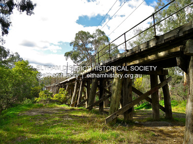
Photograph - Digital Photograph, Jim Connor, Eltham Railway Trestle Bridge, Panther Place, Eltham, 18 April 2018
jim connor collection, eltham railway trestle bridge, eltham trestle bridge -
 Eltham District Historical Society Inc
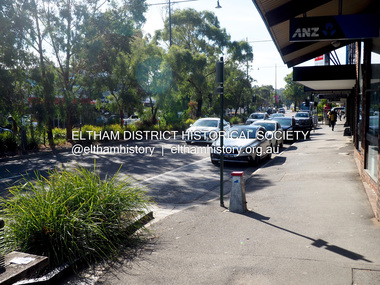
Photograph - Digital Photograph, Jim Connor, Main Road, Eltham from Arthur Street looking north, 18 April 2018
jim connor collection, anz (eltham), eltham shopping centre, main road -
 Eltham District Historical Society Inc
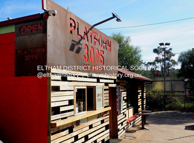
Photograph - Digital Photograph, Jim Connor, Platform 3095, 965 Main Road, Eltham, 18 April 2018
jim connor collection, eltham, main road, platform 3095, restaurants -
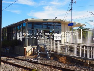 Eltham District Historical Society Inc
Photograph - Digital Photograph, Jim Connor, Eltham Railway Station, 18 April 2018
jim connor collection, eltham railway station -
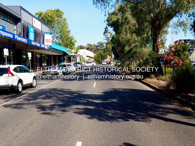 Eltham District Historical Society Inc
Photograph - Digital Photograph, Jim Connor, Main Road, Eltham looking south towards Arthur Street, 18 April 2018
jim connor collection, eltham shopping centre, main road, thompson's pharmacy -
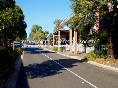 Eltham District Historical Society Inc
Photograph - Digital Photograph, Jim Connor, View looking up Pryor Street from Main Road, Eltham, 18 April 2018
jim connor collection, commercial place, eltham shopping centre, pryor street -
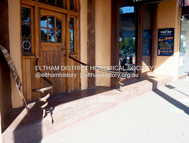 Eltham District Historical Society Inc
Photograph - Digital Photograph, Jim Connor, Todaro Hairdressing, 1030 Main Road, Eltham, 18 April 2018
Now Studio 1030jim connor collection, eltham shopping centre, 1030 main road, main road, todaro -
 Eltham District Historical Society Inc
Photograph - Digital Photograph, Jim Connor, View looking west along Luck Street from near Commercial Place,. Eltham, 18 April 2018
Former McEwans the Bunnings builing on right, now Aldijim connor collection, eltham shopping centre, luck street -
 Eltham District Historical Society Inc
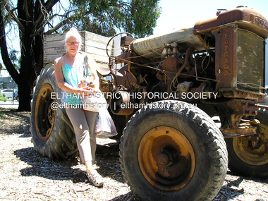
Photograph, Fay Bridge, Fay Bridge with Fordson Tractor at H.Aumann & Sons. Fruit &/or Berry Growers. 246 Tindals Rd, Warrandyte, 29 January 2018
fay bridge collection, 2018-01-29, fay bridge, fordson tractor, h. aumann & sons, warrandyte -
 Eltham District Historical Society Inc
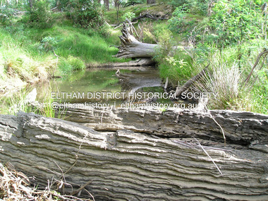
Photograph, Fay Bridge, Old timbers in the Diamond Creek at Hurstbridge, 27 February 2018
Just downstream from the bridgefay bridge collection, diamond creek (creek), hurstbridge, 2018-02-27 -
 Eltham District Historical Society Inc
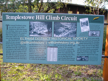
Photograph, Fay Bridge, Templestowe Hill Climb Circuit, 4 July 2018
fay bridge collection, 2018-07-04, templestowe hill climb -
 Eltham District Historical Society Inc
Photograph, Fay Bridge, Former Glynn's Dairy Farm, Glynns Road, North Warrandyte, 31 August 2018
Glynn’s farm Originally Section 7, Parish of Nillumbik marked Aborigine Reserve in 1866 Crown Allotment 8, Section 7, Parish of Nillumbik, County of Evelyn, Certificate of Title Volume 4095, Folio 818.835, approx. 93 acres purchased by Joseph Panton in 1881 for £1/acre and known as Panton’s Point. By 1924 owned by S.S. Sergeant and called Riverswood. Sergeant commissioned Edna Walling to design the garden. In September 1929 the property was sold at auction by Mortgagee’s sale. Described as well built, brick, tile roof, Attic Villa containing downstairs 7 good rooms, bath, scullery, inside lavatory, etc. Upstairs 2 bedrooms and sleep out. Outbuildings compromising of brick and weatherboard wash house, stables, workshop, feed room, cow bails, large G.I. Hay shed, etc In January 1931 Riverswood property was proclaimed a sanctuary for native game for the entire year. A private swing bridge crossed the river at Pound Bend was known as Pearson’s bridge after C.W.K. Pearson who bought Riverswood in the early 1930s. The bridge was swept away in the December 1934 floods. Riverswood was sold by C.W.K. Pearson at auction on 25 November 1936. Described as a beautiful farm home of 93 acres and over one mile of River Yarra frontage, modern brick residence, lovely garden, rich river flat pastures, model poultry farm. The fine brick home was destroyed on Black Friday (13 Jan.) 1939. It was still a ruin when the Evelyn Evans purchased Waikowhane above Riverswood in 1940. The Glynn family purchased the Riverswood property in 1941 from Robert and Emily Hannon. Their son Kenneth Patrick Glynn inherited the property and he set about clearing the land during WW2 selling wood. Prior to marriage, Kenneth was living alone on the farm in a house he had built from whatever was available. He used the bluestone foundations from the original fine brick home. He met and married Honora Elizabeth Drew in early 1945 and their daughter Anna grew up on the farm. It was compulsorily acquired by the Board of Works in 1976 who then rented the house out in the 1980s. The property was transferred to Melbourne Parks and Waterways in 1996. Waikowhane was a pretty timber house built on top of the hill on 50 acres above Riverswood by retired nurse Jessie MacBeth. (This would be at the intersection of Glynns Road and Overbank Road where the big water tank is now situated on what was once James Orford’s property.) It was also destroyed Black Friday and she rebuilt it from the plans living in a caravan on site supervising the build. It was almost complete when she died May 1939. The property was bought by Evelyn Evans (a city girl) and her estranged husband in 1940. She had two sons, one only 9 months old at the time. It was a timber house with no power or water connected. The Ewen Cameron family bought Waikowhane in 1957. They had to evacuate when the 1961 bushfires swept through. The house was saved by Matcham Skipper. It was demolished by Melbourne Water in the 1990s when they acquired it.fay bridge collection, 2018-08-31, glynn's, glynn's dairy farm, glynns road, north warrandyte, parks victoria, ruins, riverswood, kenneth patrick glynn -
 Eltham District Historical Society Inc
Photograph, Fay Bridge, Remains of apple orchard near the Diamond Creek, Wattle Glen, 11 October 2018
The newly constructed Diamond Creek Trail from Diamond Creek to Wattle Glen completed in February 2021 winds past these apple trees that possibly lined the entrance to the Greenhills property From Jean Verso, Nillumbik Historical Society, 15 April 2021 William Wandless Herbert bought the surrounding 100 acres in 1852. He was a native of Northumberland and the Scottish Borders who arrived in Melbourne in 1847. The house on the top of the mound would have been built not long after he bought the land; the farm was named "Greenhills". He married Elizabeth Wilson, daughter of John Wilson who had been in Diamond Creek since about 1846. Their first child was born in 1854 so there would be some form of dwelling from about that time. They had eight children who all survived to a good age. His will describes the house as part stone and part wood and of four rooms. Nillumbik Historical Society (NHS) believe it was one of the earliest if not the earliest house, in this part of the district. The remains of the stone house foundations are on top of the mound (photos on the VHD page) and the barn walls are on the north and to the east side of the mound. NHS is not sure how much or which part of the surrounding area was covered by the barns but they were large enough to hold dances after the race meetings that were held in the late 1880's on the adjacent creek flats. It would make sense with the lay of the land that they covered some of the ground to the north and east and used for farm storage, packing sheds for their apple and pear orchards and also for supporting the Nillumbik Gold Mine the family worked to the north up the gully. The path that comes down the gully and runs into the trail goes past the mine site which was on the west side of the gully a couple of hundred metres up from the flats. Heritage Victoria link for the site - https://vhd.heritagecouncil.vic.gov.au/places/12203fay bridge collection, 2018-10-11, diamond creek, diamond creek trail, elizabeth wilson, greenhills, wattle glen, william wandless herbert, apple trees