Showing 10982 items matching "land "
-
 Whitehorse Historical Society Inc.
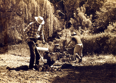
Photograph, Archibald McArthur`
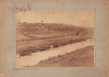
Archibold McArthur originally owned 6 acres and produced flowers which were sold at the Victoria Market, and vegetables which were sold at a roadside stall outside his property in Canterbury Road , Forest Hill.Eastside Plants established a plant nursery as p[art of the property in 1979 and later added 'Archies Cafe' in 1987. In 2007 the nursery closed its doors and in 2008 units were built on the property.Sepia photo of Archibald McArthur and one other tilling land on his property in Canterbury Forest Hillmcarthur archibald, forest hill, plant nurseries, eastside plants, archies cafe -
 Lakes Entrance Historical Society
Book, Delbridge Graham R, Freeman Anne, The Church of St Peters by the Lakes, 1976
History of St Peters by the Lakes Paynesville Victoria, acquisition of land, building plans, forward by Bishop Delbridgereligion -
Stawell Historical Society Inc
Photograph - Aerial Photograph, Norwellan / AUNDE
Textile Mill infrastructure when Norwellan North Western Woolen Mills became Norwellan Textiles then AUNDEEarly Colour Aerial Photograph showing complete land and infrastructure. Plastic frame imitating brown marble.industry -
 Bendigo Historical Society Inc.
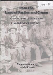
Film - FROM THE LAND OF PASTIES AND CREAM, 2010
DVD. From the Land of Pasties and Cream. A Tribute to the Cornish Miners of Bendigo and Eaglehawk. A Documentary by Jamie Roberts. -
 Bendigo Historical Society Inc.
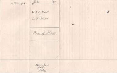
Legal record - BLOSSETT Rupert Stanley - Deed of Charge, Watson, James & Rogers, Rogers Collection, 1920
In the early 1980s the firm of Watson, James & Rogers merged with the partnership of Every & Every and became the iconic “Rogers & Every” as known today. The firm is still located on Bull Street. https://rogersevery.com.au/about/Deed of Charge concerning the purchase of land in the Parish of Mandurang, County of Bendigo. Dated 13 November 1920.Signatureswatson james & rogers, bendigo, legal documents -
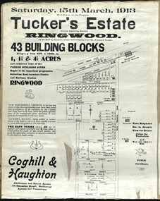 Ringwood and District Historical Society
Card - Land Subdivision Clipping, Tucker's Estate, Ringwood, Vic. - 1913
Partially trimmed copy of a land subdivision auction advertisement on cardboard backing, with digitised copy of original flyer.Subdivision includes Thanet Street, Albert Street, Arlington Street, Barkly Street, Maidstone Street, Kirk Street, Vine Street, Surrey Street, Yarmouth Street and West Prussia Road (later Wantirna Road) Ringwood, Vic. Property names include Wandsworth, Ingleside, Lyndhurst and Karsruhe. Auctioneer and Estate Agents - Coghill & Haughton, 79 Swanston Street, Melbourne Auburn and Canterbury. Licensed Surveyor - W.P. Steane, M.C.E., 317 Collins Street, Melbourne. -
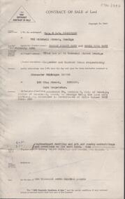
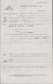
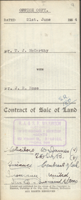 Bendigo Historical Society Inc.
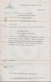
Document - H.A. & S.R. WILKINSON COLLECTION: CONTRACT OF SALE
Contract of sale of land dated 21st June, 1954 between Mr. T.J. McCarthy (seller) and Mr. J.R. Rose (buyer) for land part of Crown allotment 13 section 97C being the land delineated and coloured red and blue on the map in the margin of certificate of title volume 6325 folio 837 and situate No.450 Hargreaves Street, Bendigo. Together with 7-roomed brick dwelling and all sundry. Price 2.500 poundsorganization, business, h.a. & s.r wilkinson real estate -
 Bendigo Historical Society Inc.
Document - H.A. & S.R. WILKINSON COLLECTION: CONTRACT OF SALE
Contract of sale of land dated 7th April, 1955 between Miss G.M. Lee (seller) and Mr. R.A. Rae for land being part of Crown allotment 240 section E, land described in certificate of title volume 2708 folio 415 and situate 83 Arnold Street corner Uley Street, Bendigo. Together with weatherboard dwelling and all sundry, including all furniture, curtains and blinds. Price 850 pounds.organization, business, h.a. & s.r wilkinson real estate -
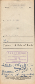
 Bendigo Historical Society Inc.
Document - H.A. & S.R. WILKINSON COLLECTION: CONDITION OF SALE
Conditions of sale by private contract dated 10th August, 1939 between Mrs L.T. McCullough (seller) and Mrs M. Rowe for the land situate Shamrock Street, Bendigo being part of Crown allotment 3, 6 and 7 section 33A land described in certificate of title volume 6198 folio 1239463. Price 190 pounds. Various receipt from Borough of Eaglehawk, Land department And water commission for rates, and other costs.organization, business, h.a. & s.r wilkinson real estate -
 Bendigo Historical Society Inc.
Document - H. A. & S. R. WILKINSON COLLECTION: CONTRACT OF SALE
Contract of sale of land dated 11th December, 1954 between Mr. E. C. Rayner (vendor) and Mr. K. O. Stokes (purchaser). Property: land situate in Letherbys Road, Eaglehawk, land described in right to occupy residence area No. 9596, together with weatherboard and brick dwelling, all sundry outbuildings, all linos, electric light fittings and shades and curtains with the exceptions of those in dining room. Price: 275 pounds.organization, business, h.a. & s.r wilkinson real estate -
 Bendigo Historical Society Inc.
Document - H. A. & S. R. WILKINSON COLLECTION: CONTRACT OF SALE
Contract of sale of land dated 12th July 1955 between Mr. C. Naismith (vendor) and Mr. J. M. Parsons (purchaser). Property: land being lot 20 on plan of subdivision No. 22101 part of Crown allotment 60 section D Parish of Mandurang, County of Bendigo and being land described in certificate of title volume 7925 folio 69 and situate Archer Street, Kangaroo Flat. Price: 140 pounds.organization, business, h.a. & s.r wilkinson real estate -
 Marysville & District Historical Society
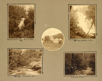
Photograph (item) - Black and white photographs, Unknown
An album page with five photographs of 5 natural attractions in an around Marysville in Victoria.An album page with five photographs of 5 natural attractions in an around Marysville in Victoria.Steavenson Falls 18/ Steavenson River 21/ "Land of mountain or flood" 20/ a Mountain Stream 22steavenson falls, steavenson river, marysville, victoria, waterfalls -
 Greensborough Historical Society
Article, Let's visit Bundoora, 1841o
This collection of notes aims 'for a deeper appreciation and understanding of the impact of our lives; culture and actions;.in Bundoora; a developing community'. Includes copies of uncited articles; photos and maps.Background information on Bundoora in the 20th century.Collection of articles, possibly notes from an oral presentation. Complete document available at GHS."Contents largely sourced from "In the beginning there was only the land", Len Kenna, 1988." - note on page 1.bundoora -
Glenelg Shire Council Cultural Collection
Photograph - Photograph - Portland Harbour, Aug-89
Port of Portland Authority ArchivesBack: 'Land slip and infill Yacht Club / Henty Beach area August 89' black biroport of portland archives -
 National Wool Museum
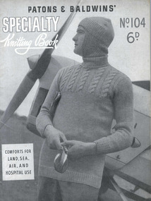
Book, Knitting, Patons and Baldwins' Specialty Knitting Book no. 104
This knitting pattern book was produced during 1939-45 by Patons and Baldwins' and contains knitting patterns for mens civilian and service garments. It also includes a number of patterns for convalescent and hospital coverings, including a splint coverKnitting Book (front cover) - Patons and Baldwins' Specialty Knitting Book no. 104, WWII. Knitting Book (back cover) - Patons and Baldwins' Specialty Knitting Book no. 104, WWII.PATONS & BALDWINS' / SPECIALTY / Knitting Book / No. 104 / 6D. / COMFORTS FOR / LAND, SEA, / AIR, AND / HOSPITAL USEknitting world war ii, patons and baldwins (australia) ltd, knitting, world war ii -
 Clunes Museum
Photograph, PURCELL, ROGER, SEBASTOPOL GARDENS, 1994 [COPY]
ORIGINAL PHOTOGRAPH OWNED BY MR. WILLIAM HARRIS OF SUTHERLAND STREET CLUNES..1 ORIGINAL SEPIA PHOTOGRAPH OF PEOPLE WORKING IN THE GARDEN ON THE OTHER SIDE OF THE CREEK. THE PHOTOGRAPH IS GLUED ON TO LIGHT BROWN CARDBOARD .2 -.4 COPIES OF POINT 1 .5 A COPY OF THE ORIGINAL (.1) PHOTOGRAPH GLUED ONTO CREAM CARDBOARDW H HARRIS LAND CIRCA 1870 -1880 WINNERS OF PICKLES AND JAMS COMPETITION IN INDIA 1886 harris family, w h harris, pickles and jams competition, sebastopol gardens -
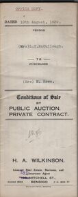
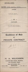 Bendigo Historical Society Inc.
Document - H.A. & S.R. WILKINSON COLLECTION: CONTRACT OF SALE
Conditions of sale by private sale dated 10th April, 1940 between W.V.O. Earl (seller) and C.M.F. Skilbeck (buyer) for land situate No.148 Booth Street, Bendigo, being the land described in right to occupy residence area No.4501. Also all the vendor's right, title and interest in that piece of land adjoining the above mentioned land described in permissive occupancy title no. W.52845, together with 5-roomed weatherboard dwelling and all sundry. Also bath, copper and troughs. Price 175 pounds. Attached Insurance cover issued by The United Insurance Company Ltd for above property. Office copy.organization, business, h.a. & s.r wilkinson real estate -
Bendigo Historical Society Inc.
Book - BOOK: LANDS OFFICE APPLICATIONS REG. SECT 35 LANDS ACT 1901
Hard cover with paper pages containing details of applications for leases of land under sect 35 Land Act 1901. Double page not numbered. No index. On left hand page columns - No, Date, Reg, Date Application, Surname, Address, Parish. On right hand page columns Allot, Sect, Area, Local Land Board, Classification, Lease, Remarks. 'Application Register' 'Section 35 Land Act 1901' on spine ‘MM’. 'Sec 138'. 2561 to 2669 now on cards' on spine. 26 September 1974 to 21 May 1976. Green cover with light brown suede spine and corners.organisation, government, official, book, lands office, applications reg. for lease, sect 35 lands act 1901 -
 Bendigo Historical Society Inc.
Document - H. A. & S. R. WILKINSON COLLECTION: CONTRACT OF SALE
Contract of sale of land dated 5th February, 1957 between Mr. D. J. & Mrs. D. N. Watt (vendor) and Mr. A.H. Pappos (purchaser) Solicitor for vendor: Hogan & Hogan, Bendigo. Solicitor for purchaser: Hogan & Hogan, Bendigo. Property: piece of land being allotment 78 section C land described in certificate of title volume 3657 folio 393, together with weatherboard dwelling and all sundry outbuildings and erections on the said land, also all linos, blinds and light fittings and shades. Price 1,700 pounds. Attached statement pursuant to section 34 of the estate agents act, 1956.organization, business, h.a. & s.r wilkinson real estate -
Warrnambool and District Historical Society Inc.
Correspondence (Rose Park), 1940s
These are four letters and a document regarding the proposal in the 1940s by the Victorian Department of Lands and Survey to acquire sections of the property, Rose Park, to establish several Soldier Settlement farms. Rose Park, near Willatook, was owned by Stan Baulch (1897-1980), the son of Samuel and Eliza Baulch. Samuel Baulch had acquired the property of Dunmore, between Macarthur and Hawkesdale, in 1893 and Stan had inherited portion of this property after his father’s death. He named his portion Rose Park. The Soldier Settlement Commission wanted to acquire 1500 acres of Rose Park but Stan Baulch argued successfully that the management of his farm could not withstand the loss of so much land and eventually 300 acres of Rose Park land was sold for closer settlement. Stan Baulch was a prominent member of the Warrnambool and District Historical Society for many years and contributed many articles and booklets on local historical matters. This correspondence is of interest as an example of the establishment of Soldier Settlement farms in Victoria post World War Two and the difficulties faced by some property owners opposed to the acquisition of their land. These items will be useful for research. .1 A six-page letter written in pencil .2 A two page letter in black typing ( contents as in .1 above) .3 A one page letter, typed, with a handwritten signature .4 A sheet of paper containing a statement re purchase of land with some inserted handwritten material .5 A two page letter with handwritten material baulch family, western district, victoria, history of warrnambool -
![Map, Late the Property of Robert Lawson Esq. [Landsberg Estate Blackwood]](/media/collectors/5e461d8021ea67224c82f2a1/items/67763722eb6d2cbd24dff14f/item-media/677637b7eb6d2cbd24dff29d/item-fit-380x285.jpg) Bacchus Marsh & District Historical Society
Bacchus Marsh & District Historical SocietyMap, Late the Property of Robert Lawson Esq. [Landsberg Estate Blackwood]
The date this map was created has not been identified. It was possibly created at the time the Landsberg Estate near Blackwood was subdivided and sold into smaller lots in December 1886. This land once belonged to Robert Lawson who died in 1869. Lawson was a well known school teacher who founded Scotch College in Melbourne before setting up a school near Blackwood. This map is similar to another map in the BMDHS collection titled 'Landsberg Estate Blackwood' Victorian Collections record 459 and was possibly produced at the same time.Single page map showing land allotments which made up the Landsberg Estate near Blackwood. Scale 20 chains to 1 inch. The map is pasted into a bound volume containing 76 maps or plans in total. High resolution digital image stored on BMDHS computer network. At the top of the map: 'Late the Property of Robert Lawson Esq.'bacchus marsh victoria maps, landsberg estate blackwood -
 Flagstaff Hill Maritime Museum and Village
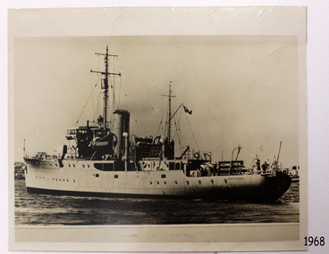
Photograph - Vessel, Steam Ship, HMAS Warrnambool J202, Between 1941-1947
The photograph shows the vessel HMAS Warrnambool J202, which was commissioned by the Royal Australian Navy for use as a minesweeper during World War II. The Bathurst Class Corvette, fitted out with a range of armaments, was launched in Sydney 1941. The ship began service in Bass Strait in 1941. At the end of the year it called into its namesake city, Warrnambool, where the crew paraded for the public marching eastwards along Timor Street. A gift of books for the ship’s personnel and a plaque bearing the City of Warrnambool’s Coat of Arms were presented to the ship. The ship was involved in evacuating a family of nine from the Dutch East Indies that was later successful in its challenge of Australia’s Immigration Restriction Act (White Australia Polity). The ship had many other appointments around Australia. On 13th September 1947 HMAS Warrnambool was leading a flotilla of minesweepers in northern Queensland’s coastal waters, clearing mines previously laid to defend Australia. The ship hit a mine, which exploded and very quickly sunk the ship. Boats from the nearby ships rescued most of the seamen although one was killed at the time. The survivors were taken by the HMAS Swan II to Darwin, and they went from there to hospitals in Brisbane and Sydney. Three of these men later died from their injuries. A number of items were recovered by Navy divers in 1948 including the ship’s bell and a plaque with Warrnambool’s Coat of Arms. In 1972-75 the wreck was sold and other items were salvaged. In 1995 a memorial plaque was erected in Warrnambool near the RSL. NOTE: The RAN built a second HMAS Warrnambool FCPB204, launched in 1981 and decommissioned in 2005. There was also a steam ship SS Warrnambool built in London 1892 and broken up in 1926. [A more detailed history can be found in our Collection Record 3477.] This photograph of HMAS Warrnambool is significant for its association with Royal Australian Navy and its vessel, HMAS Warrnambool (J202). The HMAS Warrnambool played a nationally significant role in overturning Australia’s Immigration Restriction Act 1901 (colloquially known as the White Australia policy). The ship rescued, and brought to Australia, Samuel and Annie Jacob and their family after they evacuated Dutch East India. The family was threatened with deportation and made the first successful appeal to High Court regarding that Act. The HMAS Warrnambool has - Local significance for being the namesake of the City of Warrnambool - Local significance, having docked in Warrnambool Harbour - Local significance, the crew having paraded in Timor Street, Warrnambool - State significance for its first patrol being in Bass Strait. - National significance, being present in Timor at the Japanese surrender - National significance, shown by the significance of the ship’s bell being curated as Military Heritage and Technology at the Australian War Memorial. - National significance as part of Australia’s defence force history, being one of only four Bathurst class corvettes lost while in Australian service, the only Bathurst class corvette lost after World War II, the only RAN vessel to be sunk by a mine, and associated with the last four Navy deaths of WWIIPhotograph of HMAS Warrnambool near land. Black and white photograph shows a steam and sail vessel in calm water beside land. Figures are standing on board. A flag flies on a mast. The ship's name is on the stern. The light coloured funnel has emitted a small amount of smoke.On side of ship "WARRNAMBOOL"flagstaff hill, maritime village, maritime museum, warrnambool, shipwreck coast, mort's dock & engineering co ltd, h.m.a.s. warrnambool, hmas warrnambool, hmas warrnambool i, hmas warrnambool j202, hmas swan ii, j202, world war ii, bathurst class corvette, royal australian navy, ran, sydney built ship, bass strait patrol, sea mine patrol, mine sweeper, mine clearance, navy divers, great barrier reef, cockburn reef, southern cross diving and salvage, warrnambool city council, cr j r astbury, mayor j r astbury, warrnambool patriotic fund, seal, coat of arms, dedicatory plaque, hmas warrnambool 1941, shipwreck by sea mine 1947, sinking ship, sunk ship, minesweeper -
![Escol Estate [Kew], 1940](/media/collectors/550653872162f11fb04854aa/items/59115843d0ce2b1f048f0fbb/item-media/591158fdd0ce2e1f04f1e0f5/item-fit-380x285.jpg) Kew Historical Society Inc
Kew Historical Society IncPlan - Subdivision Plan, Escol Estate [Kew], 1940, 1940
Pru Sanderson, in her groundbreaking ‘City of Kew Urban Conservation Study : Volume 2 - Development History’ (1988), summarised the periods of urban development and subdivisions of land in Kew. The periods that she identified included 1845-1880, 1880-1893, 1893-1921, 1921-1933, 1933-1943, and Post-War Development. These periods were selected as they represented periods of rapid growth or decline in urban development. An obvious starting point for Sanderson’s groupings involved population growth and the associated economic cycles. These cycles also highlighted urban expansion onto land that was predominantly rural, although in other cases it represented the decline and breakup of large estates. A number of the plans in the Kew Historical Society’s collection can also be found in other collections, such as those of the State Library of Victoria and the Boroondara Library Service. A number are however unique to the collection.The Kew Historical Society collection includes almost 100 subdivision plans pertaining to suburbs of the City of Melbourne. Most of these are of Kew, Kew East or Studley Park, although a smaller number are plans of Camberwell, Deepdene, Balwyn and Hawthorn. It is believed that the majority of the plans were gifted to the Society by persons connected with the real estate firm - J. R. Mathers and McMillan, 136 Cotham Road, Kew. The Plans in the collection are rarely in pristine form, being working plans on which the agent would write notes and record lots sold and the prices of these. The subdivision plans are historically significant examples of the growth of urban Melbourne from the beginning of the 20th Century up until the 1980s. A number of the plans are double-sided and often include a photograph on the reverse. A number of the latter are by noted photographers such as J.E. Barnes.The ‘Escol Estate’ was a subdivision, which created Bramley Court, which runs south from Sackville Street between Evans Road and Orford Avenue. The subdivision was comprised of 12 lots. At the auction of the lots in May 1940, eight of the 12 allotments were sold. The land was sold subject to a restriction of only one private residence being erected on each lot.subdivision plans - kew, sackville street – kew (vic.), bramley court – kew (vic.) -
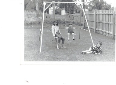 Whitehorse Historical Society Inc.
Photograph - Playground, 27 Good Governs Rd Mitcham
Black and white photographs of a family of 3 at 27 Good Governs Rd with a paddock in the background Approximately 1969On rear of Photo: This was the paddock at the back of No 27 Good Governs Street at one stage Approx 1969 (Now no 12 Irvine St Development of 27 units0 Land was sold for $3.5 million in 2009 by estate of Mr Murray Jones who was the original owner of this parcel of land He purchased the remaining land from the mortgagor of Miss Linda Roberts. John Hay is the boy with his cousins from Ringwoodgood governs rd no 27, irvine st no 12, jones murray -
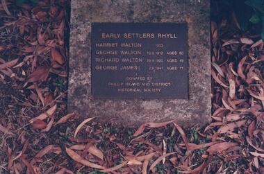 Phillip Island and District Historical Society Inc.
Photograph Album, Kodak, Phillip Island Cemetery, c 1990
The Album was compiled by Nancy McHaffie late 1990's, with the assistance of Edith Jeffery's, with her book "Garden of Memories" and extensive knowledge of Phillip Island. The Cemetery lies back from the road and is surrounded by Manna Gums, rare Peppermint Gums, Blackwoods and other native trees. In all 25 acres of land were set aside as Crown Land in the land settlement of 1868. There are 6.2 acres of wetlands near the cemetery entrance.466-40: George Walton settled at Rhyll after the Land Settlement Act was granted 8 acres in the township of Rhyll. He was the father of a large family, many descendants still live on Phillip Island. He had the honour of being the first brickmaker on the Island. He died in 1912 in his 81st year. Also Harriet Walton, Richard Walton & George James. 466-41: The Gall Family. Robert and Sarah Gall came to Phillip Island about 1869 and selected Block 10, some 20 acres. They built their home and sunk a well which still exists in Settlement Road, Cowes. Their Plaque and the Walton Plaque were donated by the Phillip Island & District Historical Society. phillip island cemetery, walton, gall, nancy mchaffie, edith jeffery -
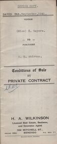 Bendigo Historical Society Inc.
Document - H.A. & S.R. WILKINSON COLLECTION: CONDITIONS OF SALE
Conditions of sale by private contract dated 5th September, 1941 between Miss H. Sayers (seller) and A.E. Stirton (buyer) for land situate corner Violet and Pitt Streets, Bendigo, at present occupied by tenants, being Crown allotment 9A section 60 B land described in Crown grant volume 955 folio 190078, together with all buildings and erections on the said land. Subject to existing weekly tenancy. Price 200 pounds.organization, business, h.a. & s.r wilkinson real estate -
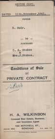 Bendigo Historical Society Inc.
Document - H.A. & S.R. WILKINSON COLLECTION: CONTRACT OF SALE
Conditions of sale by private contract dated 11th November, 1941 between H. Muir (seller) and C.E. Stokes & Mrs. J. Stokes (buyers) for land situate No. 718 High Street, Golden Square, together with 4-roomed weatherboard and rough cast dwelling and all sundry. Also all vendor's right title and interest in and to the adjoining land with a frontage to High street, and as fenced across the rear of the residence area land. Price 400 pounds.organization, business, h.a. & s.r wilkinson real estate -
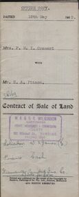 Bendigo Historical Society Inc.
Document - H.A. & S.R. WILKINSON COLLECTION: CONDITION OF SALE
Contract of sale of land dated 12th May, 1953 between Mrs. F.M.T. Crameri (seller) and Mr. H.A. Pitson (buyer) for land being part of Crown allotment 2, section 125C described in certificate of title volume 6429, folio 692 situate No. 79 Garsed Street, Bendigo, together with a right of carriage way over the land coloured blue on the certificate of title with 5-roomed weatherboard dwelling and all sundry. Price 1,825 pounds.organization, business, h.a. & s.r wilkinson real estate -
 Bendigo Historical Society Inc.
Document - H. A. & S. R. WILKINSON COLLECTION: CONTRACT OF SALE
Contract of sale of land dated 1st May, 1953 between Mr. E. J. Sheldon (vendor) and Mr. F. C. Schodde (purchaser). Property: land being part of Crown allotments 63 and 84 section A, Parish of Neering, County of Bendigo, land described in certificate of title volume 6212 folio 254 and situate in Myers Flat, together with 5 roomed weatherboard and cement sheet dwelling and all sundry outbuildings. Price: 1,075 pounds.organization, business, h.a. & s.r wilkinson real estate -
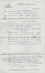
Glenelg Shire Council Cultural Collection
Document - Copy of Title and Deeds - Sinclair West, n.d
Bowerbird Museum