Showing 3733 items matching "landscape"
-
 Robin Boyd Foundation
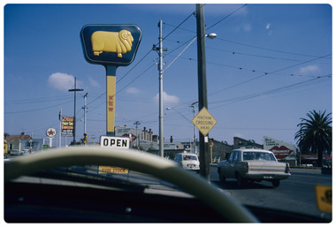
Slide, Robin Boyd, 1965
Robin Boyd has written 'Australiana' on the slide mount. Robin Boyd was always on the lookout for signage and blots on the landscape, especially when writing and illustrating his 1960 book, “The Australian Ugliness”. Colour slide in a mount. Golden Fleece sign, Kew, Melbourne, Victoria, AustraliaAUG65M/ Encircled 25 (Handwritten)/ Australiana 1 (Handwritten)/2melbourne, australiana, slide -
 University of Melbourne, Burnley Campus Archives
Work on paper (item) - Student Work, Jude Johns, Kuti Residence Garden Design, August 2015
It was likely made as an assignment for HORT90035, 'Landscape Construction and Graphics,' a subject at Burnley Horticultural College coordinated by Andrew Laidlaw. This is due to the fact that it was found amongst other student work submitted for this subject. assignment, landscaping, burnley -
Eltham District Historical Society Inc
Document - Folder, Skipper, Lena
Lena Skipper painted landscapes and seascapes; she was married to Mervyn Skipper. Contents Newspaper article: "Death of painter Lena Skipper", unnamed publication, n.d. Report of the death of Lena Skipper.Newspaper clippings, A4 photocopies, etclena skipper, mervyn skipper, james wiltshire, sonia skipper, helen skipper, matcham skipper, lena skipper nee wiltshire, eltham cemetery -
 Eltham District Historical Society Inc
Colour Print, David Taylor, View from the rear Eltham High School looking south across Ely Street, Eltham towards the Fabbro family home, c.1976
The view looks across present-day Cronus Court housing development. Aerial photos for 1976 reflect the undeveloped landscape as viewed. By 1981 the estate was well established with all houses built.david taylor collection, eltham, eltham high school, fabbro's farm, cronus court -
 Orbost & District Historical Society
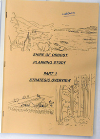
book / document, Shire of Orbost Planning Schemes March 1989, 1989
This document was produced in 1989 for Orbost Shire Council. It ccovers the area s of Orbost, Mallacoota, Cann River and Newmerella and includes urban and non-urban areas.This document is a useful reference tool.A book with a brown front cover with a plastic over-sheet and plastic binding.On the cover are b/w drawings of rural landscapes, trees and the coast. It is titled SHIRE OF ORBOST PLANNING STUDY Part 1 Strategic Overviews, March 1989.orbost-planning -
 Halls Gap & Grampians Historical Society
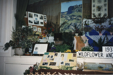
Photograph - Coloured, C 1996
This is a photo of a display at the 1996 Wildflower Show. It was a replica of the Wildflower and Nature Show in 1937. Record # 456 shows the entire display and record # 455 shows a different close-up view of the display. The photo is a close-up of a display of flowers, plants, photos and leaflets, laid out on a stage. A landscape painting and a framed wildflower painting can be seen on the wall behind the stage. A sign, partly visible on the right, reads "193(. . .) Wildflower and (. . .)".events, wildflower show -
 University of Melbourne, Burnley Campus Archives
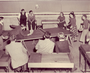
Photograph - Black and white print, Table Tennis Game, 1951
Black and white photograph.Doubles table tennis game in Landscape Design room upstairs in the Administration Building. Student seated at left rear is Graham Gregory (1952), student about to receive is Rosemary Hamley (1951). Other students watching.table tennis, landscape design room, students, graham gregory, rosemary hamley, administration building, recreation, main building, interior administration building, interior main building -
 National Wool Museum
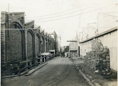
Photograph, Union Mill, 1932
The Collin's Union Mill was built in 1874 making it one of the first Woollen Mills in Geelong. The building was upgraded in 1910 and 1940. The two photos are of the same location within the mill at different years, showcasing the upgrade to the mill.The first photo is a black and white image alleyway in the Union Mill in landscape format. A pile of bricks are stacked on the right hand wall. The second photo is a sepia image of the same alleyway, showcasing the second floor upgrade to the left building.8064.1 - on rear - Union Mill 1932wool, woollen mills, geelong, wool manufacture, union mills, collins -
 National Wool Museum
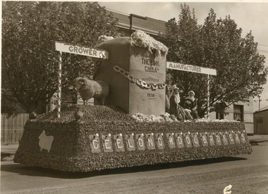
Photograph, Geelong Wool Brokers, Geelong Wool Brokers Float, 1938
Geelong Wool Brokers float for the 1938 Gala Day in Geelong. For over 20 years Geelong held a Gala Day to raise money for the Hospital. Many organisations created floats and paraded them in Geelong. In 1938 the day raised more than 10,000 pounds for the Hospital.Sepia photo of the Geelong Wool Brokers float in landscape format. The base of the float is made of flowers, on top is a taxidermy sheep with a large wool bale filled with wool. Three woman are are sat on the bottom third of the float spinning wool.On Float - Grower Manufacturer Geelong Wool Brokers The Link G.W.B.A Super Fleece 1938wool, woollen mills, wool manufacture, federal woollen mills, geelong, gala day -
 Tramways/East Melbourne RSL Sub Branch - RSL Victoria Listing id: 27511
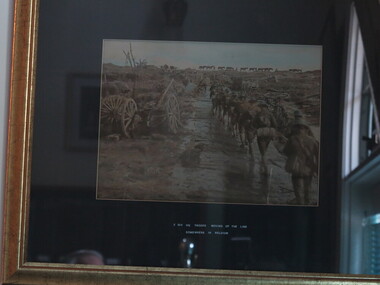
Photograph - Photo, Moving Up The Lines
A Black & White photo mounted on dark card in a light wood frame. Image shows WW1 soldiers walking along a muddy track wearing full kit. Packhorses can be seen in the background, and landscape is littered with debris of war. 2nd Div. HQ Troop Moving Up The Line Somewhere in Belguim inscribed in white ink on mat boardbelgium, cart, second division headquarter troops, horses, ww1, australian soldiers -
University of Melbourne, Burnley Campus Archives
Work on paper (item) - Student Work, Sandra Brizga, Andembach - Riverside Garden Planting Plan, 8 November 2018
Made as an assignment for HORT90035, a subject at Burnley Horticultural College coordinated by Andrew Laidlaw. assignment, burnley horticultural college, hort90035 -
University of Melbourne, Burnley Campus Archives
Booklet, Kenneth J. Polakowski, Marybyrnong Valley Metropolitan Park Master Development Plan, 1977
parks, melbourne and metropolitan board of works, kenneth j polakowski, centre for environmental studies, university of melbourne -
Broadmeadows Historical Society & Museum
Administrative record - Military Details, Elayne Whatman, c1995
Australian military, army service recordsList of Australian returned servicemen and those KIA in alphaetical order of who provided the information. Names are associated with the memorial located on Pearcedale Parade Broadmeadows.A Grey A4 landscape Super Dandy Binder containing 289 loose leaf pages. The pages contain handwritten alphabetical (by name of contact person) entries of veterans, both returned and killed, which are placed on the Broadmeadows Remembrance Memorial.list, servicemen, survived, kia, broadmeadows remembrance memorial -
 University of Melbourne, Burnley Campus Archives
Negative - Colour prints and negatives, AGFA, Burnley Landscapes and Dookie From Mt Major, 1990
26 views of the drive and garden near Plant Research Laboratory, Hilda Kirkhope Rockery and Luffmann Ponds. Many very similar. Labelled "Burnley landscapes Nov 1990." "Views of Dookie from Mt. Major." Some scanned.garden views, plant research laboratory, luffmann ponds, dookie, mt. major, hilda kirkhope rockery, lily ponds -
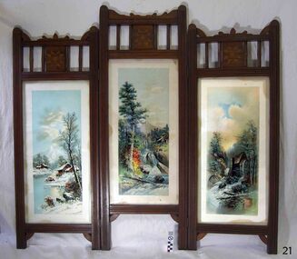 Flagstaff Hill Maritime Museum and Village
Furniture - Screen, Thomas Hope, 1905-1913
The fire screen was part of the original furnishings of the Lighthouse Keeper's Quarters in Merri Street, Warrnambool. It was made by Lighthouse Keeper, Thomas Hope. Thomas served two terms as an assistant lighthouse keeper in Warrnambool. His first term was from 1905 to 1907. He later returned from 1910 to 1913, when he was appointed as Keeper five months after the untimely death of his predecessor Peter Quinn. Woodworking was one of Thomas Hope’s hobbies, and the three-panel fire screen he made as a lighthouse keeper is now in the Flagstaff collection and is displayed in the Lighthouse Keeper’s Cottage. Thomas Hope 1857 - 1928 Thomas James Hope was born in Camden, Surrey, England in 1857. His father, also called Thomas, was reputed to be a member of the Royal Family, and Thomas Hope Junior his illegitimate son. Thomas was subsequently brought up on the estate of the Earl of Hopetoun in Somerset and it was thought that Thomas was the Earl’s grandson. Against the wishes of those in charge of Thomas, he joined the navy at an early age, seeing much of the world until he settled in New Zealand at the age of twenty-four. After some years in New Zealand, he came to Australia to live. One of the jobs Thomas Hope had prior to becoming an assistant lighthouse keeper in 1896 was as a cook in the Lunatic Asylum at Sunbury, Victoria. He served as an assistant keeper at Shortlands Bluff, Gabo Island, Split Point and Warrnambool, retiring in 1918. He bought a house in Nicholson St, Warrnambool and died in March 1928. He is buried in the Warrnambool cemetery. Thomas Hope is recorded in family history as being of short stature and, not surprisingly given his alleged aristocratic connections, possessed a beautiful speaking voice. He and his wife Elizabeth nee Waters, whom he married in New Zealand, had six children (Thomas, killed in World War One), Ellen (Nell), Nora (who was married at the Warrnambool lighthouse keepers cottage), William (who died in Warrnambool), Marion and Alan. Joseph Hoover (Dec 29, 1830, to Aug 7, 1913) Joseph Hoover, the printer of the pictures on the screen, was born in Baltimore, of Swiss-German heritage. He was trained as an architectural woodturner. In 1856 Hoover moved to Philadelphia and began producing elaborate wooden frames in his wood-turning and framing business. By 1865 Hoover had started to produce popular prints for publishers and artists, which included noted Philadelphia artist James F. Queen. In the 1880s Hoover set up a complete plant specialising in chromatography, the process of producing colour prints from lithographic plates. The coloured prints he produced were affordable to business and private customers. In 1893 his son Henry L., a trained lithographer, joined the company as overseer and it was called J. Hoover & Son. It became one of the largest in America by the turn of the century. Hoover won a medal for Excellence for his Chromolithographs of James Queen’s works. In 1904 Joseph’s other son, Joseph W, joined the business as a partner and the company was called Jos. Hoover & Sons. Hoover died of a heart attack in 1913. He was survived by his wife and six children: two sons who were also his business partners, and four daughters. The firm continued in production until around 1985. Hoover’s prints included scenes, still life and landscapes of America and other locations. They were sold in America and overseas to countries including Canada, Germany, Mexico and England. The three-panelled screen in the Lighthouse Keeper’s Cottage was made by the Assistant Lighthouse Keeper, Thomas Hope during one of his two terms at the Lighthouse Keepers' Quarters. It is the only object in the collection known to be connected to Hope. The Lighthouse Keeper's Cottage is part of the Lady Bay Lighthouse Complex, which is listed on the Victorian Heritage Register for being of historical, scientific (technological) and architectural significance to the State of Victoria.Fire screen comprising three black wood framed panels hinged together. Each panel contains a glass-encased print depicting a rural landscape. Ornate stencil cut wood edging and quilt-inspired parquetry sits above each panel. The central panel is taller than those either side. Screen is lined in black-painted cardboard.Printed at the base of each of the three prints “COPYRIGHT 1896 BY J. HOOVER & SON, PHILAD’’A.”flagstaff hill, warrnambool, shipwrecked coast, flagstaff hill maritime museum, firescreen, thomas hope junior, ellen (nell) hope, nora hope, william hope, marion hope, alan hope, jos. hoover & sons of philadelphia, lighthouse keeper, assistant lighthouse keeper, carved screen, merri street, lighthouse keeper's cottage, lighthouse residence, lighthouse, wood carving, lighthouse complex, lady bay lighthouse, fire screen -
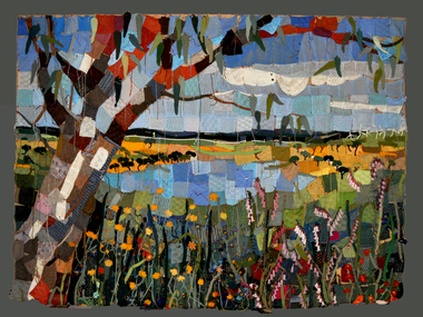 National Wool Museum
Textile - Community Textile Tapestry, Lisa Kendal et al, WARM, 2016
WARM was a community textile art project that saw over 250 knitters come together to create a beautiful collage tapestry. Made entirely from wool, the artwork contains more than 1000 individual hand knitted sections. The project takes aim at global warming, it highlights both the causes and solutions for us to create a sustainable and safe climate for future generations. Lisa Kendal, the co-creator of the project, said “One of the problems in the world is that we have forgotten how to warm ourselves with wool. We have become too dependent on fossil fuels (for heating)”. This is the key idea surrounding the project. WARM began as two large scale images created by Lars Stenberg. The first image is a landscape scarred by coal mining. The second image is the same landscape only many decades later. Regeneration and regrowth have taken over the landscape and hidden the past coal mine completely. In its place is a beautiful landscape including trees, native flowers, a lake, lots of greenery and wind turbines. From March to the end of August in 2016, knitters worked hard to create the over one thousand pieces that came together to form the final tapestry. The pieces were all designed by Fibre Artist Georgie Nicolson of Tikki Knitting Designs, who converted the second image of the healed landscape into patterns for the 250 plus knitters to follow. These patterns included unusual designs such as gum leaves, trees, native flowers and even the wind turbines. During several days of installation, the knitted pieces were stitched together by Lars Stenberg over a picture of the first image of the operational coal mine. They worked to create the second image of the renewed landscape; like an enormous collage. The WARM project was donated to the National Wool Museum in 2021. It was a much-loved hanging within the Ballarat Hospital for many years before coming to the museum. More information about the project can be found on the following website. http://www.seam.org.au/warm The tapestry is made from 1000+ hand knitted sections stitched together to make an image. In the foreground of this image is a large gum tree that stretches from the bottom left to the top right corner. The trunk of this tree follows the left edge of the tapestry, with foliage from the gum tree spanning its top border. The bottom third of the tapestry is predominantly green grass with yellow, pink and red flowers providing sporadic colour. The middle third encompasses a lake, with orange colours surrounding the banks of the water as opposed to the green grasses of the bottom third. To the right of the lake are wind turbines. The top third of the tapestry is blue sky with white clouds. It also contains the previously described gum tree leaves. Each piece of the tapestry is 100% wool and was hand knitted and stitched together. The Tapestry is accompanied by an oil painting on canvas. It is a painting that matches the tapestry and served as a template for the final tapestry. Finally, the tapestry is accompanied by another pointing on wood board. This final panting is of a coal mine. This is the setting before regeneration and regrowth have reclaimed this site, which is the theme captured in the final tapestry. In the foreground of the coal mine painting is the same gum tree described in the tapestry; however, it is grey and sickle with only 4 leaves visible at the top border, compared to the numerous leaves in the tapestry. Also in the foreground is a broken barb wire fence adding to the unwelcoming nature of the site. The colour scheme of this image is of dark greys and browns. A coal fired power plant can be seen in the final third of the image with four chimneys emitting plumes of smoke into the sky. In front of this power plant is the spiral shape of a coal mine, burrowing deep into the earth’s crust. Inside of the coal mine 3 yellow trucks are seen mining and transporting coal to the top of the mine.warm, community textile tapestry, knitting, community artwork, global warming -
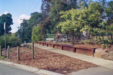
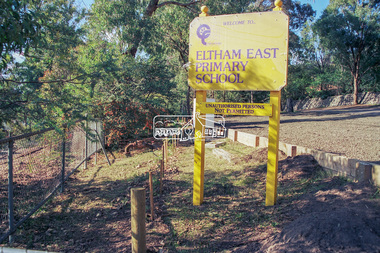
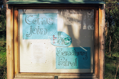
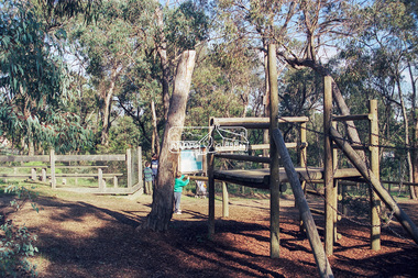
 Eltham District Historical Society Inc
Photograph - Colour Print, Peter Pidgeon, Eltham East Primary School, Grove Street, Eltham, September 1999
These photos were taken to support an application regarding 'greening' in school landscapes. The school went on to win a voucher for education supplies from 'Windmill'. Eltham East Primary School was opened in August 1963.eltham east primary school, grove street -
 Eltham District Historical Society Inc
Photograph - Colour Print, Peter Pidgeon, Eltham East Primary School, Grove Street, Eltham, September 1999
These photos were taken to support an application regarding 'greening' in school landscapes. The school went on to win a voucher for education supplies from 'Windmill'. Eltham East Primary School was opened in August 1963.eltham east primary school, luck street, wildlife sanctuary -
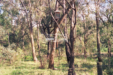
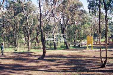
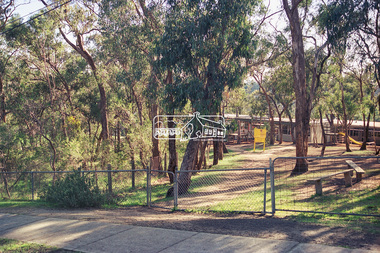
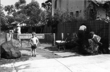 Darebin Parklands Association
Entrance to Rockbeare Park 15th February 1976, Rockbeare Park Conservation Group, 1976
Ellis Stones, well known landscape designer, designed and supervised the entrance to the Parklands from Rockbeare Grove. He designed a winding path but Council insisted on two straight paths for vehicle access.B&W photograph. Annotated with:[RPCG working bee]. Shows children Phil and Gill Course. This item and all other Darebin Parklands Association archival material is now held by State Library Victoria (Accession No: YMS 13746). Please contact State Library Victoria if access is required. -
 Marysville & District Historical Society
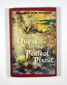
Book (item) - Hardcover book, Captain W.E. Jones, The Quest for the Perfect Planet-A story of Space Exploration, 1961
A novel by Captain W.E. Jones that was held in the Marysville State School library.A book from the Marysville State School library.Stamp of the STATE SCHOOL No. 1273/ UPPER/ 3/ FICTION/ MARYSVILLE In both front and back inside cover's labels have been removed leaving behind glue residue. Stamp of the Marysville & District Historical Society Inc/ P.O. Box 22/ Marysville 3779captain w.e. jones, planet, earth, space exploration, fiction -
 Federation University Historical Collection
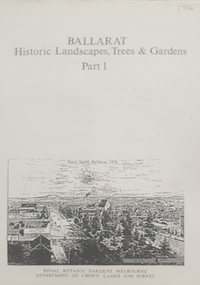
Book, Peter Lumley et al, Ballarat: Historic Landscapes, Trees & Gardens, 1983, 1983
Lisa Green and Lisa Morcom of Ballarat College of Advanced Educatiion contributed to this report.275 page landscape study of Ballarat including Trees in the Victorian Landscape; Plant sources early Ballarat nurseries, Botanical Gardens, Lake Wendouree, Fairy Gardens, Victoria Park, Ballaarat Old Cemetery, Eastern Oval, City Oval, Ballarat East Town Hall Gardens, Eureka Stockade, Observatory, Yarrowee, Black Hill, Sovereign Hill, Cheek Channels, Canadian Creek, Poverty Point Reserve, Goldmining Relics, Woah Hawp, Buninyong, street plantings, Russell, Victoria, Bridge Mall, Sturt Street Gardens, Avenue of Honour, Webster, Elms, ballarat, trees, nursery, r.u. nicholls, francis moss, ballarat botanical gardens, victoria park, lake wendouree, ballaarat old cemetery, eastern oval, ballarat east town hall gardens, ballarat school of mines botanical gardens, eureka stckade recreation reserve, ballarat observatory, yarrowee creek, black hill reserve, sovereign hill, ballarat avenue of honour, victoria street plantings, bridge mall plantings, george longley -
 Kiewa Valley Historical Society
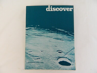
Book - Religious Education, Discover by June Wright, Peter Harvey, Robert Evans x2, 1970
Students attended Sunday School classes at the Kergunyah Presbyterian Church. Sunday school was held in a little 16 foot square wooden building which came from Rocky Valley after it was no longer needed there. Ewen Wallace's father initiated and organised the move. C2011 the building was knocked down because of white ants. The Presbyterian Church will be 125 years old in 2015.Historical: Religious Education: This book was used by students who attended the Sunday School classes at Kergunyah Presbyterian Church. Religion: Presbyterian Church at Kergunyah, in the Kiewa Valley, celebrates its 125th anniversary in 2015 after being handed over to the uniting Church in the 1970s.Green cardboard covered book. Dark green top half with white, lower case block letters at the top. Lower half is lighter green depicting moon landscape. Similarly the back cover. 50 pages held by 3 staplesreligion, religious education, presbyterian, methodist, churches of christ, congregational church, anglican, christian, kergunyah, sunday school, ewen wallace -
 Bendigo Military Museum
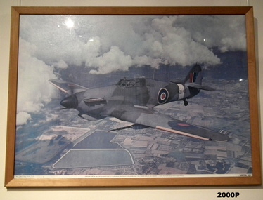
Photograph - PHOTOGRAPH, FRAMED, HURRICANE K2193
Framed Coloured print/photo of Hawker Hurricane A/c KZ 193, Prototype MK5 40 mm cannon. Aircraft in flight with cloud and landscape depicted below. Tropicalised air intake Frame - Light brown timber, glass front. photography-photographs, frame accessories; trades - carpentry; military history - airforce, airforce, photo, aircraft