Showing 110300 items matching "roads"
-
 Glenelg Shire Council Cultural Collection
Award - Cloth Badges - Henty Division Brownies 1990, c. 1990
16 Sept 1990 activity day at home of Joy Rundell, Flacks Road Heywood Victoria.Identifying numbers 8835 a,b 2 cloth badges, Henty Division Brownies, 16 Sept 1990 activity day at home of Joy Rundell, Flacks Road Heywood. Light brown woven fabric, black print and symbols depicting activities. -
 Surrey Hills Historical Society Collection
Document - Account, C. L. Swift order docket re Mrs Matthews. 21/8/1957
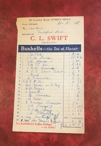
Clive Leslie Swift (RAAF 430415) was born in Elsternwick in 1924 and served in the RAAF in Borneo during WW2. He was mentioned in dispatches. He married Enid (Ina) Mary Smith in 1947. Together they ran the grocery store at 10 Croydon Road from 1949 until some time after 1954. In the 1980s they were living in Highbury Road, East Burwood and Clive was working for Unigate (later Bonlac) in a managerial position. (REF: Oral testimony, Libby Wilson, Canterbury History Group). The shop continued after the Swifts left but was later destroyed by fire. Clive Swift died in March 2014. This and other dockets were tucked into Ruth Matthews' recipe folder. Ruth and Harold Geoffrey (Geoff) Matthews lived at 42 Guildford Road, Surrey Hills. The donor recalled that her paternal grandmother (Ethel May Matthews) also occasionally shopped at the Swifts' shop as it was closer to her home (31 Guildford Road) than either than Griffith’s on Union Road or Thomas’ on Maling Road . Dockets such as these are reflective of shopping in the pre-supermarket era when women generally walked to the local shop or had proprietors or a staff member come to the house to take weekly orders. A pre-printed grocery docket for C. L. Swift (Late R.A.A.F.) on cream (discoloured) paper printed in black, red and blue filled in with 20 hand-written items, their prices and the total of the grocery order. Signed with initials as having been paid. Order was for Mrs Matthews of Guildford Road.On the rear in blue ink an addition in pounds, shillings and pence.clive leslie swift, miss enid (ina) mary smith, mrs enid (ina) mary swift, croydon road, guildford road, grocery store, docket, accounts, bushells tea, mrs ruth matthews, harold geoffrey matthews, 'geoff' matthews -
 Surrey Hills Historical Society Collection
Photograph - Digital photograph, George L Coop, 690 Whitehorse Road, Mont Albert 1958, 1958
The donor George Lister Coop was about 21 years of age when he took this photo in 1958 from the Coop family home at 688 Whitehorse Road. Ralph Walton, a bricklayer, and his wife Maria lived at 690 Whitehorse Road from c1931 (when it was numbered 447) until their deaths. Maria died in 1944 aged 77 years and Ralph died in 1959 aged 85 years. Whitehorse Road was renumbered in 1936.A view from the adjacent front garden of 690 Whitehorse Road, Mont Albert which includes some garden details of 688. A wire fence divides the 2 properties. No 690 is a red brick Californian bungalow style home with a tiled roof and a veranda offset to the eastern side.george l coop, whitehorse road, mont albert, ralph walton, maria walton, californian bungalow -
 City of Moorabbin Historical Society (Operating the Box Cottage Museum)
Photograph, Black & White Horse drawn scoops earthwork in Moorabbin Shire c1900, c1900
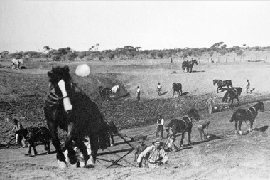
The, horse drawn metal scoop ,guided by a man, was used to clear earth for road making. Well before the introduction of motorised, mechanical graders and trucks the painstaking, labour-intensive work was undertaken by large teams of sturdy men using strong horses such as the draught horse. Roads were needed by the market gardeners to transport their produce to market. Later as the heavy wagon loads continually caused ruts and general degradation of the roadways a Plateway system was installed so that the wagon wheels could roll along the rails thus protecting the roadways. August 31st 2021 Ron Nash, from WA, informs us "The men and horses pulling earth scoops in the photo are not moving earth for road making - they are excavating an "earth tank", or dam, as described in common nomenclature today. This skill was known as "tank sinking", and tank sinkers were active in many rural and remote areas in the 1800's and early 1900's, establishing sizeable dams for important water reserves for community and farm and railway use. With the advent of mechanised equipment such as bulldozers, the trade of tank sinking was still carried out, but on a faster basis. I am a former tank sinker and earth moving contractor, now long retired." Early settlers in Moorabbin Shire had to build the roads, plateways, drains, as the settlement of the land, in Dendy's Special Survey 1841 Brighton, spread and market gardeners need to transport their produce to market. Their most valuable possession was the draught horse that was used for ploughing, drawing carts and these scoops.Black & White photograph showing many horses pulling metal scoops guided by men to move earth for road making in Moorabbin Shire c 1900Back Handwritten Informationplateway, roadworks moorabbin shire, draught horses, metal scoops, paviers, box alonzo, smith j l; chaff cutter, horse drawn carts, toll gates brighton, motor cars 1900, steam engines, early settlers, bentleigh, mckinnon, parish of moorabbin, city of moorabbin, county of bourke, moorabbin roads board, shire of moorabbin, henry dendy's special survey 1841, were j.b.; bent thomas, o'shannassy john, king richard, charman stephen, highett william, ormond francis, maynard dennis, market gardeners, vineyards, orchards -
 Melbourne Tram Museum
Photograph - Black & White Photograph/s, Bob Prentice, c1915
Black and white photograph of PMTT No. 57 in Burke Road Camberwell c1915. Tram showing route No. 12. Possibly at Mayston St. In the view is the State Savings Bank, a Real Estate agent, a snooker hall and a button shop. Photograph features on page 59 of Ian Brady's book on the PMTT, "Melbourne's Foremost Municipal Tramway". Photograph from the Bob Prentice Collection - from the Rose Series post-card P3639. Two copies held.Has caption on the photo "Burke Road, Camberwell c1920's" and in pencil on the rear 'RSCP 325", C1916 and in red ink "H57"trams, tramways, pmtt, burke road, camberwell, tram 59 -
 Surrey Hills Historical Society Collection
Photograph, Empire Day in Surrey Hills circa 1912
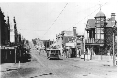
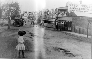
Empire Day celebrations were held from 1908-1912. Prior to the opening of the railway in 1893 the only public transport to Surrey Hills was the Melbourne-Lilydale horse coach which travelled to Surrey Hills down Victoria Street and Mont Albert Road. The fare to Union Road was 9 pence. Photo 16-4a was the number given to the original print provided by the State Savings Bank. Ken Hall made a negative from it, and the reprint of this was given the number 1459. This number was chosen as the catalogue number to avoid confusion with SHP4a. Photo provided by Surrey Hills branch of State Savings Bank of Victoria in 1978 for launch of Surrey Hills Neighbourhood Centre and was one of the first photos in the collection. The inscriptions on the reverse may indicate it was used in the Surrey Hills Neighbourhood News.Black and white photo of Union Road looking south towards Canterbury Road. The street is decorated with lanterns and the Union Jack and other flags for Empire Day celebrations. There is a young girl in the foreground looking towards the railway crossing where there is a horse drawn cab and a horse drawn cart. Business signage includes that for a butcher, Sneddon's Real Estate and Otto Preuss, Economic Undertaker.On rear: "113% "; "Enlarge to 172 mm" and 2 arrows, all in blue biro.union road, empire day celebrations, horse drawn vehicles, undertaker, sneddon real estate, businesses, union road shops, otto preuss -
Whitehorse Historical Society Inc.
Map, before 1890
Early map showing location and areas of plots and their owners' names between Heatherdale Road in the east and Springvale Road in the west, Burwood Road to the south to north of Canterbury Road. Later additions to 1969Early map showing location and areas of plots and their owners' names between Heatherdale Road in the east and Springvale Road in the west, Burwood Road to the south to north of Canterbury Road. Later additions to 1969Early map showing location and areas of plots and their owners' names between Heatherdale Road in the east and Springvale Road in the west, Burwood Road to the south to north of Canterbury Road. Later additions to 1969mitcham, vermont, nunawading -
Whitehorse Historical Society Inc.
Map, Municipality of Nunawading, c1950
Plan No 234, compiled and photo-lithographed at the Melbourne and Metropolitan Board of Works under the direction of G.R. McGowan, Chief Surveyor.Plan No 234, compiled and photo-lithographed at the Melbourne and Metropolitan Board of Works under the direction of G.R. McGowan, Chief Surveyor. Covers the area each Side of Canterbury Road from Orchard Grove to Vernon Street. Includes detail of creeks.Plan No 234, compiled and photo-lithographed at the Melbourne and Metropolitan Board of Works under the direction of G.R. McGowan, Chief Surveyor. blackburn south, gardiners creek, blackburn, blackburn creeklands -
 Melbourne Tram Museum
Negative, Wal Larsen, 6/05/1940 12:00:00 AM
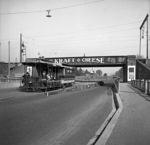
Photograph of a cable tram set in Queens Parade Clifton Hill, passing under the railway bridge at Clifton Hill 6-5-1940. The tram has the destination of Northcote. The bridge has an advert for Kraft Cheese. Road lowered in preparation of closure. Photo Wal Larsen. Trailer No. 506. In the background is the cabin for turning trams at the Clifton Hill depot or car sheds.Negative of a photograph black and white.on rear of negative in album "Getting ready for the double-decker buses at Clifton Hill. Road has been lowered on either side when cable goes rest of road will be lowered. Trailer 506 is shown. 1145am 6th May 1940 and camera settings. Photo by W. H. Larsen."trams, tramways, cable trams, queens parade, closure, clifton hill, bridges, railways, tram 506 -
 Melbourne Tram Museum
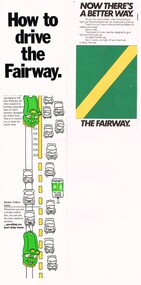
Pamphlet - How to drive the Fairway, VicRoads, "Now there's a better way"
Provides the basis for segregating road traffic from tram lines at intersections and along roadways and road markings applied.Yields information about the introduction of Fairways into Melbourne tramway streets during 1983, the first legal segregation of trams from road traffic.Set of two pamphlets regarding Tram Fairways. .1 - Three-section vertical fold-out pamphlet titled "How to drive the Fairway" printed on gloss paper showing the fairway system and how its works with the various signs in a cartoon manner. Notes the Fairway system was set up in 1983 and the basis of it. Has the VicRoads logos, name, and "Victoria Growing together? logos. .2 - Three-section, horizontal format pamphlet on plain paper, titled "Now there's a better way", giving details of the system, showing drawings and how they work at intersections. Issued by the Road Traffic Authority, has the RTA logo. .3 - Newspaper cutting, titled "The old way, the Fairway" giving advanced notice of the introduction of the Fairway system and the roads impacted. Has an AEC election advertisement on the rear for the March 1983 Federal Election.fairways, cartoons, rta, vicroads, traffic control, trams, tramways -
 Lakes Entrance Historical Society
Photograph - Apex Park Lakes Entrance Victoria, M Holding, 1985 c
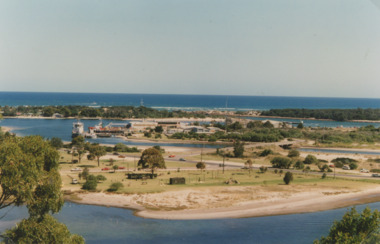
The town section of North Arm previously known as The Backwater Road Colour photograph taken from Kalimna Heights showing outer barrier and entrance channel. Road and new bridge to Bullock Island Apex Park beside North Arm in foreground has old playground equipment with timber fort and hillock with underground tunnel Lakes Entrance Victoria topography, waterways, parks, bullock island -
 Glen Eira Historical Society
Album - Album page, Nithsdale now Five Way Hill, Kambrook Road, Circa 1972
This photograph is part of the Caulfield Historical Album 1972. This album was created in approximately 1972 as part of a project by the Caulfield Historical Society to assist in identifying buildings worthy of preservation. The album is related to a Survey the Caulfield Historical Society developed in collaboration with the National Trust of Australia (Victoria) and Caulfield City Council to identify historic buildings within the City of Caulfield that warranted the protection of a National Trust Classification. Principal photographer thought to be Trevor Hart, member of Caulfield Historical Society. Most photographs were taken between 1966-1972 with a small number of photographs being older and from unknown sources. All photographs are black and white except where stated, with 386 photographs over 198 pages. Glen Eira Heritage Management Plan (1996) by Andrew Ward and Associates - Vol 3 "Nithsdale", built for J.S. Crouchin 1858 and extended in 1885 with a tower and associated rooms, survives as testimony to the nineteenth century occupation of the vicinity of the Kambrook/Glen Eira Road intersection. Caulfield's Building Heritage by Dr Geulah Solomon, Vol 1 p49 records it as a small Victorian mansion home on bluestone foundations of Italianate style with a tower. Built for J S Chambers circa 1860, it was built in stages and then the land subdivided in the 1920s. Other owners include Adolph F Brockhoff (of Brockhoff Biscuits company). Names used besides Nithsdale have been Bundoora and Five Way Hill. Page 102 of Photograph Album with four photographs (three landscape and one portrait) of Nithsdale, now known as Five Way Hill. Three views of the tower and one of the house.Handwritten: "Nithsdale" now "Five Way Hill" Kambrook road [top right] / CNR KAMBROOK AND GLENEIRA ROADS [under bottom right photo] / 102 [bottom right]trevor hart, north caulfield, victorian, mid victorian, late victorian, tower, j.s. crouchin, 1850's, 1880's, italianate, rendered, five way hill, nithsdale, slate roof, plaster arches, ornamental columns, triangular pediment, ornamental parapet, cast iron balconies, kambrook road, glen eira road, t crouch, j s crouchin, mansions, j s chambers, bluestone foundations, land subdivision, adolph f brockhoff, bundoora, house names -
 Kew Historical Society Inc
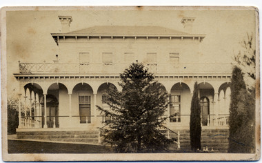
Photograph - 'Clutha', Studley Park Road, 1860-1890
Clutha was the home of John Carson, the second mayor of Kew. Leonard Terry designed the house for him in 1856. Terry was the architect of the Melbourne Club (1858), the former London Chartered Bank (1861), Lothian Terrace in Carlton (1865), and the ES&A Bank in Hawthorn (1873). The commission for Clutha was won three years after Terry’s arrival in Victoria.An extremely rare photograph of a major residential architectural commission of Leonard Terry. The photograph of the house has statewide significance as the home of the Victorian pioneer and businessman, John Carson. A rare, nineteenth century photograph of ‘Clutha’ in Studley Park Road, Kew. The sepia-toned photograph is of the front of the house, with its bluestone foundations and its second storey balcony. A real estate advertisement in 1875 described the house as: 'First-class family mansion, and about 8½ acres of pleasure grounds and fruit garden. The house, erected under the plans and supervision of Mr. Leonard Terry, is most substantially built of brick, stuccoed, on solid bluestone pediment, forming a noble basement story, large entrance hall, and lobby, with conservatory on the left. *** A wide verandah and balcony, erected on cast-iron columns, runs round the house, the views from which are perhaps unequalled in extent and beauty in the neighbourhood of the city, commanding the bay, shipping, Mount Macedon, and Dandenong Ranges. Th e whole forming a most complete gentleman's residence, no expense having been spared in its erection and comfortable finish.'"Clutha West Side Studley Park Road Kew / Clutha West Side"clutha, john carson, leonard terry -
 Mt Dandenong & District Historical Society Inc.
Photograph
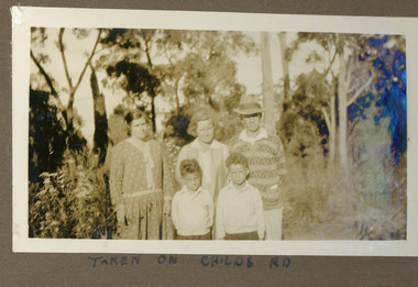
The photograph is from the album of Ivy Child. It shows Ivy's mother Ethel Child (LHS) standing on Childs Road with another couple and their two young sons. Ivy May Child (1910 – 1989) was the daughter of Arthur Edward (Ted) Child (1878 – 1964) and Ethel May Madden (1888 – 1970). Ted Child was the son of Matthew Francis Child (1839 – 1933) and Martha Jeeves (1857 – 1926). He was the grandson of one of the early pioneers Francis Child. Ivy grew up on the family property on Childs Road and took many photographs. Most of these are glued into her photo album. The album covered the years from c1927 – 1932. Ivy married Henry William Burgess (1906 – 1968) in 1944. The photographs remain in their original state in the album with individual copies made. Sepia coloured photograph showing two women and a man standing with two young boys in front of them on an unmade bush road. The man is wearing a hat.Handwritten below the photograph in album: TAKEN ON CHILDS RDivy child, ethel child, childs road -
 Lakes Entrance Historical Society
Photograph - Pat McNamara, Glenda Nixon, Wally Evans, Bruce Evans, Lakes Post Newspaper, 10/11/1995 12:00:00 AM
launch of the Sport Kite Festival at Lakes Entrance showing Pat McNamara Glenda Nixon Wally Evans and Bruce Evans at Palmers Road Office Lakes Entrance VictoriaBlack and white photograph taken at the launch of the Sport Kite Festival at Lakes Entrance showing Pat McNamara Glenda Nixon Wally Evans and Bruce Evans at Palmers Road Office Lakes Entrance Victoriasports, kites, events -
 Federation University Historical Collection
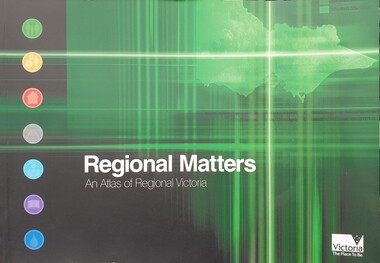
Book, Department of Infrastructure, Regional Matters: An Atlas of Regional Victoria, C2003
... roads ...Green soft covered book including chapers on population, jobs and industry, housing, road and rail transport, health services, education, and water resourcesvictoria, regional victoria, population, migration flow, jobs, industry, export, food production, housing, rail, roads, health, education, qualifications, water, irrigation -
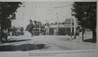 Glen Eira Historical Society
Tramways in Caulfield
Photograph of Tramway corner Balaclava Road and Hawthorn Road circa 1915caulfield, balaclava road, hawthorn road, tramways -
 Whitehorse Historical Society Inc.
Photograph, Canterbury Road, C.1967
Black and white photo of Service Road on south side of Canterbury Road.canterbury road vermont, service roads -
 Surrey Hills Historical Society Collection
Photograph, Mrs Frances Le Couteur and members of the Surrey Hills Salvation Army Corps, 1977
Frances Charlotte Le Couteur (born c1893) taught at both Chatham and Canterbury Primary Schools and at the Salvation Army in Guildford Road. She lived in Guildford Road for part of her life and taught music. She was on the staff of Chatham Primary when it opened in August 1927. She taught at Canterbury Primary for 20 years. She retired to live in Inala Village. Obituary: Frances Charlotte Le Couteur, of Inala Village died on June 17th, 1986. Loving wife of Norman (dec.), loved mother of Frank (dec.), and Boyce and grandmother of Ann, Sally and Guy. Great grandmother to Peter, James and Annabel. Date of photo is approximate.Black and white photo of Mrs Frances Le Couteur seated with a group of 10 children and a Salvation Army officer at the Salvation Army citadel in Guildford Road, Surrey Hills.salvation army, children, music, religion, mrs frances lecouteur -
 Ringwood and District Historical Society
Photograph, Canterbury Road, Ringwood taken under power lines looking east just east of Heatherdale Road. 1979
Written on back of photograph, "Jan. 79. Canterbury Road taken under power lines looking east just east of Heatherdale Road looking up the two-laned Road towards Cadbury McRobertsons before road widening". -
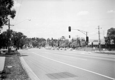 Ringwood and District Historical Society
Photograph, Canterbury Road looking east from west side of Heatherdale Road intersection up towards Cadbury. Ringwood January 1979
Written on back of photograph, "Jan. 79. Canterbury Road looking east from west side of Heatherdale Road intersection up towards Cadbury where road narrows down 3 to 1 lane. Before road widening." -
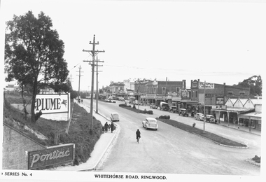 Ringwood and District Historical Society
Photograph, Maroondah Highway Central, Ringwood. Whitehorse Road looking west from Warrandyte Road. c1930's
Black and white photograph (2 copies)Inscribed on photograph: "Series No 4. Whitehorse Road, Ringwood. Image shows shops on north side of road from Warrandyte Road railway bridge to Ringwood Street. -
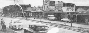 Ringwood and District Historical Society
Photograph, Maroondah Highway Central, Ringwood. Main Street shops looking west from Warrandyte Road, c1950's
Newspaper clipping of black and white photograph.Image shows shops on north side of Whitehorse Road between Warrandyte Road and Adelaide Street. -
 Glen Eira Historical Society
Album - Album page, St Stephen's Presbyterian Church, Balaclava Road, Circa 1972
This photograph is part of the Caulfield Historical Album 1972. This album was created in approximately 1972 as part of a project by the Caulfield Historical Society to assist in identifying buildings worthy of preservation. The album is related to a Survey the Caulfield Historical Society developed in collaboration with the National Trust of Australia (Victoria) and Caulfield City Council to identify historic buildings within the City of Caulfield that warranted the protection of a National Trust Classification. Principal photographer thought to be Trevor Hart, member of Caulfield Historical Society. Most photographs were taken between 1966-1972 with a small number of photographs being older and from unknown sources. All photographs are black and white except where stated, with 386 photographs over 198 pages. From: Glen Eira Heritage Management Plan (1996) by Andrew Ward and Associates In 1905, the land was vacant in Balaclava Road, north side, from Kooyong Road east to the right of way, except for one house. A block of this land was acquired by the Presbyterian community and a timber church erected there in 1910. In time, a larger church was required. After several years of fund raising led by George Kinross, a new red brick St Stephen's church was built in 1926 to the design of architects Haddon and Henderson. George Currie was the builder and the cost of construction was £5,100.From: Glen Eira Heritage Management Plan (1996) by Andrew Ward and Associates: St Stephens has architectural importance as a noteworthy example of a Gothic Transitional design in the Arts and Crafts eclectic manner (see Stylistic Typology in National Trust's Historic Church's Study}. The facade treatment successfully combines Christian symbols with Gothic forms in the Arts and Crafts mode (comparable with Haddon's Presbyterian Church, Malvern (1906) and Haddon and Henderson's Oakleigh Church (1928). It is locally important as an example of Robert Haddon's work in Caulfield, where he also lived (4 Glenferrie St q.v.).Page 26 of Photograph Album including three black and white photographs of St Stephen's Presbyterian Church, with two photographs in portrait mode across the top showing 2 different stained glass windows from the inside; and one in landscape mode in the bottom section which appears to be a photograph of a framed photograph or drawing of the church.Hand written: St Stephen's Presbyterian Church Balaclava Road [top right] / 26 [bottom right]trevor hart, caulfield north, balaclava road, george kinross, haddon and henderson, george currie, st stephen's, 1900's, 1920's, gothic transitional, christian symbols, arts and crafts, robert haddon, stylistic typology, gothic, drawings, presbyterian church, architects, lead lights, stained glass windows -
Federation University Historical Collection
Photograph - Black and White Photograph, Blue Mountains, 15/11/1851
Photograph of an illustration from teh Illustrated London News, 15 November 1851The Australian 'Diggins' and the road to themblue mountains, diggings -
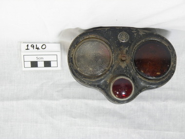 Gippsland Vehicle Collection
Vehicle Tail Light, 1940 (estimated)
Lucas Electrical manufactured light and electrical components for many vehicle manufacturers in England and many manufacturers used them as accessories or added extras.Lucas granted Richards Body Builders of Adelaide, Australia, permission to use the phrase 'King of the Road' as their trade nick name.Kidney shaped metal & glass, four lens number-plate & tail light combinationKing of the Road maker's marktail light, stop light, light tail, king of the road light, number plate light -
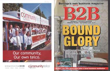 Bendigo Historical Society Inc.
Magazine - B2B BENDIGO BUSINESS MAGAZINE, September 2005
Magazine, B2B Business 2 Business Magazine Bendigo Region, September 2005. Bound Glory Traditional techniques bring treasures back to life. Price $2.20Newsprinters Pty.Ltd.Melbourne Road, Kiallabusiness, retail, advertising -
 Mt Dandenong & District Historical Society Inc.
Photograph, Sassafras-Olinda Road, c1913
This set of 8 photographs was produced by the Rose Stenograph Co. c1913 to be included in photograph albums. The show tourist scenes of Sassafras and surrounds. The photographs were donated by a family in Western Australia whose parents lived in Sassafras c1918.Small b & w photograph from a series of 8 showing scenes from Sassafras produced by the Rose Stenograph Co. c1913.On reverse - Sassafras - Olinda Roadsassafras, olinda, sassafras-olinda road -
 Mt Dandenong & District Historical Society Inc.
Photograph, The Main Road, Sassafras, c1913
This set of 8 photographs was produced by the Rose Stenograph Co. c1913 to be included in photograph albums. The show tourist scenes of Sassafras and surrounds. The photographs were donated by a family in Western Australia whose parents lived in Sassafras c1918.Small b & w photograph from a series of 8 showing scenes from Sassafras produced by the Rose Stenograph Co. c1913.On reverse - The Main Road, Sassafras.sassafras -
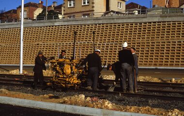 Melbourne Tram Museum
Slide, Keith Kings, 10/08/1968 12:00:00 AM
35mm Kodak white cardboard colour slide by Keith Kings of 10/8/1968 Queensway, St Kilda Junction road works, track tamping using a VR hired tamper. Note the cloth wrapped up caps on two of the workers - Italian immigrants most likely. See Keith's slide notes.Keith Kings stamp and number "32-27", with details of exposure. "VR tampers on hire in Freeway section of new track near Punt Road 10/8/68".trams, tramways, st kilda junction, trackwork, road works, queensway, ballast