Showing 2637 items matching "sheds"
-
 Port Melbourne Historical & Preservation Society
Photograph - William Johnstone KNOX leaving for WWI, 1915
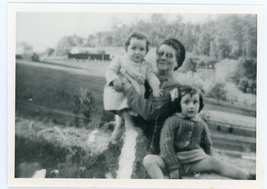
Bill did not return from the war. More information in "World War One - a history in 100 stories" by Bruce SCATES, Rebecca WHEATLEY and Laura JAMES.Three black and white photos Of William Johnstone KNOX (Bill) and family members there to see his departure with the 13th Field Artillery Brigade, World War I. .02 shows KNOX with family members and in background are Town Pier sheds .03 shows KNOX with car and in background Pier Hotel and morley's Coal Depot .04 shows KNOX and family and streetscape of Pier Hotel and rear of buildings on Bay Stbuilt environment - commercial, war - world war i, piers and wharves - town pier, william johnstone (bill) knox, pier hotel, morley's coal depot -
 Bendigo Historical Society Inc.
Document - Phillip's Water Wheel, Diamond Hill, Bendigo, 1876
'Messrs. George Phillips and Richard Williams erected a water wheel crushing machine near the site of the Old Albert shaft at Diamond Hill'. ( Bendigo Advertiser 4th June, 1890). The lack of water available for the venture from the water race caused much controversy in the following years. There was only enough water available in July 1890, to allow the company to operate three head of a ten head stamper. The site of the water wheel is still visible on the side of the water race at Diamond Hill. Mr. Geo Phillips held 1000 shares in the float of the Kangaroo Hydraulic Crushing & Gold Mining Company. He was one of the largest shareholders. (Victorian Government Gazette 72 Page 2260, 1893) Black and white photocopy. Image shows the Phillip's Water Wheel on Diamond Hill, Bendigo, date unknown but must be in 1890's. Three men and a dog standing in front of a weatherboard shed, brick chimney on side. Large water wheel on left hand side of image. Three images, 2008, showing former site of water wheel on channel, after heavy rain in district caused dry channel to run. mining, sandhurst, phillip's hydraulic waterwheel, stafford gold mine, diamond hill, george phillips, richard williams -
 Whitehorse Historical Society Inc.
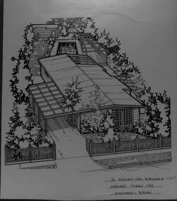
Artwork, other - Ink Line Drawing, 26 Highview Gve., Burwood E, 1994
A property illustration by Margaret Picken Commissioned by the real estate agency Fletchers Real Estate for the purpose of advertising 26 Highview Gve., Burwood in 1994 Made by using Rotring ‘Rapidigraph’ drafting pens with Rotring ink on Rapidigraph polyester drafting film, double matte. This property is listed as having sold for $160,250 in 1994 Since being sold the land has been redeveloped, with nothing remaining of the house depicted in this drawing. Trained as a cartographic draftsman within the mining industry, Margaret Picken is an artist who worked producing property illustrations for real estate agencies in eastern suburbs of Victoria from 1983-2005. Retiring from the industry as technological changes favored coloured photography over illustrations, and commissioning companies over sole contractors.This artwork is of Historical Significance as a record of local domestic architecture.A black ink line drawing on drafters film by Margaret Picken, of 26 Highview Gve., Burwood East. An angled birds eye view from the street of a weatherboard house and carport. Extending to the backyards with pool, pagoda, and shed in the background. There are two hole punch holes on near the left edge. There are some crinkles in the paper near the top centre of the work. There is a two centimetre long mark along the centre top edge.26 Highview Gve., Burwood E Margaret Picken -94 Woodards B/Burnwhitehorse historical society, schwerkolt cottage, housing, architecture, margaret picken, burwood, house, garden -
 Melbourne Tram Museum
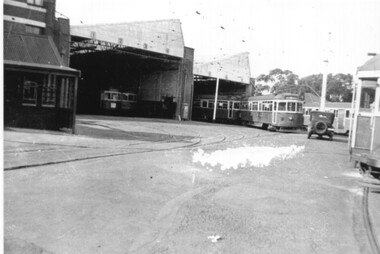
Photograph - Black & White Photograph/s, Keith Kings, Jun. 1948
Black and white photograph of the front of MMTB Hawthorn Depot, June 1948 after the front of the sheds had been rebuilt and the brickwork removed. See image i2 for the rear of the photograph giving details. Notes the "T"shape reflector on the apron of the SW5 tram and that they were a wartime measure, being removed in the late 1940's and by 1951. Keith Kings photograph No. B(k)(8) Printed on Kodak Xralife paper.trams, tramways, hawthorn tram depot, depots -
 Melbourne Tram Museum
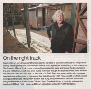
Newspaper, "On the right track", c2010
Newspaper clipping from a local Sandringham - Black rock newspaper printed on gloss paper titled "On the right track" about the recovery and storage of a former Black Rock horse tram that had been used as a tool shed. Quotes Carolyn Brown of Black Rock House. Has a photo of the vehicle at the house in the yard? Not dated - c2010? Following a query, advised that the body is now (2017) at Bylands. See image 5649i1.jpgtrams, tramways, black rock, horse trams -
 Flagstaff Hill Maritime Museum and Village
Photograph - Historical, maritime, Brookes' Photographic Union, Harbour Works, Warrnambool, 1891
This photograph records the making and placing of the concrete blocks for the construction of the Warrnambool Breakwater in the Warrnambool Harbour, completed in 1890. Each block weighed 20 to 30-plus tons. The huge Titan steam powered crane in the photograph played a massive role in the construction. It was able to lift the concrete blocks with its overhanging, counterbalanced arm and roll on its wheels along the rails to the required position. It then lowered the blocks into position on the concrete foundation already laid on the seabed. There are many details in the photograph that help to tell other aspects of Warrnambool's history. It appears that the photograph was once owned by B. Fisher. The photograph is part of the Western Victoria collection produced in 1891 by Brookes' Photographic Union in Victoria. Brookes' Photographic Union was a collaboration of two brothers, Frederick Augustus Brookes and his brother Albert Edward Brookes. Frederick arrived in Victoria in the early 1880's. He and Albert formed the organisation to produce collections of photographs including the districts of Geelong, Gippsland and the Western Victoria.This photograph was taken during the construction of the Warrnambool Breakwater and published the year after it was completed. The project began with the Government of 1874 approving the plan, and was completed in 1890. The image records a snapshot of the construction of the Warrnambool Breakwater, a construction that changed the history of the Port of Warrnambool, Photograph, sepia coloured rectangular shape, mounted between two sheets of cream card. Border of photograph is decorated with pen lines and design in corners. Subject is the Warrnambool Breakwater construction with the Titan steam crane on rail lines, concrete blocks, a windmill and tanks, sheds, and a multi-storey building in the background. Produced by the Brookes' Photographic Union, Western Victoria. Inscriptions are on the reverse, on two stickers, a printed white label and a handwritten name.Stickers: "137" "F.Pn 61/2-74" Label: "WESTERN VICTORIA / BROOKES' PHOTOGRAPHIC UNION / HARBOUR WORKS, / WARRNAMBOOL." "The subject of this picture is the making of concrete blocks for the Breakwater. These blocks weigh from 20 to 30 tons each, and are lifted about by the large piece of machinery seen in the picture." Hand written: "B. Fisher"flagstaff hill, flagstaff hill maritime museum and village, warrnambool, maritime museum, maritime village, great ocean road, shipwreck coast, western district, western victoria, brookes' photographic union, frederick brookes, albert brookes, photograph, warrnambool harbour, harbour works, concrete bolcks, breakwater, warrnambool history, breakwater history, 1891, lady bay, port of warrnambool, b. fisher, titan crane, steam crane, concrete blocks -
 Ballarat Tramway Museum
Photograph - Colour Photograph/s set of four, Carolyn Dean, 8/11/1997 12:00:00 AM
Group of four colour postcard size photographs taken on 8/11/1997 of the visit of the Vintage Car Club to Ballarat. 764.1 - Horse tram No. 1 and rear of ex MMTB Mark III bus, No. 592 on depot area. 764.2 - as for 764.1 764.3 - from access road in front of shed, showing bus No. 592, Tower Truck, Horse tram and No. 26. 764.4 - Tram No. 26 with Travis Jeffrey and John Phillips.On rear of each photo in ink "8.11.97"btm, vintage car club, tram depot, mark iii bus no. 592, tram 1, 26 -
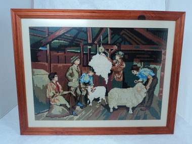 National Wool Museum
Textile - Tapestry, Monica Baker, Weighing The Fleece, 2001
Hand-stitched tapestry by Monica Baker in 2001. Tapestry represents part of the family history of working in the wool industry as owners of a sheep property for five generations. The family ran Corriedale sheep in Lismore, Victoria.Brown timber framed woollen tapestry with cream mounting board. Tapestry is handstitched and features various colours. Scene depicts four men and a woman in a shearing shed. Two of the men are handling sheep, one man is weighing a fleece while the last man and woman look on. Back of frame has a horizontal hanging wire, a framers stamp at the bottom centre and a handwritten creators name and date at the top right corner.Back: [handwritten] "WEIGHING THE FLEECE" / BY MONICA BAKER / 02/03/01lismore, sheep breeding, tapestry, monica baker, shearing, hand made, corriedale -
 Ballarat Tramway Museum
Photograph - Colour Photograph/s, Carolyn Dean, Mar. 1999
Set of 23 photographs taken by Carolyn Dean between 6/3/1999 and 16/4/1999 of the Begonia Festival operations and moving the ex SEC bike shed to Bungaree. On Kodak paper. 1094.1 - Group of tramway staff at Gardens Loop - used in May 1999 Fares Please! .2 - tram 40 at loop .3 - sign boards used in 1999 Begonia festival .4 - Welding joint 2-3 road - Warren Doubleday and Gary Wood .5 - ditto with Alastair Reither .6 - Fixing fence at Bungaree - John Phillips .7 - ditto .8 - ditto .9 - site for the hut to go at Bungaree .10 - ditto .11 - treated pine posts for stumps .12 - checking the layout - John Phillips .13 - cutting fire wood .14 - trimming trees .15 - Dismantling the roof on the shed at Ballarat East - John Phillips and Simon Jenkins .16 - roof off .17 - ditto .18 - the moving team - used in May 1999 Fares Please - see caption for people .19 - Lifting the shed out of position .20 - ditto .21 - ditto .22 - surveying the foundations - Peter Winspur, John Phillips and Alastair Reither .23 - ditto .1 > .3 - 6/3/1999: .4 & .5 - 7/3/1999: .6 > .13 - 20/3/1999: .14 - 21/3/1999: .15> .23 - 16/4/1999 See also Reg. No. 1095 and 1101 for next stage of the move. On rear of each photo in blue ink is date in the upper edge and on lower edge "Photo by Carolyn Dean"btm, sec bike shed, begonia festival, track repairs, tram 40 -
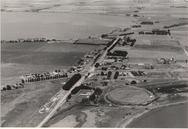 Lake Bolac & District Historical Society
Black and white photograph, Aerial view of Lake Bolac township, circa 1970
Lake Bolac township, 1970. This picture shows the 2nd football oval, tennis courts, golf course and racecourse (front-right) above the salt lake and the Lake Bolac Common (front-left). The Primary School is still on its original site between the oval and the Ararat road. The High School is beside the fresh-water lake (centre back) and to its left are the early caravan park and bowling club. The Aquatic Club shed can just be seen behind the lake bank. Photograph taken by Lewis Wills.lake bolac, football oval, tennis courts, race track, golf course, bowling club, caravan park, aquatic club shed, primary school, high school -
 Rutherglen Historical Society
Image, c1990
This photograph is of the viewing room inside the building, this side with windows overlooking the machinery and a video screen with a switchboard to run the video. One of a series of photographs of the Rutherglen Gold Battery. Its purpose was to crush quartz from nearby quartz reefs and extract gold from within. The battery was erected in 1908 and consists of a five-head battery, Wilfrey table, Bergin pan, portable steam engine and shed. The battery was restored in 2011/12 and can be viewed daily between 9.00am and 5.00pm. See website for details.Colour photograph of the interior of a building showing two large windows and a video screen on a corrugated iron wall.gold battery, gold processing -
 Rutherglen Historical Society
Image, c1990
This photograph is of Battery Box, showing the mouth where quartz is fed in. The five stamper rods can also be seen. This is one of a series of photographs of the Rutherglen Gold Battery. The battery's purpose was to crush quartz from nearby quartz reefs and extract gold from within. The battery was erected in 1908 and consists of a five-head battery, Wilfrey table, Bergin pan, portable steam engine and shed. The battery was restored in 2011/12 and can be viewed daily between 9.00am and 5.00pm. See website for details. Colour photograph of a large piece of machinery inside a buildinggold battery, gold processing -
 Whitehorse Historical Society Inc.
Photograph, Mitcham Railway Station construction 2013-14
The original Mitcham Station was opened on 25th December 1882. Until the 1970s a shunting yard and goods shed existed where the southern car park is now. Tracks remained embedded in the car park for many years. In 1979 boom gates were provided at both Mitcham Road and Rooks Road. From December 2009 to January 2010 Mitcham Railway Station was used as a bus interchange when the realignment of tracks and construction of a new station occurred at Nunawading. The new Mitcham Station opened on 25th January 2014.Coloured photographs of the construction of the underground railway station at Mitcham in 2013-14 and the opening in 2014.mitcham railway station construction 2013-14, mitcham railway station opening 2014, mitcham railway station, rialway stations -
 Mt Dandenong & District Historical Society Inc.
Photograph
The Wenborn family acquired Ferguson's Lot 19 of the Village Settlement where the original Mount Dandenong School was opened in a shed. WH Collom owned the land after Ferguson and then it passes to the Wenborns. This photograph, taken c1942, shows Ivy Wenborn with her daughters Mary and Joan. John Lundy-Clarke grew up in the Kalorama/Mt Dandenong area and later in life (1972-74) began to write a comprehensive history of the area working from an original settlement map in an effort to cover all areas.Black and white photograph of a woman nursing a young girl Another young girl is seated at her right.Behind is a view of trees and a house. Handwritten inscription on reverse by John Lundy-ClarkeWenborn Family. Looking across what is now Kalorama Park showing Norman Jeeves' house behind the hedge to the left of the child.wenborn, ivy wenborn, mary wenborn, joan wenborn, norman jeeves, kalorama park, jeeves -
 Mt Dandenong & District Historical Society Inc.
Photograph, Mount Dandenong Primary School 1997, 1997
The first Mt Dandenong State School opened in a shed on the property of William Ferguson on the corner of Blythe and Old Coach Roads. The first teacher was Miss Ethel Gruber who opened the school on May 11th, 1897. It wasn’t until 1901 that the school shifted over the road into an old school building that was moved up to the new site from Ringwood. All the old buildings were demolished to make way for a new school that opened in 1991. There are many old, European trees that were planted in the grounds during Arbor Days. Students standing at base of large Sequoia Tree in grounds of school in 1997, centenary year.mount dandenong, mt dandenong school, sequoia, centenary, trees -
 Mt Dandenong & District Historical Society Inc.
Photograph, Mt Dandenong Primary School in Snow 1995, 1995
The first Mt Dandenong State School opened in a shed on the property of William Ferguson on the corner of Blythe and Old Coach Roads. The first teacher was Miss Ethel Gruber who opened the school on May 11th, 1897. It wasn’t until 1901 that the school shifted over the road into an old school building that was moved up to the new site from Ringwood. All the buildings were demolished to make way for a new school that opened in 1991. Up until the later 2000s snow fell at the school several times a year. Three children playing in snow at the front of Mt Dandenong Primary School 5th September 1995. The snow lasted three days.mt dandenong school, snow, mt dandenong -
 Friends of Westgarthtown
Painting, John Borrack, Ziebells, German Lane, South View
Painted from Gardenia Road. The extensive farm complex on the right. (Western side of Gardenia Road). was demolished in 1972 for housing development. Buildings shown are cowshed, hay barn, engine shed and stables. Painted in the late afternoon, the lengthening shadows and lowering sky, could presage the ominous fate awaiting the farm with development. The Ziebell Farm was known as “The Pines†and sadly none of the many that proliferated there remain. Today they would be equivalent to those at the cemetery, having been planted at the same time. Provenance: John Borrack CollectionWatercolour depicting Ziebell Farmhouse from the north, Thomastown and Mernda. In gold frame with cream border.Artist signature: John Borrack; 70's Ziebells German Lane South Viewillustrations, watercolours, john borrack, ziebell, watercolour, painting -
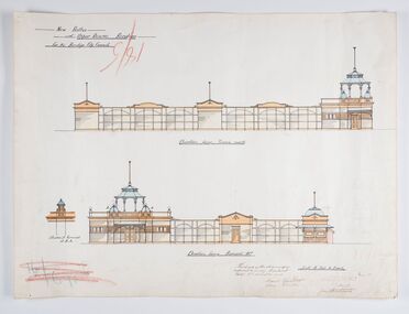 City of Greater Bendigo - Civic Collection
Work on paper - Architectural Drawing, City of Bendigo, New Baths at Upper Reserve Bendigo for the Bendigo City Council, 18th November 1912
The 'New' City of Bendigo baths also known as 'The Baths' were opened on 26th February,1913 at a cost of £2000. These baths made use of an existing dam and had men only and ladies bathing areas as well as a 'paddling paddock' for young children. This set of plans is for the Men's Bathing shed which serviced the men's bathing area adjacent to the still existing tennis courts on Barnard Street. In 1958 the Municipal Baths were replaced by an Olympic Pool and £17,000 was raised by public subscription towards this pool’s construction. Ink, pen, pencil and watercolour architectural drawing for the proposed new baths at the Upper Reserve on Barnard Street, Bendigo.New baths / at Upper Reserve Bendigo / for the Bendigo City Council / Elevation facing tennis courts / Elevation of Terminals at A, A, / Elevation facing Barnard Street / This is one of the drawings /referred to in my contract/ dated 18th November 1912 / Signed Robert J Rogers / (unknown) / Mayor Jas Semmensbendigo swimming club, rosalind park, upper reserve bendigo, faith leech memorial swimming pool, bendigo baths, city of greater bendigo community groups -
City of Kingston
Photograph - Colour, 6 March 1993
Edithvale is a suburb in the City of Kingston. It is located between Aspendale and Chelsea on the Port Phillip Bay and built within remnant areas of the Carrum Carrum swamp. The foreshore precinct comprises a wide sandy beach, with low sand dunes and numerous historic boat sheds. The suburb consists of older style dwellings and former holiday houses, combined with mid-century housing and newer homes. The large blocks are increasingly subdivided and the existing dwellings demolished to accommodate units and townhouses, thus changing the landscape of the area and reducing the tree canopy.The beachside suburb of Edithvale was previously part of the extensive Carrum Carrum Swamp. The area was once a source of fish and eels for the Mayone-Bulluk clan of the Bunurong people. Over time the area was drained and predominantly devoted to dairy farming and holiday houses. The farms were gradually sold and subdivided with a large number of homes built after World War II and in the 1960s. Edithvale is mainly residential with a shopping strip along Nepean Highway but little significant industry was ever established in the area apart from a plaster works and confectionary factory, both now closed.Laminated aerial colour photograph of Edithvale as viewed from Alexandra Avenue in the north to Ella Grove Chelsea/Edithvale in the south. regents Park Aspendale can be seen in the top left. The area is built-up with residential housing and facilities including Edithvale Primary School, numerous churches and the Edithvale Railway station. Large sections depict the remnant Carrum Carrum swamp. Edithvale Common and the former "Duck Inn" (Melbourne Water/Friends of Edithvale Seaford Wetlands) can be seen. Edithvale Recreational reserve, the valodrome and Edithvale Public Golf Course are prominent. The image shows vacant land in the area now known as Aspendale Gardens and the newer residential section of Chelsea Heights is not developed. A bike path has been established to cover the secondary drain. The Golf Links Court residential development located off Hughes Avenue is a large vacant block.Black type on white adhesive label: 6-3-93 Black type on white adhesive label: 25/9211, 6/3/93, 11.20 am Black type on white adhesive label: 9211 Yellow circular adhesive sticker Black pencil: 9211 6-3-93 arrow pointing Nedthvale, carrum carrum swamp, aspendale, chelsea -
 University of Melbourne, Burnley Campus Archives
Photograph - Colour, Dairy, 1985
Note by T.H. Kneen," After the transfer of the small dairy herd to Glenormiston and later Longerenong the milking shed was modified to serve as a machinery shop. Late in 1990 and early in 1991 it was converted for use as the Horticultural College Centenary Centre and as a new home for the Horticultural Shop. Half the space on ground floor level was devoted to a display "A Centenary of Horticultural Education." The old loft area was fitted out as the office for the Executive Officer for the Centenary Celebrations and the storage of archival material." (In 2009 the shop closed and the archives were removed to the Administration Building.) Colour photograph. Former dairy used as a garage prior to 1990 renovationdairy herd, glenormiston, milking shed, machinery shop, horticultural college centenary centre, horticultural shop, cows, garage, dairy, dairy shed, centenary centre, longerenong -
City of Kingston
Photograph - Colour, Circa 1993
Edithvale is a suburb in the City of Kingston. It is located between Aspendale and Chelsea on the Port Phillip Bay and built within remnant areas of the Carrum Carrum swamp. The foreshore precinct comprises a wide sandy beach, with low sand dunes and numerous historic boat sheds. The suburb consists of older style dwellings and former holiday houses, combined with mid-century housing and newer homes. The large blocks are increasingly subdivided and the existing dwellings demolished to accommodate units and townhouses, thus changing the landscape of the area and reducing the tree canopy.The beachside suburb of Edithvale was previously part of the extensive Carrum Carrum Swamp. The area was once a source of fish and eels for the Mayone-Bulluk clan of the Bunurong people. Over time the area was drained and predominantly devoted to dairy farming and holiday houses. The farms were gradually sold and subdivided with a large number of homes built after World War II and in the 1960s. Edithvale is mainly residential with a shopping strip along Nepean Highway but little significant industry was ever established in the area apart from a plaster works and confectionary factory, both now closed.Aerial colour photograph of Edithvale as viewed from Alexandra Avenue in the north to Ella Grove Chelsea/Edithvale in the south. The area is built-up with residential housing and facilities including Edithvale Primary School, numerous churches and the Edithvale Railway station. Large sections depict the remnant Carrum Carrum swamp. Edithvale Common and the former "Duck Inn" (Melbourne Water/Friends of Edithvale Seaford Wetlands) can be seen. Edithvale Recreational reserve, the velodrome and Edithvale Public Golf Course are prominent. The image shows vacant land in the area now known as Aspendale Gardens and the newer residential section of Chelsea Heights is not developed. A bike path has been established to cover the secondary drain. The Golf Links Court residential development located off Hughes Avenue is a large vacant block.Yellow circular adhesive sticker on plastic Black ink (marker): * (asterisk) Black type on white adhesive sticker: P000108edithvale, aspendale, chelsea, carrum carrum swamp -
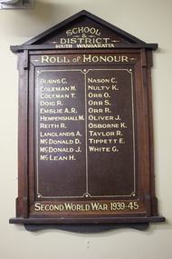 Wangaratta RSL Sub Branch
Memorabilia - Honour Board, South Wangaratta School and District, c1945
The original South Wangaratta Primary School served the district for over 110 years and closed in December 1985 before moving to new premises. When the school closed in 1989 and with the demise of the South Wangaratta Hall due to flooding in the 1990's the Honour Board was wrapped in a blanket and stored in a shed for the best part of 10 years before being donated to the Wangaratta RSL for safekeeping and permanent display. South Wangaratta School and District Honor Board lists names of students who served during WW2Timber Honour Board with two columns consisting of twenty one names in gold paint.School and District South Wangaratta. Roll of Honour. Second World War 1939-45world war 2, south wangaratta, honour board -
 Ballarat Tramway Museum
Slide - SECV Ballarat 43 and welding truck railway level crossing - set of 2, Ron Hood, 12/1970
Photograph by Ron Hood shows the SECV welding truck at the Ballarat Lydiard St level crossing with No. 43 passing on its way to Lydiard St North, December 1970. The welding truck was provided with a trolley pole to power the equipment in order to weld or repair rail joints. Photo taken from the Provincial Hotel. Has the level crossing, Kennedy Murray General Carriers and the Ballarat Goods shed in the view. In the far distance is a SECV truck. See items 2864 and 7700 for other photos of the welding truck.Yields information about the use of the welding truck in Ballarat to repair rail joints or the head of the rail.Set of two colour slides in hanimount cardboard mounts."Ballarat" in ink on one of the slides.tramways, trams, tram 43, level crossing, welding, trucks -
 Emerald Museum & Nobelius Heritage Park
Administrative record - Cash Books, 4 volumes associated with Gembrook Nurseries from 21/08/1895-30/10/1964, 21/08/1895-30/10/1964
Cash book of Gembrook Nurseries (Nobelius Nursery) years 1903 - 1951. The business was purchased by S and L Linton in 1955, but continued to operate under the name of CA Nobelius and Sons. Donated to the museum as a record of a major employer and historical figure of the area. The volumes were found by Clem Worrell in the basement of a shed on the former nursery site. Early volumes include records of personal as well as business expenses incurred by CA Nobelius. Also included are records of tree sales, names of employees and customer details. The cash account books are historically, and socially significant as the entries give an insight into the growth of the company and the details payments from local and other government offices and overseas customers as well as significant companies associations and people. The earlier account books also detail wage payments. Collection of accounting cashbooks kept by the Gembrook NurseryCASH BOOK, various decorative elementsca nobelius and sons, accounting, nobelius nursery, gembrook nurseries, horticulture, s and l linton -
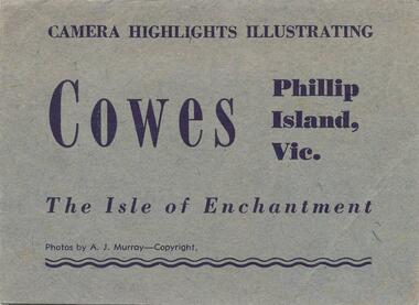 Phillip Island and District Historical Society Inc.
Photograph Folder, 1940's - 1950's approx
8 photographs in a fold-out pack entitled: "Camera Highlights Illsutrating Coes, Phillip Island, Vic. The Isle of Enchentment" Black & White Souvenir Folder of 8 photographs taken around Phillip Island. 1. Summerland Surf Beach 2. Koala in a tree 3. Breakers at The Nobbies 4. The Jetty at Cowes with many people and the Cowes Jetty Shed on left of photo. 5. Seals on Seal Rocks 6. The Newhaven - San Remo Suspension Bridge 7. Penguins coming in after a day's fishing at Summerland Beach 8. The Nobbies and Seal Rocks.Each photograph similar to Physical Description. On back: Postage Rates within the British Empire. Without correspondence, in an unsealed envelope, will be 1.1/2d. If correspondence is added, postage will be 2.1/2d. whether envelope is sealed or unsealed. Foreign rate, 3.1/2d. Front Cover: Camera Highlights Illustrating Cowes Phillip Island, Vic. The Isle of Enchantment. Photos by A. J. Murray.summerland surf beach phillip island, wildlife - koala, wildlife - seals, wildlife - penguins, the nobbies phillip island, cowes jetty phillip island, cowes pier phillip island, suspension bridge phillip island, seal rocks phillip island, stan harris -
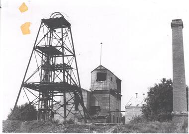 Bendigo Historical Society Inc.
Photograph - DEBORAH GOLD MINE 1930'S
Black and white photograph, copy, of the Big Deborah Gold Mine, possibly taken in the 1930's. Deborah mine was near the junction of Abel and Adam Street, Golden Square. Image shows the mine site, a square brick chimney on the extreme RH side, engine room and stamper sheds in the middle and steel poppet head on LH side. Colour photo of Big Deborah, minus less the winding wheels at the top of the poppet legs.bendigo, mining, deborah gold mine -
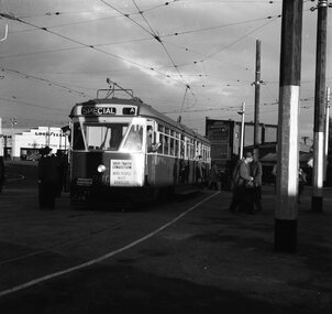 Ballarat Tramway Museum
Negative, Geoff Grant, 25/06/1955 12:00:00 AM
Negative No. N350 and black and white print made by a laser printer (stored in folder ) of tram 980 on AETA tour (Australian Electric Traction Association) on 25/6/1955 entering shed roads at the then new East Preston depot. Tram has AETA tour signs and the slogan "Save traffic congestion, Move People not vehicles". In route number box is letter "A". Negative scanned hi res and imaged updated 22/5/2020.trams, tramways, melbourne, preston depot, aeta tour, tram 980 -
 Ballarat Tramway Museum
Photograph - Black & White Photograph/s, George Netherway, 9/8/1937?
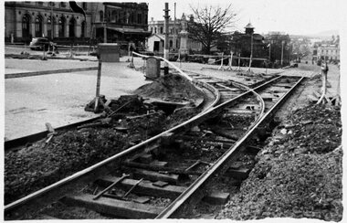
Copy photograph of a small photograph contained within item Reg. No. 587. Photograph is of the point work on the intersection of Sturt St. south side and Lydiard St. North line. No caption on photograph in 587. Photo shows detail of track construction. Work to the east has either been completed or not yet commenced. Shed in photo No. 597 is visible, so could be same date, Hi Res scan of neg used 7-5-2020trams, tramways, ballarat, rehabilitation, sturt st. -
 Kew Historical Society Inc
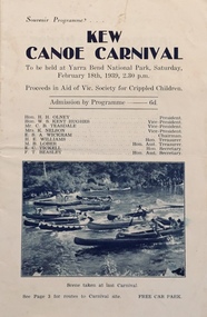
Programme, Kew Canoe Carnival, 1939
An item from an outstanding and diverse photographic collection, assembled by members of the Christian and Washfold families of Kew.10-page souvenir programme for the Kew Canoe Carnival to be held at Yarra Bend National Park on Saturday February 18th, 1939. Proceeds were designed to assist the Victorian Society for Crippled Children. Front cover shows photograph taken at the previous year's carnival. The site of the carnival shown on an internal map was upriver from Macauley's boat house. Photograph on back cover shows canoeists at Kew Boat Sheds, 45 Molesworth Street.kew canoe carnivals, recreation -- river yarra, christian-washfold collection -
 Charlton Golden Grains Museum Inc
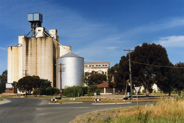
Photograph, Charlton Shire, Charlton Flour Mill, c.1987
A previous mill had operated in Charlton by Mr. W.E. Foreman on the banks of the Avoca River and was acquired in 1919 by Noske Bros. The present Flour Mill was built by Noske Bros and opened in May 1927. It was taken over by the Grain Elevator Board in the 1970s. Colour photograph of Charlton Flour Mill and silos. Intersection of Kaye & Davies Streets in the foreground. One large silver silo and three taller greyish concrete silos to the left. Three other cream coloured silos behind. There are pipes and sheds on top of the silos. There is a cream single story building to the right of the silver silo and a multi-storey building behind with eight window in the upper level. There is a small red brick building on the far left of the photo.w.e. foreman, noske bros, flour mill charlton, business, industry