Showing 2050 items matching " building plans"
-
 Canterbury History Group
Ephemera - Canterbury, 197 Canterbury Road. Mind your own business here, 1/05/2003 12:00:00 AM
Real estate advertisement for the sale by auction of shop in Canterbury Buildings, 197 Canterbury Road, on Thursday 15 May 2003. Includes a coloured photograph of the exterior of the shop and a streetscape, and floor plan.canterbury, canterbury road, shops, victorian style, canterbury buildings -
Canterbury History Group
Ephemera - Unit 1, 12 Chatham Road, Canterbury, [1997]
Real estate advertisement for the sale by auction of Unit 1, 12 Chatham Road Canterbury on Saturday 15 March [1997] Includes sketch of the exterior of building and floor and site plancanterbury, chatham road, home units -
Wonga Park Community Cottage History Group
Plan (Item) - Building Plan, Wonga Park Hall: Plan of new toilets and renovations Probably late 1970s or early 1980s
... Building Plan... Plan Building Plan ... -
 Ballarat Diocesan Historical Commission
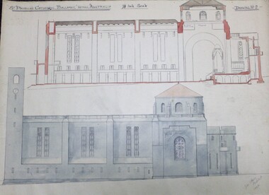
sketch, Architectural rendering for new St Patrick's Cathedral Ballarat
Rendering of proposed new cathedral for Ballarat by J. C. Hawes but never executed. Hawes designed many church buildings in Australia, West Indies, USA and UK. This image is one of a large suite of plans and drawings held in the archive.One of a series of large format sketches and proposed plans for a new cathedral at Ballarat by architect priest J.C.Hawes in 1944.Captioned St Patrick's Cathedral Ballarat, Victoria Australia 1/8 Inch Scale - Drawing No 2- and signed Lower Right John C Hawes Architect 1944. -
 Royal District Nursing Service (now known as Bolton Clarke)
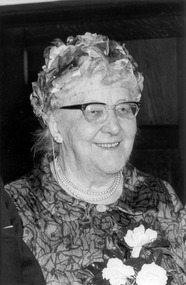
Photograph - Photograph, Portrait black and white, c.1950
Lady Clara R Lowe was elected Honorary Treasurer in 1938, a role she held until being made President of the Melbourne District Nursing Society (MDNS) in February 1950 until late 1951.Lady Clara R Lowe became a Committee member of the Melbourne District Nursing Society (MDNS) and After-Care Hospital in 1937. She became the Honorary Treasurer in 1938, a role she held until being elected as President in February 1950. She led the Committee of the Society in a time when the Victorian Hospital and Charities Commission wished to set up a separate District nursing service throughout Victoria, with the Society involved. The Commission, under the power of the Hospitals and Charities Act, planned to restructure MDNS and the After-Care Hospital. Lady Lowe was involved with these discussions and in the forming, in October 1951, of separate Boards of Directors for the Nursing division, and for the After-Care division Though the Boards would function independently they would be under the same Committee of Management. Now separate buildings were required for the housing of the District nurses and the headquarters of the Nursing division. The Commission became autocratic in this regard and Lady Lowe resigned as President in late 1951 as she felt she could no longer lead her committee without their interference. Black and white photograph showing the head and shoulder view of Lady Clara R. Lowe who is smiling and is slightly turned to her left. She is wearing glasses, and is wearing a close fitting patterned hat over her wavy grey hair. She has a double row string of pearls around her neck and is wearing a patterned grey frock. The petals of held white flowers are seen in front of her frock. melbourne district nursing society, mdns, after- care hospital, lady clara r. lowe, royal district nursing service, rdns -
 Melton City Libraries
Document, The opp. shop song, Unknown
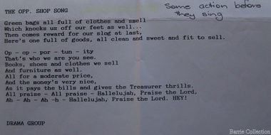
SUMMARY – Uniting Church Op Shop Melton South Opportunity Shop – Brooklyn Road Melton South Est 1975 Former Methodist Church. The Opportunity Shop – Established 1975 by Edna Barrie 1992 Typed copy by Cath MacLean 2011 [Scots’ Presbyterian Church 1964] Additional information to the above summarised from Edna Barrie’s draft notes. Copied by Wendy Barrie January 2012, noting the information might be useful for future research. In 1985 the need for more shop space became apparent. Les [Bone] had plans drawn up (Surv 12/8/84) and approved by the Melton shire Council for a storeroom extension (17.800 x 9500) 1986 the small ancillary rooms at the rear of the timber church were demolished allowing the concrete slab to be laid. The building was completed in 1987. By the early 1990s the old timber Church had deteriorated, this lead to it being demolished in 2/11/1993. It was replaced with a new building containing a Pastoral Office, a meeting room and a furniture and homeware section. It was dedicated by Rev Ian Hickingbotham at 11am Sunday 5th June 1994. Service Awards were presented to 75 Opportunity Shop Volunteers by Rev Ian Hickingbotham. Funds have helped to pay for pastoral work, youth work and extra pastoral support. Lyrics for the Opportunity Shop which was located at the former Methodist Church. council, churches, local identities -
 Melton City Libraries
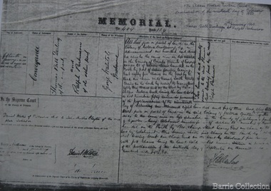
Document, Darlingsford land title, 1863
Thomas Bell Darling purchased 176 acres from the Toolern Creek to Ferris Road. A house and bluestone barn/stables were built. The property was owned by Ralph Parkinson, followed by Richard Manning. SUMMARY – Darlingsford – Auction 1910 Darlingsford – Auction 1910 Melton Express October FRIDAY, October 28th At Three O’Clock At the RAGLAN HOTEL, MELTON SUBDIVISIONAL SALE of the DARLINGSFORD ESTATE, MELTON. Having a long frontage to the TOOLERN CREEK. In the Estate of the late RICHARD MANNING’ W. S. KEAST and L.A. FAIRBAIRN & CO., Auctioneers (in conjunction). Have received instructions from R.F. and J.L. Robertson, executors of Richard Manning deceased to offer by Public Auction, property almost adjoining Melton township, and having a frontage to the Toolern Creek, subdivided in to four lots as under:- Lot 1. – The homestead block containing 176 acres, being portion A, section 11, parish Kororoit together with the improvements, which consist of a 6-roomed stone house, milking shed, dairy, U.G. tank. Lot 2 – 177 acres 2 rood 23 perches, being Crown portion B of section 11 parish Kororoit. This block adjoins the homestead and is partly fenced. Lot 3 – 187 acres, Crown allotment C, section 11, parish Kororoit. adjoining the above lot. Lot 4 - 157 acres 1 rood 27 perches, being Crown allotment 9, section 12, parish of Kororoit. This block is only divided from the above lots by road, and adjoining Messrs. McVean and Gaitskill’s properties. This is one of the best known properties in the Melton district as a cultivation an grazing form, and its close proximity to the township makes it a very valuable, and portion of which could be cut into township blocks and should command a ready sale. For absolute sale. Terms- one fifth cash, one fifth in eight years, balance in 7 years with interest a the rate of 4 1/2 percent. Plan on application For further particulars apply W.S. KEAST, 610 Collins street, Melbourne; and L.A. FAIRBAIRN & Co., St James-buildings, Williams street, or at Bacchus Marsh; and as to the title, Dugdale and Creber, St. James-buildings, William Street Melbourne. Express November 5, 1910 On Friday last, Mr W.S. Keast and Messrs L.A. Fairbairn & Co., in conjunction, offered at the Raglan the Manning Estate known as Darlingsford, comprising of 700 acres, divided into four lots. Lot 4 was submitted first and passed in at L8 per acre. Lot 1 was then put up and went up to L13 per acre, at which it was also passed in. Lot 3 was next offered, and there being no bid was also passed in. Lot 2 was not offered. Express March 18, 1911 The Manning Estate of Darlingsford 600 acres was sold to Mr. Ernie for an undisclosed price. Note: Map KOROROIT COUNTY OF BOURKE Crown Grant Section 11 Portion A Thomas. B. Darling 176 . 0 . 0 acres on 29.3.1853 Lot 1 Portion B A. Russell 170 . 0 . 0 acres on 29.3.1853 Lot 2 Portion C Peter Inglis 176 . 0 . 0 acres on 29.3.1853 Lot 3 Section 12 Portion 3 P. Inglis 157 . 1 . 27 acres on 17.17.1863 Total 176 170 176 157. 1.27 679 . 1.27 acres November 5th 1910 On Friday night last Mr W S Keast and Messrs L A Fairbairn & Co, in conjunction offered at the Raglan Hotel the Manning Estate known as Darlingsford, comprising of 700 acres, divided into four Lots. Lot 4 was submitted first, and was passed in at L8.0.0. per acre. Lot 1 was then put up and went to L13.0.0. per acre at which it was passed in. Lot 3 was next offered, and then Lot 3 was next offered, and then being no bid was passed in. Lot 2 was not offered. October 22nd Notice of sale. 700 acres of splendid land close to the railway station. Divided onto 4 Lots 3 of which are maiden land and the whole of the acres is chocolate soil. No 1 Lot belonged to the late Mr Ralph Parkinson, and for years was liberally supplied with manure and crushed bones, and is capable of producing many crops.. The property being sold to wind up the Estate. Gisborne Gazette Friday December 17th 1911 Mr Sharp has sold his farm at the back of the township to Mr. E Barrie; price L15/10/ per acre. Agreement between Thomas Bell Darling and Ralph Parkinsonlocal identities -
 Melton City Libraries
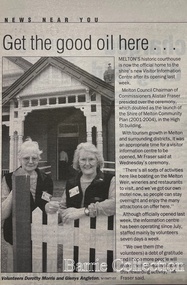
Newspaper, Get the good oil here…, 2001
"A court was established in Melton by 1864, when the first recorded case was heard before Mr BA Porter JP, with Mr A Carroll as the Clerk of Courts. John James was convicted of being drunk, for which he was fined five shillings or 24 hours imprisonment. The court was held in the ‘long room’ of the old Melton Hotel, before moving to rented accommodation at the Raglan Hotel, and finally to the Roads Board office. Tenders for construction of the present building were called for by the Public Works Department on 13th February 1892. The architect Samuel Edward Brindley was born in Birmingham, England, in 1842. He was articled to the local architect, J.R. Botham, FRIBA, before emigrating to Victoria where he was employed as an architect in the Education Department from 18 August 1873. With the amalgamation of the architectural branch of the Education Department with the Public Works Department in 1884, Bindley was placed in charge of Victorian government building design for the North-Western District. In 1975, the Melton and District Historical Society became concerned at hearsay that the court house was to be demolished to make way for carparking space. Melton had been declared a ‘satellite city’ and was developing rapidly. A new shopping centre had recently been built at a setback of 60 feet (c.18 metre) from 323-329 High Street, and the court house, together with the adjacent weatherboard police station, had been left standing alone. A new police station was planned, and the weatherboard police station was subsequently demolished. In its nomination of the building for National Trust classification the Society argued that the Court House was ‘the best of two early buildings left in the main street’ (the other being a bluestone hotel) and that its loss would be ‘tragic’. However the nomination was unsuccessful, the National Trust at the time judging that it was of no particular ‘distinction’ or ‘antiquity’. The building continued to be used as a court house at least until 1991 when the Department of Housing and Construction (formerly the PWD) conducted a heritage study of court houses. By this time Federation-era architecture had achieved acceptance within the heritage movement. The building was recognised as being ‘the only surviving example in brick of the Federation Queen Anne style which was used for court houses only twice.’ Twenty years later when it was proposed to modify the eastern façade of the building to accommodate a café, the M&DHS was again concerned. This time the National Trust objected that the proposed extension would be an over-development of the site, and questioned the changes to the interior court room furnishings and fittings. The site never appears to have been nominated to the Victorian Heritage Register. It has since been converted into the Shire of Melton Tourist Information Centre". Opening of the Visitor Centre in Meltoncouncil, local architecture -
Tarnagulla History Archive
Photograph - Photograph: Company's Dam and Flour Mill, Tarnagulla, c. 1880 - 1920
Williams Family Collection. On the 20th December 1873 it was reported in the Tarnagulla Courier that arrangements were being made for the erection of a steam flour mill at Tarnagulla. Mr Bristol had purchased the necessary plant which would be erected with as little delay as possible. The site chosen was the premises occupied previously by Mr John Pierce, grocer and wine and spirit merchant, at the corner of King and Commercial Road. These premises were incorporated in the mill building. Suitable buildings for receiving and storing grain and flour had been erected already. On 10th January, 1874 an advertisement in the Courier called for tenders from masons, bricklayers and carpenters for the erection of a flour mill at Tarnagulla for H. C. Bristol, Esq. with all enquiries to be made from G. Minto, Engineer. In December 1881 the proprietors made a request to the Tarnagulla Borough Council for permission to lay pipes to the Municipal Dam, which was generally known as the Company's Dam, and to obtain water from the dam for milling purposes. This was granted. Steam was got up for the first time on 30th of March, 1882. A large quantity of wheat was stored ready for milling. Just prior to 29th of April 1882 the boiler at the mill burst, as the result of which two men, J. H. Smith and W. Hargreaves died and H. Joyce Bousfield, senior and junior, were seriously injured. The mill commenced operations on 13th June, 1882 with Mr W Fitzgerald as manager. The price offered for wheat was thirty-seven pence per bushell. It operated with grinding stones until considerable renovations were done in the early part of 1899 when new rollers and more up to date equipment installed. The mill was then known as the Tarnagulla Flour Mill Co., with Thos. Comrie as proprietor, Mr Fitzgerald was still manager, and Mr T. Leonard was the traveller. Much new equipment was put in and each of the three floors had different processes. The rollers were on the ground floor, the purifiers and elevators reel were on the second floor, plus the clean wheat bin directly over the Ganz rollers. On the top floor was the chop reel, bran reel, inter-elevator reels, brush machine cyclone sack hoist, dirty wheat shaker, clean wheat bin, dust rooms and also double damping rooms. A plant was also erected for the making of an improved quality of wheaten meal, for which purpose special machinery was procured and a pair of stones was left for grinding the meal. A complete plant for the crushing of oats etc was also erected. The driving power of the mill was supplied by a new engine complete with 16 inch cylinder, manufactured and erected by Bousfield & Co. of Eaglehawk. It was fitted with Pickering governors, connected with the cylinder was a super heater. The boiler was tested and all connections etc. overhauled, with much of it being completely renewed. There was a complete network of belts, spouts, elevators etc. all over the building, all conveniently placed. The plans etc for the new plant were drawn up by Mr J. Kilborn, manager of the firm of Bodington & Co., engineers and millwrights of Carlton, which supplied the whole of the machinery, excepting the engine. The work of erection was carried out by Mr Kilborn and his assistants to the entire satisfaction of Mr Comrie, who had gone to considerable expense to bring the mill to a completely up-todate machine, fitted with all of the most modern appliances available. An advertisement on May 6th, 1899 read: "Tarnagulla Flour Mill Co., Patent Roller Flour. Also their Digestive Wheaten Meal specially prepared for Porridge or Bread." In January 1901, 6000 bags of wheat were received weekly at the mill and it was a common sight to see the streets lined with wagons. In May 1902 the mill was lighted by gas and in July 1906 an application was made to the Tarnagulla Borough Council for permission to lay a tram track from the mill to the Railways Station. Council was agreeable to this provided suitable plans were submitted. In 1913, 15,000 bags of wheat were bought at three shillings and four pence per bushell. In January 1914 the mill was renovated. At this time 1500 bags of wheat were coming in daily, with 20,000 bags in storage. On 15th December, 1917 the mill was advertised for sale, to be sold on Friday, 21st December,.1917, on behalf of the Estate of the Late Thomas Comrie, who had died on 4th August, 1910. The Courier at that time recorded him as being responsible for the building of the mill and with being the sole proprietor. The mill was closed, apparently, for a short period. The Courier reported on 13th of September, 1918 that the mill had been sold to Mr O. Albert of Talbot and that it would re-open. An advertisement read: ALBERT. O. & SON, MILLERS. During 1920 the mill was closed and pulled down. It was later re-erected at Mildura where it operated for many years. (by Donald Clark)Monochrome photograph depicting view of Company's Dam and the flour mill in Tarnagulla. Handwritten on reverse: 'J. Caldwell and photographer's stamp 'C. Bock Photo Tarnagulla'.tarnagulla -
Tarnagulla History Archive
Postcard - Photographic postcard: Company's Dam and Flour Mill, Tarnagulla, c. 1880 - 1920
Williams Family Collection. On the 20th December 1873 it was reported in the Tarnagulla Courier that arrangements were being made for the erection of a steam flour mill at Tarnagulla. Mr Bristol had purchased the necessary plant which would be erected with as little delay as possible. The site chosen was the premises occupied previously by Mr John Pierce, grocer and wine and spirit merchant, at the corner of King and Commercial Road. These premises were incorporated in the mill building. Suitable buildings for receiving and storing grain and flour had been erected already. On 10th January, 1874 an advertisement in the Courier called for tenders from masons, bricklayers and carpenters for the erection of a flour mill at Tarnagulla for H. C. Bristol, Esq. with all enquiries to be made from G. Minto, Engineer. In December 1881 the proprietors made a request to the Tarnagulla Borough Council for permission to lay pipes to the Municipal Dam, which was generally known as the Company's Dam, and to obtain water from the dam for milling purposes. This was granted. Steam was got up for the first time on 30th of March, 1882. A large quantity of wheat was stored ready for milling. Just prior to 29th of April 1882 the boiler at the mill burst, as the result of which two men, J. H. Smith and W. Hargreaves died and H. Joyce Bousfield, senior and junior, were seriously injured. The mill commenced operations on 13th June, 1882 with Mr W Fitzgerald as manager. The price offered for wheat was thirty-seven pence per bushell. It operated with grinding stones until considerable renovations were done in the early part of 1899 when new rollers and more up to date equipment installed. The mill was then known as the Tarnagulla Flour Mill Co., with Thos. Comrie as proprietor, Mr Fitzgerald was still manager, and Mr T. Leonard was the traveller. Much new equipment was put in and each of the three floors had different processes. The rollers were on the ground floor, the purifiers and elevators reel were on the second floor, plus the clean wheat bin directly over the Ganz rollers. On the top floor was the chop reel, bran reel, inter-elevator reels, brush machine cyclone sack hoist, dirty wheat shaker, clean wheat bin, dust rooms and also double damping rooms. A plant was also erected for the making of an improved quality of wheaten meal, for which purpose special machinery was procured and a pair of stones was left for grinding the meal. A complete plant for the crushing of oats etc was also erected. The driving power of the mill was supplied by a new engine complete with 16 inch cylinder, manufactured and erected by Bousfield & Co. of Eaglehawk. It was fitted with Pickering governors, connected with the cylinder was a super heater. The boiler was tested and all connections etc. overhauled, with much of it being completely renewed. There was a complete network of belts, spouts, elevators etc. all over the building, all conveniently placed. The plans etc for the new plant were drawn up by Mr J. Kilborn, manager of the firm of Bodington & Co., engineers and millwrights of Carlton, which supplied the whole of the machinery, excepting the engine. The work of erection was carried out by Mr Kilborn and his assistants to the entire satisfaction of Mr Comrie, who had gone to considerable expense to bring the mill to a completely up-todate machine, fitted with all of the most modern appliances available. An advertisement on May 6th, 1899 read: "Tarnagulla Flour Mill Co., Patent Roller Flour. Also their Digestive Wheaten Meal specially prepared for Porridge or Bread." In January 1901, 6000 bags of wheat were received weekly at the mill and it was a common sight to see the streets lined with wagons. In May 1902 the mill was lighted by gas and in July 1906 an application was made to the Tarnagulla Borough Council for permission to lay a tram track from the mill to the Railways Station. Council was agreeable to this provided suitable plans were submitted. In 1913, 15,000 bags of wheat were bought at three shillings and four pence per bushell. In January 1914 the mill was renovated. At this time 1500 bags of wheat were coming in daily, with 20,000 bags in storage. On 15th December, 1917 the mill was advertised for sale, to be sold on Friday, 21st December,.1917, on behalf of the Estate of the Late Thomas Comrie, who had died on 4th August, 1910. The Courier at that time recorded him as being responsible for the building of the mill and with being the sole proprietor. The mill was closed, apparently, for a short period. The Courier reported on 13th of September, 1918 that the mill had been sold to Mr O. Albert of Talbot and that it would re-open. An advertisement read: ALBERT. O. & SON, MILLERS. During 1920 the mill was closed and pulled down. It was later re-erected at Mildura where it operated for many years. (by Donald Clark)Photographic postcard, front image depicting view of Company's Dam and the flour mill in Tarnagulla. Handwritten on reverse: 'A Merry Christmas and a Happy New Year, E. Bool' and photographer's stamp 'C. Bock Photo Tarnagulla'.tarnagulla -
Canterbury History Group
Document - Lowell Chen, Urban Planning Special Committee - City of Boroondara, 1/12/2011 12:00:00 AM
Kew and Hawthorn. Further Heritage Investigations. Attachments for item: UPC3. Individual Heritage Overlays: Authorisation and Exhibition of Planning Scheme Amendment. Summary Report Prepared for the City of Boroondara. Item 3 Emulation Hall, Canterbury. pages 174-177. Includes black and white photographscanterbury, rochester road, dunstan reynolds & partners, egyptian revival style, emulation hall, historic buildings, masonic lodges -
Canterbury History Group
Map - Maling Road Built form Map, Ciy of Boroondara, 2015
Map copied from the 'Urban Planning Special Committee Agenda' Design and Development Overlay- Schedule 23 showing heritage property on Maling Road. Produced by The City of Boroondaracanterbury, maling road, heritage buildings, city of boroondara, urban planning special committee agenda, maps -
Canterbury History Group
Newsletter - Happy Apple News, Canterbury Primary School Newsletter
Five copies of the Happy Apple News for 1989. Contains news of the activities of the school community, including the decision to set up a committee to preserve archival material relating to the school and the discovery of the original school bell (manufactured by John Danks & Son, Melbourne) under the building.canterbury, molesworth street, canterbury primary school, newsletters, danks family, guerin> laurent, james> becky, wilcox> tom, boulton> anne, plans, weymouth> j., oak trees, primary schools -
Canterbury History Group
Article, Elgar, Kerrie, A city divided
Article from the Melbourne Weekly, 1995 reporting on the redevelopment of the Canterbury Mansions to offices and the effect this has had on the availability of rooms to rent in the camberwell area. Includes 2 coloured photographs of the exterior of the buildingcanterbury, canterbury road, wattle valley road, canterbury mansions, city of boroondara, public housing, town planning, elgar> kerrie, boarding houses, spivak> gary -
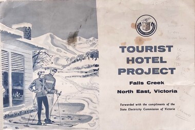 Falls Creek Historical Society
Document - Tourist Hotel Project
State Electricity Commission (SEC) outlined details of a site available for the development of a Tourist Hotel Project in Falls Creek in late 1962/3. SEC estimated that by the winter of 1963 Falls Creek Village would be able to accommodate 500 persons. The site for development was up to 2½ acres adjacent to the Upper Kiewa Valley Road. It envisaged a building able to accommodate about 100 guests. The successful developer would be granted a lease for 45 years at a rent of £300 per annum. Written applications for the lease were to be submitted by 31st March 1963.This item is significant because it documents plans made by the State Electricity Commission to develop the Falls Creek Tourist Area. A folder with a black and white image of skiers outside a hotel on the left. The logo of the State Electricity Commission and text is on the right half of the folder.On right half of cover: Logo of the State Electricity Commission TOURIST HOTEL PROJECT Falls Creek / North East Victoria Forwarded with the compliments of the State Electricity Commission of Victoriafalls creek tourist area, hotel development falls creek, falls creek projects 1963 -
Friends of Ballarat Botanical Gardens History Group
Work on paper - A Future Plan, The Stoddart Statue and the Future of the Collection, c 2010
Author unknown. Significant in detailing a plan for the future of the Statue Collection C 2010.2 photocopies of a pamphlet, printed on both sidesPrinted logo of Clark Conservatory in black and white, by"Lake Wendouree" and words "City of Ballarat".john garner collection, garner, dr, statues, ballarat botanical gardens, ballarat, gardens, thomas stoddart, the stoddart collection -
Friends of Ballarat Botanical Gardens History Group
Work on paper - Manager, Ballarat Botanical Gardens, City of Ballarat, Interview with Ian ROSSITER by John Garner, 26 May 2006, 26 May 2006
Ian Rossiter, City of Ballarat, Manager of Strategy Development and Corporate Projects& Ballarat Botanical Gardens, interviewed by Doctor John Garner for the Friends of the Botanical Gardens Oral History Project.The interview is valuable in giving information and insights of the Manager of the Gardens over fourteen years.All visiblejohn garner collection, garner, rossiter, interview, ballarat botanical gardens, ballarat, gardens, doctor, ian rossiter, horticulture, robert clark centre, fernery, prisoner of war memorial, sequoias, master plan, wetlands, curator's house, statues -
 Friends of Ballarat Botanical Gardens History Group
Work on paper - Structures in the Ballarat Botanical Gardens, Morey Gates, Pergola and Two Lions
01 Gives an account of the Morey Gates and Pergola over time and 02 the Ballarat Courier 16/12/1893 gives an account of the Unveiling of the Two Marble Lions in the Gardens being postponed.Important in the History of the Ballarat Botanical Gardens and as gifts designed in Ballarat and to adorn main entrance to the Gardens01 One half page in point form 02 Ballarat Courier 16/12/1893 02 References written in black biro, 2nd column of page and reference to presentations by Morey and Ham. Ballarat Courier, 18/8/1894.morey gates, pergola in the ballarat botanical gardens. chronology of the gates and pergola, donor of gates and pergola, construction, designers, damage to structures, original plan, mr d. ham mlc, two marble lions in the ballarat botanical gardens, mr e. morey mlc., john garner collection, garner, dr, ballarat botanical gardens, gardens, ballarat -
 Friends of Ballarat Botanical Gardens History Group
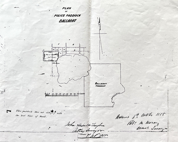
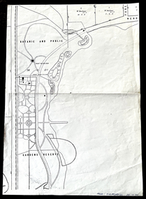
Work on paper - Site of the Ballarat Botanical Gardens, Plan of Police Paddock, Ballarat, 6th October 1855, October, 1855
Plan of Police Paddock, Ballarat, 6th October 1855.In 1855, the Police Paddock occupied the land of the present Ballarat Botanical Gardens.One large white sheet of paper photocopied and folded with a black margin at either end, and the plan and printing in longhand.The Plan is signed and dated by the Acting Surveyor and Assistant Surveyor, October, 1855.john garner collection, garner, dr, police, paddock, plan, map, 1855, ballarat botanical gardens, ballarat, gardens, wendouree, swamp. -
 Friends of Ballarat Botanical Gardens History Group
Work on paper - 1885 Map, Ballarat Botanic and Public Gardens Reserve, 1885
Botanic and Public Gardens Reserve: Early Map.This Plan shows how the Ballarat Botanic Gardens had been set out and part of the Lake Wendouree area in 1885.One large cream sheet of paper, folded in two.bottom of the page on the right in blue biro, "From: Jim Reynolds, 29.10.94".john garner collection, garner, dr, map, early, gardens reserve, ballarat botanical gardens, ballarat, gardens, 1885, public, wendouree parade, w. barbour. -
 Friends of Ballarat Botanical Gardens History Group
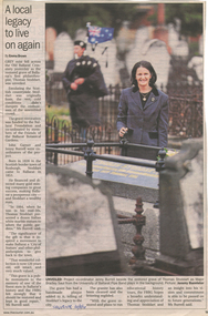
Work on paper - Curators and Benefactors, Visit to Ballarat Old Cemetery, September 2007, September, 2007
A number of Friends of the Ballarat Botanical Gardens investigated the graves of 8 notable Ballarat citizens in 2007 and found Thomas Stoddart's grave to be in a deplorable state. Plans were made by John Garner and Jenny Burrell for the restoration of Thomas Stoddart's grave and the addition of a plaque noting his significant donation of 12 Carrera marble statues to the Ballarat Botanical Gardens.Two pages of typing. p.2 (2 copies). Page 1 and last paragraph of p.2 scanned as one page, to avoid repetition.None.ballarat botanical gardens, doctor john garner, jenny burrell, friends of the ballarat botanical gardens, graves, thomas stoddart, george longley, john lingham, thomas rooney, david ham, j.russell thomson, edward morey, ballarat old cemetery, benefactors, curators, plaque, restoration., 12 carrera marble statues., john garner collection, gardens, ballarat, courier -
Friends of Ballarat Botanical Gardens History Group
Work on paper - Letter to Mr Ford from Doctor Ferdinand von Mueller 28/7/71, Topping the Blue Gum Tree, 28/7/71
This letter was written by Baron Ferdinand von Mueller, Melbourne Botanic Gardens to Mr Ford, Ballarat Town Clerk and is evidence of the advisory role von Mueller played, especially in the 1880's, in terms of the Ballarat Botanical Gardens.Doctor von Mueller was a valuable contributor to the development and planning of Ballarat Public Gardens. He visited Ballarat regularly and was also examiner for the Botany course at the Ballarat School of Mines.Photocopy of the original yellowed letter on two white sheetsPhotocopied letter written longhand in black ink. Left hand side in faint handwriting underlined, "Dr. Mueller, Topping the gum tree, 28/7/71".john garner, doctor, ballarat botanical gardens, melbourne botanic gardens, baron ferdinand von mueller, doctor von mueller, doctor mueller, mr ford town clerk, blue gum trees, botany course school of mines, george longley, benevolent home gardens, director melbourne botanic gardens, victorian government botanist., john garner collection, gardens, ballarat -
 Friends of Ballarat Botanical Gardens History Group
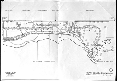
Work on paper - Ballarat Botanical Garden Concept, Masterplan and Management Strategy, Unknown
This map is important in terms of the planning and management of the Ballarat Botanic Gardens The Map adds to our understanding and knowledge of the history of the Ballarat Botanical Gardens 1 page of a map in black and white. the number 44 is circled in pencil on the top righthand corner of the back of the page.john garner, doctor, john garner collection, ballarat botanic gardens, maps, masterplan, management strategy, john patrick, landscape consultants, ballarat city council, friends of ballarat botanical gardens, gardens, ballarat -
Friends of Ballarat Botanical Gardens History Group
Work on paper - Robert Clark Horticultural Centre, Outline Operation Plan 1995, post 1994-1995. [Very likely 1996]
This Outline Operation Plan was an Initial Discussion Draft (not for Broad Circulation) 1994-1995.This Outline Operation Plan shows how activities and the development of the Robert Clark Centre evolved.19 pages. 1st 3 pages are pale green. Title page has the black and green logo entitled "The Conservatory".1st page has 'Thurs. 10 Aug. 700-730pm written in biro on the top lefthand corner. Back page, top righthand corner has 43 written in biro.robert clark centre, the conservatory, robert clark horticultural centre, operation plan, ballarat botanical gardens, friends of ballarat botanical gardens, john garner, doctor, john garner collection, gardens, ballarat -
 Friends of Ballarat Botanical Gardens History Group
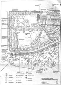
Work on paper - Ballarat Botanical Gardens Master Plan, Final Draft 1995, 1995
This is the "Final Draft" of the Ballarat Botanical Gardens Masterplan in 1995.This document gives some insight into how the Ballarat Botanical Gardens have developed since 1995.There are 6 pages of print and 5 mapsThe City of Ballarat logo is in the centre of p.1.doctor john garner, john garner, john garner collection, friends of ballarat botanical gardens, ballarat botanical gardens, masterplan, gardens, ballarat, drawings -
 Friends of Ballarat Botanical Gardens History Group
Work on paper - Ballarat Botanical Garden Conservation Analysis and Policy, Volume 1, December 1994 and 2002, December 1994 and April/May 2002
The work entitled Ballarat Botanical Garden Conservation Analysis and Policy was prepared for the City of Ballarat.The pages selected give some perspective on the policy and planning of the Ballarat Botanical Gardens in the recent past.14 pages printed on both sides with black and white pictures and one map. Pages are not numbered consecutively; a selection has been made from the work cited in the name and title."Joan" is printed in blue biro in the top lefthand corner of the title page. [Presumably Joan Garner, President of the FBBG].ballarat botanical garden, conservation analysis and policy, city of ballarat, allom lovell & associates pty ltd., conservation architects, john patrick pty.ltd., landscape architects, friends of ballarat botanical gardens, john garner, doctor john garner, john garner collection, gardens, ballarat -
 Bacchus Marsh & District Historical Society
Map, Bacchus Marsh Township and Nearby Districts Maps Volume
This volume of maps is believed to have been compiled by staff at the Shire of Bacchus Marsh and was presumably used to inform and assist Shire staff and Councillors in the carriage of their duties.This collection of maps are significant due to their rarity as many of them are unique maps made for local purposes in the Bacchus Marsh region. They are also of strong research value containing a wide variety of information including landholders, land sales, infrastructure, such as roads, bridges, public, commercial and private buildings, houses, land use, and geographic features over multiple decades from the late nineteen century into the middle part of the twentieth century.One bound volume of maps comprising cadastral maps, (indicating property owners and land boundaries), land plans and real estate auction plans and advertising material, and other maps indicating major infrastructure like proposed roads and irrigation areas. Most of the maps and plans are of Bacchus Marsh and nearby areas but some maps are of nearby towns such as Melton, Ballan and Blackwood. The volume comprises 52 pages. Most pages have a single map or plan pasted onto it but some contain 2 or 3 different maps. There are 81 maps in total. Map 1 Liquidators Sale 1896. Map 2. Woodside Estate Sale 1913. maps, maps bacchus marsh, maps bacchus marsh region -
![Map, Plan of Town Allotments Bacchus Marsh [1891-1897]](/media/collectors/5e461d8021ea67224c82f2a1/items/66acc1c90c778f9f64a3daec/item-media/66acc3990c778f9f64a3e09b/item-fit-380x285.jpg) Bacchus Marsh & District Historical Society
Bacchus Marsh & District Historical SocietyMap, Plan of Town Allotments Bacchus Marsh [1891-1897]
This plan of town allotments in Lerderderg Street and Bennett Street also includes the location of many of the buildings, shops, businesses and houses which were present in the retail and business area of Bacchus Marsh in the 1890s. The precise date of the plan is not known but it must be sometime between 1891 and 1897. The Post Office and the Wesleyan Church are both shown on this plan. Both of these were constructed in 1890. The plan does not show the Baptist Church in Main Street which was constructed in 1898. Hence the date is sometime between 1891 and 1897.This plan of Bacchus Marsh is one of the most detailed visual representations of the location of shops, businesses and houses in the central part of Bacchus Marsh. It provides very precise locations of most of the shops and houses in the town in the 1890s. A single page paper plan showing allotments of land fronting Lerderderg and Bennett Street. Buildings, businesses and houses along most of the streets are identified by hand written annotations. Streets identified on plan: Lerderderg Street - Bennett Street - Main Street - Gell Street - Young Street - Graham Street. Physical boundaries of the map are: North border - Lerderderg Street - South border - Main Street - West border Gell Street - East border - Young Street. The plan is pasted into a bound volume containing 76 maps or plans in total. bacchus marsh victoria maps, shops bacchus marsh -
 Melton City Libraries
Flyer, Melton South Uniting Church Opportunity Centre, 2016
The Opportunity Shop – Established 1975 by Edna Barrie 1992 In 1985 the need for more shop space became apparent. Les [Bone] had plans drawn up (Surv 12/8/84) and approved by the Melton shire Council for a storeroom extension (17.800 x 9500) 1986 the small ancillary rooms at the rear of the timber church were demolished allowing the concrete slab to be laid. The building was completed in 1987. By the early 1900s the old timber Church had deteriorated, this lead to it being demolished in 2/11/1993. It was replaced with a new building containing a Pastoral Office, a meeting room and a furniture and homeware section. It was dedicated by Rev Ian Hickingbotham at 11am Sunday 5th June 1994. Invites to the service of conclusion of the original Uniting Church Opportunity Centre and official opening to the new shop in Melton Southchurches, local identities -
 Melton City Libraries
Document, Minns Family Reunion, 2004
"A perpetual spring in the adjacent creek provided a steady supply of fresh water to the site on which the homestead is built. Although we can not be certain of the identity of the builder, the first stage of ‘The Willows’ homestead appears to have been constructed in the mid 1850s. The house is situated on Crown Allotment No.1 (No Section), Parish of Kororoit, an allotment of 5 acres 3 roods 4 perches. Although it had surveyed the land, the Crown did not offer it for sale until 22nd November 1861, at which time it was purchased by Charles March Williams. (Although the property is directly opposite and immediately adjacent to the Township of Melton, and was sold as ‘Suburban Allotment 33’, it was situated within the Shire of Braybrook rather than the Shire of Melton until 1917.) Considerable improvements had taken place on the land prior to the Crown sale. When CM Williams purchased the allotment in November 1861 he paid £23.5.0 for the land itself, and valued the improvements at £400. Even allowing for some exaggeration by Williams, this is an extremely high valuation for improvements, and must have included a house. Some local research has claimed that in 1858 Williams had taken over the interest of a Mr Parkinson in the property, and that Parkinson built the house upon taking possession of the land c.1855. It was definitely built by 1861, when a map shows a square building on the site marked as ‘House’. The property is important in the district for its association with the establishment of the pound. The district pound had been established in 1854, when George Scarborough of Mount Cottrell (Mt Cottrell Road, south of Greigs Road) was appointed pound-keeper. Scarborough resigned in 1857. The pound was moved to Melton following agitation from local farmers and Charles March Williams appointed pound-keeper on 26th April 1858. Williams, the son of a doctor, had been born in London. Reminiscences of local residents of the time, as recorded in the Express newspaper, note Williams’ success in breeding horses on the property. Sales of up to 60 guineas were noted. Whether this was from Williams’s own stock or from unclaimed pound stock is not made clear. Williams appeared before a government inquiry in 1860 and advocated registration of all stock brands in the State. Williams died in 1862 leaving a widow, Catherine, and five living children aged 15 years to five months. At the time of his death Williams had entered negotiations with one Matthew Devenish and had a mortgage of £100 on allotments 1 and 2, Parish of Kororoit. Catherine Williams was appointed pound-keeper on 2 September 1863, with her eldest son Charles as her assistant. Her tenure was short for on 22nd March 1864 George Minns senior paid Matthew Devenish £135 for allotments 1 and 2 Parish of Kororoit (considerably less than Williams had claimed the property was worth in 1861) and on the same day paid William Tullidge £45 for the adjoining allotments 3 and 4. In April 1867, James Ebden Minns, the newly married son of George senior became the owner of The Willows property having entered into a mortgage arrangement with his father to the extent of £200. At the time George Minns was residing in Kaarimba having left Melton in 1867 for a short trip to England and upon his return having taken up a selection in the Kaarimba district with his son Frederick who had a hotel licence there. James paid out the mortgage on 2-1-1873. James Minns was appointed pound-keeper in 1872; in 1885 the pound was moved elsewhere and Minns purchased the old pound site and added it to his farm. The Willows residence underwent a major change about this time. A two room extension, similar in style but with a lower elevation was added to the original rear of the house with a chimney matching the distinctive originals. Window arrangements did not match the original but became a feature of the façade when the new addition became the front of the building. Six buttresses were attached to the east and west walls of the old building, two to the south wall and the whole rendered with mortar to give the appearance of dressed stonework around the windows. Galvanized iron was placed over the shingles and a verandah added on three sides. By 1876 The Willows was the homestead for a thriving mixed farm of 340 acres of which 156 was rented from a H. Ruck. In October of that year the Australasian travelling reporter visited and reported on the property. In common with the nearly every other property in the district the farm had ‘recently’ (generally within the last two years) abandoned cultivation of crops, and turned over completely to cattle pasture. Butter making was the principal occupation of the farm, which had about 50 head of cattle, a large proportion of which were milking cows. The reporter also noted that a ‘large number of pigs are kept upon this farm and are found to be very profitable stock’. Their manure was used in an orchard and garden in which ‘large quantities of lucerne and prairie grass are grown for the use of stock when ordinary feed is scarce’. Two bores attached to deep brick lined wells supplied water for the house in addition to the farm. A commodious timber barn and necessary sheds had also been constructed. Access to the property was improved following the construction of the bluestone ford across the creek c.1887, when the recreation ground came into use. Prior to this date it may have been that the crossing referred to as ‘Mr Minns bridge’ was used. This appears to have been a flimsy structure and has but two references in Council reports in the Melton Express in the 1880’s. It is believed that in the late 1890’s a timber building was added near the rear of the building to house a kitchen, ablutions and laundry rooms and rooms for seasonal workers. This was attached to the house by means of a trellised walkway using the original front entry to the house (long since the back door). A photograph of this building appears in a local history of Melton. This was demolished in recent decades during the period when the house was tenanted (after the Minns family had left). James Minns son, George, took over the property following his marriage to Alice Walsh in 1903. James and Caroline moved into a house on the former JH Games property at the eastern end of Henry Street. George held the position of Shire Secretary for Melton for 40 years. He was a most prominent member of the community being Secretary to, among others, the Melton Coursing Club, the Shooting Club and the Cemetery Trust. He also rode with the hunting parties who sported across the Plains and were entertained at Mount Kororoit. George and Alice had one son, Norman who followed his father into local government and became Secretary of the Shire of Werribee completing a record term in this position. George retired to Werribee in 1951, where he died in 1965. The National Trust records note that James Ebden Minns and his sons were ‘leading men of the district, Justices of the Peace, and Shire Councillors’. It claims that Sir Thomas Bent was a frequent visitor. The Willows passed into the hands of George’s grandson, Bruce Minns and the property was let for a number of years. In the 1960s it became vacant and was subject to vandalism. Major structural problems arose with the part demolition of the roof, the loss of windows and doors and holes dug into and under the floorboards. The outbuildings were particularly targeted. Following widespread public support, the Shire of Melton purchased the house, with 3.75 acres of land, in 1972. In 1975 the Shire of Melton and the Melton and District Historical Society were successful in nominating the building for National Trust classification, and then the Australian Heritage Commission’s Register of the National Estate. The AHC particularly noted its ‘townscape importance’. It was envisaged that the farmhouse would form ‘a picturesque centrepiece to Melton’s planned … historical park, along with Dunvegan bluestone cottage … and similar structures as they become available.’ In a time of great Melton’s ‘satellite city’ development the Council spelt out its broader vision in its submission to the AHC: ‘Melton is destined to become, by the end of the present century, a city of between 75,000 and 100,000 people. Significant relics of the past, such as ‘The Willows’, regrettably will be rare in that situation. It is essential that sufficient tangible links with Melton’s pioneering days remain to promote in the new community a sense of history and continuity’. Under the direction of ‘The Willows’ Restoration Committee and consultant architect John Hitch, all outbuildings, with the exception of the garage and toilet, were demolished and the dwelling house restored. Finances were provided by the Shire of Melton and the National Estate Grants Program, and considerable amount of voluntary labour was provided by the local community. The orchard was removed, and remaining wooden buildings were relocated to provide an open vista for visitors to the Park. The property was furnished with donations from district families keen to preserve this example of pioneer life in the area. The Willows became the headquarters of the Melton and District Historical Society". Invitation to the family reunion at the Willowslocal identities, pioneer families