Showing 2322 items
matching surround
-
 Bendigo Historical Society Inc.
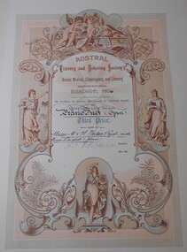
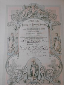
Document - FOSTER AND WILSON COLLECTION: CERTIFICATE AUSTRAL LITERARY AND DEBATING SOCIETY, 1908
Certificate from Austral Literary and Debating Society's Annual Musical Elocutionary & Literary Competitions in Bendigo 1908. Certificate is printed on thick cream cardboard. A wide plain border surrounds a coloured ornate certificate of mainly pink and green. Decoration is of cherubs and muses, fleur de lys, scrollwork and ferns. Certificate for Second Prize was awarded for Piano Duet Under 17 and was won by Miss Kathleen Foster. Certificate is signed by President J E Stapleton and General Secretary Thomas Byrne.AUSTRAL LITERARY AND DEBATING SOCIETYdocument, certificate, music -
 Bendigo Historical Society Inc.
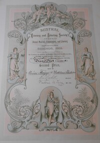
Document - FOSTER AND WILSON COLLECTION: CERTIFICATE AUSTRAL LITERARY AND DEBATING SOCIETY, 1905
Certificate from Austral Literary and Debating Society's Annual Musical Elocutionary & Literary Competitions in Bendigo 1905. Certificate is printed on thick cream cardboard. A wide plain border surrounds a coloured ornate certificate of mainly pink and green. Decoration is of cherubs and muses, fleur de lys, scrollwork and ferns. Certificate for Second Prize was awarded for Piano Duet Under 16 and was won by Misses Kathleen and Mary Foster. Certificate is signed by President Frank ? and General Secretary Thomas Byrne.AUSTRAL LITERARY AND DEBATING SOCIETYdocument, certificate, music -
 Bendigo Historical Society Inc.
Document - FOSTER AND WILSON COLLECTION: CERTIFICATE AUSTRAL LITERARY AND DEBATING SOCIETY, 1903
Certificate from Austral Literary and Debating Society's Annual Musical Elocutionary & Literary Competitions in Bendigo 1903. Certificate is printed on thick cream cardboard. A wide plain border surrounds a coloured ornate certificate of mainly pink and green. Decoration is of cherubs and muses, fleur de lys, scrollwork and ferns. Certificate for Second Prize was awarded for Piano Duet Under 16 and was won by Misses Kathleen and Mary Foster. Certificate is signed by President E Cahill and General Secretary Frederic A King.AUSTRAL LITERARY AND DEBATING SOCIETYdocument, certificate, music -
 Bendigo Historical Society Inc.
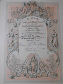
Document - FOSTER AND WILSON COLLECTION: CERTIFICATE AUSTRAL LITERARY AND DEBATING SOCIETY, 1906
Certificate from Austral Literary and Debating Society's Annual Musical Elocutionary & Literary Competitions in Bendigo 1906. Certificate is printed on thick cream cardboard. A wide plain border surrounds a coloured ornate certificate of mainly pink and green. Decoration is of cherubs and muses, fleur de lys, scrollwork and ferns. Certificate for Third Prize was awarded for Piano Duet Open and was won by Misses Kathleen and Mary Foster equal with Misses Buckell and Johns. Certificate is signed by President E Vigau?.AUSTRAL LITERARY AND DEBATING SOCIETYdocument, certificate, music -
 Bendigo Historical Society Inc.
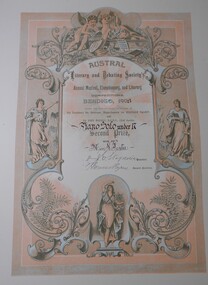
Document - FOSTER AND WILSON COLLECTION: CERTIFICATE AUSTRAL LITERARY AND DEBATING SOCIETY, 1903
Certificate from Austral Literary and Debating Society's Annual Musical Elocutionary & Literary Competitions in Bendigo 1903. Certificate is printed on thick cream cardboard. A wide plain border surrounds a coloured ornate certificate of mainly pink and green. Decoration is of cherubs and muses, fleur de lys, scrollwork and ferns. Certificate for Second Prize was awarded for Piano Duet Under 16 and was won by Misses Kathleen and Mary Foster. Certificate is signed by President E Cahill and General Secretary Frederic A King.AUSTRAL LITERARY AND DEBATING SOCIETYdocument, certificate, music -
 Bendigo Historical Society Inc.
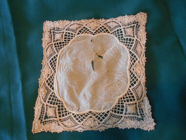
Clothing - MAGGIE BARBER COLLECTION: DARK CREAM SILK AND LACE HANDKERCHIEF, 1800's
Clothing. Deep cream silk centre piece, with scalloped edges - 18 cm x 16 cm. (Scallops 6.5 cm wide). Cream linen bobbin lace - (probably Brussells Lace) surrounds the silk-9cms deep at each corner, 3.5 cms deep at the sides. Fan shapes woven in the lace, emphasize the scalloped centrepiece. Flowers as in 11414.26 and 11414.30a and b, would suggest that this lace has been made by the same maker. Silk centrepiece is damaged, with some splitting of fabric.costume accessories, female, dark cream silk and lace handkerchief -
 Bendigo Historical Society Inc.
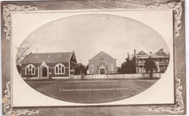
Postcard - CARWARDINE COLLECTION: ST ANDREW'S PRESBYTERIAN CHURCH AND SCHOOL BENDIGO
Sepia colour postcard. Wooden frame surround, image enclosed in oval shape within. Written on bottom of card ' St. Andrew's Presbyterian Church and School Bendigo' Image shows one storey building on LH side, facing street. Building has central doorway, two arched side windows. Other building and church centre and right. See link below for heritage details of buildings: https://ohta.org.au/organs/organs/BendigoStAndrewsUniting.html Receipt number 355/16bendigo, business, carwardine soap and candle -
 Bendigo Historical Society Inc.
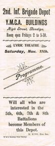
Document - LYDIA CHANCELLOR COLLECTION: LYRIC THEATRE PROGRAMME
A white programme with black print. On the front cover, ' 2nd. Inf. Brigade Depot Y.M.C.A. Buildings High Street, Bendigo. Room open Fridays 2 to 5.30. Lyric Theatre Saturday, Nov. 11th. Programme. Will all who are interested in the 5th, 6th, 7th & 8th Battalions become Members of this Depot. M. King, Hon. Sec. W. & A. Brockley, Print, Bendigo.' On the inside is the programme containing music which is surrounded by advertisements. On the back cover is an advertisement for Warren's, 'the cheapest drapers in Bendigo.'program, music, singing, lydia chancellor, collection, programme, program, ephemeral, music, event, lyric theatre bendigo, entertainment, y.m.c.a. -
 Clunes Museum
Badge
.1 GOLD BADGE HANGING ON NAME TAG (NO NAME) ROUND BADGE WITH PATTERNED EDGES. IN MIDDLE: CLUNES: CLUNES HOSPITAL ESTABLISHED 1871 .2 ROUND BADGE HANGING ON RED TAPE WITH GOLD NAME TAG (NO NAME) ON TAPE. RED CROSS ON MIDDLE OF BADGE. - AROUND EDGES:AUSTRALIAN RED CROSS SOCIETY LONG SERVICE .3 BADGE: RED CROSS ON WITH BACKGROUND DARK BLUE SURROUND GOLD WRITTEN ON BLUE:AUSTRALIAN RED CROSS SOCIETY.. ROUND BADGE WITH RED AND GOLD CROWN ON TOP enid steart, hospital, red cross -
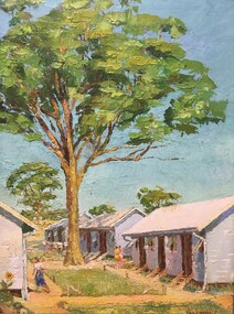 Tatura Irrigation & Wartime Camps Museum
Painting - Painting - Oil, Cesare Vagarini, The Big Tree, 1941
The painting was bought from Cesare Vagarini by Herr Wennagel for "Weihnachten" 1941 (Christmas) for his wife Johanna (Hanno) Wennagel. It was their first Christmas in the Camp. Herr Wennagel made many of the frames for Vagarini's paintings.A large Eucalyptus Tree surrounded by four huts - one on the left, three to the right. Green grass between the huts. A sunflower is growing at the side of the front left hut and a woman wearing a white shirt and blue skirt is seen entering the hut. Two women, one in pink and one in yellow are standing on a pathway between the huts. Clothes hanging on a washing line can be seen behind the tree near the last hut on the right. Bright blue sky and more trees in the background.Vagarini Ctatura, ww2, internment camp, camp 3 -
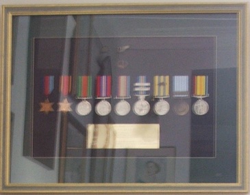 Tramways/East Melbourne RSL Sub Branch - RSL Victoria Listing id: 27511
Memorabilia - Replica Service Medals, In Memory of John Dalton Burke, Approximately 1998
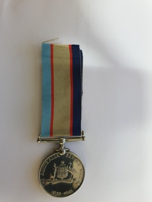
ContextualNine (9) Campaign Medals and Three (3) additional badges 1. 1939 - 45 Star 2. Burma Star 3. Defence Medal 4. War Medal 5. Australian Service Medal 6. Australian Active Service Medal 7. Korea Medal 8. United Nations Service Medal 9. Vietnam Medal 1. Leaf shaped badge attached to Korea Medal 2. Sword surrounded by leaves 3. Wing shaped cloth badge They are mounted in a frame.In Memory of John Murray Dalton Burke who served as 424506 POFF J.M. Burke RAAF 1942-1945 237656 Lt Col J.M. Burke RAR 1941-1974 Patron 1978-1988 & Hon. Life Member RAR Assn. (Vic Branch) "Lest We Forget"replica medals, korea medal, burma star, 1939-45 medal, defence medal, australian service medal, australian active service medal, united nations service medal korea, vietnam medal, royal australian regiment association, rar association -
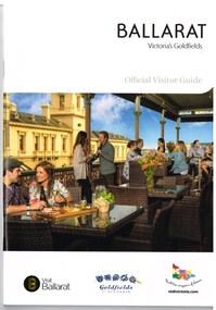 Ballarat Tramway Museum
Book, The Ballarat Visitor Information Centre, "Ballarat Victoria's goldfields Official Visitor Guide", 2015
Full colour, 84 page, book, A5 size titled "Ballarat Victoria's goldfields Official Visitor Guide", with a photo of a people eating on the verandah of the hotel opposite the old post office. Gives details, maps accommodation listing, attractions etc of the Ballarat area. Page 14 detail the Ballarat Tramway Museum. Inside rear cover is a fold out map of the district, city centre, Buninyong and Mt Helen and Ballarat and Surrounds. Published 2015 by The Ballarat Visitor Information Centre. trams, tramways, ballarat, visitors, tourist guides, btm, gardens -
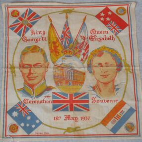 Bendigo Historical Society Inc.
Textile - Coronation souvenir handkerchief
King George VI was the second son of King George V and Queen Mary. He was Duke of York from 1920 to 1936, living in London and also (from 1932) at Royal Lodge, Windsor Great Park. In 1923 he married Lady Elizabeth Bowes Lyon; their elder daughter, later Queen Elizabeth II, was born in 1926. George VI succeeded to the throne on the abdication of his brother, King Edward VIII, in December 1936. Handkerchief produced as a souvenir for the Coronation of King George V1 and Queen Elizabeth on 12 May 1937. Images of the king and queen are set on either side of a circular view of Buckingham palace surrounded with representative flags and the Monarch's crown. Commonwealth (Empire) flags are placed at each corner. The British flag is below the image of the Palace. the flags are joined by a knotted circular gold coloured cord that traces the figures of the King and Queen. main colours are red, blue, white and gold on a cream background. handkerchief, coronation, 1937, king george vi -
 Clayton RSL Sub Branch
Medal, Australian Service Medal 1939-1945
YOUNG, John Alexander V82835 LieutenantAustralian Service Medal The medal features an effigy of King George VI on the obverse. The reverse has the Australian coat of arms, placed centrally, surrounded by the words "THE AUSTRALIAN SERVIE MEDAL 1939-1945". Ribbon The ribbon has a wide khaki central stripe, flanked by two narrow red stripes and edge stripes, one of dark blue and one of light blue. The khaki represents the Australian nature of the award and the red, dark blue and light blue represent the Army, Navy and Air ForceJ.A. Young V82835 -
 City of Greater Bendigo - Civic Collection
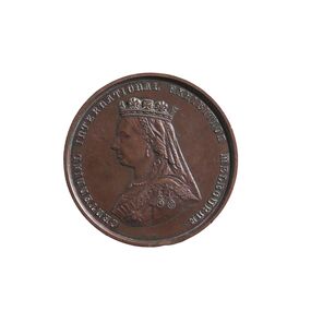
Medal - Centennial International Exhibition Melbourne 1888, Stokes and Martin, 1888
The 1888 Centennial International Exhibition, celebrating a century of Australian settlement, surpassed even the grand scale of the1880 Melbourne International Exhibition. It attracted over two million people, but the Victorian government had to spend £250 000 on it, ten times the amount estimated. The exhibition had a distinctively imperial focus, and a greater emphasis on culture than in 1880, particularly on music and painting (1). (1. https://collections.museumsvictoria.com.au/items/273830) S.D. Gadd was appointed Curator of Parks and Gardens in 1874 an lived in residence in Rosalind Park. He resigned in 1905 and moved to Melbourne where he died in 1917. Mr Gadd was a prominent member of the Masonic Lodge. It is not clear why he was awarded this medal.The bronze medal of the Centennial International Exhibition awarded to S.G. Gadd. Obverse - Portrait: bust of Queen Victoria in left profile wearing a crown, veil and 3 medals. Reverse - Field: Victor's wreath consisting of leaves and acorns of British oak and the leaves and acorns of the wattle. The oak and wattle were tied together 'by a true-lover's knot, 'symbolizing the unity and affection between the mother country and the colony'. Southern Cross inside surrounded by a legend. (https://collections.museumsvictoria.com.au/items/273822) Obverse - Motto: Centennial International Exhibition Melbourne Reverse - Legend: (Latin) Artibus Dignis Honor Insignis (To the deserving arts, distinguished honor) (Mint) left: Melbourne Mint. (Date) Lower Centre: MDCCCLXXXVIII. (Engraver) Right: Stokes & Martin S.C. Edge - Plain, impressed with S.G. Gadd ESQ.centennial international exhibition melbourne 1888, s.g. gadd, rosalind park, city of greater bendigo medals -
 Bacchus Marsh & District Historical Society
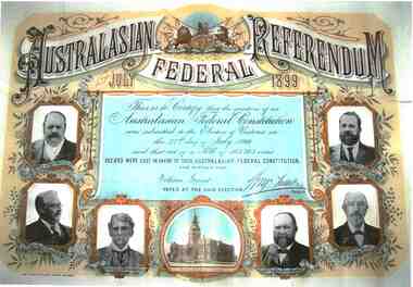
Certificate, Australasian Federal Referendum July 1899
William Grant Junior was President of the Shire of Bacchus Marsh in 1901 when the Australian Colonies federated to become a federal nation state. Grant was a member of a prominent local family and was active in public affairs throughout his life. The federation of the Australian Colonies was a turning point in Australian history and as such its achievement was celebrated in a range of ways. A major step towards achieving Federation was the referendum of July 1899 which saw five of the six Australian colonies vote in favor of Federation, with Western Australia later voting in favor in 1900.Printed poster sized document certifying that William Grant of Bacchus Marsh voted in a referendum of Victorian electors on 27th the July 1899 on the question of an Australian Federal Constitution. The body of the certificate text is surrounded on three sides by captioned photographic portraits of the Premiers of the six Australian Colonies. A British coat of arms is at the top of the certificate and at the bottom is an image of Parliament House in Melbourne, which includes a Dome, which was a projected feature of the building which was never actually added to the Victorian Parliament building.Across the top of the certificate: 'Australasian Federal Referendum July 1899'. In the centre: 'This is to certify that the question of an Australian Federal Constitution was submitted to the Electors of Victoria on the 27th day of July 1899 and that out of a Poll of 103,783 votes 152,653 were cast in favor of such Australasian Federal Constitution and further that William Grant, voted at the said election'. Signed, [George Turner], Premier. At bottom: 'Robt. S. Brian, Government Printer, Melbourne'.william grant 1850-1924, federation (1901), referendums, illuminated certificates -
 Mont De Lancey
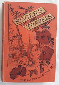
Book, E.Payson Hammond, M.A et al, Roger's Travels; or Scenes and Incidents with the Journey of two boys in foreign lands, and how they were led to start for the better country, 1886
The journey of two boys in overseas countries and their adventures with strong religious themes.Orange hardcover children's fiction book, Roger's Travels by E. Payson Hammond. M.A with the title surrounded by gold boxes and an illustration of a Dutch windmill and boat in the countryside. Brown flowers decorate the right side with the author's name E. Payson Hammond M.A underneath. The spine has the title author flowers and initials of the publisher SSU at the bottom. Black and white illustrations and full page plates are throughout. At the end are 15 pages of recommended books for young children by the Sunday School Union. 155p.fictionThe journey of two boys in overseas countries and their adventures with strong religious themes.religious fiction, adventure stories, children's books, morals fiction -
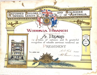 Wodonga & District Historical Society Inc
Certificate - Wodonga RSSILA Certificate of Appreciation, 1924
The Returned Sailors' and Soldiers' Imperial League of Australia was formed in 1916 to support servicemen returning from World War 1. In 1940 its name was changed to Returned Sailors', Soldiers' and Airmen's Imperial League of Australia and again in 1966 to Returned Services League of Australia. Arthur Ernest Beard enlisted in the 10th Battalion in 1914 and was discharged as medically unfit in 1918. His service included three years and 115 days of overseas service. He was gassed during his war service, resulting in ongoing health issues. Beard received an incapacity pension. Despite his ill health, Arthur dedicated many years of service to the committee of the Returned Sailors' and Soldiers' Imperial League of Australia Wodonga branch. At various times he served as President and secretary. He was on the committee when the branch was lobbying for the construction of a Soldiers' Memorial and also a Soldiers' Memorial Hall for Wodonga. Arthur also participated in groups and community activities, including the Wodonga Boys’ Club, Wodonga Public Library Committee and the Wodonga and District Progress Association. Arthur died on 29 Jun 1940 in Wodonga, Victoria, aged 46 years. This certificate is significant as it recognises service to the Wodonga Branch of the RSSILAA coloured certificate on heavy card presented by the Wodonga Branch of the Returned Sailor and Soldiers Imperial League of Australia. It features an archway imprinted with the name of the RSSIL with the League emblem surrounded by the flags of England, Australia and the Royal Australian Navy. It is adorned with an anchor and rifle and the words "Great War 1914 - 1919. An image of Anzac House, the headquarters of the R.S.S.I.L.A. in Melbourne is on the lower left hand side. The words of appreciation are printed in the centre of the archway. The insignia of the Australian Commonwealth Military Forces is in the centre at the bottom. WODONGA BRANCH / Presented to A. BEARD As a token of esteem and in grateful recognition of valuable services rendered as PRESIDENT Year 1922 - 23 A. A. Reid President R. S. Benson Secretaryreturned sailors & soldiers imperial league, wodonga rssila -
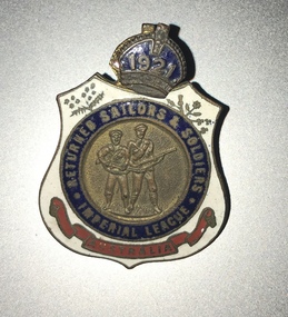 Melbourne Legacy
Badge, R.S.S.I.L.A. Member Badges
Two member badges from the The Returned Sailors, Soldiers Imperial League of Australia (RSSILA). The number 68 on the front could be 1968 as it is detachable and could be updated each year. The badge with 1921 could be the year of membership. The member number is engraved on the rear. The shield design is symbolic of the protection provided to those who wear it. Within the badge, red represents the blood ties of war that exist between comrades; white stands for the purity of the motives in joining the league – to render service without personal gain or ambition; and blue indicates a willingness to serve a comrade anywhere under the blue sky. The wattle represents Australia, with the leek, the rose, the thistle and the shamrock standing for Wales, England, Scotland and Ireland respectively. The RSSILA was the precursor to the Returned Services League (RSL) and provided support for returned servicemen after World War One. Worn by members of the Returned Sailors, Soldiers Imperial League of Australia, those eligible being members of all services, both wars, including nurses, who have returned from active service outside Australia. These were with other World War 1 memorabilia that has come from Private John Basil McLean, 2nd Reinforcements, 37th Battalion, A.I.F. J.B. McLean (Service No. 13824) was from near Maffra, Victoria and enlisted on 22 January 1916. He embarked on 16 December 1916 for Europe. He spent time with the Australian Field Artillery (Pack Section). At the end of the war he worked for a year at the A.I.F. Headquarters in London before returning to Australia on the 'Ceramic', arriving in Portsea in 1920. His full war record is available from the National Archives of Australia (B2455, MCLEAN JBM).The RSSILA was an important organisation for ex-servicemen and many Legatees would have been members.Enamel badges from the R.S.S.I.L.A. The centre of the badge shows a sailor and a soldier in raised detail. A blue enamel circle surrounds the central detail and has 'RETURNED SAILORS & SOLDIERS / IMPERIAL LEAGUE' in gilt lettering. The outer edges of the badge are white enamel with a floral spray to the top left and right of the blue circle. At the bottom of the badge is a red enamelled scroll with 'AUSTRALIA' written in gilt lettering. On the reverse of the badge are soldered two brass lugs with a split pin attached for securing the badge to clothing. 01124.1 Front has '68' and 'Returned Sailors and Soldiers Imperial League of Australia'. On the reverse 'V92210 Badge remains the property of League'. 01124.2 Front has '1921' and 'Returned Sailors and Soldiers Imperial League of Australia'. On the reverse 'R 3871' and 'C.C Roeszler and Son Pty Ltd Melb.'world war one, rssila -
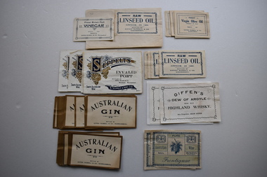 Warrnambool and District Historical Society Inc.
Ephemera - Labels, Gaspers Modern Print, Giffen Russell, Early 20th century
These labels come from the business of Giffen Russell and Company, a wine and spirits store in Fairy Street, Warrnambool. Giffen Russell commenced business in 1878 and was joined by Joseph Powell as a partner in 1881. The business of Giffen Russell and Co. was operating in the early 1900s and still went by that name in the 1940s with H.L.Lynch the proprietor at that time. These labels are of considerable interest as they show the extent of the goods sold by Giffen Russell, a prominent wine and spirits dealer in Warrnambool in the late 19th and early 20th centuries. .1 A sheet of white paper with a gilt edge and black printing .2 A sheet of white paper with a blue border and blue printing .3 A sheet of paper with blue printing and decoration on a green background .4 A sheet of white paper with a blue border and blue printing .5 A sheet of white paper with a decorative blue border and blue printing .6 A sheet of white paper pasted on to a piece of card. The printing is gold and blue surrounded by decorative patterns, including bunches of grapes .1Australian Gin bottled by Giffen Russell & Co. Warrnambool .2 Finest Virgin Olive Oil Product of Italy .3 Pure Australian Wine Frontignac bottled by Giffen Russell & Co. Warrnambool .4 Raw Linseed Oil bottled by Giffen Russell & Co, .5 Finest Brown Malt bottled by Giffen Russell & Co. Warrnambool .6 Seppelts Invalid Port bottled by Giffen Russell, Merchants, Warrnambool giffen russell, wine merchant, history of warrnambool -
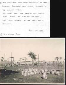 Bendigo Historical Society Inc.
Photograph - QC BINKS COLLECTION: INTERNMENT CAMP
5 copies of photos, all relating to internment camp near Tatura ? -between Rushworth and Tatura - Images shows rows of huts, inside fence line. Annotation by Q.C. Binks: a photo showing some of the huts of the No. 3 internment camp almost ready to receive the first of the German and Italian internees. Barbed wire fence and entanglement surrounded the camp The camp was in use during the 1939 - 45 war years. Very little remains today 2000. Photo April 1941.government, internment camp -
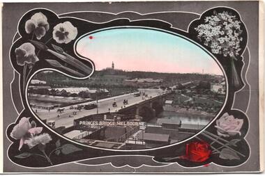 Melbourne Tram Museum
Postcard, SEMCO, "Princes Bridge Melbourne", mid 1900's?
Divided back postcard featuring a hand coloured black and white photograph of a view looking from Flinders St towards Government House, c1900, or from the roof of the Flinders St Station which could be under construction. Embossed Photograph enclosed within an artists palette, surrounded by roses. Note the buildings between the bridge and Government house - a former asylum? Card from the SEMCO Series Box 545 GPO Melbourne. Addressed to Miss V Hall of Blackwood.trams, tramways, princes bridge, cable trams, flinders st, flinders st station -
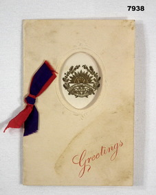 Bendigo Military Museum
Card - GREETING CARD - 6th BATTALION AIF, c.WW1
Card sent by "Pte Herbert Charles Nott", no. 228, 6th Batt, AIF. Part of the Cooper Collection.Four page card on cream coloured paper. Pages secured on LHS with blue and red ribbon. Front page has an oval cut out which reveals a gold coloured Rising Sun badge including the words 6th Battalion, surrounded by a wattle wreath. Cut out is edges with embossing. The word "Greetings" is printed in red on bottom RH Corner. The middle right page has text printed in blue type. Sender has written his name on this page.Handwritten in pencil on right hand middle page: "Bert".cooper collection, herbert charles nott, 6th battalion, card -
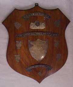 National Wool Museum
Award - The Industrial Choir Contest 1923 - Ald J C Kings Shield, 1923
Acquired when "Classweave Industries" closed down.Wooden shield with two silverplate etched bands inscribed "The Industrial Choir Contest 1923 and "Ald J C Kings Shield", between the ribbons is a metal plaque inscribed "Advance Geelong Industries", below that a silverplate shield- shaped plaque inscribed "Presented by Ald J C King JP, Mayor of Geelong, for Best Industrial Choir, to be won twice " , this is surrounded by four smaller lyre shaped plaques and another metal band etched "COMMUN NA FEINE 1856".The Industrial Choir Contest 1923 - Ald J C Kings Shield Presented by/ Ald J C King JP,/ Mayor of Geelong,/ for Best Industrial Choir,/ to be won twicetextile mills woollen mills textile mills - staff, classweave industries pty ltd federal woollen mills ltd, textile mills, woollen mills, textile mills - staff -
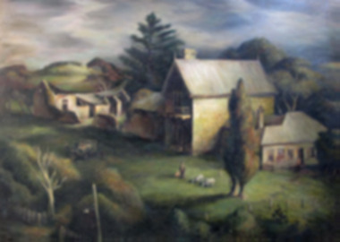 Glenelg Shire Council Cultural Collection
Painting - Oil Painting, Kenneth Jack, Captain Blair's House, n.d
Image showing three stone buildings in a country scene. In the foreground there is man and child and two goats. There is a car with three people surrounding it. The weather looks dark, dark clouds. A large Norfolk Pine behind the building. The middle building is two storey with an outhouse attached. A chimney and two spires at each end of the house. The building to the right of the main building is weatherboard with a fence. To the left of the main building is a ruined stone building with the roof fallen in. Trees and hills surround. Gold painted frame.Bottom right - Kenneth Jack - July 1952 -
 Glenelg Shire Council Cultural Collection
Painting, A.S. Murray, Scene on the River Glenelg, c. 1894
Art Collection Previously located in History HouseThe painting depicts a large body of water surrounded by hills. The body of water extends from the front right corner through to the centre of the work. Predominately depicted in shades of brown, the body of water has a white centre with three birds (swans) sitting on the surface. In the foreground to the left of the water is a riverbank with a large brown tree. The background consists of a large blue/grey hillside and brown cloudless sky. The work has a gilded ornate frame with a gold mount and exposed canvas.Front: A.S. Murray Back: W.HAMER, 189 Sturt Street, Ballarat, VICTORIA BUILDINGS, OPPOSITE CITY FIRE BRIGADElandscape, glenelg river -
 Bendigo Military Museum
Banner - BADGE COLLECTION MOUNTED, C.WW2
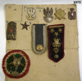
Items in the collection re Ian McLeod RWAFF, refer Cat No 2262.2 for service details.1 Badge silver inscription and crowned eagle. gold anchor and chain in centre. 2 Badge silver bottom half is a shield top half is a crowned eagle with wings outstretched. 3 Badge gold square on a gold square off set 45 degrees in centre is a lion the rear surrounds are two crossed swords. 4 Copper badge of an eagle with large crown there is an enamel white cross in centre of a red enamelled oval the birds claws are holding a lanyard. 5 Copper shield with cross rifles in it there is numbers 64 in red enamel circle in centre a crown is between. 6 Plain star 5 point 3 cm wide 7 grey cloth silver engine the bottom has British coat of arms. 10 cm x 5 cm. 8 Uniform. Black cloth rad binding has gold 3 pips, crown with red cross. crown gold thread. copper button. 9 Cloth rosette green centre white red surrounds 5 pointed brass star number 9 in centre surmounted with a crown.badges, collection, foreign -
 Marysville & District Historical Society
Photograph (Item) - Colour photograph, Unknown
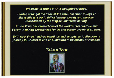
A colour photograph taken of a sign at then entrance to Bruno's Art & Sculptures Garden in Marysville in Victoria.A colour photograph taken of a sign at then entrance to Bruno's Art & Sculptures Garden in Marysville in Victoria. Bruno's Sculptures Garden is one of Marysville's popular attractions. There is a sculpture garden as well as a gallery of artworks. Both the garden and gallery were destroyed during the 2009 Black Saturday bushfires. Some of the sculptures were totally destroyed though a few did survive the fires. Bruno made the decision to re-sculpt the lost sculptures and re-built his gallery and re-open his garden to visitors to Marysville.Welcome to Bruno's Art & Sculpture Garden Hidden amongst the trees of the small Victorian village of/ Marysville is a world full of fantasy, beauty and humour./ Surrounded by the magical rainforest setting. Bruno Torfs has created one of the world's most unique and/ deeply inspiring experiences for art and garden lovers of all ages. With over three hundred paintings and sculptures to discover, a/ journey to Bruno's is one of Australia's most special attractions. Take a Tourbruno torfs, gardens-design, marysville, victoria, sculpture, australia, sculpture garden, sculptors, bruno's art and sculptures garden, 2009 black saturday bushfires, photograph -
![Scene in the Carlton Gardens / [by] Nicholas Caire, circa 1876](/media/collectors/550653872162f11fb04854aa/items/57825eedd0cdd1176ce4cdaf/item-media/57825f52d0cdd1176ce50427/item-fit-380x285.jpg) Kew Historical Society Inc
Kew Historical Society IncPhotograph, Anglo-Australasian Photographic Company, Scene in the Carlton Gardens, c. 1876
Nicholas Caire was born on Guernsey in the Channel Islands in 1837. He arrived in Adelaide with his parents in about 1860. In 1867, following photographic journeys in Gippsland, he opened a studio in Adelaide. From 1870 to 1876 he lived and worked in Talbot in Central Victoria. In 1876 he purchased T. F. Chuck's studios in the Royal Arcade Melbourne. In 1885, following the introduction of dry plate photography, he began a series of landscape series, which were commercially successful. As a photographer, he travelled extensively through Victoria, photographing places few of his contemporaries had previously seen. He died in 1918. Reference: Jack Cato, 'Caire, Nicholas John (1837–1918)', Australian Dictionary of Biography.An original, rare photograph from the series 'Views of Victoria: General Series' by the photographer, Nicholas Caire (1837-1918). The series of 60 photographs that comprise the series was issued c. 1876 and reinforced a neo-Romantic view of the Australian landscape to which a growing nationalist movement would respond. Nicholas Caire was active as a photographer in Australia from 1858 until his death in 1918. His vision of the Australian bush and pioneer life had a counterpart in the works of Henry Lawson and other nationalist poets, authors and painters.‘Scene in the Carlton Gardens’ : Views of Victoria (General Series) No.40 : Albumen silver photograph | Photo on card with Title and Description on reverse | Mounted 24 x 30 cm; Photo 12 x 17 cm.On Reverse: ‘The Carlton Gardens are not so extensive as most of the other public gardens around Melbourne, and, being laid out on a flat piece of ground, have not the advantage of possessing much that is romantic in its scenery. The subject of this issue is the only interesting spot within the enclosure, which is the Rustic Fountain, surrounded by a small lake of water, on the banks of which grow some very beautiful specimens of the hanging willow. These Gardens are open to the public at all times.’nicholas caire (1837-1918), carton gardens, exhibition building, landscape photography - victoria -
 The Beechworth Burke Museum
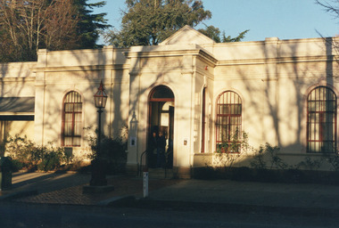
Photograph, Unknown
This undated photograph depicts two people standing in the vestibule entrance at the Burke Museum, Beechworth. The museum site dates to the 1857 founding of the Beechworth Public Library and Athenaeum by a newly formed Young Men's Association (YMA). In 1863 the museum was dedicated as a memorial to former Beechworth police superintendent (1854-1858) and explorer Robert O’Hara Burke, following Burke’s death from malnutrition on the Burke and Wills expedition in 1861. Funded by the Victorian Government and the Royal Society of Victoria, the officially titled 'Victorian Exploring Expedition' was tasked with being the first European party to traverse Australia from south to north. The Burke Museum holds objects from the famous expedition and explores the multi-layered history of Beechworth and surrounds from the gold rush era to the present.This photograph is historically significant for its depiction of the Burke Museum and Loch Street streetscape. The Burke Museum is Australia’s oldest regional museum and part of Beechworth's Historic and Cultural Precinct, one of Australia’s best preserved historic-town sites and a popular tourist destination. Once the government centre for a vast gold fields region, this collection of nationally significant buildings tells the story of how Australia grew and prospered. The frequent use of honey-coloured local granite as a building material, which can be seen in the museum's fabric, gives Beechworth’s historic buildings a distinct and cohesive local character. This photograph may be compared and studied alongside other images of historic buildings in the Burke Museum Photographic Collection.Rectangular colour photograph printed on photographic paper.Reverse: 3440burke museum, beechworth athenaeum, beechworth library, beechworth historic precinct, robert o'hara burke, australia's oldest regional museum, indigo shire, beechworth athanaeum, beechworth historic building, historic precinct, honey-coloured local granite, victorian gold fields, historic towns in victoria, victoria's high country, colonial australia, beechworth tourism, things to see in beechworth, beechworth historic trail, historic victorian architecture, burke and wills expedition, first europeans to cross australia, young men's associations