Showing 11319 items matching "land-clearing"
-
 Bendigo Historical Society Inc.
Archive - LAND SALES
DVD. Land Sales taken from M Drive and Gleny's Computer Two discs. -
 Ringwood and District Historical Society
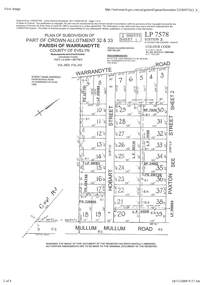
Document - Subdivision Plan, Part of Crown Allotment 32 & 33 Parish of Warrandyte, County of Evelyn Vol 3922 Fol 242
LANDATA Land Victoria 2-sheet plan printout dated 16/6/1919.Sheet 1 includes Warrandyte Road, Hobart Street, Paxton Street, and Mullum Mullum Road, Ringwood, Vic. Additional markings include PS327701, LP215189, RP7936, LP110103, LP36735, LP31149, SP24012, PS310739, PS326740, PS336885, LP41558. Sheet 2 includes Warrandyte Road, Paxton Street, Arnold Street, and Mullum Mullum Road, Ringwood, Vic. Additional markings include RO270, SP26622, LP50242, RP19467, SP27005, SP31440, PS312181. -
 Chelsea & District Historical Society Inc
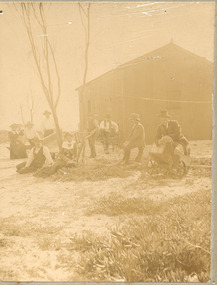
Photograph - Morton Family, After the 1913 fires in Chelsea, c 1913
Mr Alfred Morton with his sisters, brothers and friends camping at Carrum in the 1890's. This area was later called Chelsea. Alfred Louis Morton (known as Louis) was born in Geelong in 1866, the fifth of eleven children of Mark Morton and Eliza nee Heard (married 1898). Alfred began work for the Post Office at South Yarra in the 1890s. In the late 1800s it was common for people from Melbourne and north of the city to travel to Chelsea area beaches for their holidays and many liked the area so much that, like the Mortons, they moved here permanently. In the 1890s Alfred’s sister, Mrs William Ashmore, built a weekend house at the foot of what is now Foy Avenue in Chelsea. The Morton family, including Alfred, visited the area often, camping on the foreshore during the 1890s. In 1911 Alfred moved his family permanently to a house on the corner of Morton Grove and Main Road Chelsea (now known as the Nepean Highway) on property that extended from the main road to the beach. This house was destroyed in the fire of 22 December 1913 which raged amongst the ti-tree on the foreshore between Aspendale and Chelsea. Many buildings were destroyed in this fire. The Argus newspaper reported on Wednesday 24 December that 94 houses were burnt with glowing embers blown a mile and half inland. According to the Argus but for the wide break provided by the Point Nepean Road (now the Nepean Highway) and the railway line, the scrub on the other side might have caught. The Morton children, Elsa and Ivan, attended Chelsea State School (now Chelsea Primary School) and Mrs Morton was active in the establishment of St Chad’s Church of England in Chelsea. At the age of 80 in 1945 Mr Morton was concerned about reports that English children had lost their toys due to the war and so he made (as part of a wider effort in Australia) 100 toy engines that were sent to England. He died in 1946 in Chelsea.Sepia photo of members of the Morton family sitting on their land after the fires in Chelsea, 1913.morton, chelsea, carrum, verandah, fires -
 Bendigo Historical Society Inc.
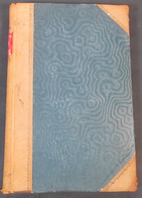
Legal record - Ledger of Reports of Land Sales by Auction
Blue and light brown ledger of land sales reports during 1898 to 1924. Blue water marked cover with light brown spine and corners, with red label on spine noting "12". Contains Crown Lands sales by auction documents, including purchasers' names, land section, allotment numbers and price. Ledger of Land Sales Reports 1915 sample reports of Colbinabbin, Kyabram & Rochester.land sales, auction -
 Tatura Irrigation & Wartime Camps Museum
Sewing Machine, 1930's
Machine owned previously by Mrs Clare French. Bough by Mrs Bev McMahon at Stephen as Both's clearing sale 1975 (son-in-law). -
 Bendigo Historical Society Inc.
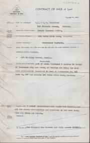
Document - H. A. & S. R. WILKINSON COLLECTION: CONTRACT OF SALE
Contract of sale of land dated 25th February, 1955 between Mr. E. C. Spence (vendor) and Mr. E. K. Pipkorn (purchaser). Property: land being part of Crown allotment 8 section 19 Parish of Sandhurst, City of Bendigo being land described in deed of conveyance No. 11 book No. 567 and situate 306 White Hills Road, Bendigo, together with 5 roomed weatherboard and rough cast dwelling and all sundry buildings on said land. Also all linos and blinds. Price: 2,250 pounds.organization, business, h.a. & s.r wilkinson real estate -
 Beechworth Honey Archive
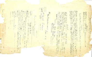
Hand-Written Copy of Particulars and Conditions of Sale of Land May 1922
This item consists of two pages. Page One: Hand-written copy of a Particulars and Conditions of Sale of Land for a piece of land in Moira county (East of Goulburn River, South of Murray River, West of Ovens River). Also inculded is a hand-written copy of a Particulars and Conditions of a Contract of Sale; Frank L. Frost is selling land to Bridget Ellen Ryan. Takes place in May 1922. Copy of Transfer of Land Title. Purchase price £478.11.3 Page Two: A list of Parish, Shire and County locations. Both pages written with black ink on paper. hand written, hand-written, particulars, conditions, sale, land, title, parish, shire, county, ryan, frost, beekeeper, beechworth honey -
 Whitehorse Historical Society Inc.
Document, Canterbury Road Tunstall, 29/01/19?5
Photocopy of letter to the Commercial Bank, Prahran re land and property valuation occupied by Mr Sliegner, north side of Canterbury Road, Tunstall (Now Forest Hill) close to Springvale Road. Land 2.5 acres with villa and out buildings.land values, sliegner (mr), canterbury road, forest hill, c. husband (estate agent) -
 City of Whittlesea
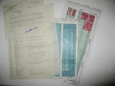
Document - Correspondence, Station Entrance and Railway Platform Estate, 1937
Letter from Ellison, Hewison & O'Collins Solicitors, Melbourne to the Shire of Whittlesea in reponse to a request for the names and addresses of the purchasers of blocks of land on the Station Entrance Estate and Railway Platform Estate, Thomastown. Both estates where originally subdived and sold in the mid 1920s. The collection includes a letter, a list of owners and their address details and the lot they own, and plans of both estates, which have been cut out of the original estate sale posters. Streets include High Street (Epping Road), Mount View Road, Pleasant Road, Central Avenue, Highlands Road and Main Street, ThomastownLetter, paper 3 pages, 2 plans. Letter from Ellison, Hewison & O'Collins Solicitors, Melbourne to the Shire of Whittlesea in reponse to a request for the names and addresses of the purchasers of blocks of land on the Station Entrance Estate and Railway Platform Estate, Thomastown. -
 Flagstaff Hill Maritime Museum and Village
Map - Survey Map, F.F. McGovern, Yangery - County of Villiers, 1884
A surveyor was employed to measure the land designated as Yangery, County of Villiers, in the Borough of Warrnambool. The area on the map is similar to the earlier Farnham Survey undertaken by William Rutledge in the 1850's. Warrnambool was a Borough between 1863-1883. Coutours, waterways, sea and other significant points are shown. The distances are accurately measured. This survey map was used for planning future land sales, recreation areas and roads. WILLIAM RUTLEDGE (1806-1876) William Rutledge surveyed the land known as Farnham in southwest Victoria in 1843. His tenants made him a profitable business from working the land there. In 1863 Rutledge moved from nearby Port Fairy to Farnham and became very successful in breeding sheep, which he imported from J.R. Kirkham of Lincolnshire, England. He also bred horses on his land. The survey map of Yangery is important for its connection with renowned surveyor William Rutledge. The map shows the growth of landholders in the district when compared to the original Rutledge survey of the 1850's.Survey map of Yangery, titled "Yangery - County of Villiers". Printed on white paper, mounted on brown paper. c. 1863-1876. Comments printed on the Map include; Special Survey by William Rutledge, Photo-lithographed at the Department of Lands and Survey, Melbourne by W.J. Burson, Price 1/- [one shilling]. Scale is in Chains. Map has boundaries of Koroit Borough, Meerai, Purnim, Wangoom, Borough of Warrnambool, Mentions the Proposal of Tower HIll for Public Recreation. The map names the owners of the land at that time. Hand written pencil marks and figures and "Sauls fence" drawn on map. Hand written pencil markes and figures and "Sauls fence" drawn onto map. "For Department Use only". "Scale: 8 chains to 1 inch" flagstaff hill, warrnambool, shipwrecked-coast, flagstaff-hill, flagstaff-hill-maritime-museum, maritime-museum, shipwreck-coast, flagstaff-hill-maritime-village, county of villiers map, yangery district, w.j. burson, borough of warrnambool, koroit, purnim, meerai, wangoom, proposal of tower hill for public recreation, special survey by william rutledge, william rutledge, farnham, lincolnshire sheep, clydesdale -
 Kiewa Valley Historical Society
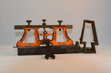
Sharpener Saw Raker/Jointer, early 1900s
This raker/jointer/guage set is a sharpening tool for cross cut logging saws. The logging saws used in the early 1900's for the clearing of forests required constant sharpening of their "cutting teeth". The logging of forested areas during these times was very much a "hands on" method of either one or two men by the use of saw or hand axe. Chain saws, chain and ball(clearing) and bulldozing methods came in the mid 1900's.This particular saw sharpening method was used by surveyors laying down boundaries for the S.E.C. Victoria Hydro Electricity Scheme (1920's). This item was given to a local Kiewa Valley lad who accompanied the initial surveyors. The lad was responsible for the tendering and feeding of the surveyors "pack horses". Surveys during this period and in the dense mountainous terrain of the Victorian Alps was both exhausting and hazardous. Overnight accommodation at various log cabins was not always possible and swag/tent alternative was the "fall back" This raker/jointer saw sharpener was made in the USA (DISSTON) from cast and flat iron. The main body has been painted in orange. It has three adjustment screws on the top horizontal bar and one bolt on(adjusting) leveling platform on the bottom. The small size and weight of this saw sharpener was ideal for the travelling/mobile logger or surveyor(as in this case). The main frame resembles two towers connected by two horizontal bars and the top of the towers has a horizontal bar with adjustment screws. See KVHS 0090 (B) for setting stake wedge adjusting the rake and cutting angle and KVHS 0090 (C) for a small spanner (for adjustments).On one inner supports is stamped "DISSTON" and on the other "U.S.A."hand tool, saw, sharpening method, tree felling. -
 Halls Gap & Grampians Historical Society
Photograph - B/W, C 1919-1920
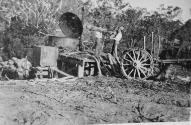
Burning charcoal for the Ararat Gas Company. The location is unknown.The photo shows two men standing on a platform feeding wood into a large charcoal burner.To the right there is a wagon (from which they are getting the wood) with a horse hitched to it (only the rear part of the horse is visible). To the left are full sacks. There is bush in the background and a rutted clearing in the foreground.timber industries, charcoal burning -
 National Vietnam Veterans Museum (NVVM)
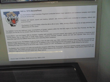
Poster - Poster, Information Board, 5 RAR 1969 - 1970 (Second Tour)
An informatation board of the 5th Battalion Royal Australian Regiment conducted sixteen major operation and numerous company sized sweep during its second tour. Cordons and search, search and destroy, ambush, and clearing patrols were conducted at company, platoon and sectional levels.poster, information board, 5 rar, battle of binh ba, battle honour, 1 atf, nui thai vai mountains, phuoc tuy province, viet cong, 33 nva regiment, guerrilla warfare, may tao mountains, hat dich, capt d s wilkins -
University of Melbourne, Burnley Campus Archives
Newspaper - Newspaper Cutting, The Age, The News of the Day, 1861
Photocopy of article in "The Age" 6 June, 1861 p5. Description of the Monthly Meeting of the Committee of the Horticultural Society of Victoria. Progress on fencing and clearing of 11 acres, cottage built for foreman. Dr Mueller had given a very valuable collection of trees, plants and shrubs.the age, rhsv, royal horticultural society of victoria, von mueller, donation of plants, fencing, establishment of experimental gardens, burnley gardens, cottage, foreman, curator, monthly meeting -
 Eltham District Historical Society Inc
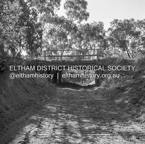
Negative - Photograph, J.A. McDonald, Heidelberg-Kinglake Road, Mar. 1960
Cherry Tree Road Job 56F443 Contractors Wolf and Wood Old bridge and stream clearing during construction of new bridge March 1960Record of various Shire of Eltham infrastructure works undertaken during the period of 1952-1962 involving bridge and road reconstruction projects, sometimes with Eltham Shire Council Project Reference numbers quoted. It was during this period that a number of significant improvements were made to roads and new bridges constructed within the shire that remain in place as of present day (2022). In many situations, the photos provide a tangible visible record of infrastructure that existed throughout the early days of the Shire. The album was put together by or under the direction of the Shire Engineer, J.A. McDonald.infrastructure, 1960-03, bridge construction, cherry tree road, heidelberg-kinglake road, road construction, shire of eltham -
Glenelg Shire Council Cultural Collection
Weapon - Whaling Harpoons, n.d
Original owner - one of the Henty brothers, bought by Margaret's grandfather, Matthew Edward Mabbitt, lighthouse keeper at a Henty clearing sale about 1900Two matching harpoons with wooden handles. Metal harpoon heads have been re-plated at some stageBack: 'Mcmillan' on back of both harpoon heads - first two letters unclearwhaling, maritime industry, hunting, henty -
Clunes Museum
Document - CERTIFICATE OF TITLE
.1.2 CERTIFICATE (TRANSFER) OF LAND TITLE VOL 282 FOL 56288 15/10/1868 .3.4 CERTIFICATE (TRANSFER) OF LAND TITLE VOL 699 FOL 139606 23/7/1874 .5.6 CERTIFICATE (TRANSFER) OF LAND TITLE V.164 F32657 2/3/1866 .7.8 CAVEAT 21615 BROUGHT BY NASE, HEWILL, MULLER 16/5/1890 .9 CAVEAT BROUGHT BY MULQUINNEY 16/5/1890 .10.11 OBJECTION TO SIGN CAVEAT TS BARRY (2 COPIES) .12.13.14.15.16 SUPPORTING RESEARCH DOCUMENTS INCLUDING A SPREADSHEET WHICH OUTLINES THE GIFT OF JOSHUA GREEN COWAN'S OF LAND FOR CHURCH PURPOSES. THESE DOCUMENTS PROVIDE DETAILS OF FAMILY HOLDINGS IN THE AREA OF ASCENDANTS OF THE LAND OWNERS. jg cowan, ullina hall, title of certificate -
 Ringwood and District Historical Society
Map - Plans of Subdivision, Part of Crown Allotments 35 & 39, Parish of Warrandyte
Survey maps of stages 1, 2 & 3 of residential allotments in Kalinda Road and Grayling Crescent, Ringwood, Victoria. (Undated, circa 1960). Some allotments are marked with real estate information and prices in pre decimal £s.Adshead & McGuire, Land Surveyors L.S. M.I.S. (Aust), 268 Albert Street East Melbourne (Ref 118/2a b &c) Tel 41-6960. The land colored blue is set apart for drainage & sewerage purposes. Reference Marks (R.M's) are Gal Iron Pipes 12"x1". Levels shown are to M.M.B.W. Datum. The land shown hatched is subject to innundation. -
 Ballarat Heritage Services
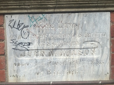
Photograph - Photograph - Colour, Clare Gervasoni, YMCA Ballalrat, 2016, 30/07/2016
At one time pre-service teachers' of the Ballarat Teachers' College boarded at the YMCA. There also used to be an inside pool at the site. Three photographs relating to the YMCA Ballarat building, including the Foundation stone. The land on which this building is erected was given by John W. Wilson one of the pioneer citizens of Ballaratymca, young mens christian association, foundation stone, camp street, ballarat, john w. wilson -
 Ballarat RSL Sub-Branch Inc.
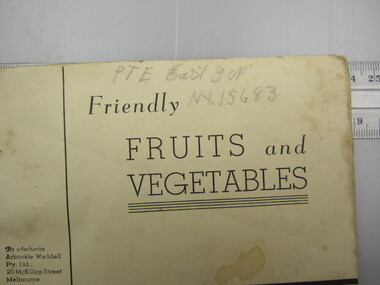
Book - "Friendly Fruits & Vegetables"
This object relates to Ivan Norman EAST. He was born on 24/03/1916 in Ningan, NSW. Ivan Norman served in the Army (V15683) enlisting on, 05/06/1941 in Ballarat, VIC before being discharged from duties with the 3 ADVANCE ORDNANCE DEPOT as a Army Non-Commissioned Private (PTE) on 16/06/1948. Ivan Norman EAST was not a prisoner of war.Prepared by the General Staff, LHQ, Australia and under the authority of the Commander Allied Land Forces SWPAsecond world war (ww2), 1939 - 1945, literature, ballarat rsl, ballarat -
 Kew Historical Society Inc
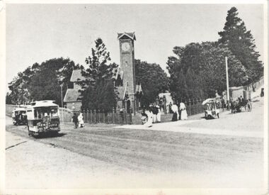
Photograph, Entrance to Boroondara General Cemetery, c.1900
This work forms part of the collection assembled by the historian Dorothy Rogers, that was donated to the Kew Historical Society by her son John Rogers in 2015. The manuscripts, photographs, maps, and documents were sourced by her from both family and local collections or produced as references for her print publications. Many were directly used by Rogers in writing ‘Lovely Old Homes of Kew’ (1961) and 'A History of Kew' (1973), or the numerous articles on local history that she produced for suburban newspapers. Most of the photographs in the collection include detailed annotations in her hand. The Rogers Collection provides a comprehensive insight into the working habits of a historian in the 1960s and 1970s. Together it forms the largest privately-donated collection within the archives of the Kew Historical SocietyThe entrance to Kew cemetery showing the clock tower and horse trams in High Street. The horse tram was at this time the only public transport by which visitors could reach the cemetery. The photograph postdates the construction of the surrounding brick fence which was constructed in 1895-96. "Views Boroondara Cemetery. Land set aside 1859. Photo after brick wall was built."boroondara general cemetery, dorothy rogers -
 Phillip Island and District Historical Society Inc.
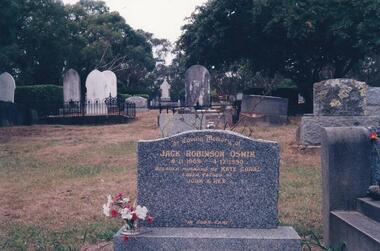
Photograph Album, Kodak, Phillip Island Cemetery, c 1990
The Album was compiled by Nancy McHaffie late 1990's, with the assistance of Edith Jeffery's, with her book "Garden of Memories" and extensive knowledge of Phillip Island. The Cemetery lies back from the road and is surrounded by Manna Gums, rare Peppermint Gums, Blackwoods and other native trees. In all 25 acres of land were set aside as Crown Land in the land settlement of 1868. There are 6.2 acres of wetlands near the cemetery entrance.Jack Robinson Oswin: Many of the trees now flourishing in the cemetery grounds were planted by Jack Oswin and his wife Coral. Born in Mildura in 1909, his association with Phillip Island started when he attended the Cowes Primary School during the war years. He was foundation member of the Phillip Island Conservation Society and played a key role in the purchases of the area of land known as Conservation Hill. In the early 1980s he was awarded the British Empire Medal in recognition for his services to conservation. Jack died on December 4th 1990, aged 81 years.phillip island cemetery, jack robinson oswin, coral oswin, nancy mchaffie, edith jeffery -
Whitehorse Historical Society Inc.
Document, Jones Family History
Brief history of the Jones FamilyBrief history of the Jones Family from emigration of James Jones in 1852 to 1970 with papers relating to purchase and fencing of land, part of Crown Allotment 116G, Lot 2, for building of Nunawading South Primary School No 4808, including a native flora area, c 1957. Also papers from the Native Plants Preservation Society of Victoria.Brief history of the Jones Family jones, james, jones family, bette, walter edgar, lionel arthur, kones, k.e. & l.a., native plants preservation society of victoria, nunawading south primary school, no. 4808, mount pleasant road, nunawading, florists, lorikeet street, dagola court, koala avenue -
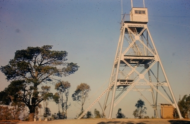 Bendigo Historical Society Inc.
Slide - Peter Ellis Collection, Kaweka Wildflower Reserve, Castlemaine, Lightning Hill Lookout Bendigo, One Tree Hill Lookout Tower Bendigo, Kamarooka Forest Area, c1970-1972
Kaweka Reserve is a a small reserve of approximately 8ha. The land was donated to the Castlemaine City to be a wildflower Reserve. A management committee was formed in 1966. The committee is still managing the park. Vicroads Edition 6: Map 59E2, 628 H4 Location. Turner St, Castlemaine. From the Castlemaine Post Office, drive north (towards Bendigo) and turn right along Turner Street to the park entrance. What to do: walk along some of the tracks through the park follow the nature trail bird watch have a picnic at the picnic tables. RUSH Dam is a basic free camping area sits alongside Rush Dam in the Greater Bendigo National Park, featuring a single picnic table and wood fire barbecue.Peter Ellis Collection: Seventeen slides of Kaweka Wildflower Reserve, Castlemaine, Lightning Hill Lookout Bendigo, One Tree Hill Lookout Tower Bendigo. Also the Rush Dam free camping area at Kamarooka. Also a slide of an unknown group having a meal or day out; perhaps also a working bee. In addition there are two slides of a house - location not specified; and a working bee clearing along a pipeline at Big Hill. Peter was a chemistry lecturer at the Bendigo Institute of technology.history, bendigo, peter ellis collection, whipstick bendigo, bendigo state forests, kaweka wildflower reserve castlemaine, one tree hill lookout bendigo, lightning hill lookout bendigo, kamarooka, rush dam kamarooka, greater bendigo national park -
 Flagstaff Hill Maritime Museum and Village
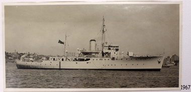
Photograph - Vessel, Steam Ship, H.M.A.S. Warrnambool J202, 1941-1947
This photograph is connected to the first HMAS Warrnambool J202, which was commissioned by the Royal Australian Navy for use as a minesweeper during World War II. The Bathurst Class Corvette, fitted out with a range of armaments, was launched in Sydney 1941. The ship began service in Bass Strait in 1941. At the end of the year it called into its namesake city, Warrnambool, where the crew paraded for the public marching eastwards along Timor Street. A gift of books for the ship’s personnel and a plaque bearing the City of Warrnambool’s Coat of Arms were presented to the ship. The ship was involved in evacuating a family of nine from the Dutch East Indies that was later successful in its challenge of Australia’s Immigration Restriction Act (White Australia Polity). The ship had many other appointments around Australia. On 13th September 1947 HMAS Warrnambool was leading a flotilla of minesweepers in northern Queensland’s coastal waters, clearing mines previously laid to defend Australia. The ship hit a mine, which exploded and very quickly sunk the ship. Boats from the nearby ships rescued most of the seamen although one was killed at the time. The survivors were taken by the HMAS Swan II to Darwin, and they went from there to hospitals in Brisbane and Sydney. Three of these men later died from their injuries. A number of items were recovered by Navy divers in 1948 including the ship’s bell and a plaque with Warrnambool’s Coat of Arms. In 1972-75 the wreck was sold and other items were salvaged. In 1995 a memorial plaque was erected in Warrnambool near the RSL. NOTE: The RAN built a second HMAS Warrnambool FCPB204, launched in 1981 and decommissioned in 2005. There was also a steam ship SS Warrnambool built in London 1892 and broken up in 1926. [A more detailed history can be found in our Collection Record 3477.] This photograph is significant for its association with Royal Australian Navy and its vessel, HMAS Warrnambool (j202). The HMAS Warrnambool played a nationally significant role in overturning Australia’s Immigration Restriction Act 1901 (colloquially known as the White Australia policy). The ship rescued, and brought to Australia, Samuel and Annie Jacob and their family after they evacuated Dutch East India. The family was threatened with deportation and made the first successful appeal to High Court regarding that Act. The HMAS Warrnambool has - Local significance for being the namesake of the City of Warrnambool - Local significance, having docked in Warrnambool Harbour - Local significance, the crew having paraded in Timor Street, Warrnambool - State significance for its first patrol being in Bass Strait. - National significance, being present in Timor at the Japanese surrender - National significance as part of Australia’s defence force history, being one of only four Bathurst class corvettes lost while in Australian service, the only Bathurst class corvette lost after World War II, the only RAN vessel to be sunk by a mine, and associated with the last four Navy deaths of WWIIPhotograph, black and white, HMAS Warrnambool J202 in water with land and buildings in background. Ship is flying a dark flag with Union Jack in corner and star below it. Lifeboat suspended above deck in centre of ship. Top of funnel has a black band. flagstaff hill, warrnambool, shipwrecked-coast, flagstaff-hill, flagstaff-hill-maritime-museum, maritime-museum, shipwreck-coast, flagstaff-hill-maritime-village, maritime village, maritime museum, shipwreck coast, mort's dock & engineering co ltd, h.m.a.s. warrnambool, hmas warrnambool, hmas warrnambool i, hmas warrnambool j202, hmas swan ii, j202, world war ii, bathurst class corvette, royal australian navy, ran, sydney built ship, bass strait patrol, sea mine patrol, mine sweeper, mine clearance, navy divers, great barrier reef, cockburn reef, southern cross diving and salvage, warrnambool city council, cr j r astbury, mayor j r astbury, warrnambool patriotic fund, seal, coat of arms, ship’s bell, hmas warrnambool 1941, shipwreck by sea mine 1947, sinking ship, sunk ship, sea rescue, life saving, lifesaving, minesweeper -
 Bendigo Military Museum
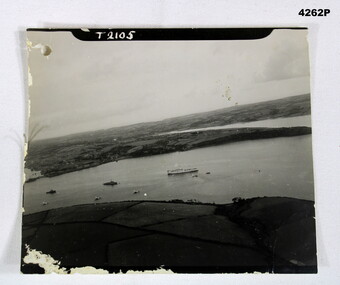
Photograph - AERIAL PHOTO, Possibly 1944
Photo in the collection of Reginald Charles Allardice No 418557 RAAF. Refer Cat No 3627.5 for his service details.B & W photo showing land and sea with one large ship and several smaller ones.On front, “T2105”. On rear in pencil,” Hospital ship Dorsetshire P.D 1 od.44 A/Z01”, stamped on rear “Crown copyright reserved”, above this as part of the stamp “A crown image M”photography, hospital ships -
 Bendigo Military Museum
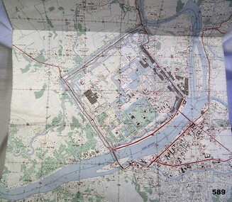
Map - MAP HUE VIETNAM, C.1960’s
The city of Hue is in South Vietnam. The map was used by a member of the AATTV during the Tet Offensive in Thau Thien province. Map brought home from Vietnam by Murray Stanley Metherall. Refer 590.2.Colour printed map of Hue Citadel on paper. Aerial view of land, river and building outlines.hue, vietnam, tet -
Federation University Historical Collection
Photograph, Opening of the Alcoa Laboratory, 1995, 08/12/1995
Four photographs from the opening of the Alcoa Laboratory for Soil and Land Management on the Mount Helen Campusalcoa laboratory, martin westbrooke, geoffrey colemen, john hannagan, alcoa laboratory for soil and land management -
 Phillip Island and District Historical Society Inc.
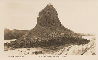
Photograph - Post Card, Early 1900's
Donated by G. HaywoodBlack & White Postcard of Pyramid Rock with two figures standing on top. Land mass in background."The Rose Series, P. 663" "The Pyramid, Cowes, Phillip Is., Victoria"pyramid rock phillip island, phillip island, g haywood -
 Montmorency–Eltham RSL Sub Branch
Artwork, other - Diorama, Cambodia, 2007
Chris Albers served in Cambodia, with the UN Forces late 90's Glass case rectangle, Land Rover UN markings, Figurines UN Military, plastic foliage.UN cambodia, un forces,