Showing 2126 items
matching map of bendigo
-
 Bendigo Historical Society Inc.
Map - PANNOOBAMAWM, 7/12/1914
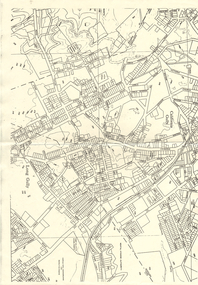
... Inc. History House 11 Mackenzie Street Bendigo goldfields MAP ...Map: Parish of Pannoobamawm, County of Bendigo. Parish plan (number 313 in map cupboard 1)map, bendigo, parish plan, pannoobamawm -
Bendigo Historical Society Inc.
Map - SEDGWICK, 5/04/1881
... Inc. History House 11 Mackenzie Street Bendigo goldfields MAP ...Map: Parish of Sedgwick, County of Bendigo. Parish plan (number 312 in map cupboard 1)map, bendigo, parish plan, sedgwick -
 Bendigo Historical Society Inc.
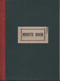
Document - MCCOLL, RANKIN AND STANISTREET COLLECTION: FORBES CARSHALTON GMC N/L - MINUTE BOOK, 1939 - 1947
Document. Minute book. Dark green cover with red binding. Label minute book white black lettering Dated October 1939 - August 1947. Written and typed letters (receipts) in rear. Map of Forbes Carshalton shaft inside cover.McColl, Rankin & Stanistreetorganization, business, forbes carshalton gmc n/ll, mccoll, rankin & stanistreet, forbes carshalton gmc n/l, gold mining, minutes -
Bendigo Historical Society Inc.
Archive - MCCOLL, RANKIN AND STANISTREET COLLECTION: BLUE MINING BOX - NEW DON MINE
... MINING Parish Map new don mining Bendigo gold gold mining McColl ...Object: blue metal mining box. 'New Don' printed on front of box in white paint. Box contains documents relating to New Don mine. Tag affixed to front of box, (formerly ) box number 475.mining, parish map, new don, mining, bendigo, gold, gold mining, mccoll, rankin & stanistreet, new don -
 Bendigo Historical Society Inc.
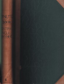
Document - MCCOLL, RANKIN AND STANISTREET COLLECTION: CENTRAL NELL GWYNNE GMC N L - MINUTE BOOK, 1946 - 1955
Document. Leather bound (tan) green cardboard cover. Hand written minute book. Dated 20/12/1946 - 24/6/1955. 2 hand drawn maps of mine on drafting paper. Letters re sale of buildings, battery & equipment for cost of 7500 pound. Complete description of battery.McColl, Rankin & Stanistreetorganization, business, central nell gwynne, mccoll, rankin & stanistreet, central nell gwynne gmc n l, gold mining, minute book -
 Bendigo Historical Society Inc.
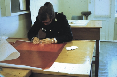
Slide - AHQ,SURVEY REGT, FORTUNA,BENDIGO, April 1970
Slide. AHQ, Survey Regt, Fortuna, Bendigo. A Survey member inspecting a map.slide, bendigo, ahq, survey regt, fortuna, bendigo., ahq, survey regt, fortuna, bendigo. -
 Bendigo Historical Society Inc.
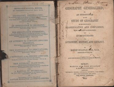
Book - HARRIS COLLECTION: GEOGRAPHY GENERALIZED
Book, 382 pages, brown board cover: ' Geography Generalized or an Introduction to the Study of Geography on the principles of classification and comparison with many illustrations through maps and illustrations' On front page in black pen ' Jonathan William Harris 1886' and ' Australia' written twice in same. Over page 'Jonathan W. Harris, his uncle. A gift from P.J. Murphy, 34 Little Oxford St., Collingwood. Jonathan W. Harris, August 26th, 1873' Published by Marcus and John Sullivan, 27 Marlborough Street, London. 1864Robert Sullivan, Barrister at Law.person, individual, jonathan harris, axedale -
 Bendigo Historical Society Inc.
Map - LONG GULLY HISTORY GROUP COLLECTION: MAP OF LONG GULLY AREA
... Bendigo Historical Society Inc. Bendigo Historical Society ...map of Long Gjully and California Gully area from Craig Street to Barrell Street. Indicators show location of the mental hygiene Austhority, Agricultural Showgrounds and Recreation Reserve. The boundary between the Borough of Eaglehawk and Bendigo is shown by a dotted line along McGowan Street.eaglehawk, history, street map long gully/california gully. -
 Bendigo Historical Society Inc.
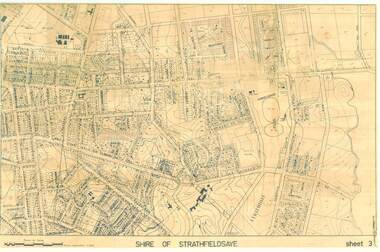
Map - SHIRE OF STRATHFIELDSAYE SHEET 3 PLAN OF PROPERTIES
... Inc. History House 11 Mackenzie Street Bendigo goldfields MAP ...large 97x65cm paper Shire of Strathfieldsaye Sheet 3 Plan of Properties-map, bendigo, shire of strathfieldsaye -
 Victorian Aboriginal Corporation for Languages
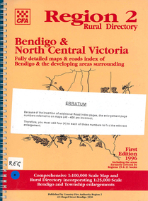
Map, Country Fire Authority, Region 2 rural directory : Bendigo &? North Central Victoria: fully detailed maps &? roads index of Bendigo &? the developing areas surrounding, 1996
... : Bendigo &? North Central Victoria: fully detailed maps &? roads ...mapsbendigo, loddon, fire protection, victorian regional maps, directories -
Creswick Campus Historical Collection - University of Melbourne
Map, c.1930?
30 topographical maps, etc dating from 1930's. Subjects: Bendigo, Bendock, Castlemaine, Colbinabbin, Corio, Creswick, Dartmoor, Daylesford, Dunolly, Geelong, Gembrook, Glenmaggie, Juliet, Kaye, Maryborough, Murchison, Ringwood, Stratford, WalhallaMapsSchool of Botany, Univerity of Melbourne -
 Ballarat Tramway Museum
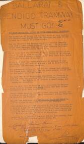
Pamphlet, R J Nowell, "Ballarat and Bendigo Tramways Must Go", 1961 or 1967
Has a strong association with the person who created the document and his viewpointsPamphlet - photocopied onto fragile heat sensitive paper - now brown - foolscap sheet, titled "Ballarat and Bendigo Tramways Must Go" Issued by R J Nowell of 15 Selwyn St Elsternwick in the interest of better public transport. Seeks better transport in both cities, gives his reasons for such a move, the loss incurred by the SEC. Even suggests horse trams would be cheaper to operate. Undated - has a hand written note regarding it being received at a SEC office on Monday 4/9. Monday 4/9 occurred during 1961 and 1967. Note the Melbourne Tram Museum has a Melbourne tram map prepared by the same person at Selwyn St Elsternwick - see their Reg Item 1381. trams, tramways, closure, pamphlets, ballarat, bendigo, costs, safety -
 Ballarat Tramway Museum
Document - Folder with papers, Bendigo Tramways, "Bendigo", Dec. 1994
Folder folded cardboard, yellow cover by the Bendigo Tourism Board with papers for the 1994 COTMA Conference from 2nd to 7th December 1994. Contains a general info sheet, programme, bus schedule, maps, list of delegates and hand written notes on the sessions. Has "KS 9-8-94 and 2/12" in ink.trams, tramways, cotma, bendigo, conferences -
 Ballarat Tramway Museum
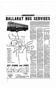
Poster, Transport Regulation Board, Ballarat Bus Services", Aug. 1971
Yields information about the closure of the Ballarat Tramway system and the bus replacements made by the Transport Regulation Board, can be compared to that for Bendigo and Geelong.Poster, titled "Ballarat Bus Services" printed on off white gloss paper. Produced shortly before the closure of the State Electricity Commission of Victoria operated Ballarat Tramway system. Gives details of the replacement bus services as well as the existing bus services and other changes planned. Provides notes on the operator, timetables, fares, route numbers and dates when the services would be changed. Map shows the bus routes, route numbers, section points and City stands and stops. Authorised by the Secretary of the Transport Regulation Board B. P. Kay. pdf file has to be opened outside dbTextWorks.trams, tramways, ballarat, map, closure, buses -
 Ballarat Tramway Museum
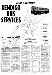
Poster, Transport Regulation Board, Bendigo Bus Services", Feb. 1972
... to that for Ballarat Trams tramways Bendigo Map Closure Buses Digital print ...Yields information about the closure of the Bendigo Tramway system and the bus replacements made by the Transport Regulation Board, can be compared to that for BallaratDigital print of a scanned Poster, titled "Bendigo Bus Services" printed on white paper. Produced shortly before the closure of the State Electricity Commission of Victoria operated Bendigo Tramway system. Gives details of the replacement bus services as well as the existing bus services and other changes planned. Provides notes on the operator, timetables, fares, route numbers and dates when the services would be changed. Map shows the bus routes, route numbers, section points and City stands and stops. Authorised by the Transport Regulation Board. trams, tramways, bendigo, map, closure, buses -
 Ballarat Tramway Museum
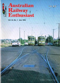
Magazine, William. F. Scott, "Australian Railway Enthusiast - Vol 32, No. 2, June 1994", Jun. 1994
... by the Bendigo Trust, maps and a list of the Bendigo Trust fleet. Front..., SEC takeover, closure, operation by the Bendigo Trust, maps ...Copy of the Australian Railway Enthusiast - Vol 32, No. 2, June 1994 which has an extensive photographic article on the Bendigo Tramways written by William F. Scott. Gives the origin of the city, first tramway, battery trams, steam trams, electrification, operation by ESCo, SEC takeover, closure, operation by the Bendigo Trust, maps and a list of the Bendigo Trust fleet. Front cover photograph of SEC cars 24 and 26 crossing on the Eaglehawk line.trams, tramways, bendigo, steam trams, battery trams, esco, sec, bendigo trust -
 Ballarat Tramway Museum
Slide - 35mm slide/s - set of 4, Noel Simons, Apr. 1972
Set of 4 transparencies - copy slides - possibly ARE film strip dated March 1972. 1209.2 and 1209.4 on Kodak Readymount mounts. 1209.1 - Bendigo 5, 6 and 28 on a special tram service in bound to the City on a tour in Caledonia St. about to enter Lucan St, or White Hills Road or Weeroona Ave. (mis match in names in various maps). Gas works in the background. No. 5 has a white disk on the rear of the tram. 1209.2 - Nos 2 and 26 at Charing Cross with the Fountain Plaza in the background. Both trams have the destination of Quarry Hill, though 26 is on the Eaglehawk bound track. 1209.3 - No. 19 at the Golden Square terminus, with the conductor or driver swinging the pole and Billy Rodda's Golden Square hotel in the background. 1209.4 - No. 7 at Fire Station loop, en route to North Bendigo, picking up a passenger with a pram. Part of a set of 20 slides made by the Association of Railway Enthusiast Provincial Tramways film strip. Reference Item 2560 details the ARE Film Strip and provide references to other slides.Information written on in blue ink and date stamped on purple ink. 1209.1 - "Nos 5, 6 and 28 in Caledonia St. about to enter Weeroona Ave." 1209.2 - "Nos 2 and 26 at Charing Cross." 1209.3 - "Swinging the pole on No. 19 at Golden Square Terminus." 1209.4 - "No. 7 inward bound from Golden Square stops at Fire Station Loop."tramways, trams, bendigo, charing cross, golden square, gas works, special trams, tram 2, tram 5, tram 6, tram 7, tram 19, tram 28 -
 Ballarat Tramway Museum
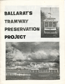
Book, Campbell Duncan, "Ballarat's Tramway Preservation Project", 1978?
Sixteen page book or booklet printed on A4 white paper, folded to A5 with saddle bound staples, titled "Ballarat's Tramway Preservation Project". Written by Campbell Duncan for the BTPS c1978, giving details of the history of Ballarat's tramways, and a brief history of Geelong and Bendigo, the formation and operations of the BTPS and the tramcar fleet. Has 10 photographs, 1 sketch of the front of a maximum traction tramcar and a map of the BTPS location on the rear. Map drawn by G. Inglis 2.73. Note no credits for photographs. See image files for photos used in book. Second edition - notes tram 28 has been repaired by the BTPS and this did not occur until 1978 - only gives 6 tramcars in list - we had others stored off site at the time. second copy added 1/1/12trams, tramways, btps, museum directory, car fleet, map -
 Ballarat Tramway Museum
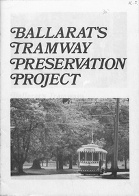
Book, Campbell Duncan, "Ballarat's Tramway Preservation Project", 1973
12 page booklet describing the Ballarat Tramway Preservation Society's Preservation project of the former Ballarat trams. Features 8 photos with notes on Ballarat, Bendigo systems. Also notes on the BTPS and its fleet of six trams. Rear page has map by G.Inglis showing access line under construction. Image files of front and back covers. Two further copies added 18/8/2002 - from Richard Gilbert's papers.trams, tramways, ballarat, btps -
 Ballarat Tramway Museum
Book, Campbell Duncan, "Ballarat's Tramway Preservation Project", 1975
16 page booklet describing the Ballarat Tramway Preservation Society's Preservation project of the former Ballarat trams. Features 10 photos with notes on Ballarat, Bendigo systems. Also notes on the BTPS and its fleet of six trams. Rear page has map by G.Inglis showing access line completed. Has 50c sticker on front cover. See Also Reg. Item 1754 for the 2nd edition. Copy 2 added 9-11-2018 from donation of Glenise Kellett.trams, tramways, ballarat, btps -
 Ballarat Tramway Museum
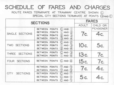
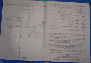
Poster, State Electricity Commission of Victoria (SECV), "Schedule of Fares and Charges - August 1966", Aug. 1966
Demonstrates an aspect of the SEC method of advising fares and sections to the travelling public. Also gave a small map that would have been useful to crews to explain to visitors where things were. Used in tramcars when trimmed. This poster made for the 1966 or second last fare increase. A similar arrangement used on Bendigo tramcars.Dyeline print of a drawing showing Ballarat Tramway (SEC) Fares, Charges, and Section Map. Also gives charges for Scholar's Monthly tickets, Luggage, Parcels, Newspapers and Chartered trams. Originally dated August 1965, amended August 1966. Note only shows decimal currency. Fares were applicable from 1/9/1966. Titled - "Schedule of Fares and Charges - August 1966" 2nd copy added 1/5/2001 - In good condition and images added as well. 3rd copy added 3-8-2006 - BTPS Cat. No. 608 - folded into four. For map - see blrtfcmap.jpg and for actual fare tables, btm705i1.jpg, btm705i2.jpg"BTPS 608" on outside of folded sheet in black ink and "Ballarat Tramway Preservation Society Catalogue No. 608" on top right hand corner of sheet.trams, tramways, ballarat, fares, sections, map -
Ballarat Tramway Museum
Magazine, Australian Electric Traction Association (AETA), "Electric Traction", 1951, 1953
Ten issues of "Electric Traction" of the Australian Electric Traction Association. 1303.1 - Vol VI, No. 4, April 1951 - printed covers with four pages of duplicated notes - in poor condition, torn along centre and some edge damage. Page 3 includes notes on the Provincial systems about bogie cars going to Ballarat, Bendigo and Geelong. 1303.2 - Vol VI, No. 5, May 1951- printed covers with four pages of duplicated notes - in fair condition - covers have yellowed. 1303.3 - Vol VI, No. 6, June 1951 - as for 1303.2 - in good condition - some foxing on covers. 1303.4 - Vol VI, No. 7, July 1951 - as for 1303.2 - in good condition, though the insert pages have suffered some edge damage as slightly larger in size than the printed covers. 1303.5 - Vol VI, No. 8 - August 1951 - as for 1303.2 - in good condition - includes an article on page 3 about Ballarat news - including relaying of Sturt and Drummond Sts junction, service cuts, fare increase, No. 23, and extension of the depot to accommodate bogie cars. 1303.6 - Vol VI, No. 9 - September 1951 - 8 pages all printed - includes on page 3 - item re Ballarat No. 23 withdrawn for scrapping, and bogie cars at Geelong. In good condition. 1303.7 - Vol VI, No. 12 - December 1951 - 6 printed pages - includes items re bogie cars at Ballarat, Bendigo and Geelong. In good condition. 1303.8 - Vol VIII, No. 8 - August 1953 - 6 printed pages with green title details - has an item that Wal Jack was recently given a front page write up in the Courier. Shown as being printed by "Traction Press" of the same address as the publisher - Traction Publications. In good condition. 1303.9 - Vol VIII, No. 9 - September 1953 - 8 printed pages with black title details, page 3 has map of Sydney printed in red and page 6, Sydney rail system. Page 4 has item re the Geelong system and a forthcoming Transport Regulation Board inquiry. In good condition though has been folded in the middle. Printer as for 1303.8 1303.10 - Vol VIII No. 2 - February 1953 - 6 printed pages - includes Tramways of Collie WA, Sydney News, Melbourne cable car conversion dates, electric railway news and branch news and notes Basil Miller has been appointed as an Inspector in Bendigo. 1303.10 - added 28/3/2010 - sourced from donations to the Museum by R. Elliston 28-3-16.Items 1303.2 to 1303.7 - have the stamp of the "The New Zealand Railway & Locomotive Society" on the front cover.trams, tramways, electric traction, aeta, ballarat, australian tramways, bendigo, cable trams -
 Ballarat Tramway Museum
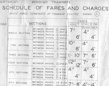
Poster, State Electricity Commission of Victoria (SECV), "Schedule of Fares and Charges - 11 August 1965", Aug. 1966
... Sections Map Dye line print of a drawing showing Bendigo Tramways ...Dye line print of a drawing showing Bendigo Tramways (SEC) Fares, Charges, and Section Map. Also gives charges for Scholar's Monthly tickets, Luggage, Parcels, Newspapers and Chartered trams. Dated 11 August 1965. Fares in shillings and pence and decimal currency. Titled - "Schedule of Fares and Charges - 11August 1965". Shows offices as Hargreaves St. For map - see bgofsmap.jpg and for actual fare tables, btm1732i1.jpg and btm1732i2.jpg. .1 - Second copy from Ron Fluck, added 26/9/2008. Note: 1732 - first copy stored rolled, 1732 - 2nd copy stored flat in box at bottom of rolls. .2 - as above but mounted onto a heavy card sheet with wear marks along the bottom edge - see image i3. Stored as for the 2nd copy. Note: 1732 - first copy stored rolled, 1732 - 2nd copy stored flat in box at bottom of rolls, .3 dittotrams, tramways, bendigo, fares, sections, map -
 Ballarat Tramway Museum
Slide - 35mm slide/s, Peter Moses, Jan. 1969
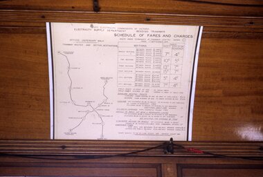
... On the rear of the slide "Jan. 1969 Bendigo/ Map of Routes... Bendigo/ Map of Routes" in blue ink, "P. Moses" in black ink ...Photo of the SEC Bendigo "Schedule of Fares and Charges" inside a tram. The fare chart appears to have been mounted on a large sheet of white cardboard. Note the red tape joining the bell cord. Kodak cardboard mount slide, taken by Peter Moses, Jan. 1969.On the rear of the slide "Jan. 1969 Bendigo/ Map of Routes" in blue ink, "P. Moses" in black ink and other side of the slide in red ink “1”.tramways, trams, bendigo, schedule of fares, map, fares -
 Ballarat Tramway Museum
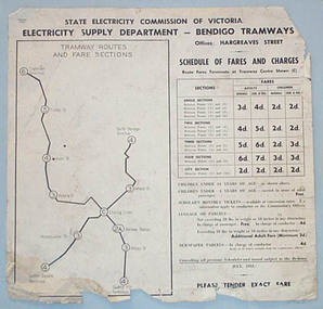
Poster, State Electricity Commission of Victoria (SECV), "Schedule of Fares and Charges - July 1951", Jul.1951
... behind framed glass. Trams tramways Bendigo Fares Sections Map ...Demonstrates the way the SEC advised passengers in Ballarat and Bendigo how the fare and charges systems worked and yielded information about the fare charges in force at the time. A copy was provided in each tram behind framed glass.Printed sheet and mounted onto at least two other sheets of heavy blank paper to form a poster of a drawing showing Bendigo Tramways (SEC) Fares, Charges, and Section Map. Also gives charges for Scholar's Monthly tickets, Luggage, Parcels, Newspapers and Chartered trams. Fares in shillings and pence and decimal currency. Titled - "Schedule of Fares and Charges - July 1951". Shows offices as Hargreaves St. Has details of designer/draftsman and date "AVM/MM / 14/5/51" in top left hand corner. See images for digital photographs of the poster. Stored within a purpose made folder. In very poor order.trams, tramways, bendigo, fares, sections, map -
 Ballarat Tramway Museum
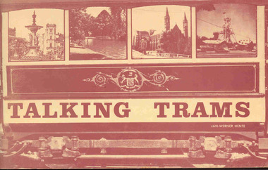
Book, Jan-Werner Hente, "Talking Trams", 1973
Ninety six page book stapled with a heavy card cover, saddle stapled, printed on matt paper, titled "Talking Trams" and written by Jan-Werner Hente. Has a number of pages of light manila colour paper stock printed with a sepia ink. Many black and white photographs. Major Sections include: Pages 7 - 24 - text as if on a "Talking Tram" tram tour of the Bendigo Trust tram., with relevant photographs. Pages 26 - 47 - details briefly the history of each tramcar in the fleet at the time and some scrapped trams. Pages 48 - 49 - map of the route with reference points. Pages 52 - 69 - "If only all trams could talk" - the story of the trams in Bendigo and its mining history, including horse, battery, steam and electric trams, Victorian Railways impact and some of the personalities of the Bendigo Tramways. Pages 70 - 92 - the SEC era and closure and the early Bendigo Trust days Pages 93 - 96 - provides a rolling stock listing - all Bendigo trams. Has a Corrigenda sheet glued to the inside of the front cover. Two copies held. On the top right corner of the title page in black ink "Ex ARHS Archives".trams, tramways, bendigo trust, bendigo, sec, tourist trams -
 Ballarat Tramway Museum
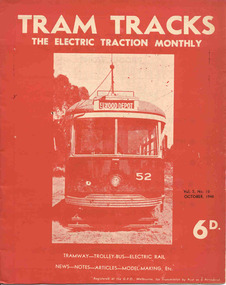
Magazine, Jack Richardson, "Tram Tracks - The Electric Traction Monthly", July to Dec 1948
Three issues of "Tram Tracks - The Electric Traction Monthly" of the Australian Electric Traction Association. Each issue has a standard cover, of the magazine name etc, and featuring a front end photo of Victorian Railways tram No. 52 with the destination of Elwood but are in different colours, all have been saddled stapled with a single staple. The Volume and date details have been over printed. Back covers inside covers have the same advertisements. The three issues contain advertisements for the Wee Folks productions, Wattle Park, G&R model railway parts, Richard Noble model electric motors, Hobbyco, Fleet scale model railway equipment, Masseys Sports, Lloyd's Hobbycraft, John Martin Ltd, Johnson's Variety Store, the ARLHS, Barnes Tennis Centre, The Model Dockyard, the American Subscription Agency, Robilt Models, Meadmore Model Engineering and Austral Bronze Pty Ltd, Hearns Hobbies, Christie Scale Model Railway Products and Traction Publications. 2466.1 - Vol. 3 No. 10 - 20 pages, Oct. 1948, with cover printed in red ink. Has articles on anti-tram propaganda, Alphington - Heidelberg duplication and Sydney's early electric trams - C and D class. Also has news items on Brisbane, Newcastle, Sydney, Melbourne, Sandringham - Black Rock, Hobart, Launceston, Perth, Sydney and Melbourne electric trains, Launceston Trolley Buses, AETA notes, and a caricature of the Editor, Jack Richardson. 2466.2 - Vol. 3 No. 11 - 24 pages, Nov. 1948, with cover printed in blue ink. Has articles on construction of tram track in Melbourne (Victoria Parade), Bourke St., tram-bus controversy, (Reg Ansett, Noel Gipps and USNR Commander Quinby), Sydney's early electric trams - C and D class continued. Also news items on Last tram to Mayfield, Sydney, Latrobe St. Melbourne, Adelaide, opening to Alamein, Melbourne show traffic, VR Trams and AETA notes. 2466.3 - Vol. 3 No. 12 - 16 pages, Dec. 1948, with cover printed in green ink. Has articles on Sydney's electric railways, Brisbane Tramways and an AETA Melbourne tour. News items cover Sydney, Newcastle, Melbourne, Geelong, Bendigo, Kalgoorlie, Melbourne and Sydney trains and AETA news. 2466.4 - Vol 3 - No. 7 - 20 pages - July 1948 with cover printed in red ink. Has articles on cost of building trams for Brisbane, Sydney and Melbourne, abandonment of VR trams, Newcastle, Sydney, centre page photo of Y1 611, Sydney Electric train system including map and AETA news. 2466.5 - Vol 3 - No. 9 - 20 pages - Sep 1948 with cover printed in blue ink. Has articles on Mr. T. G. Patterson, Acting Director of Commonwealth Road Transport and Chairman of Federal Road Safety Council (very anti tram), news from Brisbane, Launceston, Sydney, Newcastle, Burwood, cost of trams, impressions of transport in Europe and North America, Melbourne and Sydney electric trains, tramways of Newcastle and model notes and AETA news. 2466.6 - Vol. 3, No. 1 - Jan 1948 - 16 pages with photo of Brisbane 407, political news, direct Melbourne to Footscray line proposal, new trams, bogie trams in Ballarat, article on Melbourne cable trams, electric trains, AETA outing in Melbourne and various adverts for model railways. 2466.7 - Vol 3 No. 2 - Feb. 1948 - 16 pages - political news, Ballarat news, traffic in Sturt St and new bogie cars, Christchurch closure, cartoon by Mercier on Sydney Honesty box, Brisbane suburban electrification, general tramway and electric railway news and various adverts for model railways. 2466.8 - Vol. 3 No. 3 - March 1948, with photo of VR 52 on front cover, 16 pages, political news, closures, Reg Ansett offer to buy the Melbourne bus system, Newcastle News, SEC Transfer of cars between the three systems, tramways in the Maribyrnong area, map of Melbourne trams, cartoon by Mercier, Brisbane train electrification and general news. 2466.9 - Vol. 3 No. 6 - June 1948 - 12 pages - MMTB political news, new trams for Sydney, tramways of Newcastle, Invercargill, Sydney Suburban trains, and AETA General news. .6 to .9 added 24-3-18 - from consolidation of Melbourne Tram Museum and BTM collections - ex AETA. trams, tramways, electric traction, aeta, models, australian tramways, melbourne, sydney, brisbane, newcastle, costs, ballarat, footscray -
 Ballarat Tramway Museum
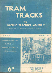
Magazine, Jack Richardson, "Tram Tracks - The Electric Traction Monthly", Feb. 1949 to August 1949
2467.1 - Vol. 4 No. 2, February 1949 of "Tram Tracks - The Electric Traction Monthly" of the Australian Electric Traction Association. Magazine consists of 16 printed pages with a 12 page supplement titled "Fifty Questions and Answers about trams in Australia". Has a single staple on the saddle. Incorporated within the magazine are articles or editorials on Tramways and Tramway Experts (Sydney and bus replacement), Interurban to St Kilda (conversion of VR St. Kilda line). General news items on Brisbane, Geelong, Launceston closure, Hobart, Bourke St routes, Perth, Adelaide, NSW, Christchurch, Overseas tramways and railways. Also has letters to the Editor, plans of a Birney tram for model makers and AETA Notes. Issue has advertisements for the Model Dockyard, ARLHS, The Hobby Shop, Barnes Tennis Centre, Fleet, Christie Model Railway Equipment of Sydney, Meadmore Model Engineering, Austral Bronze, Wattle Park, Traction Publications and Robilt "O" gauge locomotives. 2467.2 - Vol 4, No. 5 - May 1949 - 20 pages - red cover, 4th year, article by Peter Duckett with photos of Board members, "PCC Trucks here", MMTB advert for staff, news from Sydney, Newcastle, Melbourne (applications for new Chairman to replace Mr. Bell), Bendigo, Perth, Christchurch, Wellington, Wanganui, Bourke St construction work (photo of poles), Brisbane tramway history, map of CBD Melbourne, Melbourne and Sydney suburban railways, AETA News. 2467.3 - Vol 4, No. 6 - June 1949 - 16 pages - green pages, tramways and private cats, news from Sydney, Newcastle, Melbourne, Launceston, Hobart, article "Scrap Sydney Tams by 1960 - Newcastle this years say London experts", buses tackle football crowds (Sydney), Fremantle (Wal Jack letter), and Melbourne and Sydney suburban railways, AETA News. 2467.4 - Vol 4, No. 7 - July 1949 - 16 pages - tramways and the public, news from Sydney, Newcastle, Melbourne, appointment of R. Risson as new chairman, Perth, Adelaide, Launceston, tramcar solenoid brakes, National City Lines USA, and Melbourne and Sydney suburban railways, AETA News. 2467.5 - Vol 4, No. 8 - August 1949 - 8 pages - tramways and politics, photo of new points for Latrobe and William Sts, East Hills Line by C. C. Singleton, general tramway news, and advertisement for Robilt model railways. .2 to .4 added 15-2-2016 from the collection of Ian Stanley. .5 added 24-3-18 - from consolidation of Melbourne Tram Museum and BTM collections)trams, tramways, electric traction, aeta, australian tramways, mmtb, pcc, closure, sydney, newcastle, brisbane -
 Ballarat Tramway Museum
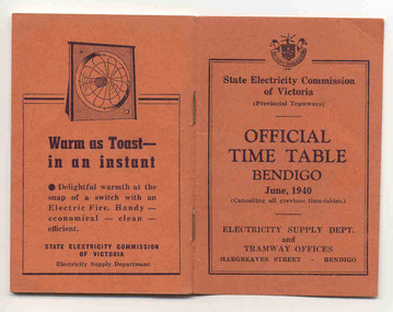
Ephemera - Timetable/s, State Electricity Commission of Victoria (SECV), "Official Time Table Bendigo June 1940", Jun. 1940
Centre pages show a map of the system and the sections. The extension to North Bendigo is yet to be constructed. Gives times for trams leaving the city or the terminals for the routes and for the Eaglehawk route, leaving Long Gully Bridge. Has four SECV Advertisements within the book for hot water, ovens - cookers, toasters and electric fan heaters. Three copies held. See item 5356 for a digital image of the same document with a photograph of Len Smith of Geelong loading a pram into a Birney tram.Provides details of 1940 tram services in Bendigo.Forty-page booklet, with orange lightweight covers, saddle-stapled, SECV Provincial Tramways with the title "Official Time Table Bendigo June 1940". Has address if Hargreaves St Bendigo on bottom of the cover. Two copies held.bendigo, timetables, secv -
 Ballarat Tramway Museum
Poster, State Electricity Commission of Victoria (SECV), "Schedule of Fares and Charges - January 1962", Jan. 1963
Demonstrates the way the SEC advised passengers in Ballarat and Bendigo how the fare and charges systems worked and yielded information about the fare charges in force at the time. A copy was provided in each tram behind framed glass.Dyeline print of a drawing showing Ballarat Tramway (SEC) Fares, Charges, and Section Map. Also gives charges for Scholar's Monthly tickets, Luggage, Parcels, Newspapers and Chartered trams. Originally dated November 1955, amended January 1962. All fares in shillings and pence. Titled - "Schedule of Fares and Charges - January 1962" See Reg Item 1731 for the following one, which this version amended again and 4136 for the November 1955 version. Two additional copies found in depot collection 1/2011, added 5/1/2011. Has a pencil inscription "Fares didn't increase to 1/3/63" along site the date. Copies 2 and 3 no inscriptions.trams, tramways, ballarat, fares, sections, map