Showing 11163 items matching "planning "
-
 Kew Historical Society Inc
Plan - Subdivision Plan, Goldthorns House Estate, 1940
Pru Sanderson, in her groundbreaking ‘City of Kew Urban Conservation Study : Volume 2 - Development History’ (1988), summarised the periods of urban development and subdivisions of land in Kew. The periods that she identified included 1845-1880, 1880-1893, 1893-1921, 1921-1933, 1933-1943, and Post-War Development. These periods were selected as they represented periods of rapid growth or decline in urban development. An obvious starting point for Sanderson’s groupings involved population growth and the associated economic cycles. These cycles also highlighted urban expansion onto land that was predominantly rural, although in other cases it represented the decline and breakup of large estates. A number of the plans in the Kew Historical Society’s collection can also be found in other collections, such as those of the State Library of Victoria and the Boroondara Library Service. A number are however unique to the collection.The Kew Historical Society collection includes almost 100 subdivision plans pertaining to suburbs of the City of Melbourne. Most of these are of Kew, Kew East or Studley Park, although a smaller number are plans of Camberwell, Deepdene, Balwyn and Hawthorn. It is believed that the majority of the plans were gifted to the Society by persons connected with the real estate firm - J. R. Mathers and McMillan, 136 Cotham Road, Kew. The Plans in the collection are rarely in pristine form, being working plans on which the agent would write notes and record lots sold and the prices of these. The subdivision plans are historically significant examples of the growth of urban Melbourne from the beginning of the 20th Century up until the 1980s. A number of the plans are double-sided and often include a photograph on the reverse. A number of the latter are by noted photographers such as J.E. Barnes.The first subdivision of Goldthorns created the Goldthorns Hill Estate. Following that subdivision, seven additional lots were offered between Normanby Road, Argyle Road and Lady Loch’s Drive on the proviso that the estate, including Goldthorns was not sold as a single lot. The subdivision plan advises that the lots are situated in one of the most charming and popular residential areas in Kew and is surrounded by modern homes. Typically, the subdivision plan proposes the advantage of its proximity to Cotham Road and the tram to Collins Street. Because of the elevation of Goldthorns, much is made of the ‘bright, sunny and extensive outlook to the Northern Ranges’ and that it overlooks the Yarra Valley. One of the more interesting aspects of the plan is that it shows the outline of Goldthorns in the mid to late 1920s. Its profile today remains virtually the same."Goldthorns" House Estate at topsubdivision plans - kew, goldthorns house estate -
 Kew Historical Society Inc
Plan, Sydney Arnold Best & Co, Field Place, Kew, c.1929
Pru Sanderson, in her groundbreaking ‘City of Kew Urban Conservation Study : Volume 2 - Development History’ (1988), summarised the periods of urban development and subdivisions of land in Kew. The periods that she identified included 1845-1880, 1880-1893, 1893-1921, 1921-1933, 1933-1943, and Post-War Development. These periods were selected as they represented periods of rapid growth or decline in urban development. An obvious starting point for Sanderson’s groupings involved population growth and the associated economic cycles. These cycles also highlighted urban expansion onto land that was predominantly rural, although in other cases it represented the decline and breakup of large estates. A number of the plans in the Kew Historical Society’s collection can also be found in other collections, such as those of the State Library of Victoria and the Boroondara Library Service. A number are however unique to the collection.The Kew Historical Society collection includes almost 100 subdivision plans pertaining to suburbs of the City of Melbourne. Most of these are of Kew, Kew East or Studley Park, although a smaller number are plans of Camberwell, Deepdene, Balwyn and Hawthorn. It is believed that the majority of the plans were gifted to the Society by persons connected with the real estate firm - J. R. Mathers and McMillan, 136 Cotham Road, Kew. The Plans in the collection are rarely in pristine form, being working plans on which the agent would write notes and record lots sold and the prices of these. The subdivision plans are historically significant examples of the growth of urban Melbourne from the beginning of the 20th Century up until the 1980s. A number of the plans are double-sided and often include a photograph on the reverse. A number of the latter are by noted photographers such as J.E. Barnes.An unnamed subdivision in Studley Park including five lots for sale in Studley Park Road, Highfield Grove and Tara Avenue. Unidentified on the plan, but clearly existing, are the Henty family mansion of Field Place and Tara Hall in Studley Park Road. The first attempted subdivision of Tara Hall was advertised in 1927 in which Lots 5, 6 and 7 in this plan were also advertised. Unusually, Lot 2 in Studley Park Road was created from the northern part of the Henty mansion, rather than Tara Hall. In the subdivision, lots were advertised at varying prices, with the highest price for land being Lot 2 in Studley Park Road. The plan notes that only one villa is to be allowed on each allotment.subdivision plans - kew, field place subdivision -- studley park – kew (vic.), highfield grove – kew (vic.), tara avenue – kew (vic.) -
 Melbourne Tram Museum
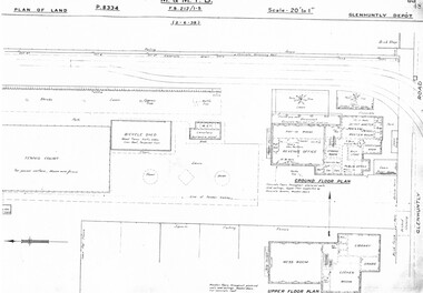
Drawing, Melbourne & Metropolitan Tramways Board (MMTB), "Glenhuntly Depot", c1937
Set of three photocopied plans or drawings on A3 sheet of "Glenhuntly Depot" - c 1938 .1 - P8334 - Plan of land showing details of offices and tennis court - 2-6-1938 .2 - P8335 - Plan of land showing car depot layout and associated buildings - 2-6-1938 - shows substation location. .3 - P8333 - Plan of land showing MMTB land and surrounding properties. - 2-6-1938trams, tramways, drawings, depots, property, glenhuntly tram depot, substation -
 Linton and District Historical Society Inc
Floor plan, Floor plan of Railway Hotel, Linton, 1953
Architectural drawing showing block and floor plan of Linton's Railway Hotel. The plan appears to have been drawn up for the Ballarat Brewing Company, which owned the hotel, in connection with proposed renovations. Plan is initialled "J. O. O'B." and dated"5.5.53". Plan shows bar area, parlours and dining rooms, residential areas, ablutions areas, staff bedrooms, rooms used for accommodation, and outbuildings (stable, garage etc.).railway hotel linton, maps and plans, floor plans -
![Map, Plan showing proposed deviation of the road through McKenzie's Flat to Bacchus Marsh. [Undated]](/media/collectors/5e461d8021ea67224c82f2a1/items/677d22f37f2053f3e5d500dc/item-media/677d25247f2053f3e5d50950/item-fit-380x285.jpg) Bacchus Marsh & District Historical Society
Bacchus Marsh & District Historical SocietyMap, Plan showing proposed deviation of the road through McKenzie's Flat to Bacchus Marsh. [Undated]
The date of this map or plan is uncertain. McKenzie's Flat is a bushland picnic area on the Lerderderg River in the Lerderderg State Park close to Bacchus Marsh. The proposed road deviation shown on this map is very close to a sharp bend in the Lerderderg River which shows an island in the centre of that bend. The name of a landholder, J.B. Perry is shown on the map close to the area of the road deviation.The land shown is identified as within the Parish of Merrimu.Single page map showing a proposed deviation of the road from McKenzie's Flat to Bacchus Marsh. Scale: 5 chains to 1 inch. Part of a set of maps which are pasted into a bound volume containing 76 maps or plans in total. High resolution digital image stored on BMDHS computer network. mckenzies flat bacchus marsh, bacchus marsh roads and streets -
University of Melbourne, Burnley Campus Archives
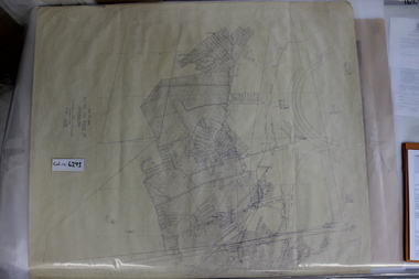
Plan (item) - Plans Burnley Gardens, Department of Agriculture - Victoria Burnley Gardens
-
Port Melbourne Historical & Preservation Society
Plan, Graeme Bentley Pty Ltd, Port Melbourne Foreshore Landscape Master Plan MP4 (B), February 1993
The Port Melbourne Foreshore Landscape Master Plan was created by Landscape Architectural firm of Graeme Bentley Pty Ltd for the City of Port Melbourne. MP4 (B) portrays the section of foreshore Surrounding the Port Melbourne Lifesaving Club.The plan proposed street tree planting and lawn areas. The plan was not actioned.built environment - recreational facilities, beach street, port melbourne foreshore, port melbourne life saving club -
Port Melbourne Historical & Preservation Society
Plan, Graeme Bentley Pty Ltd, Port Melbourne Foreshore Landscape Master Plan MP2 (A), February 1993
The Port Melbourne Foreshore Landscape Master Plan was created by Landscape Architectural firm of Graeme Bentley Pty Ltd for the City of Port Melbourne. MP2 (A) portrays the section of foreshore from Stokes Street to Dow Street. The plan proposed street tree planting along Beach Street. The plan was not actioned.built environment - recreational facilities, beach street, port melbourne foreshore, station pier -
 Federation University Historical Collection
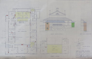
Plan, School of Mines Ballarat Old Supreme Court Building, 1959, 26/10/1959
Copy of a plan and elevations of the former Ballarat Supreme Court, later a building of the Ballarat School of Mines. The plans were for repairs and painting of the Old Electrical School of the Ballarat School of Mines. former ballarat supreme court, electrical school, ballarat school of mines, painting -
Port Melbourne Historical & Preservation Society
Map - MMBW, 1894
Melbourne and Metropolitan Board of Works 1894 Plans No. 338, 339, 355, 356 Segments shown: As plan No's: Bridge to Graham, Evans to Nott. (Large scale - 40'=1")311/H, 17engineering - board of works, built environment, education - primary schools, graham street state school, port melbourne primary school, business and traders - hotels -
 Coal Creek Community Park & Museum
Mine Map, 1942
6291.1 - Plan of "Austral Coal Mining Co" Lease in Korumburra detailing the mine tunnel plan, coal seam areas and some surface features such as railway sidings & Leura Creek. -
Bendigo Historical Society Inc.
Map - LEICHARDT, 23/05/1875
Map: Parish of Leichardt, County of Bendigo. Parish plan (coloured). Attached plan in the top left hand corner marked 'Building Lots' (number 323 in map cupboard 1)map, bendigo, building lots, leichardt -
Whitehorse Historical Society Inc.
Document, Forest Hill, 1/11/1992
Forest Hill Activity Centre Structure Plan Final Report. Prepared for City of Nunawading by Wilson Sayer Care Pty. Ltd. in association with Arup Transportation Planning November 1992.forest hill chase, wilson sayer core pty. ltd., arup transportation planning, shopping centres, city of nunawading, abbott, kevin -
University of Melbourne, Burnley Campus Archives
Plan - Sketch, Plan of Burnley Gardens, 1970-1980
Plans A and B. 2 identical hand drawn sketch plans of area bounded by manure bins, pumphouse to the east, milking shed and silo to the west: showing all buildings on the site.burnley gardens, buildings, burnley school of horticulture -
 University of Melbourne, Burnley Campus Archives
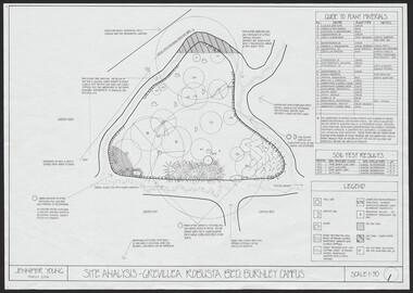
Plan, Jennifer Young, Grevillea Robusta Bed Burnley Campus, 2006
(1) Site Analysis by Jennifer Young, March 2006. (2) Plant Survey by Jennifer Young, March 2006. (3) Plant Plan - photocopy of rough hand-drawn planjennifer young, grevillea robusta, burnley horticultural college, landscaping, soil types -
 Bendigo Historical Society Inc.
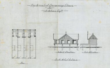
Plan - Architectural drawings for Burnewang Homestead, Elmore, No date visible
Burnewang was built in 1903 for the Holmes Family. It is situated on the banks of the Campaspe river a few kilometres east of Elmore.Set of five Architect drawings of the Burnewang, Elmore Homestead showing, Elevations, Floor plans, Garden Layout, Details of the Fencing and the Dog Kennel. The plans were prepared for H Holmes.H. Holmes Esq.buildings, house, architect drawing, burnewang, elmore, holmes -
University of Melbourne, Burnley Campus Archives
Plan - Photocopy, Contour Map 1891, 1891
Photocopy of plan showing contour lines from Yarra River. Shows Pavilion and Principal's Residence but not much of the garden design. From Central Plan Office Dept. of Natural Resources."Contour map 1891" written in biroyarra river, pavilion, burnley horticultural college, burnley gardens -
Port Melbourne Historical & Preservation Society
Document - Report, Ewan Ogilvy's Bayside Papers, Bayside EES Inquiry, Ewan Ogilvy's Bayside Papers, Box One, 1988
Ewan Ogilvy, former Melbourne Councillor and also of Community Services Victoria, Inner Urban Ministerial Advisory Committee and Uniting Church's Centre for Urban Research and Action (CURA), was instrumental in social justice approaches to town planning. He and CURA's Social Justice and the City Project funded Port Melbourne community groups protesting against the SCDC development in 1987. His files were presented to the Society in May 2001 on his preparation for leaving Victoria.From Ewan Ogilvy's chronologically organised 'Bayside Papers' relating to the proposed development of Port Melbourne industrial land in the late 1980s: EES Inquiry report to the Minister for Planning and Environment 7 April 1988, included in bound black file. Appendix 4: Bibliography; 7pp of documents and submissionsAll items signed 'Ewan Ogilvy'town planning, town planning - proposals shelved - bayside, public action campaigns, environmental issues, public housing, ewan ogilvy, centre for urban research and action, sandridge city development co pty ltd, scdc, linton r lethlean, judy arndt, francis b barnes -
 Lara RSL Sub Branch
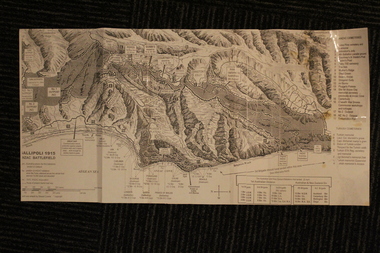
Group of Maps World War One, Group of Maps World War One - Dardanelles and Anzac Gallipoli Maps Circ 1915, Circ 1916
Gallipoli 1915 Maps and Naval plan of Operations World War One ANZACRare examples that explain both ANZAC and Naval Operations during World War One Gallipoli & Dardanelles Passage .!. Black and White Photocopy of Gallipoli 1915 ANZAC Battlefield - detailed positions of troops and Cemeteries. 2.The Allied Failure to Force The Dardanelles Passage 18 March 1915 - detailed line of Attack Naval Organisation, Mine layout, Plan of Attack (and copy).. 3. Map of Turkey and surrounding area written in Turkish and German Languages. C0olor version main roads and distances. (and copy).. 4. Map of ANZAC Trench Diagram. World War One.Color. (and copy). 5.Panorama of Chunuk Blair from 3 miles south of Nibrunesi Point, 3 November 1915 and Anzac from 1 mile N. E. of Ari Burnu, 21 November 1915. Black & White 6. Color Map of ANZAC positions with topographical Details, notes. 1. Artwork and copyright by Srewart Cownie, Gallipoli 1915 ANZAC Battlefield with Landings and later evacuation marked. 2. Details of Naval actions taken in the Dardanelles Passage 18 March 1918. 3. Local area Map or Turkey. Shows roads network and townships. 4. ANZAC Trench Diagram, copyright Whitcombe & Tombs Limited , Wellington N.Z. 1919 5. Panorama of two coast views of ANZAC area. Australian War Memorial, 6. Map of ANZAC positions of World War One, Gallipoli 1915. Published by H.E.C. Roberinson, George Street, Sydney N.S.W.18 April 1916maps operational of anzac and naval opations during 1915 etc, dardanelles naval opations -
Federation University Historical Collection
Plan, Mount Helen Campus Plan, 1997, 1997
The Union Building was later named the Albert Coates Centre, and the Aboriginal Education Centre moved from T Building to the first floor of the Albert Coates Centre in 2011. Mount Helen Campus Plan showing the location of buildings and roads. mount helen campus, campus plan, union builidng, aboriignal education unit, albert coated building -
Federation University Historical Collection
Plan, Ballarat School of Mines Botanical Garden Plan, 2016, 2016
The Ballarat School of Mines Botanic Garden was established in 1872.A PDF of a garden plan for the Ballarat School of Mines Botanical Gardenballarat school of mines botanical gardens, john patrick -
Federation University Historical Collection
Plan, Plan of Caxton Mine Battery Head, Smythesdale
Framed original plan of Caxton Mine battery head, Smythesdalecaxton mine battery head smythesdale, caxton mine, smythesdale, battery head, available -
 Federation University Historical Collection
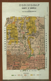
Plan - Parish Plan, Corindhap, County of Grenville, 1898
Colour Parish Plan of Corindhap, County of Grenville, and a report on the Parish.corindhap, dereel, warrambine, kuracaruc, commeralghip, rokewood, kuruc-a-ruc, w. elder, william elder, john thornly, robert cullen, davis aitcheson, robert gidney, john elder, w. barnard, anton trende, thomas hill, george hobson, h. reynolds, john collins, ironstone quarry, john jacka, patrick shanahan, murdoch mclennon, kaolinitic clay, kaolin, james holt, mary a. palmer, isaac everett, james mooney, michael cahill, fred benjamin, george hopkins, david houghton, john quarrell, j. camm, james macdonald, john thornley, break of day gully, john wilson, thomas middleton, alexander mcpherson, joseph coldwell, h. brand, pereverance co, puddling mils, mary a. stanbrook, c.w. stanbrook, eliza byrnes, james byrnes, j. maw, wallace douglas, john moffatt -
 Greensborough Historical Society
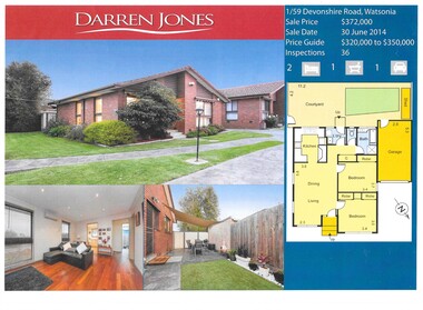
Advertising leaflet, Darren Jones Real Estate, 1/59 Devonshire Road Watsonia
Sold notice for 1/59 Devonshire Road Watsonia. Sold 30 June 2014 for $372,0001 p. leaflet, printed in colour. Includes floor plandevonshire road watsonia -
 Greensborough Historical Society
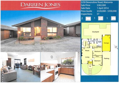
Advertising leaflet, Darren Jones Real Estate, 3/59 Devonshire Road Watsonia, 2014
Sold notice for 3/59 Devonshire Road Watsonia, sold 1 April 2014 for $$382,0001 p. leaflet, printed in colour, includes floor plandevonshire road watsonia -
 Greensborough Historical Society
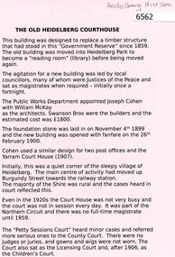
Document, The Old Heidelberg Courthouse, 2018_
The Courthouse is now the location of the Heidelberg Historical Society.2 p. black print on pink paper, building planheidelberg historical society, old heidelberg court house -
 Greensborough Historical Society
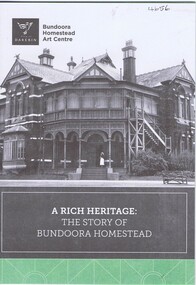
Pamphlet, City of Darebin, A Rich heritage: the story of Bundoora Homestead, 2016_
History of Bundoora Homestead, from its initial use by John Matthew Vincent Smith as a horse and cattle stud, and later as a convalescent farm and repatriation hospital until its ownership by Darebin City Council and restoration.10 p. pamphlet, col. & black & white photographs and plansbundoora homestead -
Glenelg Shire Council Cultural Collection
Plan - Plan - Portland Sewerage Association, n.d
Portland Sewerage Authority Plan of Drainage for Mrs M Campbellcampbell family records -
Glenelg Shire Council Cultural Collection
Plan - Plans - Cape Bridgewater Subdivision, n.d
Two identical photocopies of old plan of subdivision at Cape Bridgewater -
 Eltham District Historical Society Inc
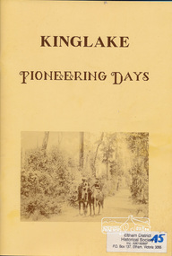
Book, Deidre G. Hawkins, Kinglake pioneering days / Deidre G. Hawkins, Editor, 1991c
Paperback; 72 pages : illustrations, plans, portraits ; 30 cm.kinglake, early settlers