Showing 110297 items matching "roads"
-
 Port Melbourne Historical & Preservation Society
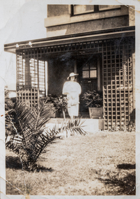
Photograph - Ellen Watters outside Williamstown Road home
The Watters family moved from Albert Park to Garden City Port Melbourne circa 1934 buying a Bank House at 128 Williamstown Road (later renumbered to 400). The family consisted of Bob Watters senior and his wife Ellen (nee Oakley), children Patsy (b 1920), Bob Junior (b 1922) and Norma (b1924). The children attended Albert Park Primary, Middle Park Central School and then MacRobertson Girls High School and Melbourne Boys High School.Digital photograph of Ellen Watters (nee Oakley) outside her home at 124 Williamstown Road (later renumbered to 400) ellen patricia watters -
 Whitehorse Historical Society Inc.
Document, Splendid home sites, 1938?
Sale brochure for 23 home sites and 'Gentleman's delightful country residence',.Sale brochure for 23 home sites and 'Gentleman's delightful country residence', frontages to Mitcham Road, Calcutta Street, Simla Street, Benares Street and Delhi Street. Agents: Baillieu Allard Pty Ltd and Drake & Co.Sale brochure for 23 home sites and 'Gentleman's delightful country residence',.walker estate, mitcham road mitcham, simla street mitcham, benares street mitcham, calcutta street mitcham, delhi street mitcham, drake & co., baillieu allard pty ltd -
Canterbury History Group
Photograph - View looking outside to Maling Road from inside No. 88 Maling Road, Jan Pigot, 27/03/1993 12:00:00 AM
Coloured photograph from inside the Maling Road Patisserie at No. 88 Maling Road looking through the front window to the shops across the road.canterbury, maling road, shops, street views -
 Kew Historical Society Inc
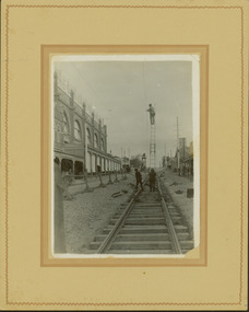
Photograph - Construction of the electric tram line in Glenferrie Road, Glenferrie, E.J. Dower, 1914
One of a series of photographs, taken by Edgar James Dower in the second decade of the twentieth century. Born and raised in Olinda, his family later moved to Surrey Hills. He worked as an adult as a clerk in the city office of the Metropolitan Gas Company, and in his role as a 'collector', he was able to photograph scenes including the construction of tramlines and associated buildings in Kew, Hawthorn, Camberwell and Surrey Hills. Later he established a real estate agency with his brother - the E.J. Dower Real Estate Agency, Dandenong Office.The image is an historically significant record of the development of transport infrastructure which was used to connect Victorians in the first two decades of the twentieth century. This development resulted from increases in population and the consequent extension of Melbourne's suburbs. The photographs, both individually and collectively, richly detail the labour of workers and the tools and machinery used to create and extend Melbourne's public transport network in the years preceding and during World War 1.Digital copy of an original mounted photograph showing a worker standing on a ladder in Glenferrie Road, Hawthorn, working on the overhead electric cables that would be used to power trams on the New Kew tramline.Other railway workers are working on platforms or viewing the man on the ladder. The ladder appears to be only supported by one other worker. "The Don Store" at left is immediately behind the old railway level crossing which can be seen in the distance to the south.Annotated verso: "Preparing for electric trams in Glenferrie Road, near Glenferrie Station, showing railway gates / Taken by E.J. Dower 1914"theme --- travelling by tram, theme -- connecting victorians by transport and communications, glenferrie road -- hawthorn (vic.), railways -- hawthorn -
 Whitehorse Historical Society Inc.
Photograph, Mitcham Memorial Hall
The Memorial Hall on Mitcham Road Mitcham, opened officially on Sunday 13 June 1926. The RSL used the hall until 1951, when it was sold to the Nunawading Council to be used as a community facility. In 1993 Nunawading Council sold the hall site.Three coloured photographs a-c of the Mitcham Memorial Hall (demolished). The statue of the soldiers in the foreground has been removed to Halliday Park, Mitcham. Whitehorse Road is in the foreground of each photograph.mitcham memorial hall -
 City of Moorabbin Historical Society (Operating the Box Cottage Museum)
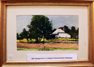
Print - 'Spring Grove' 19thC house, c1979
In 1852 Stephen Charman purchased 160 acres bounded by Charman Rd and Balcombe Road in an area called Spring Grove, later Cheltenham. A spring ran through the land providing a good source of water. Stephen aged 21 years had arrived in Melbourne 1842 as one of Henry Dendy’s emigrants . His Ship passage was paid by the Colonial Land and Emigration Commission and in return he was required to work on the land of the Henry Dendy Special Survey Brighton 1841. However Henry Dendy could not provide enough work for all the emigrants that arrived and Stephen had to obtain other work. Then sadly his young wife Harriett and their infant died. 1850 Stephen married widow Mary Gettens, a Publican in Little Collins Street, with 5 children. Stephen & Mary built a wattle and daub hut and established a market garden producing marigolds for Martin & Pleasance Pharmacists, Melbourne. They had 7 more children and built a weatherboard cottage that was used for early Methodist Church services. Stephen donated 1 acre to the Methodist Church in 1855 for Chapel , School and Cemetery. The picture of the weatherboard cottage was on, a road which runs from Cheltenham to Mentone it bears their name. Charman Road. Mary died in 1870 and Stephen remarried 1878 and died in Gippsland 1906. Stephen and Mary Charman were pioneer settlers in the area of Spring Grove later known as Cheltenham . Charman Road Cheltenham commemorates their contribution to the development of the area. A painting of 'Spring Grove' the home of Stephen Charman and Mary Charman formerly Gettens nee Rees, This cottage was the first house in Charman Road Cheltenham c1852signed L Schumerspring grove cottage 1852, schumer l, cheltenham, charman stephen, early settlers, jones a l, gettens mary, rees mary, charman mary, moorabbin, brighton -
 Bendigo Historical Society Inc.
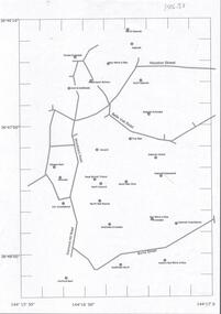
Document - CENTRAL DEBORAH GOLD MINE : GOLDEN SQUARE MINE SITES
Map showing mines in the Golden Square, Diamond Hill area. Roads include Diamond Hill Road, Burns Street, Woodward Road, Belle Vue Road, Houston Street. Latitude and Longitude on map.bendigo, mining, golden square mine sites -
 Bendigo Historical Society Inc.
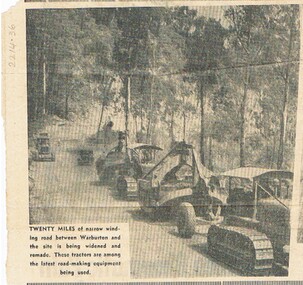
Newspaper - NORMAN PENROSE COLLECTION: ROAD MAKING MACHINERY
Newspaper. Norman Penrose collection: newspaper cutting depicting road making machinery on a road near Warburton. The road is being widened and remade. It is a bush road with a truck, a grader and two tractor towed scrapers.person, bendigo, norman william penrose, norman penrose collection, road making equipment -
 Ringwood and District Historical Society
Photograph, Composite Aerial Views of Ringwood, Victoria - 1972
Two composite black & white aerial photographs with north-facing view over Maroondah Highway, including Railway Station precinct, Civic Centre precinct, Eastland, Mount Dandenong Road, Bedford Road, Ringwood Street, Warrandyte Road, Mullum Road, Loughnan's Road.Department of Crown Lands and Survey. Maroondah Highway Project - Run 3 - 20.1.72 - 3,900' ASL. -
City of Moorabbin Historical Society (Operating the Box Cottage Museum)
Booklet - St John's Church of England, East Bentleigh, The New Church, 1963
St John's Church of England first Church was built by the parish of Bentleigh in 1873. The present site, on the south- east corner of Centre and Tucker Roads, was donated by parishioner named John, in whose honour the new church was named St John’s. Erection of a modest brick and bluestone building began in October 1872, and the first service was held on Sunday, 11 May 1873. In the August 1961 a foundation stone was laid to begin the building of the new Church to meet the demands of the present congregation. It was designed by Gawler, Churcher & Boardman (David Gawler) and the builder was Colin D Mason. St John's Church of England Bentleigh was erected in 1873 and was integral to the spiritual well being and social life of the early settlers.Booklet describing the new church and the history of St John's Church of England, Centre Road, East Benteligh, with photosreligin, church of england, anglican, bentleigh, st john's, centre road, tucker road -
 Kew Historical Society Inc
Photograph - Former Kew Police Station : Carpark, 1996
A civic campaign for new public offices developed in Kew in the 1880s. After much deliberation, the location chosen was the junction of Bulleen and Cotham Roads. The buildings were designed by George Watson and John Henry Harvey, architects within the Department of Public Works (Victoria). Building was commenced in 1887, and after one year, the buildings were opened. The Post Office was transferred to the new Commonwealth Government in 1901. The Police Station and Court House, sold by the Victorian Government to the City of Boroondara in 2007, are now a community cultural centre and performing arts venue.The buildings were listed on the Victorian Heritage Register Register (HO885) in 1991. They are historically and architecturally significant to the State of Victoria because Watson and Harvey's designs exhibit diversity in integrating civil offices, they accommodate the apex of road junctions, and they demonstrate a departure from the contemporaneously favoured High Victorian Classical to the Queen Anne style in the design of civic buildings.View of the carpark at the rear of the Kew Police Station which faces Cotham Road. The garage is a twentieth century addition.Nilkew police station, kew court house, public office - kew (vic.) -
 Uniting Church Archives - Synod of Victoria
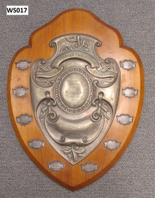
Award - Wooden Shield, 1926
Methodist Children's Choral Festival large varnished wood shield with a smaller metal shield at its centre. The names of the children in the winning choir, Kooyong Road Sunday School Choir, on small metal plates around the border. "METHODIST CHILDREN'S CHORAL FESTIVAL PRESENTATION SHIELD GIFT OF W. SACK ESQ. ST KILDA CIRCUIT 1926" "WON BY KOOYONG ROAD SUNDAY SCHOOL CHOIR MRS E. HOCKING CONDUCTRESS MISS BONNIE B. HOCKING PIANIST"methodist children's choral festival, kooyong road methodist sunday school -
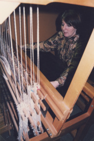 Lakes Entrance Historical Society
Photograph - Woodsedge Gallery, Lakes Post Newspaper, 1999
Marian Edwards weaving at Woodsedge Gallery Baades Road Lakes Entrance Victoria. Also 04075.1 size 9 x 11.5 Black and white photograph of textile exhibition at Woodsedge GalleryColour photograph of Marian Edwards weaving at Woodsedge Gallery Baades Road Lakes Entrance Victoria. Also 04075.1 size 9 x 11.5 Black and white photograph of textile exhibition at Woodsedge Galleryarts, people, arts and crafts, business -
Whitehorse Historical Society Inc.
Article, Housing 'Monster' surprise, 2015
Whitehorse Council voted to approve a 118-dwelling development by Australia Hua Cheng Pty Ltd, Blackburn.Whitehorse Council voted to approve a 118-dwelling development by Australia Hua Cheng Pty Ltd, Blackburn, on the corner of Middleborough Road made up of two five-storey buildings and 15 double-storey buildings on the 7421 sm site.Whitehorse Council voted to approve a 118-dwelling development by Australia Hua Cheng Pty Ltd, Blackburn. city of whitehorse, massoud, denise, australia hua cheng pty ltd -
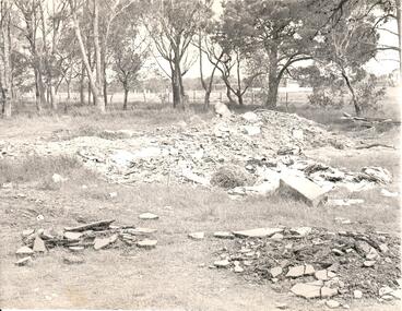 Hume City Civic Collection
Photograph, late 1960s
In the late 1960s St. Mary's Anglican Church was dismantled from its Oaklands Road site and rebuilt on land in Bulla township adjacent to the old shire offices. It was moved because of the interference it would create for aircraft landing in the new Melbourne Airport at Tullamarine. The site has been left timbered because some of the district's early settlers were buried in the church yard before the Bulla Cemetery was established.A black and white photograph of the site of the former St. Mary's Anglican Church at Oaklands Road. There are heaps of building rubble in the foreground and trees in the background.st. mary's anglican church - bulla, oaklands road, graveyards, george evans collection -
Bendigo Historical Society Inc.
Document - Former Conrad Heinze Butcher's Shop, 1872
Source National Trust: Conrad Heinz Butchers Shop - Happy Valley Road. This building was a weatherboard cottage evidently built in three stages with the front door in the central part, planked by three paned double casements, six-paned sash windows in the rear section; front section and timber veradah with scrolled vallance. The architect and builders are unknown. The outside doors to the cellar and the simple chimney breast remain a notable feature. The original owner was Conrad Heinz a former mayor of Bendigo who with two brothers opened a butcher's shop in the building in 1872. In 1883 he moved to Mt Korong Road Iron Bark, where he carried on another thriving business and built a substantial house close by. When Conrad Heinz left Happy Valley Road, one brother had died, but his widow carried on the first butchering business with the help of a lad and one of her three daughters. The little shop and residence stood for over a century on the spot, almost untouched by modern progress. The shop was closed for 70 years at most. It was demolished about 1982.Data Forms on the house on Corner of Happy Valley Road and Wells Street, Long Gully, now demolished. Various letters to and between the Bendigo Council, the National Trust and the owners of the house.history, national trust bendigo collection, bendigo, happy valley road long gully, butcher's shop bendigo, conrad heinze -
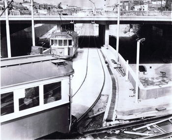 St Kilda Historical Society
Photograph, Wellington St bypass, c. 1968
picture shows ramp from St Kilda Road to by-pass road filed 22.10.68black and white photographAge photo V18369 (titled 22.10.68). Trams using Wellington St by-pass for first time. Picture shows ramp from St Kilda Rd to by-pass road. Copyright. This photo may not be reproduced without permission in writing from the editorof "The Age". 250 Spencer Street, Melbourne and 39/41 York Street, Sydney. -
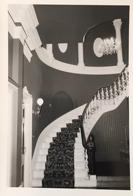 Kew Historical Society Inc
Photograph - 'Butleigh Wooton', 867 Glenferrie Road, John T Collins, 1979
in 1882 Thomas Maidment paid the Society of Jesus £5,750 for nine allotments along Barkly Road (now Glenferrie Road). Maidment, who had arrived in Australia from the Glastonbury district in England in 1858, owned and managed a number of sheep stations in Victoria and subsequently became an '... eminently respectable ...' member of District society. In 1883 the Rate Books list Maidment's land in Barkly Road as the 'Buxton Hill Estate' and it was given an N.A.V. of £90, while in the following year his property attracted an N.A.V. of £160, suggesting that substantial improvements were taking place. Maidment's two-storey mansion, named 'Butleigh Wooton' after his birth-place in England, was completed in 1885 and was given an initial N.A.V. of £420. While Maidrnent is recorded as the owner of the building until at least 1896, Jane Maidment, his wife, continued the family ownership of the twenty-six roomed house with its extensive grounds until at least 1910. (Sanderson P. City of Kew Urban Conservation Study Vol 2)Butleigh Wooton is a substantial two storeyed house built in the Italianate style common in the 1880s. Its walls are rendered and it has limited applied decoration that includes brackets to the eaves line and engaged ionic columns under a broken pediment over the front entrance. The bowed window unit is of particular distinction and is not at all typical of this type of building. This interior by John T Collins is a view of the staircase from the first floor landing. (Sanderson P. City of Kew Urban Conservation Study Vol 2)Reverse: "JOHN COLLINS / 11 Anderson Road / Hawthorn East, 3123 / Film 395 Exposure 21A / Kew / Butleigh Wooton / Staircase / 8-4-79thomas maidment, butleigh wooton, 867 glenferrie road -- kew (vic.), john t collins -
 Kew Historical Society Inc
Photograph - 'Butleigh Wooton', 867 Glenferrie Road, John T Collins, 1979
in 1882 Thomas Maidment paid the Society of Jesus £5,750 for nine allotments along Barkly Road (now Glenferrie Road). Maidment, who had arrived in Australia from the Glastonbury district in England in 1858, owned and managed a number of sheep stations in Victoria and subsequently became an '... eminently respectable ...' member of District society. In 1883 the Rate Books list Maidment's land in Barkly Road as the 'Buxton Hill Estate' and it was given an N.A.V. of £90, while in the following year his property attracted an N.A.V. of £160, suggesting that substantial improvements were taking place. Maidment's two-storey mansion, named 'Butleigh Wooton' after his birth-place in England, was completed in 1885 and was given an initial N.A.V. of £420. While Maidrnent is recorded as the owner of the building until at least 1896, Jane Maidment, his wife, continued the family ownership of the twenty-six roomed house with its extensive grounds until at least 1910. (Sanderson P. City of Kew Urban Conservation Study Vol 2)Butleigh Wooton is a substantial two storeyed house built in the Italianate style common in the 1880s. Its walls are rendered and it has limited applied decoration that includes brackets to the eaves line and engaged ionic columns under a broken pediment over the front entrance. The bowed window unit is of particular distinction and is not at all typical of this type of building. This interior by John T Collins is a view of the staircase from the first floor landing. (Sanderson P. City of Kew Urban Conservation Study Vol 2)Reverse: "JOHN COLLINS / 11 Anderson Road / Hawthorn East, 3123 / Film 395 Exposure 21A / Kew / Butleigh Wooton / Entrance / 8-4-79thomas maidment, butleigh wooton, 867 glenferrie road -- kew (vic.), john t collins -
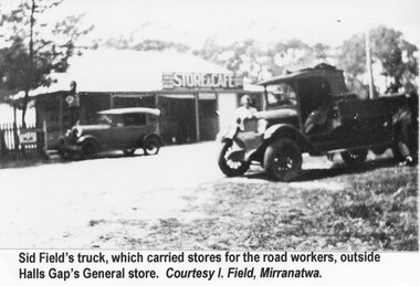 Halls Gap & Grampians Historical Society
Photograph - B/W, C 1930s
Sid Field's truck outside Halls Gap General Store on his trip to pick up stores for the road workers.The photo shows a small truck with a man standing beside it. In the background is the Halls Gap Store with a car parked in front of it."Sid Field's truck, which carried stores for the road workers, outside Halls Gap General store. Courtesy I. Field, Mirranatwa." Typed on a sheet of paper and attached so that it shows beneath the photo.buildings, shops, transport, trucks -
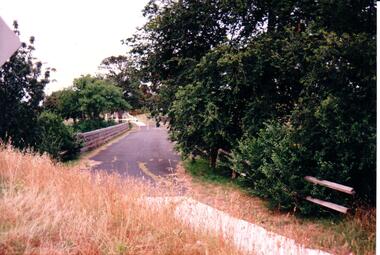 Hume City Civic Collection
Photograph, c 1980s
The stone bridge was the only entry into Sunbury on the eastern side of the town and was in use until the road was re-routed and widened in the 1970s.A coloured photograph of the roadway over the Macedon Street bridge which spans Jacksons Creek. There is a grassy area in the foreground with trees growing either side of the bridge. The narrow asphalted surface of the road across the bridge is cut off by a low stone wall.stone bridges, jacksons creek, macedon street road bridge, george evans collection -
City of Moorabbin Historical Society (Operating the Box Cottage Museum)
Book - A Journey of Faith - The Stained Glass Windows of St Paul's Bentleigh Holy Trinity Parish, by Patrick Ferry, 2015
St Paul's Church is in Jasper Road, Benlteigh. A foundation stone reads " This stone symbol of Christ, Chief corner stone of the church was blessed and set by His Grace Archbishop Simonds 13th November 1960, T O'Sullivan P.P. S. J. Morgan and Associates Architect H.P. Yunken Pty Ltd Builder". The stained glass windows were commissioned by Father Timothy O'Sullivan and the artist was Alan Sumner. The window were progressively installed from 1961, and took nearly 20 years to complete.St Paul's Catholic Church Bentleigh was integral to the spiritual well being and social life of the early settlers.A book about the stained glass windows in St Paul's Catholic Church in Jasper Road, Bentleigh - containing photos and diagram.city of moorabbin, county of bourke, shire of moorabbin, market gardeners, nepean highway, st paul's catholic church, bentleigh, jasper road, religion -
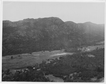 Halls Gap & Grampians Historical Society
Photograph
Photo depicts Fyans Valley. The road is The Grampians/ Dunkeld Road, leading to Dunkeld towards the right or Halls Gap travelling towards the left. Fyans Creek is visible in parts at the foot of the range (middle of Photo). Photo appears to have been taken from Bellfield Pk area. Photo is typical of those taken by Forests Commission of Victoria in the 1960sPhoto shows a mountain range in the background with a valley. The Valley has a band of a mostly cleared grassy section (middle of photo) with a fairly dense treed area in the foreground. A road and some buildings can be seen where the cleared land meets the treed area.scenery, fyans valley -
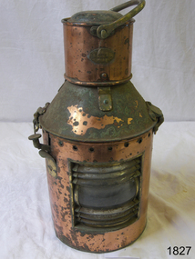 Flagstaff Hill Maritime Museum and Village
Functional object - Marine Lamp, R C Murray & Co Ltd, 1900 -1930
The item is a kerosene marine ships lamp used onboard ships and smaller vessels for general lighting and navigation the subject lamp was made by a very well known maker R C Murray of Glasgow Scotland. During the research several different addresses were found but nothing on the founder or company history. It appears RC Murray made not only marine lamps but lamps for the railways as well. The company is listed in the Scottish Post Office Directories for 1885 to 1886 as manufacturing tinsmiths, lamp makers, coppersmiths, gas fitters, bell hangers and workers in sheet iron, zinc and brass at street numbers 7, 9 and 11 Carlton Court, Bridge St Glasgow. An additional address is at 37 Cavendish St Glasgow listed for 1910, and also at Pollokshaws Road. The writer assumes the company must have moved sometime between 1886 & 1910 to these addresses. The writer at this time cannot ascertain any more historical information regarding the company or its founder, however, lamps made by RC Murray are now collector's items commanding significant sale prices on many auction websites.A significant item used in the marine industry on many ships, the company made kerosene lamps for other industries as well and was a well-known company in the early part of the 20th century.Marine kerosene ships lamp, round copper handle on top and side top is hinged with catch and lever, protruding near top.Inscribed "RC Murray and Co Limited" "Pollokshaws Road Glasgow S.1." flagstaff hill, warrnambool, shipwrecked-coast, flagstaff-hill, flagstaff-hill-maritime-museum, maritime-museum, shipwreck-coast, flagstaff-hill-maritime-village, lamp, lantern, brass lamp, nautical object -
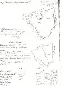 Whitehorse Historical Society Inc.
Legal record - Land Title, Crown grant, 1858
Commercial Bank of Australia record of Crown Grants of land to Nelson Polak and Louis Laurence Smith in 1858.Commercial Bank of Australia record of Crown Grants of land to Nelson Polak and Louis Laurence Smith in 1858. The land is between Canterbury Road, Heatherdale Road, 'Scoresby Road' (now Boronia Road) and the Dandenong Creek.Commercial Bank of Australia record of Crown Grants of land to Nelson Polak and Louis Laurence Smith in 1858. polak, nelson, smith, l l dr, canterbury road, vermont, boronia road, dandenong creek, heatherdale road, land sales -
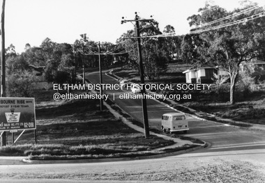 Eltham District Historical Society Inc
Photograph, R.J. Manuell, Sherbourne Rise, Briar Hill, c.1964
... roads ...Sherbourne Rise Estate, looking up Woodland Grove from Calrossie Avenue, Briar Hill. The house is believed to be No. 8. This is prior to Regal Court being established off Woodland Grove. View of Squires land which was subdivided for housing - two parts Woodland Crest higher part off Woodland Grove and Calrossi Avenue, Briar Hill showing new roads with curb and channelling and footpaths. No date.Black and white photograph printed with white bordersVerso: COO2briar hill, real estate, woodland grove, squires, roads, sherbourne rise estate -
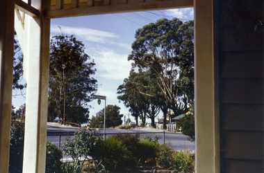
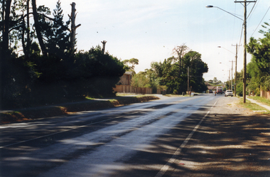 Whitehorse Historical Society Inc.
Photograph, Mitcham Road Prior to Widening, 1/02/2000 12:00:00 AM
Coloured photograph of Mitcham Road looking towards Park Road, Donvale. Taken from Freeway Reservation prior to construction to widen Mitcham Road.mitcham road, donvale, park road -
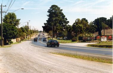 Whitehorse Historical Society Inc.
Photograph, Prior to Widening of Mitcham Road, 1/02/2000 12:00:00 AM
Coloured photograph of Mitcham Road looking towards Springvale Road Junction. Donvale Nursery on right. Taken prior to construction to widen Mitcham Road.mitcham road, donvale, springvale road -
 Whitehorse Historical Society Inc.
Photograph, Vermont Intersection, 1967, C.1967
Part of Tim Shambrook's Collection for 'This is Vermont'. Not used.Coloured photo of Corner of Boronia Road & Canterbury Road, Vermont, taken from Porch of Vermont State School on corner of Mitcham Road in 1967.vermont state school, no. 1022, boronia road, vermont, canterbury road, mitcham road, shambrook, tim -
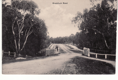 Whitehorse Historical Society Inc.
Postcard - Black and white postcard, Blackburn Road Bridge in Blackburn. Circa 1908, C.1914
Black and white postcard of Blackburn Road at Gardiner's Creek bridge looking south featuring Bridge over unmade road. Entitled 'Blackburn Road'hooke, janet emily, albert arthur, blackburn road, blackburn