Showing 10464 items
matching plan
-
 Bendigo Historical Society Inc.
Plan - MARKS COLLECTION: PLAN OF G. LANSELL'S GOVERNOR'S PARK, TOORAK
Plan (tightly rolled) drawn on heavy paper mounted on fabric. On top of plan printed 'Governor's Park Toorak, late Vice-Regal Estate, the property of G. Lansell Esq' On top of plan Yarra Yarra River, on bottom Toorak Road, Plan shows subdivision, in centre of which is drawn outline of 8 acres containing the 'Mansion and Grounds'.bendigo, hospital -
University of Melbourne, Burnley Campus Archives
Plan - Photocopy, Keilor Planning Scheme, 1993
Photocopies. 18.02.1993. (1) 5 copies Map user guide - Keilor Planning Scheme, List of Zones Reservations and additional Planning Controls. (2) Keilor Planning Scheme - Local Section. Zones and Reserved Land Map No. 7. (3) Map No 9. Also 3 photocopies of maps joined together. Used in planning Native Garden Woodland Section.keilor, native garden, reservations -
Bendigo Historical Society Inc.
Plan - MARKS COLLECTION: HARRISON'S QUARTZ PULVERISER PLAN
Sepia coloured heavy paper, plans drawn in black pen. Written on top of plan: Youngman Harrison's Patent, 22 March 1875' Plans contain drawings labelled as copper pages, roller, grating, drag. Plan has been tightly rolled. On outer edge, written in black pen Harrison Quartz Tailings Pulveriser (last word unclear)equipment, quartz tailing pulverisor, gold mining, lansell -
Whitehorse Historical Society Inc.
Article, Council updating City records, 1993
City of Nunawading is updating its records and introducing a new high-tech computer system.City of Nunawading is updating its records and introducing a new high-tech computer system. The updating co-insides with the planned introduction of Freedom of information to local government from January 1994.City of Nunawading is updating its records and introducing a new high-tech computer system. local government, city of nunawading, miriams, stephanie, bridges, mike -
 Whitehorse Historical Society Inc.
Letter - Correspondence, Schwerkolt Cottage and Orchard site, 14/11/2006 12:00:00 AM
Letter from Heritage Victoria to Mark Fawcett, City of Whitehorse, 16 November 2006 .Letter from Heritage Victoria to Mark Fawcett, City of Whitehorse, 16 November 2006 . Re. inclusion of Schwerkolt Cottage and orchard site in the Victorian Heritage Inventory, with plan and aerial photographLetter from Heritage Victoria to Mark Fawcett, City of Whitehorse, 16 November 2006 . fawcett, mark, schwerkolt cottage & museum complex, historic sites -
Bendigo Historical Society Inc.
Plan - MARKS COLLECTION: EAST WINDMILL HILL CO LEASE PLAN
Plan on heavy paper. On top of plan ' East Windmill Hill Coy's Lease, scale one inch to one chain' Signed in ink by Thomas McNulty (?) Mining Engineer. On RH side of plan written 'Main road from Sandhurst to Eaglehawk'.bendigo, mining, east windmill hill lease co -
University of Melbourne, Burnley Campus Archives
Work on paper (item) - Student Work, Anne Austin, Jeffrey Street Design Brief, December 2013
Created as an assignment for HORT90035, 'Landscape Construction and Graphics,' a subject at Burnley Horticultural College coordinated by Andrew Laidlaw. Only the design brief is present however and the other components like the masterplan, documentation plan and site analysis are all missing. assignment, landscaping, burnley, burnley horticultural college, landscape construction and graphics, hort90035 -
 Federation University Historical Collection
Book - Annual Report 1880, The School of Mines Ballaarat Annual Report, 9 February, 1880, 1880
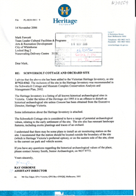
The School of Mines Annual Report, 9 February, 1881, Additional Examination Statute 1880, Balance Sheet, Certificates Granted by Council, Donations and Fees - carriage of, Extracts from Visitors' Book, Fees, Form of Bequest, Honorary Correspondents, Life Governors, Mining and Mineral Contributions Invited - Paper of Particulars, Museum - open to visitors, Office Bearers, Obituary, Report of the Lecturer in Mathematics, Report of the Lecturer in Mining-Land- and Engineering-Surveying, Report of the Lecturer in Mechanical Engineering, Report of the Lecturer in Telegraphy, Report of the Curator of the Museum (with Plans), Report of the Superintendent of Laboratories, Subjects and Lecturers, Subjects and Examiners, Statement of Receipts and Expenditure for the year 1880, Subscriptions and Donations from 1 January to 31 December 1880, The Lal-Lal Iron Ore Deposits - (with Section and Plan)Pale green booklet of 70 pages, Annual Report 1880. Image of Guage Test Tower, Image of The School of Mines, Plan of Ground and Buildings - Albert Street, The School of Mines Ballaarat - The Museum - Plan of Groundfloor, Image of the Lal-Lal Iron Ore Deposits, Moorabool Riverthe school of mines, annual report, additional examination statute 1880, balance sheet, certificates granted by council, donations and fees - carriage of, extracts from visitors' book, fees, form of bequest, honorary correspondents, life governors, mining and mineral contributions invited-paper of particulars, museum open to visitors, office bearers, obituary, report of the lecturer in mathematics, report of the lecturer in mining-land and engineering-surveying, report of the lecturer in mechanical engineering, report of the lecturer in telegraphy, report of the curator of the museum (with plans), report of the superintendent of laboratories, subjects and lecturers, subjects and examiners, statement of receipts and expenditure for the year 1880, subscriptions and donations from 1 january to 31 december 1880, the lal-lal iron ore deposits-(with section and plan), obituary - sir redmond barry - arthur leahy - jacob upfold - john day, mr james oddie, dr. r. f. hudson, john victor, chas. wm. thomas, w. h. shaw, walter d. campbell, ferdinand m. krause, joseph flude, geo. perry, w. hy. barnard, examination statute, his excellency sir wm. f. drummond jervois, charles h. pearson, t. brodribb, professor pepper, james mitchell, robert adam, wm. lant carperter, h. b. de la poer wall, w. h. brokenshire, arthur parker, henry parkinson, c. davies, simon richards, c. v. gorton, c. r. blackett, david jones, wilberforce dyke, ferdinand krause, ballarat school of mines museum, ballarat school of mines museum plan, lal lal ore deposits, moorabool river, william land carpenter, william jervois, william henry tbarnard -
Port Melbourne Historical & Preservation Society
Plan - Metalling and channelling Unnamed Street from Esplanade West to Esplanade East, Engineering Department, Town of Port Melbourne, Mar 1893
Plan for metalling and channelling unnamed street from Esplanade West to Esplanade East Loan Works 1893 plan 19; relates to specification 100.1Signed by JJ Bartlett (Mayor) 14.3.1893engineering - roads streets lanes and footpaths, town planning, town clerks, mayors, arthur victor heath, james john bartlett -
Port Melbourne Historical & Preservation Society
Plan - Tide limits at Inner East berth Station Pier for Tasmanian ferry Abel Tasman, Engineering Division, Port of Melbourne Authority, 1984
Plan: Tasmanian ferry at Inner East Station Pier - tide limits at working draft (highest tide). This plan relates to the vessel Abel Tasmanmelbourne harbor trust - port of melbourne authority, piers and wharves - station pier, abel tasman -
Port Melbourne Historical & Preservation Society
Plan - Tide limits at Inner East berth Station Pier for Tasmanian ferry Abel Tasman, Engineering Division, Port of Melbourne Authority, 1984
Plan: Tasmanian ferry at Inner East Station Pier - tide limits at working draft (lowest tide). This plan relates to the vessel Abel Tasmanmelbourne harbor trust - port of melbourne authority, piers and wharves - station pier, abel tasman -
Port Melbourne Historical & Preservation Society
Plan - Coal tramway, Town Pier to Gas Works via Esplanade West, 1880s
From set of three photocopies of two plans of coal tramway, Town Pier to Gas Works via Esplanade West: Plan of coal tramwaytransport - tramways, utilities - gas, sandridge lagoon, industry - manufacturing, piers and wharves - town pier, metropolitan gas company, australasia sugar refining company, robert harper & co ltd -
 Kew Historical Society Inc
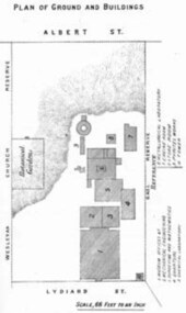
Plan - Subdivision Plan, Charteris Estate, East Ivanhoe, 1939
The Charteris Estate in Ivanhoe was sold in a number of sections. Copies of a subdivision plan of the first section is in the State Library of Victoria collection. This later section of the Charteris Estate includes lots in the Government Boulevard, Castella Street, McArthur Road, Burke Road North, Charteris Drive and Warncliff Road.Subdivision plans like that for the Charteris Estate are invaluable records for local historians identifying when lots in streets were promoted for sale.Four-fold brochure advertising the Charteris Estate in East Ivanhoe in 1939. Streets named on the plan include: the Government Boulevard, Castella Street, McArthur Road, Burke Road North, Charteris Drive and Warncliff Road. The brochure contains photos of Charterisville, the home of F De Castella Esq and also of attractive rolling hills. Annotations in pencilcharteris estate - east ivanhoe (vic), subdivision plans - east ivanhoe (vic) -
 Kew Historical Society Inc
Plan - Subdivision Plan, Charteris Estate, East Ivanhoe, 1939
The Charteris Estate in Ivanhoe was sold in a number of sections. Copies of a subdivision plan of the first section is in the State Library of Victoria collection. This later section of the Charteris Estate includes lots in the Government Boulevard, Castella Street, McArthur Road, Burke Road North, Charteris Drive and Warncliff Road.Subdivision plans like that for the Charteris Estate are invaluable records for local historians identifying when lots in streets were promoted for sale.Four-fold brochure advertising the Charteris Estate in East Ivanhoe in 1939. Streets named on the plan include: the Government Boulevard, Castella Street, McArthur Road, Burke Road North, Charteris Drive and Warncliff Road. The brochure contains photos of Charterisville, the home of F De Castella Esq and also of attractive rolling hills. Annotations in pencilcharteris estate - east ivanhoe (vic), subdivision plans - east ivanhoe (vic) -
 Warrnambool and District Historical Society Inc.
Documents, Late 20th, early 21st centuries
These ten documents (maps, plans, photographs) mostly come from the Warrnambool City Council and most contain information on sub-divisions and titles of properties in areas around the Central Business District of Warrnambool. The dates range from 1986 to 2006. These maps, plans and photographs are of some interest as they give historical details of subdivisions in Warrnambool and date from the late 20th century. .1 This is a laminated map of the boundaries of Local Governments in Victoria. It is Sheet I of 2 and has red and blue pencil markings and black boundary markings. .2 This is a copy of a plan of a survey in black and white markings on paper. .3 This is a plan of the title details of Section 19 Warrnambool. It has black printing on buff-coloured paper. .4 This is a plan of the allotments in part of the Central Business District of Warrnambool. It is printed in black and white. .5 This is a 2006 coloured aerial photograph of the harbour at Warrnambool – Breakwater etc. .6 This is a 2006 coloured aerial photograph of the Lake Pertobe area in Warrnambool .7 This is a coloured aerial photograph of Warrnambool’s streets over-stamped with road numbers in large blockings. .8 This is a plan showing the title details of Section 11 in Warrnambool. It has black printing on buff-coloured paper. .9.1 This is a plan of sub-divisions in parts of Crown Allotments 38 & 39 in Warrnambool. It has green, pink and yellow markings with black printing. .9.2 This is a plan of the sub-divisions in parts of Allotments 38 & 39 in Warrnambool. It has pink, yellow and blue markings with black printing. It is somewhat faded. warrnambool c.b.d. maps and plans, history of warrnambool -
Clunes Museum
Plan - CONCEPT DRAWINGS/PLANS, JOHN ALKEMADE & ASSOC, CLUNES COMMUNITY AND INTERPRETIVE CENTRE, 2012
CONCEPT DRAWINGS BY 3 ARCHITECTS AND EXPLANATORY INFORMATION. ALL LAMINATED ARCHITECT JOHN ALKEMADE & ASSOC. .1 PROPOSED FLOOR PLAN .2 SITE PLAN - PHOTOCOPY OF 1 AND 3 .3 SOUTH EAST VIEW ARCHITECT R. BRAMELL 2006 .4 LONGITUDINAL SECTION .5 FLOOR PLAN .6 FACADE ARCHITECT MORTON DUNN 2012 .7 GROUND FLOOR PLAN .8 SITE PLAN .9 FIRST FLOOR PLAN 10 CONCEPT DRAWING OF OUTCOME .11 WHAT IS THE CCIC .12 COMMUNITY REFERENCE GROUP .13 THE BUDGET .14 PROJECTED TIMELINE clunes community and interpretive centre concept, william barkell -
Whitehorse Historical Society Inc.
Article, Many Questions on Land, 1/09/2014 12:00:00 AM
The Victorian State Governme.nt will protect 2 parcels of land totalling 15.4 ha. of the Healesville Freeway Reservation as Crown Land.The Victorian State Government will protect 2 parcels of land totalling 15.4 ha. of the Healesville Freeway Reservation as Crown Land and the planned walking and cycling path, running it's entire length, will go ahead.The Victorian State Governme.nt will protect 2 parcels of land totalling 15.4 ha. of the Healesville Freeway Reservation as Crown Land.healesville freeway reservation, cycling path, walkinig path -
 Kew Historical Society Inc
Plan - Subdivision Plan, Oswinia Estate, East Kew, c.1925
Prue Sanderson, in her groundbreaking ‘City of Kew Urban Conservation Study : Volume 2 - Development History’ (1988), summarised the periods of urban development and subdivisions of land in Kew. The periods that she identified included 1845-1880, 1880-1893, 1893-1921, 1921-1933, 1933-1943, and Post-War Development. These periods were selected as they represented periods of rapid growth or decline in urban development. An obvious starting point for Sanderson’s groupings involved population growth and the associated economic cycles. These cycles also highlighted urban expansion onto land that was predominantly rural, although in other cases it represented the decline and breakup of large estates. A number of the plans in the Kew Historical Society’s collection can also be found in other collections, such as those of the State Library of Victoria and the Boroondara Library Service. A number are however unique to the collection.Subdivision plans are historically important documents used as evidence of the growth of suburbs in Australia. They frequently provide information about when the land was sold on which a built structure was subsequently constructed as well as evidence relating to surveyors and real estate and financial agents. The numerous subdivision plans in the Kew Historical Society's collection represent working documents, ranging from the initial sketches made in planning a subdivision to printed plans on which auctioneers or agents listed the prices for which individual lots were sold. In a number of cases, the reverse of a subdivision plan in the collection includes a photograph of a house that was also for sale by the agent. These photographs provide significant heritage information relating house design and decoration, fencing and household gardens.The ‘Oswinia Estate’ subdivision in East Kew was planned and auctioned in the first half of the 1920s. 169 allotments were created in the triangular section of land bordered by High Street, Burke Road and the Government Boulevard (later Kilby Road). The only piece of land excluded was that where the previous Kew Pound had been located at the east tip of the triangle. Allotments were created fronting Glass, High, Namur, Oswin Streets, Irymple Avenue, and the Government Boulevard. The name for the Estate was derived from Oswin’s farm, which had been one of the largest landholdings in East Kew. The selling agents annotated the plan in our collection with crosses indicating those lots that had been sold. The inset locality plan is particularly interesting as it shows the route and stations of the Outer Circle Railway. When the subdivision plan was created, it included the proposed bridge over the Yarra at Burke Road. The bridge was to be officially opened in 1926.subdivision plans - east kew, oswinia estate, high street, glass street, namur street, government boulevard - kilby road, irymple street, oswin street -
 Federation University Historical Collection
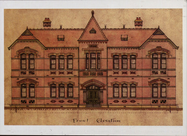
Plan - Postcard, Front Elevation of the Ballarat School of Mines New Classrooms (now Administration Building), 1898, 16/02/1899
In 1900 this building was described as 'handsome in design, well lit, well ventilated, commodious - containing Council room, office, chemical laboratory, mineralogical laboratory, students room and six lecture rooms. Postcard of the original hand coloured plan on linen of the Ballarat School of Mines New Classrooms (from 2014 known as the Federation University Australia SMB campus Administration Building). The plan shows the front elevation, section on line, ground and 1st floor plan. ballarat school of mines, new classrooms, administration building, architectural plans -
Whitehorse Historical Society Inc.
Document, Mitcham Shopping Centre redevelopment, 1960s-1970s
Collection of papers relating to the Mitcham Chamber of Commerce proposal for redevelopment of Mitcham Shopping Centre.Collection of papers relating to the Mitcham Chamber of Commerce proposal for redevelopment of Mitcham Shopping Centre, in particular, parking, and reconstruction of Whitehorse Road by the Country Roads Board. Incl. correspondence, plans, news cuttings.Collection of papers relating to the Mitcham Chamber of Commerce proposal for redevelopment of Mitcham Shopping Centre.mitcham shopping centre, whitehorse road, mitcham, mitcham chamber of commerce, armstrong, raleigh edward, car parks, victoria. country roads board -
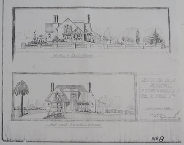 Federation University Historical Collection
Plan - Plan (copy), 'Design for Brick Residence Cnr Sturt and Russell St for K. Price Esq.' by Herbert C. Coburn, not dated
Ballarat born Herbert L. Coburn grew up to be a renowned Ballarat architect, practising from 1905 to 1956. He taught Architecture and Building Construction at the Ballarat School of Mines (SMB) from 1918, resigning in 1948 due to ill health.Photocopy of a plan by architect H. L. Coburnherbert l. coburn, coburn, h.l. coburn, k. price, architectural plan, russell street, ballarat -
Port Melbourne Historical & Preservation Society
Plan - Housing Commission, Crockford Street, Ingles Street and Raglan Street, Port Melbourne, 1950s
Plan of area Crockford, Ingles and Raglan StreetsHousing Commissionbuilt environment - industrial, w a pentland, sue pentland -
Port Melbourne Historical & Preservation Society
Plan - Bathing Dressing Shelter, Port Melbourne, Engineering Department, City of Port Melbourne, 22 Sep 1911
Plan for simple dressing shelter for bathing, 1911.Signed by Joseph Fisher 22-9-1911 and A. V. Heath 28-9-1911built environment - recreational facilities, sport - swimming, arthur victor heath, town clerks, joseph fisher -
Port Melbourne Historical & Preservation Society
Plan - Extension to weighbridge, Sandridge, George Kelly?, Borough Surveyor, 8 Nov 1864
Plan for extension of weighbridge, Borough of Sandridge, 1864.Numbered in red pencilengineering, engineering department - borough of sandridge, george kelly -
Port Melbourne Historical & Preservation Society
Plan - Port Melbourne Town Hall, c. 1915
Plan of 'New Town Hall' i.e. 1915Tiny calculations in pencil, bottom centre and right; contract no. (no signatures)port melbourne town hall -
Port Melbourne Historical & Preservation Society
Plan - Raglan Street, Port Melbourne, Borough of Sandridge, 1890s
Plan of Raglan Street showing longitudinal section.Chas Clay (Borough Surveyor):E. Clark (Town Clerk):John Clang (Contractor ?)raglan street, engineering - roads streets lanes and footpaths, town clerks, charles clay, edward clark -
Port Melbourne Historical & Preservation Society
Plan - Sandridge Township, 1860, 1860
On back is handwritten - Nov 1860.Plan of Sandridge Township 1860 (Latrobe Library)Nov. 1860 (on rear)local government - municipal district of sandridge -
Clunes Museum
Plan - ARCHITECTS PLANS, DARYL JACKSON REPORT PTY. LTD. 35 LITTLE BOURKE , MELBOURNE
SKETCH DESIGN REPORT - WESLEY AT CLUNESARCHITECTS PLAN WESLEY AT CLUNES. DARYL JACKSONlocal history, document, plans, education, schools, wesley -
University of Melbourne, Burnley Campus Archives
Plan, Classroom Locations Map, 1990-2000
Plan produced by VCAH Burnley with classrooms marked.vcah, burnley -
 University of Melbourne, Burnley Campus Archives
Plan, Nursery
nursery