Showing 4082 items matching " surveys"
-
 Bendigo Military Museum
Map - Map Extract - Charterhouse of Mendip, John James Raisbeck, Unknown
Map extract showing the towns of Cheddar, Rodney Stoke, Westbury and a smaller town of Easton. The area depicted is part of Somerset, England. Map is hand drawn by J.J. Raisbeck date unknown. John James RAISBECK was born on 4 July 1880 at Christchurch New Zealand. He served 4 years (Citizen Military Force - CMF) in 9th Australian Light Horse Regiment in Central VIC with the rank 2nd Lieutenant. He was the first Australian appointed to the Survey Section RAE, on 16 April 1910, as a draughtsman which was his civilian profession, with the rank Warrant Officer, honorary 2nd Lieutenant. He was required to resign his commission in the CMF. He supervised the draughting work of the Section in Melbourne and was largely responsible for the mapping standards and specifications set in the production of the Cowes one-inch-to-one-mile military map, which became the enduring Australian standard. He was also responsible for supervising the printing of the maps by the Victorian Government Printer. He was appointed 2nd Lieutenant in the AIF Survey Corps draft on 6 December 1917 (from Melbourne) embarking for England on 22 December 17. He was attached to the Australian Corps Topographic Section in France from 21 April 1918 to 5 March 1919 serving as Second-in-Command and as Officer Commanding. He was promoted Lieutenant 15 October 1918, attending the AIF Survey School, Southampton in 1919, returning to Australia 23 June 1919, before his AIF appointment was terminated 17 July 1919. He went on to serve the Survey Section RAE and Australian Survey Corps, including in the Second World War, having been promoted Captain then Major and Officer Commanding Army Headquarters Cartographic Section until February 1940. He retired after 33 years of service to military survey, and after serving the Corps in two world wars, on 4 July 1943 with the retired rank Lieutenant-Colonel. He was the author of the article ‘A Short History of the Military Survey of Australia, 1907-1936’, published in The Australian Surveyor, Sept 1, 1937Map extract slightly larger than A4. Scale: One Inch to One and a half Mile. 1:31680, 9 x copiesSignature of "J.J. Raisbeck" bottom right-hand cornerroyal australian survey corps, rasvy, fortuna, army survey regiment, army svy regt, asr -
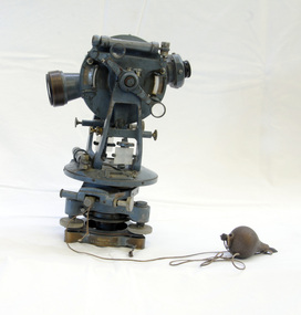 Orbost & District Historical Society
theodolite, first half 20th century
Theodolites have been used to measure horizontal and vertical angles by surveyors since the 1500s. A theodolite is a precision instrument for measuring angles in the horizontal and vertical planes. Theodolites are used mainly for surveying applications, and have been adapted for specialized purposes in fields like meteorology and rocket launch technology. Theodolites, such as this one, were instrumental to early surveyors, and would have played a significant part in their everyday work. The plumb bob was used to set the instrument exactly over a fixed survey marker.This theodolite was made by Troughton and Simms, who were significant scientific instrument makers of the 19th century and early 20th century. In 1782 John Troughton purchased Benjamin Cole's shop in Fleet Street, London enabling him to sell his own signed products. His instrument making business supported several dynasties of Troughtons before becoming Troughton and Simms and later still Cooke Troughton & Simms. This firm was one of the most well respected firms of instrument makers of the 1800s. A grey metal theodolite - probably made of brass. It has movable parts and there is a weight ( a plumb bob) attached with string.Cooke Troughton & Simms Yorke England V012318 Supplied by A. E. Parsons Melbournetheodolite scientific-instruments surveying -
 Bendigo Military Museum
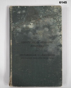
Manual - Mathematical Tables for the Computation of Geographic positions and Rectangular Coordinates, 1942
Numerous mathematical tables for the computation of Geographical Positions and rectangular coordinatesHard covered Book, cloth covered, A5 in size, 169 pages, Title Page, contents Page, 5 x blank pages at front, 15 x blank pages at rear."? Slattery" , "Sgt RC Andrews. School Tac? Adm. Seymour" all crossed out, on 1st page inside cover. "Please Return to: Survey Directorate AHQ Victoria Barracks Melbourne" Front and rear pages.royal australian survey corps, rasvy, fortuna, army survey regiment, army svy regt, asr -
 Federation University Historical Collection
Map, Creswick Gold Field Map, 1981
A fragment of the original 1880 map is also held in the collection. See 116Rectangular geological map with brown paper strip on top edge with 4 holes on top edge. Scale is 40 chains to one inch.Geologically and topographically surveyed by Ferdinand M Krause. Lithographed by R. Shepherd. Printed by J. Finnie. Mining Department, Melbourne. Preprinted with additional shaft and lead detail. F. D. Atkinson, Government Printer 1981creswick, krause, surveyor, smeaton, spring hill, tourello, ascot, dean, bullarook, gold fields, gold -
 Ringwood and District Historical Society
Map - State Aerial Survey, Dandenong Ranges Area, Parishes of Warrandyte and Ringwood - 1956
Map of central and southern areas of Ringwood and part of Ringwood East and Heathmont compiled by Dept of Lands and Survey, July 1956, from aerial photographs and Cadastral Survey information. Subsequent hand-drawn addition of streets showing layout of "Township of Ballyduffy Estate 1858-60", an earlier proposed subdivision that did not eventuate. (See attached 5009b Ballyshanassy_ Melbourne’s lost suburb.pdf for Ballyduffy historical naming relevance). Ballyduffy Estate streets include City Road, West Prussia Road, Duffy Street, Ireland Street, Evans Street, Victoria Street, Regina Street, Short Road, Prussia Road, Duffy Street East, Ireland Street East, Evans Street East, Chapman Street. Misc Topo 93 Sheet 22, Ringwood A4B2. Scale: 4 chains to 1 inch. Contour interval 20 feet. -
Whitehorse Historical Society Inc.
Document, Melbourne and Metropolitan Archaeological survey, 1/03/1982
History of Aboriginal occupation of the Melbourne area. Evidence of shell midden refuse associated with their campsites. Evidence of scarred trees and scatters of stone artefacts along major stream systems. It has been established that man was in the Melbourne area 40,000 years ago and that Aboriginal occupation probably continued uninterrupted throughout the extremes of the last ice age, around 20,000 years ago when Port Phillip itself was dry land. Study will take 2 - 3 years. Aims (1) identify areas of potential archaeological importance (2) implement a pilot survey program (3) prepare comprehensive proposals for survey of sites. (4) liaise and establish rapport with municipal authorities in study area.aborigines, wurundjeri, bunurong, australian heritage commission, victoria. ministry for conservation, victoria archaeological survey -
 Bendigo Military Museum
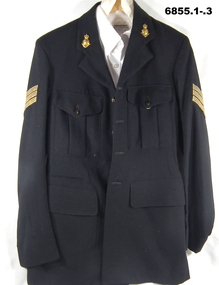
Uniform - MESS DRESS, CGCF, 1960
.1) Black woollen jacket. Gold Sergeants stripes. Survey Regt collar badges. It has 4 brass buttons on front. 4 major pockets on front, the top two are held shut with brass buttons. .2) Trousers black. Red welt down side of legs - width 4 cm. Buttoned fly, black plastic buttons for braces. .3) Shirt - white, long sleeved with 7 pearl like buttons on front. It has a pocket on the left breast. .4) Belt - black wool, brass buckle. .5) Tie - black woollen. .6) Cap - Officers. Black leather peak. Survey regiment badge. Red band around hat..1) Jacket - "A. Skidmore" , “NR possibly 36894”post ww2, army, uniform, suurvey regiment, passchendaele barracks trust -
University of Melbourne, Burnley Campus Archives
Plan, Blessington Street Gardens, 1983-1984
City of St Kilda plans. (1) Existing Conditions: NW Quadrant. Drawing No. 2135 File No 8-134. 1 of 4 Surveyed by Peter Herbert. Scale 1:250. (2) NE Quadrant. Drawing No 2136, 2 of 4. (3) SE Quadrant. Drawing No 2137, 3 of 4. (4) SW Quadrant. Drawing No 2138, 4 of 4. (5) Existing Conditions. Drawing No 2139, 1 of 1. Scale 1:500. (6) Redevelopment - Concept A. Designed by N. Hamey Sept '83 Scale 1:500. Drawing No 2140 1 of 2. (7) Tree Inventory. Surveyed by P. Herbert, traced by Greg Hocking Feb '84. Drawing No 2140, 1 of 2.st kilda, blessington street gardens, peter herbert, greg hocking, trees -
 Bendigo Historical Society Inc.
Map - HUSTLER'S REEF & HUSTLER'S REEF NO 1 MINES - PLAN OF THE HUSTLER'S REEF & HUSTLER'S REEF NO 1 MINES
Plan of the Hustler's Reef & Hustler's Reef No 1 Mines on the Hustler's Line of Reefs, Bendigo Bulletin No 33, Plate No XIV. No 8 connecting No 10 (Hustler's Reef), No 11 connecting No 13 (Hustler's Reef), No 13 (Hustler's Reef No 1) connecting No 15 (Hustler's Reef) and No 10 Hustler's Reef No 1 rise to Comet Mine. Map shows different levels in relation to the two shafts, the lines of the Hustler's Line of Reefs and the Lightning Hill Line of Reefs, the approximate Boundary of Lease and the Comet Co., the adjoining lease. Table on the left shows the levels and their depths of the two mines. Signed by H A Whitelaw, Underground Survey Office, Bendigo, September 1913. Geological Survey of Victoria emblem. mining, parish map, hustler's reef & hustler's reef no 1 mines, hustler's line of reefs lightning hill line of reefs, comet co., h a whitelaw, underground survey office bendigo, geological survey of victoria -
 Orbost & District Historical Society
map/brochure, Discovering Marlo & The Snowy River Estuary, December 1988
In 1983 the Department of Conservation, Forests and Lands replaced the Department of Crown Lands and Survey, the Department of State Forests and the Ministry for Conservation. This brochure/map was used as tourist information in Orbost.This item is a useful research tool.A folded map/brochure titled "DISCOVERING MARLO & THE SNOWY RIVER ESTUARY". On the front is a photograph of Marlo and the title in yellow print. There is a locality map for access to Corringle beach and the brochure Includes a key to fishing sites and various tourist locations. On the back of the brochure are notes on fishing, wildlife and a boating guide, map brochure snowy-river marlo -
 Bendigo Military Museum
Administrative record - I Fd Svy Sqn Monthly Report: Jan - Jun 1979, 1 Fd Svy Sqn, 30 Jun 1979
Report covering the activities of 1 Fd Svy Sqn between Jul 78 to Sep 78. Monthly Reports were mandatory for Royal Australian Survey Corps unitsPlastic, Cardboard covered, A4 Paper reports, diagrams. Loose pages and pictorial Index at rearroyal australian survey corps, rasvy, fortuna, army survey regiment, army svy regt, asr -
 Bendigo Military Museum
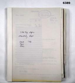
Administrative record - I Fd Svy Sqn Monthly Report: Oct - Dec 1978, 1 Fd Svy Sqn, 1978
Report covering the activities of 1 Fd Svy Sqn between Oct 78 to Dec 78. Monthly Reports were mandatory for Royal Australian Survey Corps unitsPlastic, Cardboard covered, A4 Paper reports, diagrams. Pictorial Index at rear.royal australian survey corps, rasvy, fortuna, army survey regiment, army svy regt, asr -
 Bendigo Military Museum
Administrative record - Army Survey Regiment Officers Mess Ball 1991, Army Survey Regiment, Bendigo, February 1991
The Army Survey Regiment held Annual Balls at Fortuna Villa. This folder contains the documentation for the Logistics and activities associated with the planning and running of the Officers Mess Ball held in 1991.Carboard Folder, blue, containing correspondence, invitations, photos and diagrams.royal australian survey corps, rasvy, fortuna, army survey regiment, army svy regt, asr -
 Bendigo Military Museum
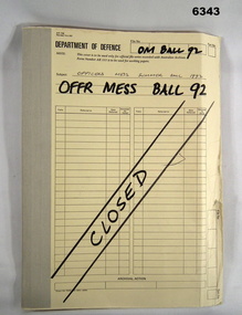
Administrative record - Army Survey Regiment Officers Mess Ball 1992, Army Survey Regiment, Bendigo, 1992
The Army Survey Regiment held Annual Balls at Fortuna Villa. This folder contains the documentation for the Logistics and activities associated with the planning and running of the Officers Mess Ball held in 1992.Correspondence Manilla Folder with cloth binding, Contains correspondence, photographs and diagrams.royal australian survey corps, rasvy, fortuna, army survey regiment, asr -
 Bendigo Military Museum
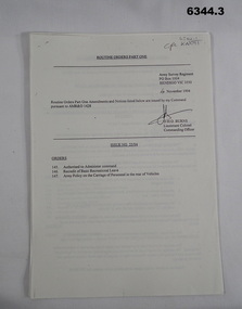
Administrative record - Army Survey Regiment - Routine Orders Part1 1994, Army Survey Regiment, Bendigo, 1, 4 Nov 1994, .2, 16 Nov 1994, .3, 25 Nov 1994
Army Survey Regiment published Unit Administrative Routine Orders regularly. .1 is issue 25/94, .2 is issue 26/94 and .3 is Issue 27/94.1, .2, .3 are all A4 sheets of paper stapled top left royal australian survey corps, rasvy, fortuna, army survey regiment, army svy regt, asr -
 Bendigo Military Museum
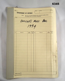
Administrative record - Army Survey Regiment Officers Mess Ball 1994, Army Survey Regiment, Bendigo, February 1994
The Army Survey Regiment held Annual Balls at Fortuna Villa. This folder contains the documentation for the Logistics and activities associated with the planning and running of the Officers Mess Ball held in 1994.Cloth bound manilla Correspondence File containing A4 paper documentsroyal australian survey corps, rasvy, fortuna, army survey regiment, army svy regt, asr -
 Bendigo Military Museum
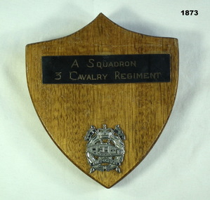
Souvenir - SHIELD 3 CAV, C.1960’s
Item in the collection re Geoff Murray No 3411521, served Vietnam with 3 Cavalry Regt 27.11.1967 to 22.10.1968, Survey Corp 15.10.1969 to 15.10 1970. refer Cat No 638P.Wooden shield shape with metal plaque reading "A Squadron 3 Cavalry Regiment" and that unit's badge in silver coloured metal.military history-regimental shield, 3 cav -
Federation University Historical Collection
Equipment - Scientific Instrument, T. Cooke & Sons Ltd, Theodolite, early 1900s
The theodolite is used in surveying and measures vertical and horizontal angles. Placed on a tripod, it is used to find angles in road building, tunnel alignment and other civil engineering work. The theodoliteTheodolite with four levelling screws. External focusing.ballarat school of mines, surveying, engineering, cooke, theodolite, scientific instrument -
 Federation University Historical Collection
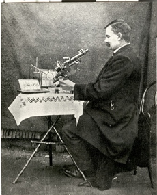
Photograph - Photograph - Black and White, John Brittain
On 28 June 1907 John Brittain, a well known writer and lecturer on astronomical subjects was appointed lecturer and demonstrator in Astronomy in the Department of Engineering and Surveying at the Ballarat School of Mines. A man in a jacket looks toward a microscope on a table with white tablecloth. The man is John Brittain who lectured at the Ballarat School of Mines. ballarat school of mines, scientific equipment, microscope, john brittain, astronomy, astronomical, scientific objects, observatory -
 Bendigo Historical Society Inc.
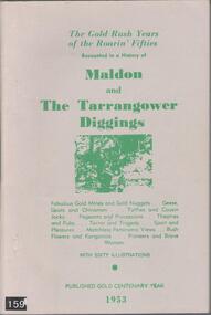
Book - BOOK: THE GOLD RUSH YEARS OF THE ROARIN' FIFTIES - RECOUNTED IN A HISTORY OF MALDON AND THE TARRANGOWER DIGGINGS BY A J WILLIAMS, 1953
Gold on the Tarrengower Diggings was discovered in the early 1850's, with the town of Maldon being surveyed and proclaimed in Dec. 1853. The gold boom continued until the early 1900's.Soft cover book with buff coloured cover with green printing. Contains 88 pages (no index) covering the events leading to the establishment of Maldon in its early years. Contains many black and white photographs. Published by R T Williams Maldon Times Maldon 1953.A J Williamshistory, australian, maldon -
 Linton and District Historical Society Inc
Photograph, Restoration of LDHS Resource Centre, 1987
Christopher Grigg, President of Linton & District Historical Society, surveying the restoration work being done on the LDHS Resource Centre (afterwards called the Letty Armstrong Resource Centre).Black and white photograph showing front of LDHS Resource Centre, taken during its restoration. Truck parked outside, Chris Grigg to left of photograph.linton & district historical society, buildings, ldhs resource centre -
 Bendigo Military Museum
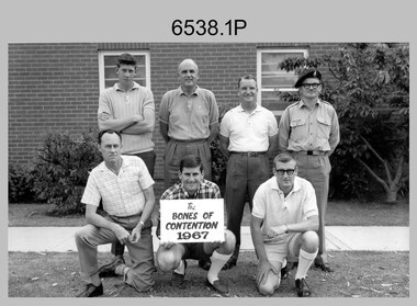
Photograph - Bones Day – Army Survey Regiment Verses RAAF School of Radio at Laverton, Victoria, 1967
These seven photographs were taken at Bones Day, an annual sports competition between the Army Survey Regiment and the RAAF School of Radio at Laverton in 1967. The two units took turns each year to host the event. The day competition usually comprised basketball, cricket, cross country, golf, sailing, squash, softball, tennis, touch football, rifle shooting, tug-of-war and volleyball. The “big bone” trophy comprising a large bone from a beast housed inside a wooden framed glass case, was awarded to the winner of the day competition. The evening competition often included darts, carpet bowls, hookey, quoits and billiards/snooker. The “little bone” (a mounted chicken bone) was the consolation trophy awarded to the winner of the evening competition. The 3-hour bus trip for the visiting unit on their return was typically very raucous. The history of the Bones Day competition is best described in the booklet titled - Bones of Contention Souvenir Program. 1965. Refer to Item 6267.These seven photographs were taken at Bones Day, an annual sports competition between the Army Survey Regiment and the RAAF School of Radio at Laverton in 1967. The photographs were printed on photographic paper and are part of the Army Survey Regiment’s Collection. The black and white photographs were scanned at 300 dpi. .1) - Photo, black & white, 1967, Golf. ASR Team Back row L to R: Graeme Jeffers, CO LTCOL John Nolan, unidentified, Ace Evans. Front row L to R: unidentified (x2), Stan Vote. .2) - Photo, black & white, 1967, ASR Rifle Shooting Team Back row L to R: Ian ‘Lofty’ Turner, unidentified, Daryl Hockings CSM, Geoff Haynes, unidentified (x2). Front row L to R: unidentified (x2), unidentified UK exchange officer. .3) - Photo, black & white, 1967, ASR Tennis Team L to R: unidentified, Kalen Sargeant, unidentified, Marj Knight. .4) - Photo, black & white, 1967, ASR Squash Team – Back row L to R: unidentified (x2), Bob Williams, unidentified. Front row L to R: L.D. Clayden, Loretta Hall. .5) - Photo, black & white, 1967, ASR Cricket Team: Unidentified personnel. .6) - Photo, black & white, 1967, ASR Basketball Team Back row L to R: unidentified (x2), Gordon Lowery. Front row L to R: unidentified, John McCulloch, Ken ‘Sluggo’ Slater. .7) - Photo, black & white, 1967, ASR Tug-of-War Team Back row unidentified (x4), Tom Pattison, unidentified (x2). Front row L to R: unidentified, Ken ‘Sluggo’ Slater, unidentified (x3)..1P to .7P –No personnel are identified.royal australian survey corps, rasvy, army survey regiment, army svy regt, fortuna -
 Ringwood and District Historical Society
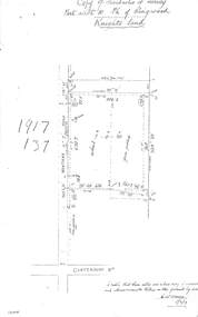
Document - Copy of Lands Department Field Notes - Parish of Ringwood, Victoria, Field Notes 1917/137 - Part of O.P. R72 - Allotment 10, surveyed June 1917
5613b Foolscap size photocopy of survey map with handwritten notations. References include Knight's land, Wantirna Road, Canterbury Road, house, wirenetted, orchard, grass paddock, I certify that these notes are a true copy of observations and measurements taken on the ground by me (signed) H.W. Moore 5/6/17. -
 Ringwood and District Historical Society
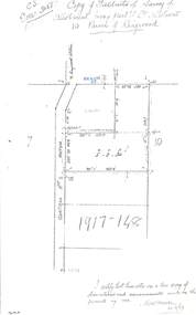
Document - Copy of Lands Department Field Notes - Parish of Ringwood, Victoria, Field Notes 1917/148 - Part of O.P. R72 - Crown Allotment 10, surveyed June 1917
5614b Foolscap size photocopy of survey map with handwritten notations. References include Wantirna Road, to Ringwood Station, Reilly Street, J. Marshall, fence to be erected on boundary, I certify that these notes are a true copy of observations and measurements made on the ground by me (signed) H.W. Moore 22/6/17. -
Bendigo Historical Society Inc.
Map - CAMPBELL COLLECTION: BENDIGO AND DISTRICT MAPS, March 1947
Map. Mandurang, County of Bendigo, Sandhurst, Strathfieldsaye, Sedgwick, Sutton Grange, Ravenswood, Lockwood. Scale 40 chains to 1 inch. Drawn and reproduced at the Department of Lands and Survey, Melbourne, March 1947, price 2/-. By Authority : J.J. Gourley, Government Printer, Melbourne. (number 402 in map cupboard 1)J.J. Gourley, Government Printer.map, bendigo, allotments -
Bendigo Historical Society Inc.
Map - CAMPBELL COLLECTION: BENDIGO AND DISTRICT MAPS, August 1952
Map. Nerring, County of Bendigo, Yarraberb, Neilborough, Leichardt, Marong, Sandhurst, Huntly. Scale 20 chains to 1 inch. Drawn and reproduced at the Department of Lands and Survey, Melbourne, Victoria, August 1952. Price 2/-. By Authority J.J. Gourley, Government Printer, Melbourne. (number 404 in map cupboard 1)J.J. Gourley, Government Printermap, bendigo, allotments -
Bendigo Historical Society Inc.
Map - CAMPBELL COLLECTION: BENDIGO AND DISTRICT MAPS, 1963
Map. Sedgwick, County of Bendigo. Scale 20 chains to 1 inch. Strathfieldsaye, Eppalock, Lyell, Mandurang, Sutton Grange, County of Talbot. By Authority A.C. Brooks,Government Printer, Melbourne. Drawn and reproduced at the Department of Lands and Survey, Melbourne.1963. Price 2/-. (number 405 in map cupboard 1)A.C. Brooks, Governmenr Printer, Melbourne.map, bendigo, allotments -
Bendigo Historical Society Inc.
Map - WOODSTOCK : COUNTY OF BENDIGO, 4-7-35
Map. Woodstock, County of Bendigo, Derby, Leichardt, Marong, Shelbourne, Laanecoorie, Tarnagulla. Bradford Creek, Maldon and Laanecoorie Railway. Drawn and reproduced at the Department of Lands and Survey, Melbourne, Victoria.4-7-35. Price 2/-. By authority H.J. Green,Govt. Printer. (number 41 in map cupboard 1)H.J. Green, Govt. Printer.map, bendigo, woodstock -
Bendigo Historical Society Inc.
Map - ELLESMERE, COUNTY BENDIGO, 17-3-16
Map, Ellesmere, County Bendigo, Goornong, Bagshot, Muskerry, Wellsford, Axedale, Township of Fosterville.Campaspe River, Bendigo Creek, Railway Line.Photographed at the Dept. of Lands and Survey, Melbourne by W.J.Butson 17-3-16.Price 1/-. By authority Albert J.Mullett, Government Printer, Melbourne. ( number 38 in Map Cupboard 1)Albert J.Mullett, Govt. Printer, Melbourne.map, bendigo, ellesmere -
Bendigo Historical Society Inc.
Map - RUNNYMEDE : COUNTY OF BENDIGO, 8-12-13
Map. County of Bendigo, County of Rodney, Burnewang, Elmore, Nolan, Campaspe, Colbinabbin, Burramboot, Corop, Township of Runnymede, Campaspe River, Mount Pleasant Creek. Photo-Lithographed at the Department of Lands and Survey, Melbourne by W.J. Butson.8-12-13. Price 1/-. (number 107 in map cupboard 1)W.J. Butsonmap, bendigo, runnymede