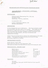
Showing 3340 items matching "engineering"
-
 Ringwood and District Historical Society
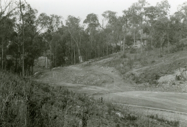
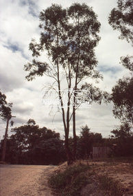
Photographs, 1979-80 MMBW pipe line project at Hubbard Reserve, North Ringwood � View east up the gully
Part of a 43-photo record of the MMBW�s engineering feat in drilling a 12 inch pipe line up to 40 feet deep through rock hardened by volcanic action associated with geological fault that occurs along the line. The work took place from October 1979 to May 1980 on the southern boundary of Hubbard Reserve, North Ringwood. The collection was presented to the Ringwood Historical Research Group by J Clarke on 9th June 1980.E568 N19 13 May 1980 A43 View east up the gully, when all the work was finished -
 Ringwood and District Historical Society
Photographs, 1979-80 MMBW pipe line project at Hubbard Reserve, North Ringwood � Looking east near Debbie Place
Part of a 43-photo record of the MMBW�s engineering feat in drilling a 12 inch pipe line up to 40 feet deep through rock hardened by volcanic action associated with geological fault that occurs along the line. The work took place from October 1979 to May 1980 on the southern boundary of Hubbard Reserve, North Ringwood. The collection was presented to the Ringwood Historical Research Group by J Clarke on 9th June 1980.E567 N16 13 May 1980 A43 Looking east from the ridge above Debbie Place. The finished manhole is in the gully. -
 Ringwood and District Historical Society
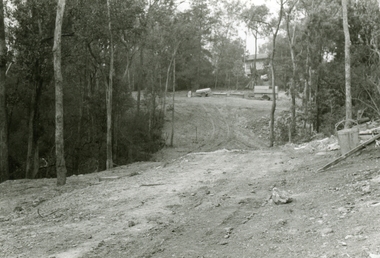
Photographs, 1979-80 MMBW pipe line project at Hubbard Reserve, North Ringwood � View east from Debbie Place
Part of a 43-photo record of the MMBW�s engineering feat in drilling a 12 inch pipe line up to 40 feet deep through rock hardened by volcanic action associated with geological fault that occurs along the line. The work took place from October 1979 to May 1980 on the southern boundary of Hubbard Reserve, North Ringwood. The collection was presented to the Ringwood Historical Research Group by J Clarke on 9th June 1980.E558 N29 13 May 1980 A43 View east from Debbie Place -
 Ringwood and District Historical Society
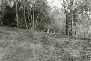
Photographs, 1979-80 MMBW pipe line project at Hubbard Reserve, North Ringwood � Track down to creek bridge
Part of a 43-photo record of the MMBW�s engineering feat in drilling a 12 inch pipe line up to 40 feet deep through rock hardened by volcanic action associated with geological fault that occurs along the line. The work took place from October 1979 to May 1980 on the southern boundary of Hubbard Reserve, North Ringwood. The collection was presented to the Ringwood Historical Research Group by J Clarke on 9th June 1980.E565 N12 13 May 1980 A43 My old track down to the bridge over the creek. The pipe line went to the right of the big tree 40-foot down. -
 Ringwood and District Historical Society
Photographs, 1979-80 MMBW pipe line project at Hubbard Reserve, North Ringwood � The new trach goes on down to Debbie Place
Part of a 43-photo record of the MMBW�s engineering feat in drilling a 12 inch pipe line up to 40 feet deep through rock hardened by volcanic action associated with geological fault that occurs along the line. The work took place from October 1979 to May 1980 on the southern boundary of Hubbard Reserve, North Ringwood. The collection was presented to the Ringwood Historical Research Group by J Clarke on 9th June 1980.E566 N13 13 May 1980 A43 The parting of the ways. My old track goes left to Burlock Avenue. The new way goes on down to Debbie Place. -
 Ringwood and District Historical Society
Photographs, 1979-80 MMBW pipe line project at Hubbard Reserve, North Ringwood � Manhole behind 29 Burlock Avenue
Part of a 43-photo record of the MMBW�s engineering feat in drilling a 12 inch pipe line up to 40 feet deep through rock hardened by volcanic action associated with geological fault that occurs along the line. The work took place from October 1979 to May 1980 on the southern boundary of Hubbard Reserve, North Ringwood. The collection was presented to the Ringwood Historical Research Group by J Clarke on 9th June 1980.E566 N5 13 May 1980 A43 Manhole behind 29 Burlock Avenue, 38 feet deep. Debbie place is on the far right. -
 Ringwood and District Historical Society
Photographs, 1979-80 MMBW pipe line project at Hubbard Reserve, North Ringwood � The manhole in the creek
Part of a 43-photo record of the MMBW�s engineering feat in drilling a 12 inch pipe line up to 40 feet deep through rock hardened by volcanic action associated with geological fault that occurs along the line. The work took place from October 1979 to May 1980 on the southern boundary of Hubbard Reserve, North Ringwood. The collection was presented to the Ringwood Historical Research Group by J Clarke on 9th June 1980.E563 1 April 1980 A43 The manhole in the creek, waiting until boring is finished. -
 Ringwood and District Historical Society
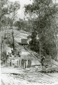
Photographs, 1979-80 MMBW pipe line project at Hubbard Reserve, North Ringwood � Tracked drill rig
Part of a 43-photo record of the MMBW�s engineering feat in drilling a 12 inch pipe line up to 40 feet deep through rock hardened by volcanic action associated with geological fault that occurs along the line. The work took place from October 1979 to May 1980 on the southern boundary of Hubbard Reserve, North Ringwood. The collection was presented to the Ringwood Historical Research Group by J Clarke on 9th June 1980.E561 N16 3 March 1980 A43 Tracked drill rig on the line of trench for sewer to Debbie Place -
 Ringwood and District Historical Society
Photographs, 1979-80 MMBW pipe line project at Hubbard Reserve, North Ringwood � Air track drill rig
Part of a 43-photo record of the MMBW�s engineering feat in drilling a 12 inch pipe line up to 40 feet deep through rock hardened by volcanic action associated with geological fault that occurs along the line. The work took place from October 1979 to May 1980 on the southern boundary of Hubbard Reserve, North Ringwood. The collection was presented to the Ringwood Historical Research Group by J Clarke on 9th June 1980.E561 N19 3 March 1980 A43 Air track drill rig in position as in N18 -
 Ringwood and District Historical Society
Photographs, 1979-80 MMBW pipe line project at Hubbard Reserve, North Ringwood � Last days of the boring
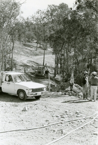
Part of a 43-photo record of the MMBW�s engineering feat in drilling a 12 inch pipe line up to 40 feet deep through rock hardened by volcanic action associated with geological fault that occurs along the line. The work took place from October 1979 to May 1980 on the southern boundary of Hubbard Reserve, North Ringwood. The collection was presented to the Ringwood Historical Research Group by J Clarke on 9th June 1980.E561 N1 1 April 1980 A43 Last days of the boring. The mole had broken between the last two shafts. Dominic Di Nezza and Glen Pearson discuss further moves to release it. -
 Ringwood and District Historical Society
Photographs, 1979-80 MMBW pipe line project at Hubbard Reserve, North Ringwood � Drill rig
Part of a 43-photo record of the MMBW�s engineering feat in drilling a 12 inch pipe line up to 40 feet deep through rock hardened by volcanic action associated with geological fault that occurs along the line. The work took place from October 1979 to May 1980 on the southern boundary of Hubbard Reserve, North Ringwood. The collection was presented to the Ringwood Historical Research Group by J Clarke on 9th June 1980.E561 N17 3 March 1980 A43 Powder-monkey marks out the spots for holes -
 Ringwood and District Historical Society
Photographs, 1979-80 MMBW pipe line project at Hubbard Reserve, North Ringwood � View towards Debbie Place
Part of a 43-photo record of the MMBW�s engineering feat in drilling a 12 inch pipe line up to 40 feet deep through rock hardened by volcanic action associated with geological fault that occurs along the line. The work took place from October 1979 to May 1980 on the southern boundary of Hubbard Reserve, North Ringwood. The collection was presented to the Ringwood Historical Research Group by J Clarke on 9th June 1980.E561 N15 3 March 1980 A43 View towards Debbie Place, showing 2 swivel cranes at shafts, timber of manhole in creek, the tracked drill rig and its compressor caravan. -
 Ringwood and District Historical Society
Photographs, 1979-80 MMBW pipe line project at Hubbard Reserve, North Ringwood � Boring mole pit
Part of a 43-photo record of the MMBW�s engineering feat in drilling a 12 inch pipe line up to 40 feet deep through rock hardened by volcanic action associated with geological fault that occurs along the line. The work took place from October 1979 to May 1980 on the southern boundary of Hubbard Reserve, North Ringwood. The collection was presented to the Ringwood Historical Research Group by J Clarke on 9th June 1980.E561 N14 3 March 1980 A43 View west behind No. 29 Burlock Avenue, showing gantry over manhole 38 feet deep. -
 Ringwood and District Historical Society
Photographs, 1979-80 MMBW pipe line project at Hubbard Reserve, North Ringwood � The work on sewer line from 29-39 Burlock Avenue
Part of a 43-photo record of the MMBW�s engineering feat in drilling a 12 inch pipe line up to 40 feet deep through rock hardened by volcanic action associated with geological fault that occurs along the line. The work took place from October 1979 to May 1980 on the southern boundary of Hubbard Reserve, North Ringwood. The collection was presented to the Ringwood Historical Research Group by J Clarke on 9th June 1980.E561 N11 3 March 1980 A43 The work on sewer line from 29-39 Burlock Avenue. Lundy-Clarke's place on sky-line. -
 Ringwood and District Historical Society
Photograph, 1979-80 MMBW pipe line project at Hubbard Reserve, North Ringwood. Debbie Place from the east end
Part of a 43-photo record of the MMBW's engineering feat in drilling a 12 inch pipe line up to 40 feet deep through rock hardened by volcanic action associated with geological fault that occurs along the line. The work took place from October 1979 to May 1980 on the southern boundary of Hubbard Reserve, North Ringwood. The collection was presented to the Ringwood Historical Research Group by J Clarke on 9th June 1980.E550 N12 Dec 1979 A43 Debbie Place from the east end -
 Ringwood and District Historical Society
Photographs, 1979-80 MMBW pipe line project at Hubbard Reserve, North Ringwood � View from Debbie Place, preliminary sewer work
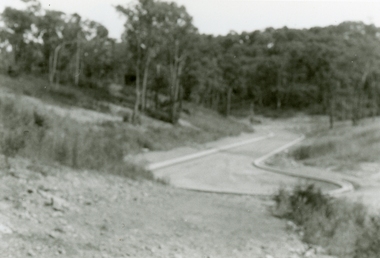
Part of a 43-photo record of the MMBW�s engineering feat in drilling a 12 inch pipe line up to 40 feet deep through rock hardened by volcanic action associated with geological fault that occurs along the line. The work took place from October 1979 to May 1980 on the southern boundary of Hubbard Reserve, North Ringwood. The collection was presented to the Ringwood Historical Research Group by J Clarke on 9th June 1980.E561 N13 28 Feb 1980 A43 View from Debbie Place, preliminary sewer work -
 Ringwood and District Historical Society
Photographs, 1979-80 MMBW pipe line project at Hubbard Reserve, North Ringwood � Line of tunnel shafts behind 29-39 Burlock Avenue
Part of a 43-photo record of the MMBW�s engineering feat in drilling a 12 inch pipe line up to 40 feet deep through rock hardened by volcanic action associated with geological fault that occurs along the line. The work took place from October 1979 to May 1980 on the southern boundary of Hubbard Reserve, North Ringwood. The collection was presented to the Ringwood Historical Research Group by J Clarke on 9th June 1980.E561 N10 Feb 1980 A43 Line of tunnel shafts behind 29-39 Burlock Avenue. Horizontal gantry was above the manhole in the corner of No. 29. -
 Ringwood and District Historical Society
Photographs, 1979-80 MMBW pipe line project at Hubbard Reserve, North Ringwood � First hole west of bore hole at 39 Burlock Avenue
Part of a 43-photo record of the MMBW�s engineering feat in drilling a 12 inch pipe line up to 40 feet deep through rock hardened by volcanic action associated with geological fault that occurs along the line. The work took place from October 1979 to May 1980 on the southern boundary of Hubbard Reserve, North Ringwood. The collection was presented to the Ringwood Historical Research Group by J Clarke on 9th June 1980.E561 N9 Feb 1980 A43 First hole west of bore hole at 39 Burlock Avenue -
 Bendigo Historical Society Inc.
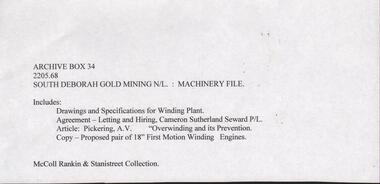
Document - MCCOLL, RANKIN AND STANISTREET COLLECTION: SOUTH DEBORAH GOLD MINES NL - MACHINERY FILE, 1946
Documents: brown manila folder. On front 'South Deborah Gold Mines NL. Machinery File' Contains letters and documents secured within folder with binder, from T.J. Jorgensen, consulting engineer and contractor, F.W. Milne & Son, General Engineers, Ministry of Munitions, Holland Bros.., Thompsons Engineering & Pipe Co., Castlemaine. All documents relate to provision of machinery work at the Deborah Gold Mines. Attached is a selection from the folder.variousorganization, mining, south deborah gold mines nl, mccoll, rankin and stanistreet: south deborah gold mines nl, t.j. jorgensen, f.w. milne & son, thompsons engineering & pipe co., gold mining, engineers, machinery -
 Wodonga & District Historical Society Inc
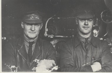
Photograph - Fred Rochow Railways Collection - Driver Ray Murphy and Fireman Bill Welsh, 1942
The Fred Rochow Railways Collection incorporates photos related to the operation of the Wodonga Railway Station including different types of trains and railways staff C. 1930 – 1990. It was donated to the Wodonga Historical Society by Fred Rochow, a railwayman who spent many years based in Wodonga. He joined the Victorian Railways on 17th June l947 and retired in 1988. For some time, he was a member of the Australian Federated Union of Locomotive Enginemen and served a term as a member of the Trades Hall Council. He had an extensive knowledge of the struggles that took place to achieve better conditions for railway workers. Fred worked for many years as a fireman and then worked his way up the ranks to driver, experiencing many changes from the days of steam locomotives through to diesel trains, locomotives and even the modern XPT train. He worked throughout Victoria at different stages of his career, with his final working years focused on the northeast of Victoria and the Albury to Melbourne line. After his retirement, Fred continued to share his love of steam miniature trains with the community.This collection has local and statewide significance as it captures images of trains, locomotives and personnel who operated the railway services in Wodonga and throughout Northeast Victoria. The railways played a critical role in opening up Victoria and connecting Australia for trade, business, social communication and transport.Driver Ray Murphy and Fireman Bill Welsh in S-class Locomotive cab at Spencer Street Station, Melbourne. S Class Diesel Locomotives The eighteen members of the S Class were ordered in two batches by the Victorian Railways from Clyde Engineering for express passenger and freight workings, with the final eight locomotives ordered specifically to work the North-East standard gauge line. Many were named after prominent Victorians.railways wodonga, fred rochow, wodonga railwaymen, ray murphy, bill welsh -
 Melbourne Tram Museum
Document - Technical pamphlet/s, Melbourne & Metropolitan Tramways Board (MMTB), "Z3 Class tram - Melbourne Australia", c1980
Five page stapled photocopied technical pamphlet, providing detailed specifications and description of the Z3 vehicle produced by Commonwealth Engineering(Vic) in conjunction with AEG Telefunken and DUWAG. Provides details for Z3 class trams. Produced by the MMTB. Titled "Z3 Class tram - Melbourne Australia". Second copy from John Prideaux added 18/6/2017. Different version added 31/3/2019 from donation of Brian Weedon.Has word "yellow" in top right hand corner.trams, tramways, z3 class, mmtb, commonwealth engineering, specification, z class -
 Federation University Historical Collection
Book, The Economics of Mining (Non-Ferrous Metals), 1938, 1938
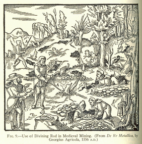
The book was used by Charles Bacon who studied at the University of Nevada in the late 1930s/early 1940s. Bacon worked at Bunker Hill Mines and Kellogg Idaho, before arriving in Australian in 1951. He worked for CN Myers, a company involved with paper converting. CN Myers was a family business (on Charles Bacon's maternal line). The Mackay School of Mines, Nevada was established in 1908. At the time of writing this mook T.J. Hoover was Professor of Mining and Metallurgy and Dean of the School of Engineering at Stanford University. Theodore Jesse Hoover, brother of the 31st President of the United States, was born in West Branch, Iowa, on January 28, 1871. He attended Stanford and received the Bachelor of Arts degree in Geology and Mining in 1901. Following graduation his professional career started with the position of assayer for the Keystone Consolidated Mining Company. After one year, he became assistant manager for the Standard Consolidated Mine, and a year later he was promoted to manager of the operation. In 1907 Hoover went to London as general manager of Minerals Separation, Ltd. This company was developing the froth flotation process for recovering minerals from ores. Hoover took an active part in the development of the flotation concentration process and authored one of the first books on the concentration of ores by flotation. After four years with Minerals Separation, Ltd., Hoover entered private practice as a consulting mining and metallurgical engineer with offices in London and in San Francisco. He was very successful and held positions of consulting engineer, managing director, director, and president of many mining companies in America, Europe, Asia, Africa, and Australia. He returned to Stanford in 1919 as Professor of Mining and Metallurgy and Executive Head of the Department of Mining and Metallurgy. His experience and ability in organization made him a natural leader. He was influential in the formation of the School of Engineering at Stanford. The School was formed in 1925 and he was made dean, a position he held until his retirement in 1936. As dean of engineering, he promoted a broad fundamental training program for undergraduate engineering students. Under his guidance, emphasis was placed upon graduate work and he was responsible for developing strong graduate engineering curricula at Stanford. While dean he continued teaching and his course, "The Economics of Mining," developed into a book which was published in 1933. He became interested in the functions of engineers and, with Professor Fish, wrote a book entitled "The Engineering Profession" which was published in 1940 and revised in 1950. In addition to his academic activities he was generous in his hospitality. Faculty and students alike enjoyed the annual field day and barbecue at his Rancho del Oso, near Santa Cruz. He was widely read and had a lively interest in all the things he encountered. He speculated on the antiquity of man and man's early production processes. To verify an idea regarding flint tools, he studied their shapes and became proficient in making arrow heads. He was also interested in wild life, and was one of the founding members of the Cooper Ornithological Society. (http://engineering.stanford.edu/about/bio-hoover) Blue hard covered book of 547 pages including an index. Contents include mine valuation (sampling, ore deposits, ore reserves, financial provisions, sale of mineral product, metal prices, reports) and Mining Organization (Co-operative effort, Mining Companies, Promoting Mining Enterprises, fluctuations of share prices, valuation of mining shares, fakes and fallacies, the mining Engineer and the law) and Mine Management (Organization of staff, mine manager, efficiency, industrial relations, training and discipline, safety). Inside front cover 'Charles Bacon Mackay School of Mines"charles bacon, mining engineering, metallurgy, university of nevada, mackay school of mines, stanford, bacon, mining, economics, divining, theodore hoover -
 Melbourne Tram Museum
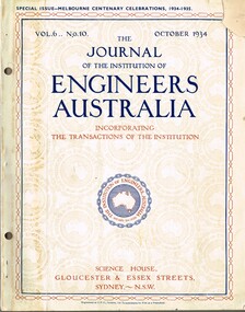
Magazine, Engineers Australia, Journal of the Institution of Engineers Australia" - Vol 6, No. 10, Oct. 1934, "Metropolitan and Provincial Tramways", Oct. 1934
Journal or magazine - stapled pages approx. 100 printed on semi gloss paper, with glue outside cover, titled Journal of the Institution of Engineers Australia" - Vol 6, No. 10, Oct. 1934 - Special issue - Melbourne Centenary Celebrations 1934 - 1935. Contains transactions of radio frequency, institution and related activities, and 100 years of Engineering in Victoria. These include maps of Victoria and Melbourne, Engineering Education (Kernot), Metropolitan Roads and Bridges by J. Noble Anderson City Engineer of Richmond, Country Roads and Bridges, Railway Development (VR), Metropolitan and Provincial Tramways (Strickland and Russell), Port of Melbourne, Outer ports, air transport, water supply, sewerage and drainage, gas industry, electricity supply, communications (telephone and telegraph), industrial development and mining. Has ads for British Insulated cables, Thompsons Engineer, Goodyear, GEC - British General Electric, Associated General electric, Vickers and many other companies. Photocopy of article from the Bob Lilburn collection.trams, tramways, centenary, victoria, tramways, railways, secv, mmtb, cable trams -
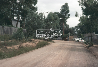
 Eltham District Historical Society Inc
Slide, Adam Crescent, Montmorency, c. Feb. 1981
One of a series of images of road infrastructure focussed on Adam Crescent in Montmorency taken by Eltham Shire Council Planning and Engineering officers. They provide perspective of the changes in housing styles and road development that began sweeping in from the mid 1970s with increasing urbanisation of what was once more outlying suburbs and regions. All images have been identified with GPS though house numbers have changed35 mm colour positive transparency (1 of 21) Mount - Kodak Kodachrome CardProcessed Feb 1981adam crescent, infrastructure, montmorency, roads -
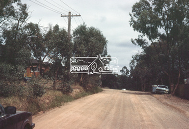
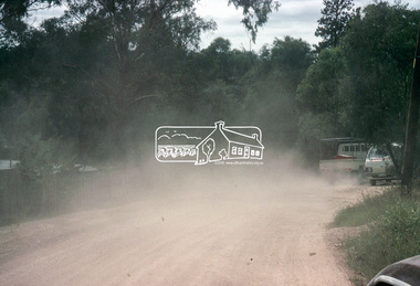
 Eltham District Historical Society Inc
Slide, Adam Crescent, Montmorency, c. Feb. 1981
One of a series of images of road infrastructure focussed on Adam Crescent in Montmorency taken by Eltham Shire Council Planning and Engineering officers. They provide perspective of the changes in housing styles and road development that began sweeping in from the mid 1970s with increasing urbanisation of what was once more outlying suburbs and regions. All images have been identified with GPS though house numbers have changed35 mm colour positive transparency (1 of 21) Mount - Kodak Kodachrome CardProcessed Feb 1981adam crescent, infrastructure, montmorency, roads, gordon grove -
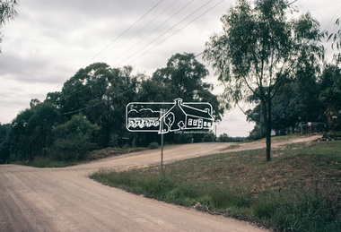
 Eltham District Historical Society Inc
Slide, Adam Crescent, Montmorency, c. Feb. 1981
One of a series of images of road infrastructure focussed on Adam Crescent in Montmorency taken by Eltham Shire Council Planning and Engineering officers. They provide perspective of the changes in housing styles and road development that began sweeping in from the mid 1970s with increasing urbanisation of what was once more outlying suburbs and regions. All images have been identified with GPS though house numbers have changed35 mm colour positive transparency (1 of 21) Mount - Kodak Kodachrome CardProcessed Feb 1981adam crescent, infrastructure, montmorency, roads -
 Eltham District Historical Society Inc
Slide, Adam Crescent, Montmorency, c. Feb. 1981
One of a series of images of road infrastructure focussed on Adam Crescent in Montmorency taken by Eltham Shire Council Planning and Engineering officers. They provide perspective of the changes in housing styles and road development that began sweeping in from the mid 1970s with increasing urbanisation of what was once more outlying suburbs and regions. All images have been identified with GPS though house numbers have changed35 mm colour positive transparency (1 of 21) Mount - Kodak Kodachrome CardProcessed Feb 1981adam crescent, infrastructure, montmorency, roads, gordon grove -
 Eltham District Historical Society Inc
Slide, Adam Crescent, Montmorency, c. Feb. 1981
One of a series of images of road infrastructure focussed on Adam Crescent in Montmorency taken by Eltham Shire Council Planning and Engineering officers. They provide perspective of the changes in housing styles and road development that began sweeping in from the mid 1970s with increasing urbanisation of what was once more outlying suburbs and regions. All images have been identified with GPS though house numbers have changed35 mm colour positive transparency (1 of 21) Mount - Kodak Kodachrome CardProcessed Feb 1981adam crescent, infrastructure, montmorency, roads -
 Eltham District Historical Society Inc
Slide, Adam Crescent, Montmorency, c. Feb. 1981
One of a series of images of road infrastructure focussed on Adam Crescent in Montmorency taken by Eltham Shire Council Planning and Engineering officers. They provide perspective of the changes in housing styles and road development that began sweeping in from the mid 1970s with increasing urbanisation of what was once more outlying suburbs and regions. All images have been identified with GPS though house numbers have changed35 mm colour positive transparency (1 of 21) Mount - Kodak Kodachrome CardProcessed Feb 1981adam crescent, infrastructure, montmorency, roads