Showing 2994 items matching "parks victoria"
-
 Ballarat Tramway Museum
Photograph - Digital image Set of 10, Tony Smith, 1971
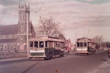
Yields information about Ballarat Tramways and trams prior to the closure of the tramway system.Set of 10 digital images of Ballarat trams prior to closure, scanned from original slides by Tony Smith, 1971 prior to closure of the system. The following photos have suffered colour change and showing some deterioration - fungal growth. .1 - 13 (Sturt St West) and 27 (Victoria St with Twin Lakes sign) crossing at King St loop with St Alipius church in the background. .2 - 13 (Sturt St West) and 17? (Mt Pleasant) crossing at Parker St loop, with the Ballarat College in the background. .3 - Single trucker, inbound, approaching the Parker St Loop, showing Mt Pleasant. .4 - 30 in Sturt St, descending the hill to Grenville St, with other trams in the background, including Woolworths Big W and the Dickins Store. Also has the 8 hour monument. 30 showing City. .5 - 37 running Special, no passengers, crossing Lydiard St Nth, heading for Grenville St. Has the Titanic bandstand, Mechanics Institute in the background. .6 - 33 and three other single truckers in the City Loop - has the Ballarat Gas Co and other buildings in the background. .7 - 37 showing Special passing 33 and other trams parked in the City Loop. Has Dickins, Ballarat Gas Co, Edmonds, Patersons store in the background. .8 - 17 crossing Lydiard St Nth in Sturt St. 17 has destination of Gardens via Drummond Nth, and a Twin Lakes sign. Includes the T&G sign in the background. .9 - 31, a single trucker and bogie tram crossing at Depot loop, Wendouree Parade - 31 showing Victoria St. .10 - 17 waiting in Gardens Loop, showing Mt Pleasant.trams, tramways, king st, victoria st, sturt st west, sturt st, grenville st, city loop, gardens loop, wendouree parade, tram 13, tram 27, tram 30, tram 37, tram 33, tram 17, tram 31 -
 Ballarat Tramway Museum
Photograph - Digital image Set of 10, Tony Smith, 5/09/1971 12:00:00 AM
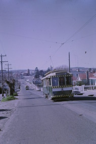
... Victoria Park... system. Trams tramways Mt Pleasant Barkly St Grant St Victoria ...Yields information about Ballarat Tramways and trams prior to the closure of the tramway system.Set of 10 digital images of Ballarat trams prior to closure, scanned from original slides by Tony Smith, 1971 prior to closure of the system. This set of slides, possibly on the last weekend of Mt Pleasant services - closure took place on 5/9/1971. .1 - 13 outbound in Barkly St, Mt Pleasant - with another single trucker and the Ballarat Fire Station in the background. .2 - Bogie tram and single trucker at Grant St Loop. Has the Mobile service station on the right hand side. Note the family sitting on the steps of a house on the left side watching proceedings. .3 - 14 (Mt Pleasant) and 39 ditto. .4 - 27? and 39 crossing at the Morrison St loop. .5 - 14 and another single trucker at Mt Pleasant terminus. Has the corner store in the background with adverts for Robur Tea, Womens Weekly and Coca Cola. .6 - 39 and two single truckers at the Mt Pleasant terminus. .7 - View looking south along Ripon St from Mair St, with power station buildings on the right hand side. Shows the power distribution poles on the street. .8 - Scrubber tram on 0 road with tennis court alongside. .9 - 40 running special in Wendouree Parade, near the Haddon St intersection. .10 - 40 turning from Macarthur St into Drummond St Nth.trams, tramways, mt pleasant, barkly st, grant st, victoria park, sturt st west, ripon st, view st, depot, wendouree parade, drummond st nth, macarthur st, closure, tram 14, tram 39, tram 13, tram 26, tram scrubber, 40 -
 Ballarat Tramway Museum
Photograph - Digital image, Rose Stereograph Co, c1930
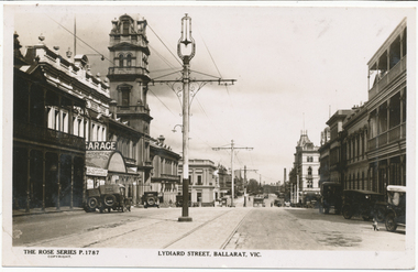
Yields information the appearance of Lydiard St north, centre poles and buildings.Digital image from the Wal Jack Ballarat Album of Rose Series postcard No. P 1787, of Lydiard St North looking south from near Mair St. shows the centre poles prior to their removal. A number of motor cars are parked in the street, a dog on the right hand side, and ESCo tram has just rounded the corner and about to climb the small hill. Published by Rose Stereograph Co., Armadale Victoria. For rear of postcard - see image i2.in pencil on rear "Old type of electric tram"trams, tramways, esco, lydiard st, poles -
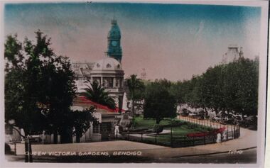
 Bendigo Historical Society Inc.
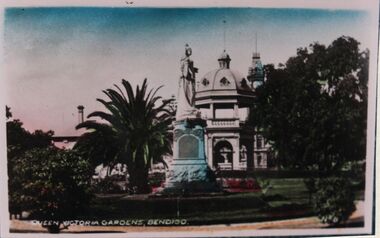
Photograph - QUEEN VICTORIA GARDENS BENDIGO
... BENDIGO Parks and gardens queen victoria gardens Photo of postcard ...Photo of postcard: Postcard shows Queen Victoria Gardens, Bendigo ( written on bottom in white, No 6?) Handcoloured original shows statue of Queen Victoria forefront, RSL building behind.bendigo, parks and gardens, queen victoria gardens -
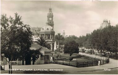
 Bendigo Historical Society Inc.
Photograph - VICTORIA GARDENS BENDIGO
... BENDIGO Parks and gardens queen victoria gardens Photo of postcard ...Photo of postcard. Written on bottom in white : Queen Victoria Gardens Bendigo. RSL building in centre, Pall Mall on right. Baby Health Centre in foreground. No 10. Hand coloured photo.bendigo, parks and gardens, queen victoria gardens -
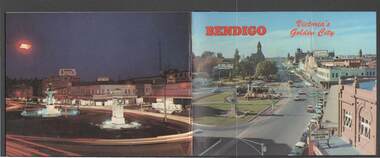 Bendigo Historical Society Inc.
Book - BENDIGO: VICTORIA'S GOLDEN CITY
Coloured booklet of various scenes and buildings in and around Bendigo, titled Bendigo Victoria's Golden City. The front cover has a scene of Charing Cross looking towards Pall Mall. Inside the front cover is a very brief history and some Historical Buildings are mentioned. They are: Fortuna, Shamrock Hotel, Gold Mines Hotel, City Hall, Post Office, Law Courts, the Home for the Aged, Sacred Heart Cathedral, St. Paul's, Specimen Cottage, Log Lock-up and the Chinese Joss House. The coloured pictures inside are: The Central Deborah Gold Mine, Fortuna, Miner's Cottage, The Gold Mines Hotel, Victoria Hill, Bendigo Law Courts, Eaglehawk Log Lock-up, Look-out Tower Rosalind Park, Alexandra Fountain - Charing Cross, Conservatory Gardens with Law Courts in background, Inside the Conservatory, Bendigo Home & Hospital for the Aged - Victoria's 'White House', Sacred Heart Cathedral, Chinese Joss House, Chinese Joss House - Interior of the Main Temple, Bendigo Pottery - Potter at work, Bendigo Municipal Offices, Bendigo Institute of Technology at Flora Hill, Mt. Alvernia Hospital, Cobb & Co Coach, R Class Locomotive, Bendigo Tramcar, Lake Weeroona and Lake Eppalock Pumping Station. Some more attractions are mentioned inside the back cover. On the back cover is the Cenotaph - the only scale replica of the Whitehall Cenotaph - and Alexandra Fountain by night.Nucolorvue Productions Pty Ltdbendigo, tourism, photographs of bendigo icons, bendigo - victoria's golden city, fortuna, shamrock hotel, gold mines hotel, city hall, post office, law courts, home for the aged, victoria's 'white house', sacred heart cathedral, st paul's, specimen cottage, log lock-up, chinese joss house, charing cross, cenotaph, alexandra fountain, centra deborah gold mine, army cartographic unit, miner's cottage, harvey town, victoria hill, look-out tower rosalind park, conservatory gardens, conservatory, bendigo pottery, bendigo municipal offices, bendigo institute of technology, mt alvernia hospital, cobb & co coach, r class locomotive, bendigo railway station, bendigo tramcar, lake weeroona, lake eppalock pumping station, art gallery, historical museum eaglehawk, melville's caves, whitehall cenotaph, nucolorvue productins pty ltd, national library of australia -
 Bendigo Historical Society Inc.
Photograph - LESLIE JOHN BAGUST COLLECTION PHOTO OF QUEEN VICTORIA GARDENS, 1940
... BENDIGO Parks and gardens queen victoria gardens Leslie John ...Leslie John Bagust Collection. Black and white photo of the Queen Victoria Gardens. In the foreground is the baby health centre, (since removed), Queen Victoria statue in white, centre background shows the RSL Hall and part of the roof and the clock tower of the Old Bendigo post Office. Background right the tower of the Shamrock Hotel and centre background is the town of the Bendigo School of mines. The right shows vehicles parked along Pall Mall. To the right of the health centre there is a small white statue, of unknown representation. At the bottom of the photo in white Queen Victoria Gardens, Bendigo and to the right is No.10.bendigo, parks and gardens, queen victoria gardens -
 Queenscliffe Maritime Museum
Vehicle - Yacht hull
Seen as an excellent recreation for a maritime power, racing or cruising in purpose-built vessels became increasingly popular in Britain from the beginning of the 19th century. Some immigrants brought their enthusiasms to Port Phillip Bay, holding the first regatta in 1838. The Devil Afloat, the first unequivocal pleasure yacht, arrived a year later. Regattas were organised intermittently, featuring wagers on both rowing and sailing races. The Victoria Yacht Club, founded in 1856, soon folded, but another club of that name was established in 1872 and became the Royal Yacht Club of Victoria based at Williamstown. The Albert Park Yacht Club also began on the newly improved lagoon in 1872, other clubs soon followed and inter-club regattas were organised. In the 1880s the popularity of larger yachts built for cruising, as well as for racing, increased. Sailing in smaller boats consolidated in the first three decades of the 20th century, with several more clubs formed. After the great storm of 1932 destroyed many yachts the fleet was rebuilt with new designs such as Charles Peel's Jubilee One-Design Class dinghies.Jubilee yachts were popular in Port Phillip between 1930 to 1970. In later years, they were later made of fibreglass.Timber hull of a Jubilee class yacht J82 named FLASH. jubilee yacht, timber hull -
Queenscliffe Maritime Museum
Machine - Bandsaw
Bandsaw was operating in the former Higgs Brothers Boatyard which along with Charlie Blunt’s Boatbuilders and Barrow’s Boatyard operated from the Western Beach boat yard which is now a park in Geelong. The park design honours the area’s extensive industrial past, showcasing remaining infrastructure and some historic original boats from the area. Interpretive signage onsite provides further information about the history of the area, including the addition of sea baths in the 1840s. Higgs Brothers were the builders of many boats still in existence in Victoria.A 1908 Wolfenden bandsawWolfendengeelong, higgs brothers boat yard, wolfenden wood working machinery, boat buiding -
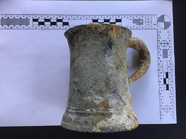 Queenscliffe Maritime Museum
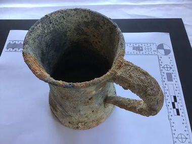
Functional object - Tankard
tankards from the wreck of the Loch ArdThe Loch Ard is historically significant as one of Victoria and Australia's worst shipwreck tragedies. It is archaeologically significant for its remains of a large international passenger and cargo ship. It is highly educationally and recreationally significant as one of Victoria's most spectacular diving sites, and popular tourist sites in Port Campbell National Park.Pewter tankard with glass basetankard, loch ard, shipwrecks -
 Queenscliffe Maritime Museum
Functional object - Tankard
The Loch Ard is historically significant as one of Victoria and Australia's worst shipwreck tragedies. It is archaeologically significant for its remains of a large international passenger and cargo ship. It is highly educationally and recreationally significant as one of Victoria's most spectacular diving sites, and popular tourist sites in Port Campbell National Park.Pewter tankard with glass basetankard, loch ard, shipwrecks -
 Queenscliffe Maritime Museum
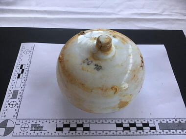
Functional object - Lamp saddle
The Loch Ard is historically significant as one of Victoria and Australia's worst shipwreck tragedies. It is archaeologically significant for its remains of a large international passenger and cargo ship. It is highly educationally and recreationally significant as one of Victoria's most spectacular diving sites, and popular tourist sites in Port Campbell National Park.Round stem base glass saddle glass light saddle, shipwrecks, loch ard -
 Athletics Victoria
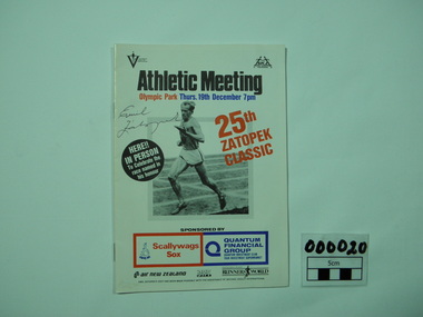
Booklet, Athletic Meeting - 25th Zatopek Meeting, 19/12/1985
This booklet celebrates the 25th Zatopek Classic Athletics Meeting and was attended by Emil Zatopek at Olympic Park, Melbourne 19th December 1985.This booklet is significant because it was the Silver Jubilee of this important event and the booklet must be considered rare as it has been signed by Emil Zatopek who is now deceased.Athletic Programme, Illustrated, cover, 16 pp.Athletic Meeting Olympic Park Signed by EMIL Zatopeksport, athletics, olympic park, emil zatopek, victorian athletic association, marathons -
 Bendigo Historical Society Inc.
Photograph - DAWN SMITH COLLECTION: PHOTOS OF BENDIGO, c1929
Black & White Photograph Alexandra Fountain, Bendigo Souvenir Tourism Set Rose Collection Series c1929. Alexandra Fountain is regarded as one of Bendigo, Victoria, Australia's most prominent landmarks and monuments. The fountain is located in Bendigo's "Charing Cross", the intersection of View Street and Pall Mall. Haring Cross effectively stands at the centre of the city and is one of Bendigo's busiest and most prominent intersections. The fountain stands opposite to the main entrance of Rosalind Park. Alexandra Fountain was funded from the proceeds of the Bendigo Juvenile Industrial Exhibition (1879), a £500 gift from George Lansell and a further £700 from the Sandhurst City Council (now the City of Greater Bendigo). The fountain was designed by W. C. Vahland,] a local architect responsible for some of the cities most prominent buildings.The fountain was named in honour of Alexandra, Princess of Wales and the grand opening (5 July 1881) was attended by her sons Prince Albert and Prince George.bendigo, tourism, alexandra fountain bendigo -
 Bendigo Historical Society Inc.
Document - PETER ELLIS COLLECTION: INFORMATION ON THE BARFOLD GORGE
Foolscap page of information on the Barfold Gorge, by Frank Robbins. Barfold Gorge is compared with the Sydenham Organ Pipes National Park. There is a description of the Gorge. Native vegetation growing there is also mentioned. Turning it into a National Park is mentioned but it is in private ownership and this would require buy back of the land and create access problems as it is a farming area.place, land, barfold gorge, peter ellis collection, barfold gorge, sydenham organ pipes national park, campaspe river, mitchell's falls, queen's falls, piper's creek, turpin's falls, land conservation council, victoria conservation trust, frank robbins -
 Bendigo Historical Society Inc.
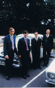
Photograph - PETER ELLIS COLLECTION: PETER ELLIS AND OTHERS, 23rd January, 1973
Colour photograph. 4 men in suit and ties standing in front of Car in parking lot. Back of photo reads: Jan 23 1973 Robin Moors Peter Ellis Frank Robbins John Kellam Deputation to Premier of Victoria RJ Hamer re Whipstick. (Also on Pink sticky note attached to back of photo) Deputation to the Premier (Hamer) 1973 Jan 23rd to get the Whipstick made into a National Park, Ultimately which was granted.photo, group, male -
Ballarat Tramway Museum
Currency - USA One Dollar Note, USA Government, Design first issued 2006
... servicemen were camped in Victoria Park, Ballarat during World War ...USA currency of design first issued in 2006. The obverse features an engraving of George Washington. The reverse shows the Great Seal of the USA. USA servicemen were camped in Victoria Park, Ballarat during World War Two. Representative of USA currency often given as gifts and souvenirs. Note printed on 25% Linen and 75% Cotton.ballarat tramway museum, usa currency -
Ballarat Tramway Museum
Currency - USA One Dollar Note, USA Government, Design first issued 2006
... servicemen were camped in Victoria Park, Ballarat during World War ...USA currency of design first issued in 2013. The obverse features an engraving of George Washington. The reverse shows the Great Seal of the USA. USA servicemen were camped in Victoria Park, Ballarat during World War Two. Representative of USA currency often given as gifts and souvenirs. Note printed on 25% Linen and 75% Cotton.ballarat tramway museum, usa currency -
 Bayside Gallery - Bayside City Council Art & Heritage Collection
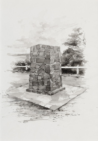
Work on paper - ink and watercolour, Annette Meikle, Moysey Memorial, 1977
In 1977, artist Annette Meikle undertook a commission to illustrate a book recording stories of places and people in the Bayside area. It was published in 1978 as Sandringham Sketchbook, with text by Elizabeth Waters. The sketches were intended to record remaining examples of Bayside’s early architecture and environment, as well as reflect newer architectural changes. Meikle went on to donate 22 of these sketches to Bayside City Council in 2003. Erected in 1964, this stone cairn on Beach Road in Beaumaris marks the site of the wattle and daub cottage of James and Susannah Moysey. James, Susannah and their cousin Nicholas arrived in Victoria in 1844 and leased land on the cliff-top. They built a cottage, cleared the land for sheep and cattle and established vegetable gardens. They later purchased the land and named it Beaumaris Park, derived from the name of the Welsh coastal resort where Edward I built Beau Marais castle.Annette Meikle, Moysey Memorial 1977, ink and watercolour, 35 x 23.5 cm. Bayside City Council Art and Heritage Collection. Donated by the artist, 2003annette meikle, sandringham sketchbook, elizabeth waters, port phillip bay, moysey memorial, coastline, stone cairn, james and susannah moysey, beaumaris -
 Bayside Gallery - Bayside City Council Art & Heritage Collection
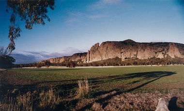
Photograph, Mark Radford, Mount Arapiles, Western Victoria, 2009
Mount Arapiles, or ‘Djurite’ is part of the Mount Arapiles-Tooan State Park approximately 30km west of Horsham. Mark Radford was a former Mayor of Horsham Rural City Council and councillor for 12 years.Mark Radford, Mount Arapiles, Western Victoria 2009, photograph, 36 x 59.7 cm. Bayside City Council Art and Heritage Collection. Gift of Horsham Rural City Council, 2009.mount arapiles, djurite, mount arapiles-tooan state park, horsham, horsham rural city council, mark radford, wimmera, mountain -
 Bayside Gallery - Bayside City Council Art & Heritage Collection
Photograph, Department of Crown Lands and Survey, Victoria, Melbourne Project: Brighton and Elwood, 1976
The Department of Crown Lands and Survey (1857-1983) was responsible for the administration of survey and mapping and the sale, occupation and management of crown land throughout its existence. This aerial photograph shows parts of Brighton and Elwood and was taken on 1 December 1976brighton, elwood, department of crown lands and survey, aerial photograph, elsternwick park, point ormond, north road, ormond esplanade, st kilda street, glen huntly road, bayside, port phillip bay, map, cartographic material, melbourne project 1976 -
 Bayside Gallery - Bayside City Council Art & Heritage Collection
Photograph, Department of Crown Lands and Survey, Victoria, Melbourne Project: Brighton, 1976
The Department of Crown Lands and Survey (1857-1983) was responsible for the administration of survey and mapping and the sale, occupation and management of crown land throughout its existence. This aerial photograph shows parts of Brighton and was taken on 1 December 1976brighton, department of crown lands and survey, aerial photograph, bayside, port phillip bay, map, cartographic material, melbourne project 1976, brighton yacht club, middle brighton baths, north road, st kilda street, new street -
 Bayside Gallery - Bayside City Council Art & Heritage Collection
Photograph, Department of Crown Lands and Survey, Victoria, Melbourne Project: Brighton and Hampton, 1976
The Department of Crown Lands and Survey (1857-1983) was responsible for the administration of survey and mapping and the sale, occupation and management of crown land throughout its existence. This aerial photograph shows parts of Brighton and Hampton and was taken on 1 December 1976. brighton, department of crown lands and survey, aerial photograph, bayside, port phillip bay, map, cartographic material, melbourne project 1976, brighton yacht club, middle brighton baths, hampton, green point, brighton beach, south road, the esplanade, hampton street -
 Bayside Gallery - Bayside City Council Art & Heritage Collection
Photograph, Department of Crown Lands and Survey, Victoria, Brighton, Elwood and Elsternwick, c. 1965-71
The Department of Crown Lands and Survey (1857-1983) was responsible for the administration of survey and mapping and the sale, occupation and management of crown land throughout its existence. This aerial photograph shows parts of Brighton, Elwood and Elsternwick and was taken circa 1965-71.brighton, department of crown lands and survey, aerial photograph, bayside, port phillip bay, map, cartographic material, elwood, elsternwick, elsternwick park, elwood tram depot, elwood pier, new street, glen huntly road, st kilda street, nepean highway -
 Bayside Gallery - Bayside City Council Art & Heritage Collection
Photograph, Department of Crown Lands and Survey, Victoria, Brighton, Brighton East and Bentleigh, c. 1965-71
The Department of Crown Lands and Survey (1857-1983) was responsible for the administration of survey and mapping and the sale, occupation and management of crown land throughout its existence. This aerial photograph shows parts of Brighton, Brighton East and Bentleigh and was taken circa 1965-71.brighton, department of crown lands and survey, aerial photograph, bayside, port phillip bay, map, cartographic material, bentleigh, brighton east, dendy park, dendy street, centre road, nepean highway, south road, football -
 Bayside Gallery - Bayside City Council Art & Heritage Collection
Photograph, Department of Crown Lands and Survey, Victoria, Brighton, Brighton East and Bentleigh, c. 1965-71
The Department of Crown Lands and Survey (1857-1983) was responsible for the administration of survey and mapping and the sale, occupation and management of crown land throughout its existence. This aerial photograph shows parts of Brighton and Brighton East and was taken circa 1965-71.brighton, department of crown lands and survey, aerial photograph, bayside, port phillip bay, map, cartographic material, brighton east, dendy park, dendy street, centre road, nepean highway, south road, brighton golf course, golf -
 Bendigo Historical Society Inc.
Photograph - Glass Slide Photos of Bendigo, Early 1900s
Bendigo followed much the same pattern as Ballarat, and was not ready for an up-to-date studio until 1880 when the Bartlett Bros. (Francis and Henry) who bad conducted a successful business in Melbourne for many years opened a small studio there. It was such a success that they decided to build large modern premises, and Francis made two trips to England and the Continent for the latest ideas. In 1884 Henry died, and to replace him, Francis secured the services of Robert W. Bugg, then employed by Foster & Martin (both pupils of Batchelder's) in Collins Street, Melbourne. In that studio Bugg made some fine portraits of Anthony Trollope during the novelist's long tour of Australia. Francis Bartlett was a keen business man, and Robert Bugg was a great operator and a fine painter. Together, their success was quite outstanding. Fifteen years later Bartlett retired with a fortune, and Bugg took over the studio. Robert William Bugg, one of our leading Painter-Photographers, was born in London in 1853, and came to Melbourne when he was five years old. He became a pupil of Louis Buvelot and, in 1879, a member of the Victorian Academy of Arts. In Bendigo he gave annual exhibitions of his oils and water colours, a number of his exhibitions being officially opened by his friend Alfred Deakin. There are a number of Bugg's Paintings in the Bendigo Art Gallery. All the portraits, landscapes, buildings, and city views illustrated in "Bendigo and Vicinity, 1897", are from photographs taken by Robert Bugg. He was a clever, genial and popular soul, and his influence on the cultural life of his adopted city was considerable. He retired in 1932 and died in his early eighties.Eleven Photos of Bendigo from Glass Plate Negatives, Campaspe River at Axedale, Axe Creek, Lake Weroona, White Hills Botanical Gardens, Conseratory Gardens, Bendigo Fernery. Slides are ex Bartlett Brother Bendigo. history, bendigo, bendigo conservatory gardens, campaspe river axedale, axe creek victoria, lake weroona bendigo, white hills botanical gardens bendigo, bartlett brothers bendigo, rosalind park bendigo -
 Bendigo Historical Society Inc.
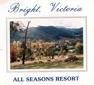
Photograph - Seniors Bus Tour, March 1994
Kangaroo Flat Senior Citizens Club was situated at 21 Lockwood Rd on the site that is now the Kangaroo Flat Library. The club disbanded in 2006.Kangaroo Flat Senior Citizen's Club Bus Tour to Bright Souvenir Photos - photo of tour with scene of Bright on the folder cover. Inside folder cover is a photo of the Kangaroo Flat Bus Lines coach and the Buffalo Budget Motel. The photo of the group is taken in the front of the motel in a park and the rear of the folder are autographs of the groups. Produced by Alpine Fast Photos, 1 Ireland St (next to Post Office), Bright Victoria.history, bendigo, merle lummis collection, bright victoria, kangaroo flat bus lines, kangaroo flat senior citizens club -
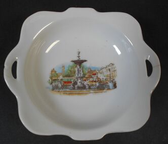 Bendigo Historical Society Inc.
Memorabilia - Alexandra Fountain Souvenir Plate
Alexandra Fountain is a fountain in the Australian city of Bendigo, Victoria. It is regarded as one of the city's most prominent landmarks and monuments The fountain is located in Bendigo's Charing Cross area at the intersection of View Street and Pall Mall. Charing Cross effectively stands at the centre of the city and is one of Bendigo's busiest and most prominent intersections. The fountain stands opposite the main entrance of Rosalind Park. Alexandra Fountain was funded from the proceeds of the Bendigo Juvenile Industrial Exhibition (1879), a £500 gift from George Lansell and a further £700 from the Sandhurst City Council (now the City of Greater Bendigo). The fountain was designed by William Vahland (1828–1915), a local architect responsible for some of the city's most prominent buildings. The fountain was named in honour of Alexandra, Princess of Wales. Its grand opening on 5 July 1881 was attended by her sons Prince Albert and Prince George.White shallow bowl with transfer of Alexandra Fountain in centreMade in Japanalexandra fountain, bendigo landmarks -
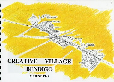 Bendigo Historical Society Inc.
Book - MERLE HALL COLLECTION: ROSALIND PARK CREATIVE VILLAGE BENDIGO PROJECT BOOK, 1995
... Merle Hall Collection: Rosalind Park Creative Village... Hill continued Victoria Hill continued Rosalind Park Lookout ...Merle Hall Collection: Rosalind Park Creative Village Bendigo Project Book. August 1995 Book contains a description, aims of the programme and a linking plan. 35 Pages: Cover Intoduction, The Design Team, Acknowledgement Project Brief Map of Linked Park The Linking Plan described Linking plan graphic Golden Beacon Design Concept Bridge Beacon Entrance to Linear Park Gasworks Café Pavillion Gasworks layout plan Golden Beacons Concept Botanical Gardens Café Botanical Gardens layout plan Victoria Hill Interpretation Centre Victoria Hill layout Victoria Hill plan Victoria Hill continued Victoria Hill continued Rosalind Park Lookout Method 3D Road Map 3D Road Map Continued Implementation Community Participation Oppurtunities, Mosaic Works Appropriate sites Appropriate sites continued Consultaion Summary and Issues Ideas Areas for further consideration Graphic The Design Team - Grant Fink, Jane Marriott, Laszo Biro, James Brearley Graphic Layoutbook