Showing 176562 items
matching streets
-
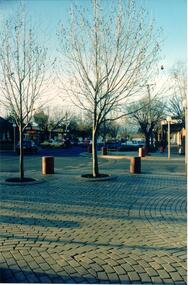
![Footpath on High Street [Kew]](/media/collectors/550653872162f11fb04854aa/items/6132d892e06408664db76a00/item-media/6132d922e06408664db7752b/item-fit-380x285.jpg) Kew Historical Society Inc
Kew Historical Society IncPhotograph - Footpath on High Street [Kew], 1989
Photograph of a footpath in High Street Kew, probably donated by the City of Kew's Engineer's Department.Small, original colour positive [polaroid] photograph of the footpath on the north side of High Street, Kew, looking towards Kew Junction from the vicinity of the Greyhound Hotel."Looking back from pub / High St footpath / 22/8/89"high street -- kew (vic.), street works, footpaths -
 Federation University Historical Collection
Photograph, Aerial View of the Ballarat School of Mines
Aerial view of the Ballarat School of Mines showing the whole block surrounded by Lydiard Street South, Grant Street, Albert Street and Dana Street. ballarat school of mines, aerial -
 Ballarat Heritage Services
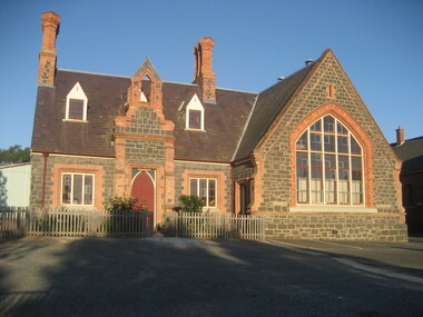
Photograph - Photograph - Colour, Dana Street Primary School From Doveton Street, Ballarat, c2007
Dana Street Primary School No 33 is one of Ballarat's earliest schools. A number of colour photographs of Dana Street Primary School, Ballarat. The photographs feature the original bluestone building, chimney, and other architectural features. The photos were taken at 7am.dana street primary school, dana street state school, bluestone -
 Kew Historical Society Inc
Photograph - 'Fernhurst', 13 Fernhurst Grove, 1978
George Wharton arrived in Melbourne in 1844. An architect and surveyor, he was appointed to lay out the 'Village of Kew' by N.A. Fenwick following the land sales of 1851. A protagonist for Kew's separation from the Boroondara District Road Board, he was elected chairman when Kew achieved municipal status in December 1860. His home, 'Fernhurst', was built in 1866 on eight acres in Studley Park, with a four-storey tower and pyramidal roof. The Italianate home was a prominent Kew landmark. It was demolished in 1979 and replaced by St Paul's College in 1980.Rare colour photograph of what was once a significant mansion in Kew.Original colour positive photograph (Kodak print) of 'Fernhurst' in 1978. Photographed by Stewart West in May 1978, one year before it was demolished, the photograph gives little idea of the large landholding once surrounding the house. Originally accessed from near the corner of Princess Street and Studley Park Road, its gardens had been subdivided in the 1900s and its footprint restricted to 13 Fernhurst Grove. Like many other grand houses, by the 1970s it had been converted into apartments. From the photograph, one can see that the house had retained many of its original features such as the distinctive tower and the wide bow-fronted verandah. The slates on the roof (apart from those on the tower) had been replaced by tiles and the cement render of the exterior painted white. Annotated reverse: "View of Fernhurst Home Taken from Street / 10"fernhurst, 13 fernhurst grove -- kew (vic.), george wharton, italianate architecture, vila maria society, st paul's school for the blind -
 Stawell Historical Society Inc
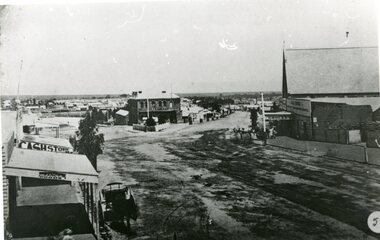
Photograph, Lower Main Street Stawell looking West towards the Unicorn Hotel later Coffee Palace
Lower Main Street looking West towards the Unicorn Hotel later the Coffee Palace. c1882 formerly the Castlemaine Hotel and before then the Royal Hotel. Bullock wagons and horse drawn buggies in street. Railway Goods Shed and Railway Station and Church of Christ visible in distance. Anglican Church roof on right, J & A Price Grocer and Spirit Merchants.B/W. Main Street opposite where the Town Hall is now. Stawell Coffee Palace is in the centre and the Anglican Church on the right. The date is about 1880.?stawell business streetscape -
 Orbost & District Historical Society
black and white photographs, 1960s - 1970s
3289.1 has been taken in the main street of Orbost - Nicholson Street. 3289.2 has been taken on the outskirts of Orbost and indicates that the town population at the time was 2800.These photographs are pictorial record of Orbost C1960s - 1970s.3289.1 is a black / white photograph of a main street with cars parked on both sides of the road and buildings on the left hand side. 3289.2 is a black / white photograph of town entry sign - "ORBOST POP. 2800".orbost-nicholson-street main-street-orbost entry-sign-orbost orbost-1960s-1970s -
Clunes Museum
Photograph - PHOTOGRAPHS
.1 The netball court in the photo was where "Collins Place", Fraser Street, Clunes is now located .3 the warehouse/Clunes Museum building at 36 Fraser Street, Clunes, was a former freezing worksPhotocopies of photographs .1 2 copies of girls playing netball .2 A streetscape of Fraser Street, Clunes .3 Del Mayberry (nee Campbell) and friend. The building that is now the warehouse/Clunes Museum is in the background of this photo, the building was a former freezing works .4 Jean Harling (nee Campbell) and male friend, outside The Club Hotel, Fraser Street, Clunes .5 Landscape of Clunes looking towards Station Flat Road. Port Phillip Mine is in the backgroundcampbell, netball, mayberry, harling -
 City of Whittlesea
Photograph - Thomastown Wesleyan Cemetery, Thomastown Methodist / Wesleyan Cemetery photographs
The cemetery was at the rear of the Wesleyan Church in High Street Thomastown. The church, schoolhouse and cemetery were established in 1854. In 1988 the Uniting Church donated the cemetery to the City of Whittlesea as a permanent reminder and tribute to Thomastown's early British pioneersCemetery is located off High Street Thomastown. Official address is 1w Stewart Street Thomastown. The Wesleyan Church and schoolhouse were built in 1854. The cemetery was laid at out at the rear. The cemetery runs along the grounds of the Thomastown Primary School.The last burial was 1955. The Cemetery is maintained by Whittlesea Council.Bicentennial Plaque donated by Mrs Murial Wuchatsch 1988 -
 Hume City Civic Collection
Photograph, late 1980s
A coloured photograph of the corner of Brook Street and Evans Street, Sunbury, looking towards Macedon Street.post offices, royal hotel, hotels, fire stations, toyworld, businesses, brook street, evans street, sunbury, the corporate personality, george evans collection -
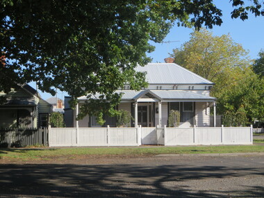 Ballarat Heritage Services
Photograph, Clare Gervasoni, House in South Street, Ballarat, 2020, 13/04/2020
Colour photograph of a house in South Street Street, Ballarat, near the intersection of Armstrong Street South.ballarat, south street, cast iron -
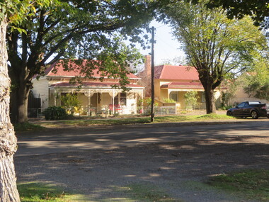 Ballarat Heritage Services
Photograph, Houses in South Street, Ballarat Central, 13/04/2020
Colour photograph of houses in South Street Street, Ballarat, near the intersection of Armstrong Street South.ballarat, south street, cast iron -
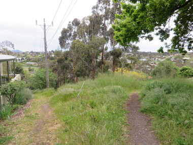 Ballarat Heritage Services
Photograph - Photograph - Colour, W Track, White Flat, Ballarat, 2016, 25/10/2016
Photographs of W-track on South Street, between Hickman Street and Armstrong Street South, Ballarat.white flat, w-track, south street, ballarat -
![Public Works, Barry Street [Kew], 1955](/media/collectors/550653872162f11fb04854aa/items/586f97ffd0ce2307f0beee65/item-media/586f985ed0ce2307f0bf0aa6/item-fit-380x285.jpg) Kew Historical Society Inc
Kew Historical Society IncPhotograph, City of Kew, Public Works, Barry Street [Kew], 1955, 1955
Original photograph donated to the Kew Historical Society by the City's Engineering Department before the amalgamation of Kew into the City of Boroondara in 1994.This 1955 photograph provides a fine snapshot of the work of local government engineering departments in the 1950s. They reveal they types of labour conducted, the techniques used and the equipment and machinery in the possession of the local government authority.Trees in Barry Street, Kew. Barry Street, Kew, looking south to the intersection of Stawell Street. Inscription [pencil] B1955. Stamped: "Please quote No. Gx2320 when ordering. Laurie Richards JW 1528"barry street (kew), gutters, nature strips, street trees -
 Whitehorse Historical Society Inc.
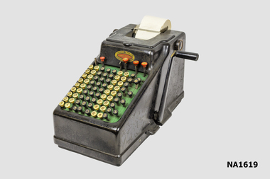
Equipment - Adding Machine
Built on a cast iron base the machine is designed for Sterling currency with a full-keyboard that has five decimal columns for pounds, three columns for shilling and pence, one column for the 10 and 11 pence keys and three farthing (1/4 penny) keys. The machine was imported and distributed by Chartres Pty. Ltd, Capel Court, 375-377 Collins Street MelbourneHand operated comptometer or adding machine with side handle. Sterling currency with full-keyboard with columns for Pounds Shillings and Pence'Chartres Pty Ltd/Capel Court/375-377 Collins Street Melbourne/23359'commerce, office equipment / stationery, bookkeeping -
Federation University Historical Collection
Card - Coffee label, South American Coffee, e 16.98 coffee blend, 1998
Full colour printed card front, single colour black print reverse, promoting South American Coffee, 106 Chapel Street, Windsor (supplier of enclosed beans) as part of invitation to third year graduating show of graphic design students, 1998. The coffee beans were specially blended for the exhibition. Opening held Thursday 12 November 1998, 6.00pm at Chapel Off Chapel, 12 Little Chapel Street, Prahran (Melbourne). Exhibition was then open daily until 23 November 1998. 50mm square card featuring "e 16.98" coffee beans blended by South American Coffee, 106 Chapel Street, Windsor university of ballarat, federation university, graphic design, helmut stenzel -
 Stawell Historical Society Inc
Photograph, Seaby Street Home built by Mary Ellen Hobbs, mine investor
Residence of Frank & Lorraine Stokes Seaby Street. The Home was constructed in 1891 for his widow Mary Ellen Hobbs who with Thomas Kinsella owned the Magdala Cum Moonlight Mine. 7119 Doorway Showing carved wooden pediment above 7119-1 Showing a marble fireplace and oval mirror above 7119-2 Showing the ceiling decorations and light rose 7119-3 Showing a rectangle mirror above another fire place 7119-4 Showing a canopied bed 7119-5 Showing a dark stone fireplace mantle 6 Colour photographs showing the interior of the Hobbs home in Seaby Street.buildings -
 Kew Historical Society Inc
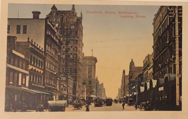
Postcard, Elizabeth Street, Melbourne, Looking North, 1920-1940
Collection of thirty-nine postcards donated by Jillian Rigby which had been owned by her grandparents, George and Edith Weir, who from c.1917 lived at 84 Princess Street, Kew. The mostly 'mint' postcards were purchased in Victoria and while travelling overseas. The sole dated postcard is dated from 1929. The postcards are numbered sequentially from 2017.0058.01-39. The remainder of the collection donated by Jill Rigby which was once owned by the Weirs of Broken Hill and Kew consist of costumes, costume accessories, photographs, and documents.The postcards in the Weir collection, especially those purchased on a trip or trips to the mother country, i.e. United Kingdom, represent a representative sample of sites that were considered significant to those Australians undertaking a reverse grand tour by member of the erstwhile colonies. Those postcards which are early views of Melbourne must have been produced commercially for some decades from the early part of the 20th century.Elizabeth Street, Melbourne, looking north. Coloured postcard. Weir collection."Kew Historical Society Inc"postcards, george and edith weir, elizabeth street - melbourne, weir collection -
 Vision Australia
Photograph - Image, Demolition of Raleigh Street premises, 200
On September 23, 1925 the State Goverment gazetted a transfer of land in Raleigh Street, Prahran to RVIB. This was used to establish a hostel for women apprentices and workers, and building commenced in 1926 and was completed in 1927, at a cost of 3500 pounds. Demand for accommodation was strong and in 1929 a hostel for men was completed. The building were used as hostels for many years, but as demand decreased, the Institution found other ways to utilise the buildings. In 1972, a plant nursery was established on the site and other departments temporarily used the site. In 1994 the Employment Services team moved out of the building and the site was sold to developers.17 col. images of the partially demolished house at Raleigh Street, Prahranroyal victorian institute for the blind, raleigh street hostel -
Port Melbourne Historical & Preservation Society
Photograph - Various streets in Port Melbourne, Ron Laing, 1990 - 1999
Part of Ron LAING's collection of photographs recording Port Melbourne over a thirteen year period. Donated to the PMH&PS by the photographer.A set of 49 colour photographs of varous streets in Port Melbourne, including Graham Street, Swallow Street (before and after wrecking), Bain Street, Graham overpass, Williamstown Road, Normanby Road, Ross Street and Bay Street, Princes Street March 1999 (Number 48 missing August 2015)built environment, ron laing -
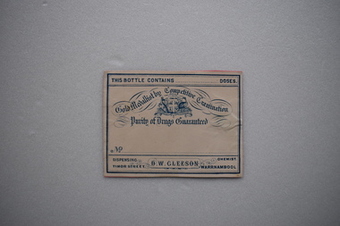 Warrnambool and District Historical Society Inc.
Label, Late 19th century, D.W.Gleeson Chemist
This label comes from the pharmacy of D.W.Gleeson. He had a chemist shop in Timor Street, Warrnambool in the late 19th century. This label is of interest as a memento of a late 19th century chemist in Warrnambool – D.W. GleesonThis is a piece of cream-coloured paper with blue edging, an Australian logo and blue printing. The paper has been pasted on to a piece of pink card. This bottle contains…. doses Gold Medallist by Competitive Examination Purity of Drugs Guaranteed Dispensing Chemist D.W.Gleeson Timor Street Warrnambool d.w.gleeson, chemist, history of warrnambool -
 Sunbury Family History and Heritage Society Inc.
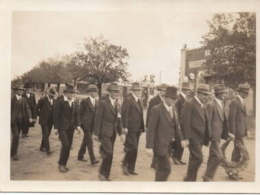
Photograph, Anzac March, C1930s
The group of men in the photograph were marching in file along Brook Street and were making their way to the War Memorial in Stawell Street. They were approaching the intersection of Brook, O'Shanassy and Stawell Streets, known locally as the 5 ways. A non-digital sepia photograph with a cream border of men dressed in suits and hats marching in file along a tree-lined street. One man holds a wreath to place on a memorial. A service station with petrol pump are to the RHS of the photograph.The words 'Kodak Print' and S579 are stamped on the back of the photograph.war memorials, anzac day, brook street, stawell street, o'shanassy street, marches -
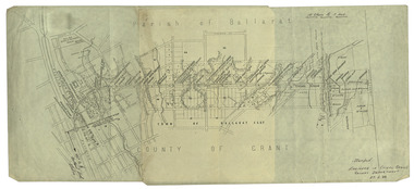 Federation University Historical Collection
Plan, Ballarat Railway Plan, 1888, 27/02/1888
.1) Copy of a Ballarat Railway Plan, running along Belford Street, from the Engineer in Chief's Office, Railway Department. It shows bridges, diversions, culverts and the following streets: Joseph Street, Lal Lal Street, Clayton Street, Belford Street, Rodier Street, trench Street, Stawell Street, Rodier Street, Belford Street, George Street, Eureka Street, Queen Street, Otway Street, Scott Parade, Ross Street, Chamberlain Street, Victoria Street, Water Street. Allotments owned by Tulloch and McLaren, J. Wilson, J. McCarthy, Mrs P. Glynn, E. Ratcliffe, soap works, Orphan Asylum .2) Copy of a plan relating to the construction of the Ballarat Railway Line. It includes shafts for the following companies: South Extended Co, Black Hill; Parade Co.; Black Hill Co.; Spanhake Co. Shaft; Black Hill South Co.; Wellingtonia Gigantiea Co., and the old workings of the Welllingtonia Gigantea Co,ballarat railway plan, belford street, lal lal street, clayton street, rodier street, trench street, south extended co., black hill, parade co., spanhake co. shaft, black hill south co., wellingtonia gigantiea co, railway -
 Kew Historical Society Inc
Plan, Melbourne & Metropolitan Board of Works : Borough of Kew : Detail Plan No.1350, 1910
The Melbourne and Metropolitan Board of Works (MMBW) plans were produced from the 1890s to the 1950s. They were crucial to the design and development of Melbourne's sewerage and drainage system. The plans, at a scale of 40 feet to 1 inch (1:480), provide a detailed historical record of Melbourne streetscapes and environmental features. Each plan covers one or two street blocks (roughly six streets), showing details of buildings, including garden layouts and ownership boundaries, and features such as laneways, drains, bridges, parks, municipal boundaries and other prominent landmarks as they existed at the time each plan was produced. (Source: State Library of Victoria). This plan forms part of a large group of MMBW plans and maps that was donated to the Society by the Mr Poulter, City Engineer of the City of Kew in 1989. Within this collection, thirty-five hand-coloured plans, backed with linen, are of statewide significance as they include annotations that provide details of construction materials used in buildings in the first decade of the 20th century as well as additional information about land ownership and usage. The copies in the Public Record Office Victoria and the State Library of Victoria are monochrome versions which do not denote building materials so that the maps in this collection are invaluable and unique tools for researchers and heritage consultants. A number of the plans are not held in the collection of the State Library of Victoria so they have the additional attribute of rarity.Original survey plan, issued by the MMBW to a contractor with responsibility for constructing sewers in the area identified on the plan within the Borough of Kew. The plan was at some stage hand-coloured, possibly by the contractor, but more likely by officers working in the Engineering Department of the Borough and later Town, then City of Kew. The hand-coloured sections of buildings on the plan were used to denote masonry or brick constructions (pink), weatherboard constructions (yellow), and public buildings (grey). MMBW Plan No. 1350 depicts the western end of Studley Park on the north side of the Studley Park Road. ‘Raheen’, then the home of Sir Henry Wrixon is named, the plan identifying those parts of the house that were built of brick and timber. The two houses between Raheen and the River Yarra are also shown. Other parts of the plan show neighbouring streets: Yarra Street, Studley Park Avenue, Studley Street and Fenwick Street. Each, apart from Fenwick Street was subsequently renamed. At the corner of Fenwick and Stawell Streets, the home of Joseph Butterworth Coombs, later called ‘Hope Mansell’, is represented but unnamed.melbourne and metropolitan board of works, detail plans, mmbw 1350, cartography -
Clunes Museum
Document - RECEIPTED INVOICE
DOCKET [INVOICE] AND RECEIPT VEGETABLE PURCHASED FROM T. STANTON CLUNES. BY A. LEVY & CO. PEEL STREET, BALLARAT.RECEIPTED INVOICE. A. LEVY & CO. WHOLESALE FRUIT AND POTATO MERCHANTS PEEL STREET, BALLARAT. T. STANTON OF CLUNES TO SUPPLY VEGETABLES MARCH 25st,1924.local history, commerce, book keeping, a levy & co -
 Victorian Interpretive Projects Inc.
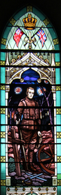
Photograph - Photograph - colour, Clare Kathleen Gervasoni, World War One Memorial Stained Glass Window, Former Barkly Street, Ballarat East, 2015, 05/04/2015
The World War One Memorial Stained glass windows in the Barkly Street Uniting Church resulted from a request made in 1919 by the Barkly Street Young Men's Club to be given permission to raise money to pay for the project. The window was designed by Fisher Co. Pty Ltd, and was unveiled by a former army chaplain - either Rev. J.A. Gaunt or Rev. Bladen on the 14th March 1920. The total cost of the windows was 171 pounds 10 shillings. The window cost 150pounds, the window was fixed into position for 15 pounds, and three wire screens cost 6 pounds 10 shillings.Digital Photographs of the World War One memorial stained glass windows in the Barkly Street Uniting Church, Ballarat East.Repousse World War One tablet: 1914-1919 For God, King and Country The windows above have been erected as a memorial to the heroic lads of this school and church who fell in the Great War. Brittain, H.O. Butcher, J.C. Cornish, H. R. MM (Richard) Eady, James Arthur Edmends, William H. Ferguson, F. Farrar, A.Z. Gist, C.H. Gates, Stanley C. Grave, Howard B. Hughes, Arthur W. Hughes, George A.C. Jones, William Stanley (Stan) Marshall, Robert R. McConnell, A.R. (Ralph) Muller, A.V. Polkinghorne, E.C. (Clifford) Ridgwell, Herbert R. Sansum, Arthur H. Smith, Alfred G. Tait, Robert E. Tait, Lawrence (Laurie) Veal, Thomas P. Vincent, Leslie A.barkly street uniting church, barkly steet methodist church, barkly street weseyan church, j.a. gaunt, bladen, stained glass, soldier, world war, world war one, mmm -
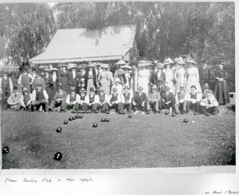 Clunes Museum
Photograph, ROGER PURCELL, CIRCA 1900
ORIGINAL PHOTOGRAPH PROPERTY OF MR. WILLIAM HARRIS OF SUTHERLAND STREET CLUNES.BLACK & WHITE COPY OF ORIGINAL PHOTOGRAPH - GROUP OF MEN AND WOMEN ASSEMBLED AT EDGE OF BOWLING GREEN AT CLUNES BOWLING CLUB WITH BUILDING BEHIND. ORIGINAL PHOTO MADE BY HORNBY PHOTOGRAPHERS OF CLUNES.ON ORIGINAL "CLUNES BOWLING CLUB MID 1920? "HORNBY CLUNES" ON BACK "H. BARKELL CLUNES" "V. B. OWENS FRASER STREET CLUNES"local history, photography, photographs, sport, bowling club clunes -
 Port Melbourne Historical & Preservation Society
Photograph - 64 Evans Street, Port Melbourne, Jack GOULD, c. 1950
This was the second house built by Caleb Kennett on this site. His was the first house in Evans Street, 1868. At turn of 21st century, home of Jenny and Noel Turnbull. Copied from Gould collection.Lasercopy of photo of 64 Evans Street and surrounding area (bird's eye view), originally home of abattoir owner Caleb Kennett..built environment - domestic, caleb kennett, noel turnbull, jenny turnbull, jack gould -
 Clunes Museum
Photograph
FRASER STREET, CLUNES.1 BLACK AND WHITE PHOTOGRAPH OF SHOPS IN FRASER STREET CLUNES-GILL & McDONALD FAMILY BUTCHERS, CLUNES TEA ROOMS AND NEWSAGENCY. .2 BLACK AND WHITE COPY OF PHOTOGRAPH PRINTED ON GLOSS PHOTOGRAPHIC PAPERlocal history, photography, photographs, shops, gill & mcdonald family butchers, clunes tea rooms, newsagent., clunes township -
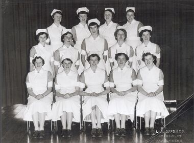 Northern District School of Nursing. Managed by Bendigo Historical Society Inc.
Photograph - Preliminary Training School 28
The Northern District School of Nursing opened in 1950 in to address the issues around nurse recruitment, training and education that had previously been hospital based. The residential school was to provide theoretical and in-house education and practical training over three years. The students would also receive practical hands-on training in the wards of associated hospitals. The Northern District School of Nursing operated from Lister House, Rowan Street, Bendigo. It was the first independent school of nursing in Victoria and continued until it closed in 1989. Black and white photograph of fourteen PTS 28 nurses. Photo taken 19th October, 1955Photographers stamp bottom R corner L.A. Hughes Hight Street Eaglehawkfourteen pts nurses photo, taken 19th october 1955 -
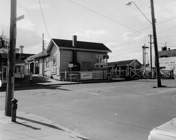 City of Kingston
Photograph - Black and white, c. 1969
Black and white photograph of level crossing gates and railway station at Bentleigh at the intersection of Burgess Street and Centre Road. This image is part of a larger collection of images from the Public Transport Corporation displaying train stations and streetscapes in what is now the City of Kingston.Black and white photograph of level crossing gates and railway station at Bentleigh at the intersection of Burgess Street and Centre Road.Stamped in blue ink on reverse: COPYRIGHT / Public Transport Corporation / For re-ordering photographs / Please quote negative No H3405 / Enquiries C/- PTC Photographic Unit / Telephone switchboard 619 111 White paper adhered to reverse of photograph with black typed text: Railway gates, Centre Road Bentleigh / 1969 / $50 reproduction fee appliesbentleigh, railway station, railway crossing, suburbs, public transport