Showing 5537 items matching "surrey road"
-
 Whitehorse Historical Society Inc.
Photograph, Mitcham, Surrey England, 1900
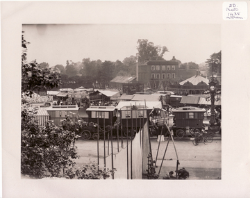
Black and white photo of Mitcham Fair on Fair Green by Thos. Francis, London House, Mitcham, England. 1900. The photo overlaps and give a panorama of the Fair as far as could been seen from Ravensbury House (J.D.Drewett). See NP1438mitcham, england -
 Whitehorse Historical Society Inc.
Photograph, Mitcham, England, 1900
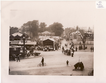
... Whitehorse Historical Society Inc. 2-10 Deep Creek Road ...Black and white photo of Black and white photo of Mitcham Fair on Fair Green by Thos. Francis, London House, Mitcham, England. 1900. The photo overlaps and give a panorama of the Fair as far as could been seen from Ravensbury House (J.D.Drewett). See NP1437mitcham, surrey, england -
 Whitehorse Historical Society Inc.
Document, Slater Family, 05/03/1996 and/12/1994
William Henry Slater of Mitcham, Surrey : an Australian pioneer. Notes by Eric Montague 05/03/1996 with an article ' A Mitcham Life' by Paul Parry from 'Merton Messenger' December 1994 on members of the Slater family, lavender growers.William Henry Slater of Mitcham, Surrey : an Australian pioneer. Notes by Eric Montague 05/03/1996 with an article ' A Mitcham Life' by Paul Parry from 'Merton Messenger' December 1994 on members of the Slater family, lavender growers. Includes photograph of William Mitchell. Note: Article refers also to Mitcham England. The photo of the Mayor Lyndon Parnell refers to Mitcham, South Australia.William Henry Slater of Mitcham, Surrey : an Australian pioneer. Notes by Eric Montague 05/03/1996 with an article ' A Mitcham Life' by Paul Parry from 'Merton Messenger' December 1994 on members of the Slater family, lavender growers.herb farms, slater, william henry, mitcham, slater, benjamin, skater, daniel, mitcham, surrey, england -
 Whitehorse Historical Society Inc.
Newspaper - Article, Lois Snibson, 2018
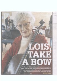
Lois Snibson is a 91 year old Cellist with the Surrey Hills Orchestra.Lois Snibson is a 91 year old Cellist with the Surrey Hills Orchestra and has been involved with the Whitehorse Musical Theatre.Lois Snibson is a 91 year old Cellist with the Surrey Hills Orchestra. snibson, lois, whitehorse musical theatre -
 Whitehorse Historical Society Inc.
Photograph - Postcard and photograph, Blackburn Road Looking South, 1917 or 1908
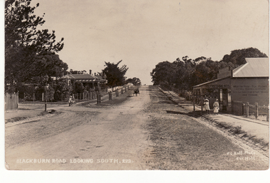
Black and white postcard and large photograph of old scene of Blackburn looking south. Figures of 3 children and horse and cart in scene.(on back) Addressed to - Mrs. Hilliard, 'Home' Windsor Crescent, Surrey Hillshilliard, mrs, blackburn road -
 Whitehorse Historical Society Inc.
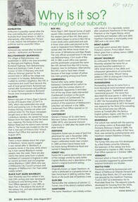
Article, Why Is It So?
How the eastern suburbs were named.ashburton, ashwood, ballyshanassy, balwyn, blackburn, black flat, box hill, burwood, camberwell, canterbury, deepdene, forest hill, glenferrie, glen iris, glen waverley, hawthorn, mont albert, mount waverley, nunawading, riversdale, surrey hill, vermont, wattle park -
 Whitehorse Historical Society Inc.
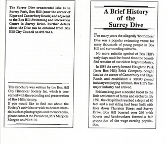
Pamphlet, A Brief history of Surrey Dive, n.d
Copy of a brochure issued by the Box Hill City Historical Society Inc. entitled 'A brief history of Surrey Dive', Box Hill.swimming pools, surrey dive, box hill, haughton park brick company, box hill brick company, standard brick company, surrey park, whitehorse aquatic and leisure centre -
 Whitehorse Historical Society Inc.
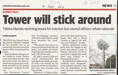
Article, Tower Will Stick Around, 2016
Telstra has blamed rezoning and an extended setback for its decision not to go ahead with the removal of the Surrey Hills communication tower but council officers refute rationale.telstra, city of whitehorse, surrey hills -
 Whitehorse Historical Society Inc.
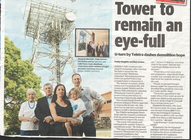
Article, Tower to Remain, 2016
Telstra has confirmed that the 53 year old Communications Tower at Surrey Hills will remain and not demolished, much to the disappointment of the nearby residents.telstra, city of whitehorse -
 Whitehorse Historical Society Inc.
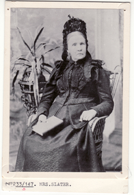
Photograph, Mrs. Slater
Mrs Slater and her husband William Slater migrated from Mitcham, Surrey, England in 1855 and established a herb farm in Nunawading - the first in Victoria. The farm was located in Blackburn Road, North Blackburn. When Mrs Slater died in 1895 the farm was sold. Slater Avenue and Slater Reserve is named for them.3 copies of Black and white photo of Mrs. Slaterslater, william, mrs, herb farms, slater avenue, blackburn north, slater reserve -
 Whitehorse Historical Society Inc.
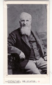
Photograph, William Slater
Mrs Slater and her husband William Slater migrated from Mitcham, Surrey, England in 1855 and established a herb farm in Nunawading - the first in Victoria. The farm was located in Blackburn Road, North Blackburn. When Mrs Slater died in 1895 the farm was sold. Slater Avenue and Slater Reserve is named for them.4 copies of black and white photo of William Slaterpioneers, slater, william, herb farms, slater avenue, blackburn north, slater reserve -
 Whitehorse Historical Society Inc.
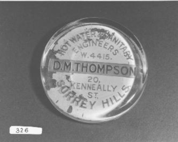
Functional object - Paperweight
Would have been used for Advertising or as gifts for customersGlass paperweight - Paper with advertising detail pasted on backHot Water and Sanitary Engineers W4415 D.M. Thompson, 20 Kenneally St., Surrey Hillscommerce, office equipment / stationery -
 Whitehorse Historical Society Inc.
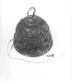
Container - String Dispenser
Collected by Harold Bakes from a shop (Eileen Conlon's) in Surrey Hills.Small ornate bell shaped metal container with a hole at side which string protudes. Cotton stored inside. Decorations include 'Mathews, Marcus, Lucas. Johannes. Handle.handcrafts, equipment -
 Whitehorse Historical Society Inc.
Article, Off-lead Dog Areas, Sep 2023
Ten newly declared off-lead areas are now available for dog walkersnon-fictionTen newly declared off-lead areas are now available for dog walkersbennettswood reserve, east burwood reserve, eley park (north), elgar park, junction road reserve, koonung reserve, slater reserve, springfield reserve, surrey park, whitehorse reserve -
 Whitehorse Historical Society Inc.
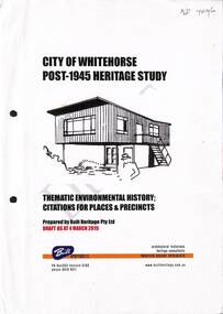
Book - Heritage Study, City Of Whitehorse Post-1945 Heritage Study, 4 March 2015
City of Whitehorse Post-1945 Heritage Study, dated 4 March 2015A4, 285 pages. A draft copy of the City of Whitehorse Post-1945 Heritage Study, dated 4 March 2015 (on front page) plus published copy of Appendix 2 pages 275-285non-fictionCity of Whitehorse Post-1945 Heritage Study, dated 4 March 2015 city of whitehorse, post war buildings, built heritage pty ltd, historic buildings, post war development, houses, architectural styles -
 Whitehorse Historical Society Inc.
Document, The Development of Local Health Services, 2017
A history of the development of local health servicesAn A4 document of 10 pages A history of the development of local health servicesdoctors, health professionals, slater william henry, infant welfare centres, pioneers, fitzmaurice a yvonne, delany's hotel surrey hills, hospitals, threlkeld verner w dr, cochrane stanley dr, mitcham private hospital, health centres, bellbird private hospital, nurses, peter james centre, toogood edith, health services -
 Whitehorse Historical Society Inc.
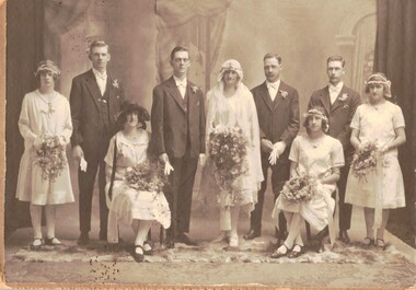
Photograph - Black and white photograph, Edwards/Hodge wedding 1926, 1926
Alfred Ernest Edwards was born 29/12/1903 in Mitcham and died 4/7/1967 at Forest Hill. he was a kiln worker at Geal's Pottery, Nunawading. Doris Gwendoline was born in 1905 at Surrey Hills and died on 15/3/1996 in a Healesville nursing home. She was 91. When Doris two her father died. Her mother remarried (Finger) and she had two step-sisters. Alfred (Alf) and Doris (Dorrie) had one child, Gwendoline Norma Edwards, born on 3/10/1930 at Forest Hill.Sepia studio photograph of the wedding of Alfred Ernest Edwards and Doris Gwendoline Hodge in 1926. There are nine people in the group. The bride and groom are in the centre; the man on the left is Alfred's brother Theodore and the woman seated on the left is Doris' Half -sister Jean (Finger)edwards, alfred ernest. hodge, doris gwendoline. edwards, theodore. finger, jean -
 Whitehorse Historical Society Inc.
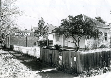
Photograph, Watts' Blackburn Dairy, c1929
The Watts family bought the dairy at 20 Albert St. in 1929 and increased the business from one to seven carts. From Albert St. they moved to Rialway Parade. In the beginning their milk came from a family dairy farm located in Moorabbin but after the Government required all milk to be pasteurised they obtained their milk from Crumps' dairy in Surrey Hills as was more efficientBlack and white photograph of the house and dairy belonging to the Watts family. House painted white and the dairy on the side of the brick building.dairies, watts' blackburn dairy, railway parade blackburn, watts don -
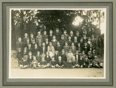 Mt Dandenong & District Historical Society Inc.
Photograph, Mt Dandenong School 3284 1942, 1942
Formal school photograph of the students at Mt Dandenong State School taken in 1942. Mounted on stiff cardboard.Handwritten on back of photograph: Betty Jeeves (Law Smith) 1st right middle row Stamp G. E. Hains Photographer 654 CANTERBURY Rd. SURREY HILLS, E10mt dandenong school, betty jeeves, elizabeth law smith -
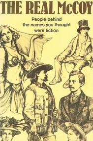 Otway Districts Historical Society
Book, Reader's Digest Services Pty Limited, The real McCoy, 1984
All the names in this book are familiar and most of them slip into general conservation without a thought being given to the fact that they belong to real people. The real McCoy who gave his name to this expression was Norman Selby, a boxer born in Rush County, Indiana, in the United States, who changed his name on boxing to Charles 'Kid' McCoy to have a 'better' Irish name.The real McCoy. People behind the names you thought were fiction. Eileen Hellicar. 1st ed. Reader's Digest Services Pty Limited; Surrey Hills (NSW); 1984. 52 p.; illus. Soft cover. ISBN 0 949819 55 7 mccoy; norman selby; eileen hellicar; -
 Bayside Gallery - Bayside City Council Art & Heritage Collection
Map, H.B. Foot, Plan of the Brighton Estate containing 5120 acres, first special survey at Port Phillip, c. 1842
This plan records the Brighton Estate, also known as Dendy's Special Survey. In 1840 Henry Dendy, a farmer in Surrey, England acquired a "Special Survey" from the Commissioners for Land and Emigration which gave him the right to choose land in Port Phillip for the low price of £1 per acre for 5120 acres. Dendy appointed Jonathan Binns Were, as his agent, who later became a partner. Together, Dendy and Were decided on an area 5 miles south from Melbourne, bounded by North Road, East Boundary Road, South Road and to the west by Port Phillip Bay. Their Brighton Estate was first surveyed by T. S. Townsend in May 1841 and was re-surveyed by Robert Hoddle. Dendy and Were were making plans to sell the land and advertised a 30-guinea prize for the best subdivision which was to be divided into a village, marine residences, suburban and cultivation allotments, with the remainder being divided into country sections. The competition was won by H.B. Foot, who planned the village around a reserve and crescents and a 'green belt' forming the town boundary. brighton estate, dendy's special survey, special survey, henry dendy, jonathan binns were, w.b. were, survey, plan, map, brighton, george ward cole, baker's lithographer, hibernian, subdivision, town planning, cartographic material, h.b. foot -
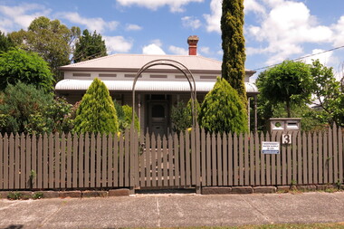
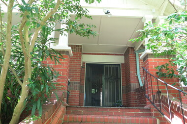
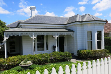
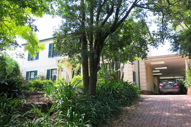
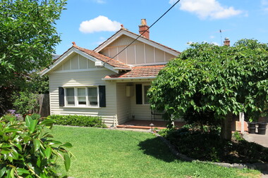
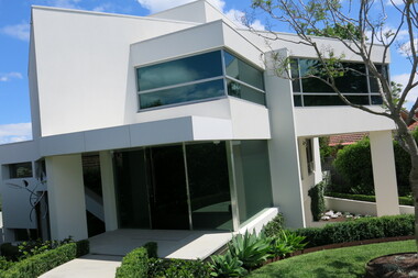
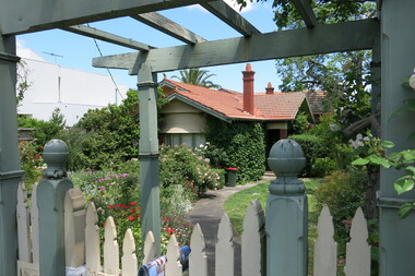
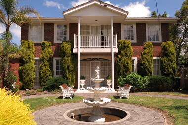 Surrey Hills Historical Society Collection
Photograph - 1 St Georges Avenue, Mont Albert, The Street Where You Live Project
Photos documenting this address as part of a photographic series undertaken by volunteer photographers during 2013 and 2014 for The Street Where You Live Project. This was organised through the Surrey Hills Neighbourhood Centre and covered the postcode 3127 in the cities of Boroondara and Whitehorse.These photos provide a snapshot of real estate in the suburbs of Mont Albert and Surrey Hills during a period of rapid change with many properties on large blocks demolished to create higher density residential development or renewal of single dwellings. At particular risk were properties not covered by heritage overlays, in particular interwar housing and post 1950's housing. -
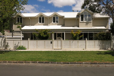 Surrey Hills Historical Society Collection
Photograph - 1A St Georges Avenue, Mont Albert, The Street Where You Live Project
Photos documenting this address as part of a photographic series undertaken by volunteer photographers during 2013 and 2014 for The Street Where You Live Project. This was organised through the Surrey Hills Neighbourhood Centre and covered the postcode 3127 in the cities of Boroondara and Whitehorse.These photos provide a snapshot of real estate in the suburbs of Mont Albert and Surrey Hills during a period of rapid change with many properties on large blocks demolished to create higher density residential development or renewal of single dwellings. At particular risk were properties not covered by heritage overlays, in particular interwar housing and post 1950's housing. -
 Surrey Hills Historical Society Collection
Photograph - 3 St Georges Avenue, Mont Albert, The Street Where You Live Project
Photos documenting this address as part of a photographic series undertaken by volunteer photographers during 2013 and 2014 for The Street Where You Live Project. This was organised through the Surrey Hills Neighbourhood Centre and covered the postcode 3127 in the cities of Boroondara and Whitehorse.These photos provide a snapshot of real estate in the suburbs of Mont Albert and Surrey Hills during a period of rapid change with many properties on large blocks demolished to create higher density residential development or renewal of single dwellings. At particular risk were properties not covered by heritage overlays, in particular interwar housing and post 1950's housing. -
 Surrey Hills Historical Society Collection
Photograph - 4 St Georges Avenue, Mont Albert, The Street Where You Live Project
Photos documenting this address as part of a photographic series undertaken by volunteer photographers during 2013 and 2014 for The Street Where You Live Project. This was organised through the Surrey Hills Neighbourhood Centre and covered the postcode 3127 in the cities of Boroondara and Whitehorse.These photos provide a snapshot of real estate in the suburbs of Mont Albert and Surrey Hills during a period of rapid change with many properties on large blocks demolished to create higher density residential development or renewal of single dwellings. At particular risk were properties not covered by heritage overlays, in particular interwar housing and post 1950's housing. -
 Surrey Hills Historical Society Collection
Photograph - 5 St Georges Avenue, Mont Albert, The Street Where You Live Project
Photos documenting this address as part of a photographic series undertaken by volunteer photographers during 2013 and 2014 for The Street Where You Live Project. This was organised through the Surrey Hills Neighbourhood Centre and covered the postcode 3127 in the cities of Boroondara and Whitehorse.These photos provide a snapshot of real estate in the suburbs of Mont Albert and Surrey Hills during a period of rapid change with many properties on large blocks demolished to create higher density residential development or renewal of single dwellings. At particular risk were properties not covered by heritage overlays, in particular interwar housing and post 1950's housing. -
 Surrey Hills Historical Society Collection
Photograph - 6 St Georges Avenue, Mont Albert, The Street Where You Live Project
Photos documenting this address as part of a photographic series undertaken by volunteer photographers during 2013 and 2014 for The Street Where You Live Project. This was organised through the Surrey Hills Neighbourhood Centre and covered the postcode 3127 in the cities of Boroondara and Whitehorse.These photos provide a snapshot of real estate in the suburbs of Mont Albert and Surrey Hills during a period of rapid change with many properties on large blocks demolished to create higher density residential development or renewal of single dwellings. At particular risk were properties not covered by heritage overlays, in particular interwar housing and post 1950's housing. -
 Surrey Hills Historical Society Collection
Photograph - 7 St Georges Avenue, Mont Albert, The Street Where You Live Project
Photos documenting this address as part of a photographic series undertaken by volunteer photographers during 2013 and 2014 for The Street Where You Live Project. This was organised through the Surrey Hills Neighbourhood Centre and covered the postcode 3127 in the cities of Boroondara and Whitehorse.These photos provide a snapshot of real estate in the suburbs of Mont Albert and Surrey Hills during a period of rapid change with many properties on large blocks demolished to create higher density residential development or renewal of single dwellings. At particular risk were properties not covered by heritage overlays, in particular interwar housing and post 1950's housing. -
 Surrey Hills Historical Society Collection
Photograph - 9 St Georges Avenue, Mont Albert, The Street Where You Live Project
Photos documenting this address as part of a photographic series undertaken by volunteer photographers during 2013 and 2014 for The Street Where You Live Project. This was organised through the Surrey Hills Neighbourhood Centre and covered the postcode 3127 in the cities of Boroondara and Whitehorse.These photos provide a snapshot of real estate in the suburbs of Mont Albert and Surrey Hills during a period of rapid change with many properties on large blocks demolished to create higher density residential development or renewal of single dwellings. At particular risk were properties not covered by heritage overlays, in particular interwar housing and post 1950's housing. -
 Surrey Hills Historical Society Collection
Photograph - 11 St Georges Avenue, Mont Albert, The Street Where You Live Project
Photos documenting this address as part of a photographic series undertaken by volunteer photographers during 2013 and 2014 for The Street Where You Live Project. This was organised through the Surrey Hills Neighbourhood Centre and covered the postcode 3127 in the cities of Boroondara and Whitehorse.These photos provide a snapshot of real estate in the suburbs of Mont Albert and Surrey Hills during a period of rapid change with many properties on large blocks demolished to create higher density residential development or renewal of single dwellings. At particular risk were properties not covered by heritage overlays, in particular interwar housing and post 1950's housing.