Showing 1846 items
matching town centre
-
 Brighton Historical Society
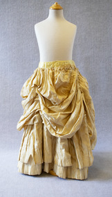
Skirt, Child's crinoline skirt, circa 1855-60
... and Cultural Centre (Old Brighton Town Hall) Corner Carpenter ...This child's crinoline skirt was donated in 1974 by Mrs Ella Kohn of Were Street, a life member of the Society. According to then-BHS Secretary Rosalind Landells, the skirt was originally made the fit a girl aged 10-12, but had been modified to add length. Mrs Landells reported that Society members had restored the skirt to the original length and that it would be worn at a costume parade at the Southern Cross on 27 March 1974 by Carolyn Scott.Pale yellow silk half-hoop skirt with cotton lining. Layered skirt with ruched top layer.children's clothing, crinoline, 1850s, 1860s, ella kohn -
 Brighton Historical Society
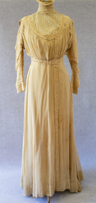
Dress, Professional & Civil Service Supply Association, circa 1900
... and Cultural Centre (Old Brighton Town Hall) Corner Carpenter ...Unknown provenance.Coffee-coloured cotton and chiffon evening gown. Net yoke with vertical pintucks and high neck. Pintucked bodice. Trim of meadering cream cord bordered on either side, around yoke, waist, shoulders, cuffs and down centre of skirt. Printed on interior of bodice: "Professional & Civil Service Supply Association / 80 George Street Edinburgh".Printed on interior of bodice: "Professional & Civil Service Supply Association / 80 George Street Edinburgh".1900s -
 Port Fairy Historical Society Museum and Archives
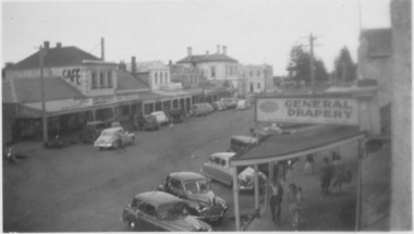
Photograph
Centre of Sackville Street possible dates 1940’s-50’sBlack and white photograph of centre of Sackville street with general Drapery sign on right and cafe sign on building on the leftstreet, town, sackville st, cars, drapery, cafe -
 Port Fairy Historical Society Museum and Archives
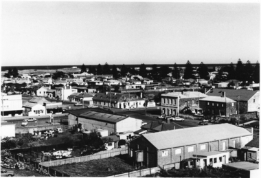
Photograph
SE view from St Johns Tower 1973Black and white photograph of aerial view Caledonian & Victoria Hotels centre. Reardon theatre far leftst john's tower, tower, st johns, town, aerial, caledonian, victoria, hotel -
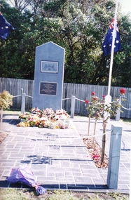 Port Fairy Historical Society Museum and Archives
Photograph
... This Soldiers Memorial was erected in the centre... was erected in the centre of the town as the original Memorial stands ...This Soldiers Memorial was erected in the centre of the town as the original Memorial stands at the top of the hill on the busy Princes Highway. This made the site difficult to police and march to because of the traffic passing through the town.Coloured photograph of Soldier’s memorial with flowers during Anzac Daymemorial, bank street, railway place, soldier -
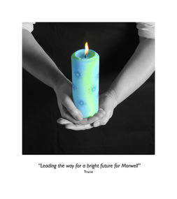 Federation University Art Collection
Photograph, Clive Hutchison, 'Our Hopes and Future of Morwell' Photographic Collection, 2017
This photographic exhibition was developed by the Federation University-led Community Wellbeing research stream of the Hazelwood Health Study in collaboration with Morwell Neighbourhood House and Gippsland Centre for Art and Design at Federation University Australia. It highlights people's hopes for the future of Morwell has its roots in two unexpected places: the Hazelwood mine fire in 2014 and an academic study into community recovery from that fire. In late summer of 2014 a bushfire spread to the coal mine near the town of Morwell in the LaTrobe Valley, in south-eastern Victoria. The Hazelwood mine fire burned for 45 days, shrouding communities - especially Morwell - in smoke and ash. Strong calls by the community for an investigation into the health impacts of the Hazelwood Mine Fire led to the Department of Health's (Know the Department of Health and Human Services) decision to fund a ten year study of the potential health effects of this smoke event (Known as the Hazelwood Health Study). This exhibition came out of work undertaken by the Community Wellbeing Stream of the Hazelwood Health Study during 2016 and 2017. Based at Federation University Australia's Gippsland Campus, just a few kilometres from where the fire took place, one of our Study's main aims has been to find out from the community how the smoke event impacted on community wellbeing. We also planned to talk to community members about the effectiveness of community rebuilding activities, and find our how these have aided recovery following the smoke event. In 2017 we began working with community organisations on a project to foster community recovery and wellbeing. What emerged from these discussions was the idea for a photographic exhibition, on the theme of 'Our hopes for the future of Morwell'. Invitations to participate were extended to up to 50 members of various community groups. The groups were asked to think of some object that symbolizes their hopes for the future of Morwell. Individuals were then invited to attend a photographic session kindly hosted by the Morwell Neighbourhood House. Each individual was to hold this object while it was photographed, as well as explain what the object represented in terms of Morwell's future. Out of this process twenty nine photographs with their captions were produced, enlarged and framed for exhibiting. The photographs were taken by Clive Hutchison of the Gippsland Centre for Art and Design at Federation University Australia.Twenty nine framed original photographs.morwell, our hopes for the future of morwell, clive hutchison, photography, morwell neighbourhood house, hazelwood health service, gippsland centre for art and design, hazelwood mine fire, haxelwood health study, morwell neighbourhood mine fire, neale stratford, tracie lund, ian brown, susan yell, sue whyte, ainsley ja, ainsley james, michelle duffy, shaun mallia, valerie prokopiv, morwell art and framing -
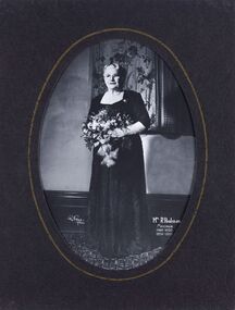 City of Greater Bendigo - Civic Collection
Photograph - Portrait, Reg V Brock, Mrs R. Poulston Mayoress 1949 - 50, 1954 - 55, c 1950
Prior to the election of female Councillors and Mayors in the 1960’s, The Lady Mayoress role was one of the few ways women could officially undertake civic duties. Mayoresses made important contributions to their local communities through their charity work and as ambassadors for their region on a state and federal level. They also undertook some Mayoral duties on occasions if if their husband was unavailable. Mayoress Poulston was born Dora Isobel Morgan and was actively associated with many charities including the Baby Health Centre. Mayoress Poulston died in 1965 aged 75 and was born and lived her entire life in the district. Framed, oval photographic studio portrait. Hand coloured detail.ll, Reg Brock / of Bendigo. lr, Mrs R. Poulston / Mayoress / 1949 - 1950 / 1954 - 1955dora morgan, dora poulston, reg brock photographer, robert poulston, city of bendigo mayoress, city of greater bendigo portrait -
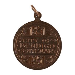 City of Greater Bendigo - Civic Collection
Medal - City of Bendigo Centenary Medal, Stokes and Son
Medal commemorating the centenary of the establishment of a settlement on Bendigo Creek. Stokes & Sonsobverse; 1851 / City of Bendigo Centenary / 1951. Reverse: In centre: Coat of arms (Bendigo), Below Progresscity of greater bendigo medals -
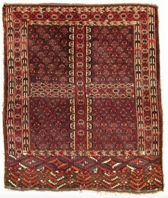 City of Greater Bendigo - Civic Collection
Textile - Yomut Turkmen Islamic Rug, c 1880
This rug was a gift and gesture of friendship from the local Muslim community to the City of Greater Bendigo. It was presented to Mayor, Cr Rod Fyffe on behalf of the people of Bendigo at a 2016 'Thank You Bendigo' dinner. In 2014 approval for a planning application from the Bendigo Islamic Association to build a community centre and mosque in East Bendigo prompted a series of public protests that captured widespread media attention. During this tumultuous period the Council identified the need for a community-wide plan to promote diversity and help address potentially divisive cultural issues. These events led to the COGB becoming the first local government area (LGA) formally accredited under Australia’s Welcoming Cities Standard. Community leaders emerged who wanted to show that the anti-mosque protesters did not reflect the views of the majority of Bendigo residents. The community lead ‘Believe in Bendigo’ movement gained momentum, and the Council and other local organisations joined forces to present a unified message that Bendigo residents do not tolerate racism. Muslims have made Central Victoria their home since the Goldrush, contributing to the community and the economy for the past 120 years. Traditional Islamic rugs, especially their patterns and motifs are intrinsically linked with the design of the Bendigo Mosque and Bendigo Islamic Community Centre providing important points of reference for the architects of the project. Typically, mosques are linked with specific cultural groups but not in the case of Bendigo where the Muslim community is made up of multi-ethnic groups. This meant the building's design was not fixed to a specific style or cultural iconography but instead needed to encompass many. The small local Muslim community selected a specific Australian architect because of their interest and knowledge of Islamic design and iconography gained through family collection of Islamic textiles. In thinking about the design of the mosque and community centre the architects wanted to acknowledge the role of Afghans in Australian history, especially tribal Afghans who helped build connections across the interior of Australia between First Nations communities, European settlers and Central Asian migrants. The gift of this Turkmen rugto the Bendigo community thus symbolises collaborative partnerships across faith and cultural groups based on friendship and mutual benefit. A Turkman rug was specifically chosen as it is the pinnacle of nomadic arts of the Islamic world. It was also important to the architects and the local Muslim community that the gift was a female artistic product as it was mainly a female Muslim architecture team that designed the mosque in Bendigo and there was a desire to select something that celebrated female artistry. This hand-woven rug is an engsi, made for a woman in preparation for marriage. Design work and weaving is a shared experience, between many generations of women and each rug hold the personal story of the woman it is made for and her family and thus holds deep symbolic meaning. There are often songs and poetry that are recited as the rug is made – helping the makers to memorisze the mathematical structure of the design. An engsi is put on the doorway to a yurt as part of a wedding ceremony. During the ceremony the groom turns the engsii upside down to check the quality of the rug makers weaving skills. The nomadic lifestyle of Yomut Turkman tribes determines the size of the rug as the loom can’t be carried. Its size is also restricted by the dimensions of the doorway of the yurt. This rug is dated as c 1880 because of the types of patterns used, the use of natural dyes (synthetic dyes were introduced to the area in 1890s) and with the smoother weaving on the back indicating the quality of craftsmanship dating to this time period. The Yomut engsi rug was made in Turkmenistan c1880 by Yomut Turkmen Tribes people and is designed to fit over the doorway of a yurt during a wedding ceremony. The main field motif is related to Turkoman jewelery design. The women and girls of the tribe spin the wool and design and weave the rugs. The men shear the sheep, dye the wool and clip the rug after it has been woven. The word “Turkoman” is thought to have been derived from Turk-iman, meaning the first nomadic Turkic tribes that began to follow Islam. Dyes used are natural including orange from madder root. bendigo mosque, bendigo islamic association, city of greater bendigo community partnerships, city of greater bendigo community groups -
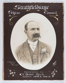 City of Greater Bendigo - Civic Collection
Photograph - Portrait of Councillor Keck, W H Robinson, c 1913
The district of Strathfieldsaye was proclaimed in 1861 and named a Shire on the 17th September in 1866. It remained a shire until amalgamation in 1994 when it became part of the City of Greater Bendigo. The shire was located 8 km to the south- east of Bendigo and covered an area of 601 square kilometres and extended from the Calder Highway to the Coliban and Campaspe Rivers. The shire's administration centre was in Strathfieldsaye until 1972 when new offices were opened in Kennington.Framed black and white head and shoulder portrait of Councillor Keck with hand coloured and drawn detail. Profile slightly to right with walrus moustache. Cut oval brown mount decorated with text and flowers. Hand written title top and lower centre.Strathfieldsaye / Shire Council / W.H. Robinson / Photo / Bendigo / J.H.E Gribbs / Presented by / Cr Herbert Keck / President 1903-4. 1912-13.shire of strathfieldsaye, councillor keck, strathfieldsaye shire council, president of strathfieldsaye shire -
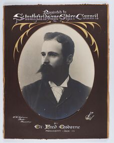 City of Greater Bendigo - Civic Collection
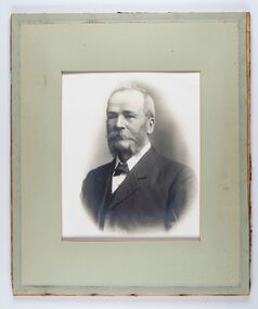
Photograph - Portrait of Councillor Osbourne, W H Robinson, C 1910
Framed black and white head and shoulder portrait of Councillor Osbourne with hand coloured and drawn detail. Left facing profile with walrus moustache. Cut oval brown mount decorated with text ornate border. Hand written title top and lower centre.Presented to Strathfieldsaye Shire Council / W.H. Robinson / Photo / Bendigo / J.H.E Gribbs / by / Cr Fred Osborne / President 1909-10shire of strathfieldsaye, president of strathfieldsaye shire, councillor fred osborne, strathfieldsaye shire council -
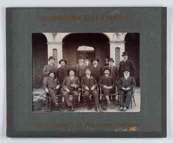 City of Greater Bendigo - Civic Collection
Photograph - Councillor group portrait, W H Robinson, Strathfieldsaye Shire Council, 1909
The district of Strathfieldsaye was proclaimed in 1861 and named a Shire on the 17th September in 1866. It remained a shire until amalgamation in 1994 when it became part of the City of Greater Bendigo. The shire was located 8 km to the south- east of Bendigo and covered an area of 601 square kilometres and extended from the Calder Highway to the Coliban and Campaspe Rivers. The shire's administration centre was in Strathfieldsaye until 1972 when new offices were opened in Kennington.Photographic group portrait of eleven Strathfieldsaye Shire Councillors in front of the Strathfieldsaye Shire Hall. Five men are seated and six standing with one man standing further in back ground on the building's verandah. Photograph is attached directly to green mount card and framed. Gold lettering on mount.Strathfieldsaye Shire Councillors / R. B. Brennan (Sec.) W. J. Lowdes S. Doak M. Burns () N Condon B. Code (Inspector) / WH Robinson Photo Bendigo / T Somerville / W. I. Long / Fred Osborne (President) H Keck / W Dresler / With the President's (Cr. Fred Osborne) Compliments / September 23rd, 1909shire of strathfieldsaye, strathfieldsaye shire council, president of strathfieldsaye shire, strathfieldsaye shire hall -
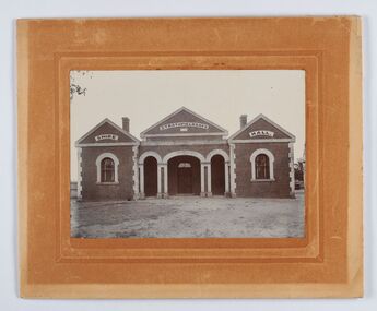 City of Greater Bendigo - Civic Collection
Photograph - Strathfieldsaye Shire Hall
The district of Strathfieldsaye was proclaimed in 1861 and named a Shire on the 17th September in 1866. It remained a shire until amalgamation in 1994 when it became part of the City of Greater Bendigo. The shire was located 8 km to the south- east of Bendigo and covered an area of 601 square kilometres and extended from the Calder Highway to the Coliban and Campaspe Rivers. The shire's administration activities were centred at the Strathfieldsaye Shire Hall which was built in 1869 at a cost of £700 based on a design by George Steane, the shire surveyor and built by George Pallett of Sandhurst. Constructed of red brick, the hall has a unique ventilation system with hollow walls open at the top and bottom to ensure a draught to cool the building in summer. Framed and mounted photograph of the Strathfieldsaye Shire Hall. Verso; W M Robinson / Photographer / Mundy Street Bendigostrathfieldsaye shire hall, shire of strathfieldsaye, strathfieldsaye shire council -
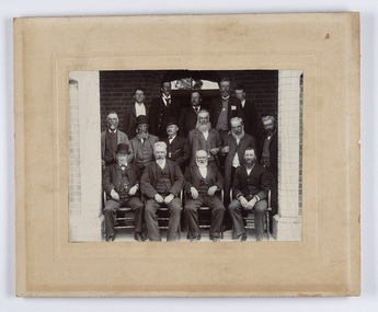 City of Greater Bendigo - Civic Collection
Photograph - Strathfieldsaye Councillor Group Portrait, D.G. Coope & Son - Framers
The district of Strathfieldsaye was proclaimed in 1861 and named a Shire on the 17th September in 1866. It remained a shire until amalgamation in 1994 when it became part of the City of Greater Bendigo. The shire was located 8 km to the south- east of Bendigo and covered an area of 601 square kilometres and extended from the Calder Highway to the Coliban and Campaspe Rivers. The shire's administration centre was in Strathfieldsaye until 1972 when new offices were opened in Kennington.Silver gelatin framed photographic group portrait of fifteen men taken in the alcove of the Strathfieldsaye Shire Hall. Four men are seated and eleven are standing. Photograph is attached directly to cream mount card. Handwritten note with photograph: 1/ John Burke, 2/ (?), 3/ (?), 4/ RHS Abbott, 5/ M Brennan, 6/(?) 7/(?) 1/. M Condon? 2/ (?) 3/ M Burns, 4/(?) Gentlemen at back probably are council staff.shire of strathfieldsaye, strathfieldsaye shire council, president of strathfieldsaye shire, councillor john burke, councillor r.h.s. abbott, councillor brennan, councillor condon, councillor m burns -
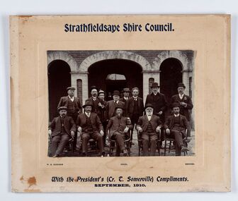 City of Greater Bendigo - Civic Collection
Photograph - Councillor group portrait, W H Robinson, Strathfieldsaye Shire Council
The district of Strathfieldsaye was proclaimed in 1861 and named a Shire on the 17th September in 1866. It remained a shire until amalgamation in 1994 when it became part of the City of Greater Bendigo. The shire was located 8 km to the south- east of Bendigo and covered an area of 601 square kilometres and extended from the Calder Highway to the Coliban and Campaspe Rivers. The shire's administration centre was in Strathfieldsaye until 1972 when new offices were opened in Kennington. Group portrait of 13 men / councilors, 5 seated and 8 standing dressed in suits. There are another 2 men further back in front of the hall doors. Photograph is taken outside the Strathfieldsaye Shire Hall.Srathfieldsaye Shire Council. / With the President's (Cr T. Somerville) Compliments. / September, 1910 / W.H. Robinson Photo. Bendigo Verso; William Drechslershire of strathfieldsaye, president of strathfieldsaye shire, strathfieldsaye shire council -
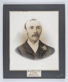 City of Greater Bendigo - Civic Collection
Photograph - Portrait of Councillor Orr, The Yeoman Studios, Ex. Councillor / F. Orr / Eppalock
The district of Strathfieldsaye was proclaimed in 1861 and named a Shire on the 17th September in 1866. It remained a shire until amalgamation in 1994 when it became part of the City of Greater Bendigo. The shire was located 8 km to the south- east of Bendigo and covered an area of 601 square kilometres and extended from the Calder Highway to the Coliban and Campaspe Rivers. The shire's administration centre was in Strathfieldsaye until 1972 when new offices were opened in Kennington. Eppalock Ward is one of three wards in the Greater Bendigo municipality which includes the former Strathfieldsaye Shire. Framed black and white head and shoulder portrait with hand coloured detail. Man with profile slightly to right, walrus moustache, image encircled. Photograph is attached to mount card. Hand written title lower centre.Ex. Councillor / F. Orr / Eppalock / The / Yeoman / Studiosshire of strathfieldsaye, councillor orr -
 City of Greater Bendigo - Civic Collection
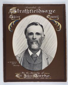
Photograph - Portrait of Councillor Burke
The district of Strathfieldsaye was proclaimed in 1861 and named a Shire on the 17th September in 1866. It remained a shire until amalgamation in 1994 when it became part of the City of Greater Bendigo. The shire was located 8 km to the south- east of Bendigo and covered an area of 601 square kilometres and extended from the Calder Highway to the Coliban and Campaspe Rivers. The shire's administration centre was in Strathfieldsaye until 1972 when new offices were opened in Kennington. Framed black and white head and shoulder portrait of Councillor Burke with hand coloured and drawn detail. Profile centre facing with beard. Cut oval brown mount decorated with text and fscrolls. Hand written title top and lower centre. Wooden frame with detail and gold inner.Presented to Strathfieldsaye / shire Council / w. H. robinson / Photo / Bendigo / By the family of / Cr John Burke / President 1890 - 1899 - 1900strathfieldsaye shire council, councillor burke, president of strathfieldsaye shire -
 City of Greater Bendigo - Civic Collection
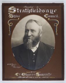
Photograph - Portrait of Councillor Thomas Somerville, W H Robinson
The district of Strathfieldsaye was proclaimed in 1861 and named a Shire on the 17th September in 1866. It remained a shire until amalgamation in 1994 when it became part of the City of Greater Bendigo. The shire was located 8 km to the south- east of Bendigo and covered an area of 601 square kilometres and extended from the Calder Highway to the Coliban and Campaspe Rivers. The shire's administration centre was in Strathfieldsaye until 1972 when new offices were opened in KenningtonFramed black and white head and shoulder portrait of Councillor Somerville with hand drawn detail. Profile slightly to left, face has full beard. Cut oval brown mount decorated with text and scrolls. Hand written title top and lower centre.Presented to / Strathfieldsaye / Shire Council / W. H. Robinson / Photo / Bendigo / by / Cr Thomas Somerville / President 1892 - 3. 1901.2. 1910.11 strathfieldsaye shire council, councillor somerville, president of strathfieldsaye shire -
 City of Greater Bendigo - Civic Collection
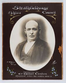
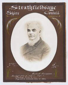
Photograph - Portrait of Councillor Michael Condon, W H Robinson
The district of Strathfieldsaye was proclaimed in 1861 and named a Shire on the 17th September in 1866. It remained a shire until amalgamation in 1994 when it became part of the City of Greater Bendigo. The shire was located 8 km to the south- east of Bendigo and covered an area of 601 square kilometres and extended from the Calder Highway to the Coliban and Campaspe Rivers. The shire's administration centre was in Strathfieldsaye until 1972 when new offices were opened in KenningtonFramed black and white head and shoulder portrait of Councillor Condon with hand coloured and drawn detail. Profile slightly to left. No facial hair. Cut oval brown mount decorated with text, scrolls and flowers. Hand written title top and lower centre.Strathfieldsaye / Shire / Council / W. H. Robinson / Photo / Bendigo / JMB Gribble / Presented by / Cr Michael Condon / President 1889 - 90. 1895-6. 1904 - 5strathfieldsaye shire council, president of strathfieldsaye shire, councillor condon -
 City of Greater Bendigo - Civic Collection
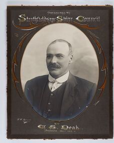
Photograph - Portrait of Councillor Doak, W H Robinson
The district of Strathfieldsaye was proclaimed in 1861 and named a Shire on the 17th September in 1866. It remained a shire until amalgamation in 1994 when it became part of the City of Greater Bendigo. The shire was located 8 km to the south- east of Bendigo and covered an area of 601 square kilometres and extended from the Calder Highway to the Coliban and Campaspe Rivers. The shire's administration centre was in Strathfieldsaye until 1972 when new offices were opened in Kennington.Framed black and white head and shoulder portrait of Councillor Doak with hand coloured and drawn detail. Left facing profile with walrus moustache. Cut oval brown mount decorated with text and scrolls. Hand written title top and lower centre.Presented to / Strathfieldsaye Shire Council / W. H. Robinson / Photo / JMB Gribble / by Cr S. Doak / President 1911 - 1912strathfieldsaye shire council, president of strathfieldsaye shire, councillor doak -
 City of Greater Bendigo - Civic Collection
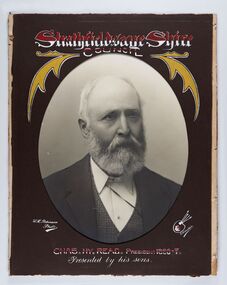
Photograph - Portrait of Councillor Read, W H Robinson
Framed black and white head and shoulder portrait of Councillor Read with hand coloured and drawn detail. Head profile facing right with beard. Cut oval brown mount decorated with text and scrolls. Hand written title top and lower centre.Strathfieldsaye Shire / Council / W H Robinson / Photo / J H Gribble / Chas. My. Read. President 1886 - 7 / Presented by his sonsstrathfieldsaye shire council, president of strathfieldsaye shire, president read -
 City of Greater Bendigo - Civic Collection
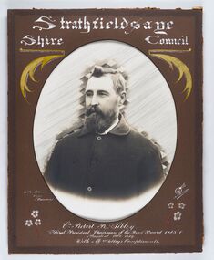
Photograph - Portrait of Councillor Sibley, W H Robinson
The district of Strathfieldsaye was proclaimed in 1861 and named a Shire on the 17th September in 1866. It remained a shire until amalgamation in 1994 when it became part of the City of Greater Bendigo. The shire was located 8 km to the south- east of Bendigo and covered an area of 601 square kilometres and extended from the Calder Highway to the Coliban and Campaspe Rivers. The shire's administration centre was in Strathfieldsaye until 1972 when new offices were opened in KenningtonFramed black and white head and shoulder portrait of Councillor Sibley with hand coloured and drawn detail. Profile slightly to left with walrus moustache and beard. Cut oval brown mount decorated with text, flowers and scrolls. Hand written title top and lower centre.Strathfieldsaye / Shire Council / W m Robinson / Photo / Bendigo / J N B Gribble / Cr Robert R Sibley / First President Chairman of the Road Board 1865 - 5 / President 1866 - 1869 / With Mrs Sibley's Complimentsstrathfieldsaye shire council, councillor sibley, president of strathfieldsaye shire -
 City of Greater Bendigo - Civic Collection
Photograph - Portrait of Councillor Brennan, W H Robinson
The district of Strathfieldsaye was proclaimed in 1861 and named a Shire on the 17th September in 1866. It remained a shire until amalgamation in 1994 when it became part of the City of Greater Bendigo. The shire was located 8 km to the south- east of Bendigo and covered an area of 601 square kilometres and extended from the Calder Highway to the Coliban and Campaspe Rivers. The shire's administration centre was in Strathfieldsaye until 1972 when new offices were opened in Kennington. Councillor Michael Brennan held roles of Shire Secretary and Clark of Works until around 1998 when his son R. B. Brennan was appointed Assistant Secretary and then Shire Secretary to assist his father with the work load during his later years. Michael Brennan remained Clerk of Works until his death at which time his son was appointed to the duties previously held by his father. Framed black and white head and shoulder portrait of Councillor Brennan with hand coloured and drawn detail. Profile to left. Cut oval brown mount decorated with text and flowers. Hand written title top and lower centreStrathfieldsaye / Shire Council / W H Robinson / Photo / Bendigo / J H B Gribble / Michael Brennan / President 1869 - 70. 1871 - 2. 1872 - 3 / Secretary 1882 to 1900 / Engineer & Valuator 1882 to 1902strathfieldsaye shire council, councillor brennan, president of strathfieldsaye shire -
 City of Greater Bendigo - Civic Collection
Photograph - Portrait of Councillor Long, Talma & Co
The district of Strathfieldsaye was proclaimed in 1861 and named a Shire on the 17th September in 1866. It remained a shire until amalgamation in 1994 when it became part of the City of Greater Bendigo. The shire was located 8 km to the south- east of Bendigo and covered an area of 601 square kilometres and extended from the Calder Highway to the Coliban and Campaspe Rivers. The shire's administration centre was in Strathfieldsaye until 1972 when new offices were opened in Kennington.Framed black and white head and shoulder portrait of Councillor Long. Profile to left with walrus moustache and mutton chops. Cut olive retangle mount. Verso; Long. On under board which has photograph attached; Talma & Co. / 119 Swanston St., / Melbournestrathfieldsaye shire council, councillor long -
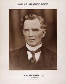 City of Greater Bendigo - Civic Collection
Photograph - Portrait of Shire Secretary Brennan, Unknown
The district of Strathfieldsaye was proclaimed in 1861 and named a Shire on the 17th September in 1866. It remained a shire until amalgamation in 1994 when it became part of the City of Greater Bendigo. The Shire was located 8 km to the south- east of Bendigo and covered an area of 601 square kilometres and extended from the Calder Highway to the Coliban and Campaspe Rivers. The shire's administration centre was in Strathfieldsaye until 1972 when new offices were opened in Kennington. Secretary Brennan, son of Councillor M. Brennan was appointed after his fathers death to the role and according to the The Bendigo Independent was in the role in 1917. See References.Framed black and white head and shoulder portrait of Councillor Brennan. Profile slightly to left. Cut rectangle cream mount. Hand written title top and lower centre. Shire of Strathfieldsaye / R. B. Brennan, Esq / Secretarystrathfieldsaye shire council, secretary strathfieldsaye shire -
 City of Greater Bendigo - Civic Collection
Photograph - Portrait of Councillor Hargraves, Bartlett Bros
The district of Strathfieldsaye was proclaimed in 1861 and named a Shire on the 17th September in 1866. It remained a shire until amalgamation in 1994 when it became part of the City of Greater Bendigo. The shire was located 8 km to the south- east of Bendigo and covered an area of 601 square kilometres and extended from the Calder Highway to the Coliban and Campaspe Rivers. The shire's administration centre was in Strathfieldsaye until 1972 when new offices were opened in KenningtonFramed black and white head and shoulder portrait of Councillor Hargraves. Profile slightly to right with walrus moustache. Cut rectangle brown mount decorated with coloured text and scrolls. Hand written title top and lower centre.Strathfiledsaye Shire Council / Cr John Hargreaves / President 1919 - 20 1928 - 29 / Presented by his Wife & Familystrathfieldsaye shire council, president of strathfieldsaye shire, councillor hargreaves -
 City of Greater Bendigo - Civic Collection
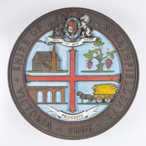
Sign - Shire of Strathfieldsaye Coat of Arms
The district of Strathfieldsaye was proclaimed in 1861 and named a Shire on the 17th September in 1866. It remained a shire until amalgamation in 1994 when it became part of the City of Greater Bendigo. The shire was located 8 km to the south- east of Bendigo and covered an area of 601 square kilometres and extended from the Calder Highway to the Coliban and Campaspe Rivers. The shire's administration centre was in Strathfieldsaye until 1972 when new offices were opened in Kennington. This coat of arms was commissioned for the front of the shire hall building.Brass painted coat of arms or emblem within a circle of the Shire of Strathfieldsaye. Outer rim contains text: SHIRE OF STRATHFIELDSAYE VICTORIA 1866 with the shield of the monarch of the United Kingdom centre top. The shield is divided into four parts with images reflecting the leading industries of the time; wine growing, mining, farming and tanning. The motto PROGRESS is depicted lower centre of shield. SHIRE OF STRATHFIELDSAYE / VICTORIA / 1866 / PROGRESSshire of strathfieldsaye, city of greater bendigo amalgamation, city of greater bendigo signs -
 City of Greater Bendigo - Civic Collection
Letter - Correspondence between National Gallery of Victoria and Bendigo Art Gallery, Gorden Thomson, Deputy Director, National Gallery of Victoria, 16th February, 1961
Bendigo Art Gallery was founded in 1887. Typed and signed letter from Gordon Thomson, Deputy Director of the NGV addressed to Mr W. B. Bolton at Bendigo Art Gallery. Letter is on National Gallery of Victoria letterhead requesting photographs and information about the gallery on behalf of UNESCO for publication in the International journal 'Museum'. The letter has a postcard of the gallery taped to top left. Possibly related to Cat No 0305.Postcard lower centre; Murray Views No 35. Art Gallery, Bendigo Victoriabendigo art gallery, city of greater bendigo tourism -
 City of Greater Bendigo - Civic Collection
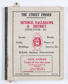
Book - Street Directory, McConnell Publisher, The Street Finder
General district street, business and services directory aimed less at the tourist market and more at the Bendigo and Eaglehawk population. Includes advertising. Index is extensive and includes services such as child care centres, cemeteries, theatres and schools.Thirty two page, printed and bound street and business directory for Bendigo, Eaglehawk and district. Grey card front cover with grey cardboard back cover. Printed in red and black ink. Includes Index for trades, streets and services such as banks, baths, sporting clubs and police stations. Majority of content is text and advertising and the only map included in the publication is printed inside the back cover.The Street Finder / for the municipalities of / Bendigo, Eaglehawk / & District. city of greater bendigo commerce, city of greater bendigo community groups, city of greater bendigo tourism, borough of eaglehawk, making a nation exhibition -
 City of Greater Bendigo - Civic Collection
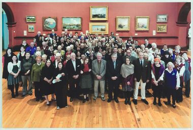
Photograph - Group Portrait, City of Greater Bendigo, 2011
This group portrait was taken at a City of Greater Bendigo function marking the 100,000th visitor entering the Grace Kelly: Style Icon exhibition.Colour photograph taken at the Bendigo Art Gallery of gallery staff and volunteers, Visitor Centre staff and volunteers, Mayor Sandner, CEO Craig Niemann and various other COGB staff.city of greater bendigo tourism, bendigo art gallery, mayor sandner