Showing 2050 items matching " building plans"
-
 University of Melbourne, Burnley Campus Archives
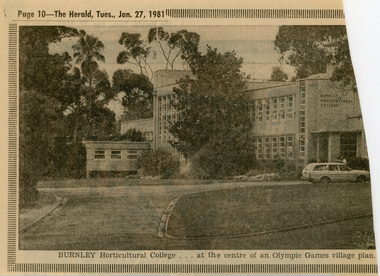
Newspaper - Newspaper Cutting, The Herald, Our Games bid Blossoms, 1981
Cutting of an article by Alan Tate, from The Herald, January 27, 1981. It was mooted that the Olympic Village for the 1988 Olympic Games (which may have been held in Melbourne) was proposed for the grounds around VCAH Burnley. The principal, Mr Davis, is stated to have been keen about the prospect because of the huge influx of money there would have been for the college. There are 2 photos, one of the main college building with the caption: "Burnley Horticultural College... at the centre of an Olympic Games village plan" and the second with the caption: "Burnley Horticultural College principal Mr Jim Davis shows where the Games village could be built." alan tate, the herald sun, olympic games, 1988, vcah, burnley gardens, olympic village, jim davis, principal -
 St Kilda Historical Society
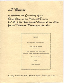
Ephemera - Menu, A Dinner to Celebrate the Launching of the Final Stage of the National Theatre, 1973
Contains information about the formation and growth of the National Theatre Movement and statistics about the construction of the new National Theatre in the building formerly known as the Victory Theatre, on the corner of Carlisle and Barkly Streets, St Kilda. A dinner to launch the final stage of construction was held on 4 December 1973. Completion was planned for 15 June 1974 and the official opening date was to be 24 August 1974. The dinner was hel at the Stardust, Marine Parade, St Kilda and was hosted by the Victorian Ministry for the Arts.Yellow coloured card printed in black on one side and brown on the othernational theatre, stardust -
 Federation University Historical Collection
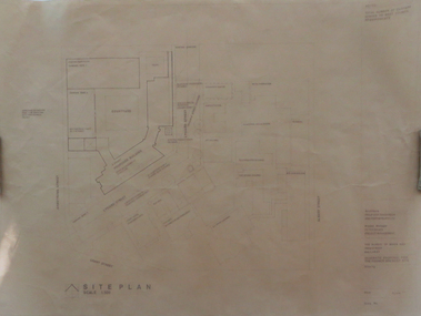
Plan, Ballarat School of Mines Schematic Proposal for the Former Ballarat Brewery Site
... Brewery Building was Peter Davies. The plan suggests the closure ...The Project Manager for the Ballarat School of Mines Brewery Building was Peter Davies. The plan suggests the closure of Lydiard Street South Copy of the Site plan for the Ballarat School of Mines Brewery Building, built on the site of the former Ballarat Brewery. The plan shows where the new building sites in relation to all other buildings at the Ballarat School of Mines ballarat school of mines, brewery building, ballarat brewery, architectural plans, schematic proposal, smb campus, former ballarat gaol, chimney tower, m.b. john building, lydiard street south, armstrong street south -
 Federation University Historical Collection
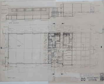
Plan, R.L.F.J. Hillman Recreation Building
... , Grant St R.L.F.J. Hillman Recreation Building Plan Plan ...Photocopy plansn for proposed recreation building, Grant St mr hillman, g. hewitt, hillman recreation building, school of mines ballarat -
 Buninyong Visitor Information Centre
Document (Item) - Information Folder, Buninyong Mechanics Institute and Free Library
Copies of images showing the development of and changes to the library building.buninyong mechanics institute, buninyong library, buninyong -
 Mission to Seafarers Victoria
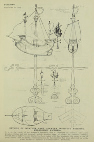
Drawing - Digital copy, Building Publishing, Details of weather vane, Seamens' Institute building, Melbourne, Victoria, 12 September 1923
This sketch was published in Building : the magazine for the architect, builder, property owner and merchant, Vol. 33, No. 193 (12 Sept., 1923) but Walter Butler had imagined it in the design for the mission in 1916/17. In the article published in the Herald, Thursday 30 August 1917, page 12, it is mentioned the "the architect has designed a copper ship final for the main gable of the building and it, like the gymnasium, is awaiting the collection of more funds or the generosity of a special donor."The plans confirm that Walter Butler was the designer of the vane that he had already imagined in the early sketch of the Flinders Street building in 1916 and also help us determine when was the vane made.This article was published in 1923 and the first photograph of the weathervane was only published in the 1928 Annual Report. The plans are significant as they could potentially help rebuild the weathervane stole in March 2022. Plans for the weather vane, Seamens' Institute building, Melbourne, Victoriawalter richmond butler (1864–1949), windvane, weathervane, finial, flinders street -
 Eltham District Historical Society Inc
Document - Report, Paul Jerome, Advisory Committee on a Proposed Convenience Centre and an Alternative Shire Proposal - Eltham Gateway Community Precinct Concept Plan - 895 Main Road Eltham, October 1997
On 15 December 1994 the former Shire of Eltham ceased to exist following the Liberal Kennett Government local council amalgamations. A new Nillumbik Shire Council was established with unelected commissioners appointed. That Council sold the former Eltham Shire Council Offices and land at 89S Main Road Eltham to Dallas Price Homes Pty. Ltd. the sale being conditional upon the granting of a planning permit for a petrol station/convenience store, fast food and video outlet. The sale was conditional that if the permit was not granted by 30 August. 1997, the contract could be avoided by either the purchaser or the vendor. The proposed development consisted of a petrol station with undercover fuelling facilities, convenience shopping, a drive through service facility for fast food, an 80 seat cafe, automated banking, a children's play area and retail space. In addition, the proposal included a 200 square metre community facility for Council use, provision of on site carparking over 2 levels for 83 vehicles, and advertising signage. An Advisory Committee consisting of Dimitry Reed and Margaret Pitt was appointed under Section 151 of the Planning and Environment Act 1987 to hear submissions on the proposal to develop the land at 895 Main Road Eltham, the site of the former Eltham Shire Offices. In September 1996, two applications were made by Contour Consultants Australia Pty Ltd on behalf of Dallas Price Homes Ply Ltd, to Nillumbik Shire Council. After extensive notification, the Council received 213 objections and a petition of over 1400 signatures. On October 9, 1996, Nillumbik Shire Council issued Notices of Decision to Grant Permit on Applications number 96/03376 and 96/0377 for the use and development of the land as a convenience Centre consisting of a petrol station, convenience store, cafe/takeaway food premises, a retail facility and a community facility, with associated advertising signs. Objectors to the proposals lodged Planning Appeals number 96/40724 and 96/40812 with the Administrative Appeals Tribunal on November 1, 1996. The grounds of appeal can be summarised as: inappropriate development, insufficient carparking, traffic and access issues, unsatisfactory design, inadequate permit conditions, the proposal being out of character with the area. and being contrary to the purpose and orderly development of the Eltham Town Centre, excessive noise, lack of consultation and unsuitable signage. On November 13, 1996, the Minister for Planning and Local Government directed the Registrar of the Administrative Appeals Tribunal. under Section 41 (1) (a) of the Planning Act 1980, to refer the Appeals to the Governor in Council for determination without a hearing or recommendation by the Tribunal. The Minister for Planning and Local Government called in the Appeals as he considered that they raised major issues of policy relating to the facilitation of development in accordance with the objectives set out in Section 4 of the Planning and Environment Act 1987, and that determination of the Appeals could have a substantial effect on the achievement of these planning objectives. The Minister required the Advisory Committee to consider the planning merits of the proposed use and development, and to address the issues raised in the objections. The Advisory Committee was required to produce a report providing: • The Committee's response to the matters detailed; • Relevant supporting information for the Advisory Committee's recommendation; and • A description of the proceedings conducted by the Advisory Committee and a list of those consulted or heard by the Committee. In March 1997, elections were held in the Shire of Nillumbik and the view of the new Council to this proposal differed from the view held by the earlier Council Hence the Submission made to the Committee by the Shire was against the decision by the Shire of Nillumbik to issue the Notices of Decision to Grant a Permit. The Recommendations of the Advisory Committee were: i. The cafe and take away food premises are as of right uses and are therefore allowable, but that shop and petrol station are unacceptable uses. A community facility is a discretionary use and is acceptable. ii. A development of the type and scale proposed is totally inappropriate for this land and that the Applications number 96/03376 and 96/0377 for the use and development of the land as a convenience Centre consisting of a petrol station, convenience store, café/takeaway food premises, a retail facility and a community facility, with associated advertising signs, be refused. iii. The land should be rezoned for public purposes and should remain in the community's ownership for community use. Following this, the Minister for Planning and Local Government, the Hon. Robert Maclellan, appointed Mr. Paul Jerome as an Advisory Committee under section 151 of the Planning and Environment Act 1987 to consider a Convenience Centre and an alternative proposal by Iha Shire of Nillumbik being the Eltham Gateway Community Precinct Concept Plan for the site of the former Shire of Eltham municipal offices at 895 Main Road, Eltham. In summary, the terms of reference for the Advisory Committee required it to: • consider the merits of the Council proposal • examine the merits of both proposals in terms of net community benefit • address the report of the previous Advisory Committee on the Convenience Centre proposal The Advisory Committee inspected the site and considered all the material before It including submissions made by all parties to the previous Advisory Committee and correspondence received by the Department of Infrastructure both before and after that Committee submltted its report. The Advisory Committee also held discussions with the following people: • Cr. Robert Marshall • Cr. Margaret Jennings • Cr. Lex de Man • Mr. Dallas Howgate of Dallas Price Properties, also Dallas Price Homes • Mr. Barry Rochford, CEO, Shire of Nillumbik • Ms. Yvonne Rust, Planning Officer, Shire of Nillumbik • Mr. Gregory Burgess, Architect of the Eltham Library and of Council’s Community Precinct Concept Plan • Mr. Jim Connor representing Mrs Thelma Barkway of the Eltham Senior Citizens Club Having considered all the material before it, the Committee arrived at two basic conclusions. First, the DPP proposal should be rejected because, on its merits, It does not sufficiently satisfy the requirements of the planning scheme which is a statutory document. The planning scheme requires that, before making a decision on the permit applications for the DPP proposal, a range of matters must be considered. It follows that consideration of these matters should Influence the decision. These matters include local policies relating to character and amenity. In particular, these policies seek • to conserve and enhance the bushland/country atmosphere, artistic heritage and strong sense of community of the Eltham Town Centre by ensuring that the design and height of any new development is sympathetic to existing buildings • to achieve a pleasing physical environment within the Eltham Town Centre by encouraging a high standard of architecture and urban design • to encourage Improvement to pedestrian amenity through such facilities as open and shattered rest areas and meeting places, crossing facilities, pedestrian arcades, pedestrian links to car parks and pedestrian weather protection • to reduce conflict between vehicular traffic and pedestrian flows, and • to encourage pedestrian thoroughfares It is submitted, as set out In the main body of this report, that the DPP proposal fails substantially to meet these policies and In so doing does not merit the exercise of discretion In Its favour with the Issuing of a permit. This finding is not offset by the investment and employment attributes of the proposal. They do not override the need to comply with the planning scheme. Second, the Council proposal, on Its own merits, substantially meets all statutory requirements applicable to this site with a possible reservation about car parking and traffic management which need further definition and assessment as the concept is refined. The Council proposal, however, has a serious weakness in that Its financial viability has not been adequately tested. The Committee refers to 'financial' rather than 'commercial' viability in recognition that Council owns the land and may enter into a range of agreements and partnerships to realise its concept some of which may be truly commercial and some of which may involve an element of subsidy arising from Council's involvement as a public body acting on behalf of its community. The Committee concludes that Council should be given the opportunity, within a reasonable timeframe to establish the financial feasibility of its concept and should develop a strategy for the future of Its land asset at 895 Main Road in the event that Its concept for the site cannot be realised. 895 main road, advisory committee, dallas price homes, eltham, eltham shire office, nillumbik shire council, planning application, administrative appeals tribunal -
 Eltham District Historical Society Inc
Film - Video (VHS), Jenni Mitchell, Demolition of the Shire of Eltham Offices, 1996
Poor video quality (noise and interference), incomplete and unedited raw footage. A video documenting the demolition of the Shire of Eltham offices at 895 Main Road Eltham under the direction of the Commissioners appointed for the new Shire of Nillumbik and some of the communities activities surrounding the event. The building was demolished exactly 25 years after the southern wing housing Engineering and Planning on the upper level and the Eltham Library on the ground level was opened in celebration of the Shire of Eltham's centenary. Video has lots of distortion and noise, and sections of clips dubbed over. Immediate initial footage of Jenni Mitchell talking about asbestos claims in the Shire Offices (Sigmund Jorgensen standing behind her) advising Council did a review of the building several years previously and had been cleared of health problems. Cuts to group of people standing outside front door of offices but possibly voice dub over not related ? Then the date 27 Jul 1996 on a scene flashes on screen immediately followed by an edited clip intro of title and credits with classical music track. It then opens with Jenni Mitchell driving to the Shire Offices on Saturday 27 July 1996 at 11.00am. Footage of Main Road past Pitt Street, Alistair Knox Park then entering Shire Office driveway which is fenced off and contractor signs hanging up. Scenes at rear of building showing some internal demolition has commenced. View of the Administration wing. More clips of road driving, Alistair Knox Park, Eltham Library and visitor car park for Shire Offices. Cuts to a group of people standing in access to visitor carpark with new Eltham Library in background, one being immediate former Shire of Eltham President, John Graves. Scenes of people looking through chain link fence and security guard checking front door. John Graves being filmed that someone informed him the Shire was offering the building to the Community Health Centre for $2.3 million and that if they had been offered a price of $1.1 for what it apparently was sold for they would have snapped it up. View of truck loaded with brick rubble literally struggling to ascend the hill of Library Place to exit into Main Road. Cuts to a scene looking at Eltham War memorial Hall through the Memorial Gate, then the Shillinglaw trees and large banner sign ‘Delta Demolitions’ hanging on office façade. Views of front door, old library and bluestone wall. Scene (31 Jul 1996) filmed at night of several white crosses with “RIP Community” and “RIP Democracy”. Scene (1 August 1996) again driving along Main Road towards the Shire Offices then scenes of the offices showing substantially more demolition to exterior, groups of people standing on footpath outside watching, Delta heavy demolition machines, woman holding sign “Democracy where have you gone …”, the odd person in full protection gear and breathing apparatus hand carrying materials out to place on rubbish pile in front of people standing on footpath watching (with no protection) and then stamping on it to break it creating dust, security person in hard hat (no other protection) wandering around, many groups standing around watching, news film crew, person standing on roadside edge holding signs facing traffic stating “Pirate Planning” and “ Grant us your ears” also sign on back of parked car “Elthams High Jacks”, another sign “Community Democracy”, views of crosses in Main Road median strip “RIP Community”, groups of people on footpaths and reporters conducting interviews, footage of unknown person standing with Jenni Mitchell and Sigmund Jorgensen advising people have the right to protest, Jenni Mitchell urging people to ask questions of local MP and Council and Sigmund Jorgensen referring to the three historic Shillinglaw trees with demolition machinery operating in background, Jenni Mitchell and others installing more crosses in median strip; demolition machines operating inside and outside the building, more views of onlookers including Sigmund Jorgensen then Police approaching on footpath, workers and machinery continuing to operate, views of the old library being demolished, the former Community Services department, security personnel. Scene (2 August 1996) more heavy demolition machinery in operation smashing building up, people standing around southern wing watching, view overlooking Eltham Library of train pulling in to Eltham station. Scene (7 August 1996) more heavy demolition and people wandering around with only hard hat protection, no dust protection, comments from one operator dumping a bin of material stating “wait till there’s a Hungry Jack’s here, you’ll be laughing, fuel, videos, hamburgers. You’ll be up with the rest of the world soon, you’ll have electricity and everything here, ha ha ha ha”, more heavy machinery demolition and breaking up of materials, view of Hitachi train going by and Administration wing, view inside the front door opening of the staircase leading to upper level, person walking around operating heavy machinery with a hose spraying rubble (no protective gear other than hard hat interspersed with edit cuts of meeting of Commissioners and independent observers on panel as well as members of the community in public gallery. Nillumbik Shire CEO Barry Rochford addressing the meeting., Chief Commissioner Don Cordell directly addressing Jenni Mitchell with respect to permission to take photographs, Barry Rochford continues to address the question asked of Council about the valuation of the former Shire of Eltham Office building/site, public gallery calling out asking why was building demolished, what was the urgency. Scene (14 August 1996) views of southern wing, previous single demolition operator again mocking people filming, operators working in and around building, Shillinglaw trees and largely demolished front, heavy demolition equipment at work, piles of building rubble, hose spraying water over rubble, large trucks arriving for rubble removal and loading of truck. Scene (21 August) more of the same, building virtually down, Shillinglaw trees standing tall and alone, water spraying on rubble and wattle in bloom. Cuts to Council meeting with public onlookers. Barry Rochford walks out, Wayne Phillips addresses meeting explaining one or two people shouting, members of the community challenging Council (Commissioners) about why due process appear to have been subverted. Former Shire President Robert Marshall in public audience, cuts back to Shire office carpark entrance site and sign hung on fence in front of library “Think Again!” and people standing around observing awaiting a protest demonstration erecting a large sign on stilts stating “Shell No!”, people singing a revised version of God Save the Queen (God Save Us All), Sigmund Jorgensen in attendance, Jenni Mitchell, Sigmund Jorgenson and others address the protest crowd, followed by people mingling, music being played then people standing around the cleared site circumference all with arms linked (video very broken up with noise) then chants “Save the Gateway” and “No Shell for Eltham” and more music and singing “Put up a parking lot”. The crowd then proceeds to walk along the footpath of Main Road. Scene (15 Sep 1996) meeting at Montsalvat in Great Hall addressed by Sigmund Jorgensen discussing a recently published list of the Commissioner’s to senior Council Officers of banned Nillumbik people, others encouraging people to view proposed plans for the site and lodge objections. Specific issues regarding asbestos claims are also addressed. Harry Gilham addresses the meeting on the subject of the Eltham War Memorial and Memorial Gardens and how Council believe a roundabout in the vicinity is of greater importance. Views of various artworks on display (for auction) and music performance in the Barn Gallery. Meeting addressed by Sigmund Jorgensen discussing an appeal against Council granting a permit to Dallas Howgate to develop the site and that the Minister has called the matter in to be decided by the governing council. This is followed by an auction of paintings. 0.05 - Jenni Mitchel, Sigmund Jorgensen and Peter Doughtery in background. 0.18 - Jock Kyme in front of building – David Essex, Marg Johnson on his left-hand side. 5.34 - John Graves – ex Shire of Eltham Councillor and President. 9.02 - Unknown person being interviewed. 9.30 - Jenni Mitchell, unknown person, Mark Burns, community activist. 10.04 - Sigmund Jorgenson, Jenni Mitchell. 12.04 - Police members 21.33 - Nillumbik Council offices 7 August 1996 Barry Rochford CEO, Vin Heffernan Commissioner, Don Cordell Chief Commissioner, Kevin Abbott Commissioner, unknown person. 28.00 - Barry Rochford CEO 28.05 - Kahn Frankie - in commissioner’s seat after commissioners and council staff have vacated the council chamber. 28.26 - Wayne Phillips, State Liberal member for Eltham, addressing community in response to questions. 28.36 - Mark Burns, community activist addressing gallery. 28.48 - Ken Hines, ex Shire of Eltham Councillor and President. 29.34 - Ken Hines, ex Shire of Eltham Councillor and President standing, Robert Marshall, ex Shire of Eltham Councillor and President seated in front. 29.41 - Karen Gerhards, community activist. 30.06 - Marg Johnson with loud hailer, next to Jock Kyme, community activist. 31.32 - Marg Johnson with possibly Frank Burgoyne?, Sigmund Jorgensen, Jock Kyme. 35.35 - Harry Gilham at meeting at Montsalvat on 15 September 1996. 35.43 - Sigmund Jorgenson at lectern. 36.42 - Marg Jennings. 37.47 - Mark McDonald, Jim Connor, ex Shire of Eltham Councillor in background. 36.28 - John Cohen, ex Shire of Eltham Councillor and President. 38.56 - Ken Hines, ex Shire of Eltham Councillor and President. 41.11 - Harry Gilham, president of the Eltham District Historical Society. 43.55 - Sigmund Jorgensen in Long Gallery at Montsalvat, at start of the art auction to raise funds for community action. 45.50 - Unknown person conducting art auction. VHS Video cassette (poor quality) Converted to MP4 file format 45:01, 535MBvideo recording, 895 main road, alistair knox park, artworks, auction, barn gallery, barry rochford, community health centre, dallas howgate, delta demolitions, demolition, don cordell, eltham, eltham library, eltham shire office, eltham war memorial, eltham war memorial gate, eltham war memorial hall, great hall, harry gilham, jenni mitchell, john graves, library place, main road, memorial gardens, mervyn hannan, montsalvat, pitt street, protest, robert marshall, roundabout, shell oil, shillinglaw trees, sigmund jorgensen, sign, wayne phillips -
 Ringwood and District Historical Society
Document - Folder, Land Sale - Monterey Park Subdivision, Warrandyte Road, Ringwood North, Vic. - 1981
Foolscap manilla folder containing double-sided flyer advertising residential subdivision development, including outline of local facilities and services, with locality map and layout of Monterey Park streets. Subdivision includes Parkwood High School, Tortice Drive, Heape Way, Appleberry Place, Stringybark Court, Conifer Court, Crawley Grove, Monterey Close (later Monterey Place), Lucy Place, Middlebrook Drive, Gahnia Close, Glanfield Court, Cone Close, Jull Parade, Pinus Close (later Pinetree Court), Radiata Close, Old Warrandyte Road, and entry from Warrandyte Road. Vendor - Jennings Industries Limited, 690 Springvale Road, Mulgrave, 3170, Phone 5618000. A4 enclosures with tables showing each allotment List Price, Builders Price, Cash Price and Terms Price. Information page headed "Form of Restrictive Covenant to be incorporated in Transfer" specific to Certificates of Title. Restrictive Covenant (summary): (Name/s) "... will not erect or construct or cause to be erected or constructed on the land hereby transferred (a) Any front boundary fence, other than a fence which does not exceed one metre in height unless the same is set back as least 1.5 metres from the front boundary and the same is effectively screened from that boundary by the planting of trees, shrubs or plants. (b) Any side boundary fence other than a fence which is set back at least 1.5 metres from the front boundary on which does not exceed 1 metre in height within 1.5 metres of the front boundary. (c) For a period of 5 years from the date hereof, any building on the said land unless and until the Plans and Specifications thereof have first been approved by the said Residential Developments Pty. Limited. (d) For a period of 2 years from the date hereof whilst the said land remains vacant any Signboard or Notice advertising the sale of the said lot or any other lot. These covenants shall appear on the Certificate of Title to issue for the said land and run with the land." -
 Linton and District Historical Society Inc
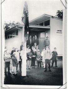
Photograph, Opening Day, New Linton School Building, 1969
Although plans had been drawn up in 1966 to renovate the earlier brick school building, this building was afterwards declared unsafe, and a new "modular" building was erected in 1969.Copy of original black and white photograph which shows a group of pupils, teachers, dignitaries and others outside the new Linton State School building, on its official opening day 8th September 1969.linton state school no. 880, opening day 1969, new building -
 Lakes Entrance Historical Society
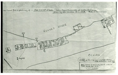
Photograph - New Works Plan, 1898
Map traced from a photocopy of :- Map TP8A Bairnsdale. 'Site. Sand Hummocks of Lakes Entrance'. Drawn by John Lardner 18 January 1898. Scale two chains to one inch. ( A photocopy of this map in Latrobe Library map collection, June 1983)Black and white photograph showing sketch map of 1898 by John Lardner Plan of Sites - sand hummocks. Drawing shows sites of buildings at entrance along Cunninghame Arm shoreline at Lakes Entrance, Victoria.land settlement, plan -
 Bendigo Historical Society Inc.
Document - Gemma Starr collection - Bendigo East Primary School - folder contains documentation of the support and submission to Council to Save the Bendigo East Primary School Avenue of Honour
Gemma Starr collection - Bendigo East Primary School - folder contains documentation of the support and submission to Council to Save the Bendigo East Primary School Avenue of Honour. Folder covers: Zoning, Policy, Maps, Heritage, Amenity and Trees documentation. Submissions had concerns about the subdivision, and the removal of trees on the site, impacting the school building.social, local history, bendigo east primary school, planning permit and objections -
 Linton and District Historical Society Inc
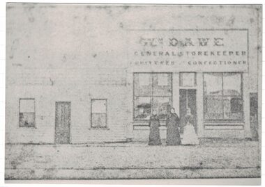
Photograph, Dawe's Store
The Dawe family shop is thought to have been in Sussex Street/Skipton Road, opposite Wishart's forge. W. Dawe is shown on the Township of Linton plan as the owner of Allotment 4, Section 1A. Municipal directories show "William Dawe, Fruiterer" in the 1880s, and from the 1890s "Thomas Dawe, Fruiterer". (Thomas was William Dawe's son.)A black and white copy of an original faded Photostat which shows three women standing in front of a building "Wm. Dawe General Storekeeper Fruiterer Confectioner".william dawe, shops, general store, sussex street, robert s. nelson (jnr) -
 Glen Eira Historical Society
Photograph - Elsternwick Club, Sandham Street, 19, Elsternwick
Four items about the Elsternwick Club: 1/ An undated black and white photograph (90mm x 140mm) of the exterior of the Elsternwick Club Building at Sandham Street. 2/ Two identical postcards advertising the opening of the Tabaret at the Elsternwick Club in 1996, with four historic photographs of the club included on the front. The back advertises the opening hours, price of alcohol and gaming machines. 3/ An original colour site plan (300mm x 290mm) on tracing paper in ink of the Club’s premises, prepared by Thomas Watts and Son Architects 77 Swanston Street with a colour photocopy of this same plan. 4/ Photocopy of page 15 from the 1985 second edition of the City of Caulfield's "caulfield's building heritage" directory and information guide which provides basic information about the Elsternwick Club building and includes an illustration (115mm x 85mm) of the exterior of the Club.For item 1 inscription: Elsternwick Club Sandham Stst georges road, elsternwick, elsternwick club, thomas watts and son, sandham street, site plans -
 Whitehorse Historical Society Inc.
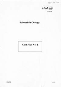
Document - Project Plan, City of Whitehorse, Schwerkolt Cottage - Cost Plan No.1, 23/02/2006
A cost analysis for the extension, alteration and repairs to the Schwerkolt Museum building and construction of a new building for the agricultural exhibits.A cost analysis for the extension, alteration and repairs to the Schwerkolt Museum building and construction of a new building for the agricultural exhibits.A cost analysis for the extension, alteration and repairs to the Schwerkolt Museum building and construction of a new building for the agricultural exhibits.city of whitehorse, schwerkolt cottage and museum complex, museum development, agricultural machinery -
 Wodonga & District Historical Society Inc
Photograph - Hut 97 Bonegilla Migrant Experience
Bonegilla Army Base and Migrant Reception Centre began when funds were allocated to build Bonegilla Army Camp in June 1940. Builders began to erect about 600 huts prior to the Army moving in during September of that year. Between 1942 - 1943 it was enlarged to 848 buildings. In 1947 Bonegilla Reception and Training Centre began operating with the Army providing transport, security and catering services. From 1949 until 1965 the Bonegilla Reception and Training Centre operated without a military presence. Bonegilla Migrant Reception and Training Centre was made up of 24 blocks. It had its own churches, banks, sporting fields, cinema, hospital, police station and railway platform. It became the largest and longest operating reception centre in the post-war era. More than 300,000 migrants passed through its doors between 1947 and 1971, with most of those originating from non-English speaking European countries. From1965 with the increased Australian commitment to the Vietnam War and the need to find accommodation to train National Servicemen for Vietnam, the Army negotiated with the Department of Immigration to take over several blocks at Bonegilla. In 1971 the Reception Centre closed and the site reverted to the Army. After 1971 the Army undertook a major site redevelopment with the construction of Latchford Barracks as the Army Apprentice School. Later Latchford Barracks was redeveloped into part of the Army Logistic Training Centre. Between 1978 and 1982, nearly all of the centre was demolished in a major redevelopment. The new replacement buildings were formally opened as Latchford Barracks in 1983. Demolition of the buildings prompted calls for recognition of the site and the role it had played in Australia’s post-World War II Immigration program. After much discussion between the Department of Army and Heritage and local groups about the significance of the site, the Australian Heritage Commission proceeded with its listing on the Register of the National Estate. A Conservation Management Plan was prepared for Block 19 in 1996. The Army transferred Block 19 to the Victorian Government. In 2002 Heritage Victoria listed Block 19 on the State Heritage Register, giving attention to both the migrant and army connections with the site. Hut 97 at Bonegilla Migrant Experience is the home of the Wodonga & District Historical Society Inc.This image is significant because it records a building which is part of the Bonegilla Migrant Reception Centre which played a critical role as the largest and longest operating Migrant Reception Centre in Australia.A colour photo of Hut 97 at Block 19, Bonegilla Migrant Experience, now the home of Wodonga & District Historical Society Inc.hut 97 bonegilla migrant experience, wodonga & district historical society, immigration australia -
 Glen Eira Historical Society
Document - Historic Conservation Areas Project
... Conservation Areas Project Niven Barbara Newsletters Town Planning ...Contains 4 items relating to historic conservation: 1/Five newsletters (one page each newsletter, dated 07/1975, 08/1975, 09/1975, 10/1975 and the final one 12/1975) describing how the project evolved, project funds, progress, study method, project 1 report, project 2 report and summary as no further funds available. Project was to include all of Melbourne but funding did not allow this. Note: newsletters stamped with Caulfield Historical Society. 2/Letter (one page on official city of Caulfield letterhead) from Andrew Rodda (manager planning) to Hazal Ford (dated 13/11/1989) describing ‘council resolved on 18/07/1989 to proceed with preliminary conservation survey’ and mentions that a copy is included. 3/Preliminary conservation survey for the City of Caulfield (nine pages) describing background, study area, budget, purpose, study outline, timeframe, report format, ownership, tasks and background information (mentions number and types of houses and properties as at 1986 and 1988) and a map of City of Caulfield. 4/Booklet (28 pages) titled ‘Heritage Area – Caulfield North Draft Heritage Guidelines July 1999 – City of Glen Eira’, containing Caulfield North Heritage Area, cultural heritage, Heritage Overlay Area, architectural description, common architectural forms and features, development guidelines, key design checklist. It includes a map of the Caulfield North Heritage Overlay Area, two illustrations about the development envelope and many black-and-white photographs of houses and architectural features.historic conservation areas project niven barbara, newsletters, town planning, historic buildings, heritage studies, housing, royal historical society of victoria (rhsv), read michael, plans, local government, historical societies, committee for urban action (cua), national trust, hopkins sherry ms., ford hazel, preliminary conservation survey, town planning, heritage studies, rodda andrew, city of caulfield, housing estates, victoria national estate grants program, australia icomos, burra charter, buildings structures and establishments, land surveys, suburbs, historic buildings, architectural significance, ‘caulfield’s heritage study’, soloman geulah dr., caulfield library, dandenong road, nepean highway, hotham street, iknerman road, orrong road, north road, poath road, ‘plan of the city of caulfield’, north ward, east ward, south ward, west ward, kooyong road, neerim road, bambra road, balaclava road, shire of caulfield, railways, world war 1914-1918, depression 1929-1939, rippon lea, labassa, parks, mansions, community services, ‘caulfield north draft heritage guidelines july 1999’, city of glen eira, caulfield north heritage area, glen eira heritage management plan, mayfield grove, normanby avenue, carnarvon street, glenferrie street, arthur street, malakoff street, normanby road, heritage advisory service, construction materials, victorian style, mediterranean style, spanish mission style, californian bungalow style, federation style, architectural style, architectural features, heritage conservation design, building construction, building regulations, aboriginal peoples, carnarvon road -
 Falls Creek Historical Society
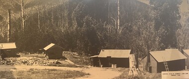
Photograph - Bogong Alpine Village Houses 1946
The images in the Bogong Village Collection were displayed in Bogong Jack’s Tavern for over 20 years and were donated to the Falls Creek Museum when the Tavern closed in 2021. In 1939, the State Electricity Commission of Victoria established a field headquarters at Bogong to house workers and their families for the Kiewa Hydroelectric Scheme which ran from the 1930s to the 1960s. The workmen's camp was originally started with tents and was called Junction Camp. By 1947, the village supported 300 workers and their families. It included 40 houses, a hostel for single staff, a post office, a police station, a medical centre, and a primary school. The staff hostel was known as Kiewa House. At the completion of the Scheme, in the 1960s, the village was opened to public/tourism use. In 1968 the Victorian Education Department acquired the camp buildings and four houses from the State Electricity Commission of Victoria to establish an Outdoor Education Centre which operated for over 50 years. The Kiewa Hydroelectric Scheme was privatized in the 1990s and sold to Southern Hydro, before being acquired by AGL in 2005. In 2023 the Grollo Group signed a 73 year sublease on Bogong Village and has plans for its redevelopment as a workers’ village.These images are significant because they capture the development of Bogong Village as an important element of the Kiewa Hydroelectric Scheme in Victoria.Two black and white images featuring houses in Bogong Village in January 1946. They are constructed of weatherboard, with brick chimneys and tin roofs. Timber steps lead up to the front door and a garden has been planted in front of the house.bogong alpine village, bogong high plains, bogong houses 1946 -
 Falls Creek Historical Society
Photograph - Bogong Alpine Village 1944
The images in the Bogong Village Collection were displayed in Bogong Jack’s Tavern for over 20 years and were donated to the Falls Creek Museum when the Tavern closed in 2021. In 1939, the State Electricity Commission of Victoria established a field headquarters at Bogong to house workers and their families for the Kiewa Hydroelectric Scheme which ran from the 1930s to the 1960s. The workmen's camp was originally started with tents and was called Junction Camp. By 1947, the village supported 300 workers and their families. It included 40 houses, a hostel for single staff, a post office, a police station, a medical centre, and a primary school. The staff hostel was known as Kiewa House. At the completion of the Scheme, in the 1960s, the village was opened to public/tourism use. In 1968 the Victorian Education Department acquired the camp buildings and four houses from the State Electricity Commission of Victoria to establish an Outdoor Education Centre which operated for over 50 years. The Kiewa Hydroelectric Scheme was privatized in the 1990s and sold to Southern Hydro, before being acquired by AGL in 2005. In 2023 the Grollo Group signed a 73 year sublease on Bogong Village and has plans for its redevelopment as a workers’ village.These images are significant because they capture the development of Bogong Village as an important element of the Kiewa Hydroelectric Scheme in Victoria.A collection of four black and white images capturing the weather conditions in the Bogong area in June 1944bogong alpine village, bogong high plains, bogong june 1944 -
 Falls Creek Historical Society
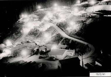
Photograph - Bogong Alpine Village 1947
The images in the Bogong Village Collection were displayed in Bogong Jack’s Tavern for over 20 years and were donated to the Falls Creek Museum when the Tavern closed in 2021. In 1939, the State Electricity Commission of Victoria established a field headquarters at Bogong to house workers and their families for the Kiewa Hydroelectric Scheme which ran from the 1930s to the 1960s. The workmen's camp was originally started with tents and was called Junction Camp. By 1947, the village supported 300 workers and their families. It included 40 houses, a hostel for single staff, a post office, a police station, a medical centre, and a primary school. The staff hostel was known as Kiewa House. At the completion of the Scheme, in the 1960s, the village was opened to public/tourism use. In 1968 the Victorian Education Department acquired the camp buildings and four houses from the State Electricity Commission of Victoria to establish an Outdoor Education Centre which operated for over 50 years. The Kiewa Hydroelectric Scheme was privatized in the 1990s and sold to Southern Hydro, before being acquired by AGL in 2005. In 2023 the Grollo Group signed a 73 year sublease on Bogong Village and has plans for its redevelopment as a workers’ village.These images are significant because they capture the development of Bogong Village as an important element of the Kiewa Hydroelectric Scheme in Victoria.Two black and white images capturing Bogong Village by night and the spillway at Junction Dam.bogong alpine village, bogong high plains, bogong 1947 -
 Falls Creek Historical Society
Photograph - Jack Maddison Leading horses on the Bogong High Plain
The images in the Bogong Village Collection were displayed in Bogong Jack’s Tavern for over 20 years and were donated to the Falls Creek Museum when the Tavern closed in 2021. In 1939, the State Electricity Commission of Victoria established a field headquarters at Bogong to house workers and their families for the Kiewa Hydroelectric Scheme which ran from the 1930s to the 1960s. The workmen's camp was originally started with tents and was called Junction Camp. By 1947, the village supported 300 workers and their families. It included 40 houses, a hostel for single staff, a post office, a police station, a medical centre, and a primary school. The staff hostel was known as Kiewa House. At the completion of the Scheme, in the 1960s, the village was opened to public/tourism use. In 1968 the Victorian Education Department acquired the camp buildings and four houses from the State Electricity Commission of Victoria to establish an Outdoor Education Centre which operated for over 50 years. The Kiewa Hydroelectric Scheme was privatized in the 1990s and sold to Southern Hydro, before being acquired by AGL in 2005. In 2023 the Grollo Group signed a 73 year sublease on Bogong Village and has plans for its redevelopment as a workers’ village. John Maddison and his wife Mary Padman emigrated from London to Australia in 1850 with their five sons. Jack (John James William Maddison) was one of their great grandsons. In 1877 Jack’s grandfather George Maddison selected land between the East and West Kiewa branches of the Kiewa River - known as the "Island". It is now known as Mount Beauty. The Maddison family built Aertex Hut at the top of T Spur at Mt. Bogong for use when grazing cattle. It later became known as Maddison's Hut. Staircase Spur walking track at Bogong was formerly known as Maddison’s Track as it is the path once used by the Maddison family to drive their cattle on to the high plains. These images are significant because they feature the son of a pioneering family on the Bogong High Plains.A black and white photograph of Jack Maddison leading horses on the Bogong High Plains.bogong alpine village, bogong high plains, maddison family mt beauty, maddison's hut, aertex hut, -
 Falls Creek Historical Society
Photograph - Bogong Alpine Village and Howman's Dam Camp 1948
The images in the Bogong Village Collection were displayed in Bogong Jack’s Tavern for over 20 years and were donated to the Falls Creek Museum when the Tavern closed in 2021. In 1939, the State Electricity Commission of Victoria established a field headquarters at Bogong to house workers and their families for the Kiewa Hydroelectric Scheme which ran from the 1930s to the 1960s. The workmen's camp was originally started with tents and was called Junction Camp. By 1947, the village supported 300 workers and their families. It included 40 houses, a hostel for single staff, a post office, a police station, a medical centre, and a primary school. The staff hostel was known as Kiewa House. At the completion of the Scheme, in the 1960s, the village was opened to public/tourism use. In 1968 the Victorian Education Department acquired the camp buildings and four houses from the State Electricity Commission of Victoria to establish an Outdoor Education Centre which operated for over 50 years. The Kiewa Hydroelectric Scheme was privatized in the 1990s and sold to Southern Hydro, before being acquired by AGL in 2005. In 2023 the Grollo Group signed a 73 year sublease on Bogong Village and has plans for its redevelopment as a workers’ village.These images are significant because they capture the development of Bogong Village as an important element of the Kiewa Hydroelectric Scheme in Victoria.Two images capturing the depiction Bogong Village and the Howman's Dam Camp 1948bogong alpine village, bogong high plains, bogong 1947 -
 Falls Creek Historical Society
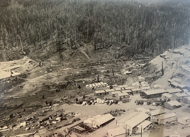
Photograph - Aerial View of Bogong Alpine Village
The images in the Bogong Village Collection were displayed in Bogong Jack’s Tavern for over 20 years and were donated to the Falls Creek Museum when the Tavern closed in 2021. In 1939, the State Electricity Commission of Victoria established a field headquarters at Bogong to house workers and their families for the Kiewa Hydroelectric Scheme which ran from the 1930s to the 1960s. The workmen's camp was originally started with tents and was called Junction Camp. By 1947, the village supported 300 workers and their families. It included 40 houses, a hostel for single staff, a post office, a police station, a medical centre, and a primary school. The staff hostel was known as Kiewa House. At the completion of the Scheme, in the 1960s, the village was opened to public/tourism use. In 1968 the Victorian Education Department acquired the camp buildings and four houses from the State Electricity Commission of Victoria to establish an Outdoor Education Centre which operated for over 50 years. The Kiewa Hydroelectric Scheme was privatized in the 1990s and sold to Southern Hydro, before being acquired by AGL in 2005. In 2023 the Grollo Group signed a 73 year sublease on Bogong Village and has plans for its redevelopment as a workers’ village.These images are significant because they capture the development of Bogong Village as an important element of the Kiewa Hydroelectric Scheme in Victoria.An aerial view of Bogong Village and surrounds, date unknown.bogong alpine village, bogong high plains, aerial photos bogong village -
 Falls Creek Historical Society
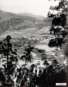
Photograph - Bogong Alpine Village 1940
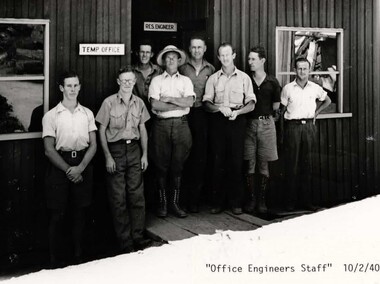
The images in the Bogong Village Collection were displayed in Bogong Jack’s Tavern for over 20 years and were donated to the Falls Creek Museum by the Liz Krien & the Bogong Village Trust Board when the Tavern closed in 2021. In 1939, the State Electricity Commission of Victoria established a field headquarters at Bogong to house workers and their families for the Kiewa Hydroelectric Scheme which ran from the 1930s to the 1960s. The workmen's camp was originally started with tents and was called Junction Camp. By 1947, the village supported 300 workers and their families. It included 40 houses, a hostel for single staff, a post office, a police station, a medical centre, and a primary school. The staff hostel was known as Kiewa House. At the completion of the Scheme, in the 1960s, the village was opened to public/tourism use. In 1968 the Victorian Education Department acquired the camp buildings and four houses from the State Electricity Commission of Victoria to establish an Outdoor Education Centre which operated for over 50 years. The Kiewa Hydroelectric Scheme was privatized in the 1990s and sold to Southern Hydro, before being acquired by AGL in 2005. In 2023 the Grollo Group signed a 73 year sublease on Bogong Village and has plans for its redevelopment as a workers’ village.These images are significant because they capture the development of Bogong Village as an important element of the Kiewa Hydroelectric Scheme in Victoria.A collection of 10 black and white images capturing the development of Bogong Alpine Village. They depict development of the new village, the surrounding area and some staff members during 1940.bogong alpine village, bogong 1940, bogong high plains -
 Falls Creek Historical Society
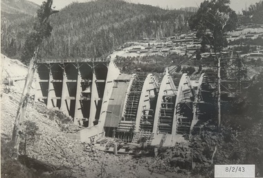
Photograph - Bogong Alpine Village 1943
The images in the Bogong Village Collection were displayed in Bogong Jack’s Tavern for over 20 years and were donated to the Falls Creek Museum when the Tavern closed in 2021. In 1939, the State Electricity Commission of Victoria established a field headquarters at Bogong to house workers and their families for the Kiewa Hydroelectric Scheme which ran from the 1930s to the 1960s. The workmen's camp was originally started with tents and was called Junction Camp. By 1947, the village supported 300 workers and their families. It included 40 houses, a hostel for single staff, a post office, a police station, a medical centre, and a primary school. The staff hostel was known as Kiewa House. At the completion of the Scheme, in the 1960s, the village was opened to public/tourism use. In 1968 the Victorian Education Department acquired the camp buildings and four houses from the State Electricity Commission of Victoria to establish an Outdoor Education Centre which operated for over 50 years. The Kiewa Hydroelectric Scheme was privatized in the 1990s and sold to Southern Hydro, before being acquired by AGL in 2005. In 2023 the Grollo Group signed a 73 year sublease on Bogong Village and has plans for its redevelopment as a workers’ village.These images are significant because they capture the development of Bogong Village as an important element of the Kiewa Hydroelectric Scheme in Victoria.A collection of seven black and white images capturing the development of Bogong Alpine Village and the Pretty Valley area during 1943.bogong alpine village, bogong high plains, bogong 1943 -
 Falls Creek Historical Society
Photograph - Bogong Alpine Village 1942
The images in the Bogong Village Collection were displayed in Bogong Jack’s Tavern for over 20 years and were donated to the Falls Creek Museum when the Tavern closed in 2021. In 1939, the State Electricity Commission of Victoria established a field headquarters at Bogong to house workers and their families for the Kiewa Hydroelectric Scheme which ran from the 1930s to the 1960s. The workmen's camp was originally started with tents and was called Junction Camp. By 1947, the village supported 300 workers and their families. It included 40 houses, a hostel for single staff, a post office, a police station, a medical centre, and a primary school. The staff hostel was known as Kiewa House. At the completion of the Scheme, in the 1960s, the village was opened to public/tourism use. In 1968 the Victorian Education Department acquired the camp buildings and four houses from the State Electricity Commission of Victoria to establish an Outdoor Education Centre which operated for over 50 years. The Kiewa Hydroelectric Scheme was privatized in the 1990s and sold to Southern Hydro, before being acquired by AGL in 2005. In 2023 the Grollo Group signed a 73 year sublease on Bogong Village and has plans for its redevelopment as a workers’ village.These images are significant because they capture the development of Bogong Village as an important element of the Kiewa Hydroelectric Scheme in Victoria.A collection of four black and white images capturing the development of Bogong Alpine Village and the Pretty Valley area during 1942.bogong alpine village, bogong high plains, bogong 1942 -
 Falls Creek Historical Society
Photograph - Bogong Alpine Village 1941
The images in the Bogong Village Collection were displayed in Bogong Jack’s Tavern for over 20 years and were donated to the Falls Creek Museum when the Tavern closed in 2021. In 1939, the State Electricity Commission of Victoria established a field headquarters at Bogong to house workers and their families for the Kiewa Hydroelectric Scheme which ran from the 1930s to the 1960s. The workmen's camp was originally started with tents and was called Junction Camp. By 1947, the village supported 300 workers and their families. It included 40 houses, a hostel for single staff, a post office, a police station, a medical centre, and a primary school. The staff hostel was known as Kiewa House. At the completion of the Scheme, in the 1960s, the village was opened to public/tourism use. In 1968 the Victorian Education Department acquired the camp buildings and four houses from the State Electricity Commission of Victoria to establish an Outdoor Education Centre which operated for over 50 years. The Kiewa Hydroelectric Scheme was privatized in the 1990s and sold to Southern Hydro, before being acquired by AGL in 2005. In 2023 the Grollo Group signed a 73 year sublease on Bogong Village and has plans for its redevelopment as a workers’ village.These images are significant because they capture the development of Bogong Village as an important element of the Kiewa Hydroelectric Scheme in Victoria.A collection of four black and white images capturing the development of Bogong Alpine Village. They depict development of the new village, the surrounding area and some staff members during 1941.bogong alpine village, bogong high plains, bogong 1941 -
 Lakes Entrance Historical Society
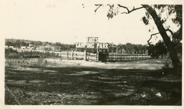
Photograph - Lakes Camping Park, Jemmeson Edie, 1928
This fully self contained camp park containing accommodation, general store, entertainment, Rotunda, petrol bowsers and community kitchen was the vision of Richard Bromby Whiter, who commenced the project in 1927. Water for gardening and sewerage supplied by an underground bore.Small format black and white photograph of the entrance to the planned Lakes Camping Park, fronting Roadknight Street. Shows sign at the rear of block on timber fence, other buildings in background. Lakes Entrance Victoriatourism, recreation, caravan parks -
 Wodonga & District Historical Society Inc
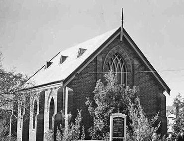
Photograph - First Presbyterian Church, Wodonga
Members of the Presbyterian faith were among the first settlers in the North-east of Victoria, and in the year 1842 the Presbytery of Melbourne requested the Rev. Peter Gunn, Minister of the Gaelic Church, Melbourne, to visit Presbyterians along the Murray River. This was the first of a series of annual visits, and was of a missionary nature. In May 1851, the Rev. David Hunter Ballantyne was appointed to the Wodonga district based out of Albury. In 1860 the Presbytery of Beechworth was formed, and from it two large presbyteries have grown - Wagga Wagga and Beechworth. In the early days the services at Wodonga were held in the old court house, which still stands. Wodonga Presbyterian Church continued as part of the Parish of Albury until the end of 1887, when it was placed under the administration of the Session of the Beechworth Church, with a home missionary in charge. Mr William Cooper was placed in charge for the first months, then Mr William Smith, a city missionary who had recently arrived from Scotland, was appointed. Mr Smith conducted a cordage factory at Stonleigh. He remained as missionary in charge for the next 10 years, and in that time the church steadily progressed. Plans were made for the erection of the building which now stands in High Street, Wodonga. Mr John Whan was a Founding Member of the Church and was appointed Sunday School Superintendent, an office which he held for 46 years, rendering extensive and valued service to the church and congregation. With a growing congregation and realising the challenges presented to the Church by changing conditions, land for a new church was sought. In September 1950 property was purchased in Nilmar Avenue in Wodonga and the new Presbyterian Church St Stephens became their new home. With the amalgamation of the Presbyterian and Methodist Churches, the new Church became the Uniting Church. The original Presbyterian Church was later sold to the Free Serbian Orthodox Church.These photographs are significant because they provide evidence of the changing nature of religious worship and groups in Wodonga.A collection of black and white photographic images depicting the first Presbyterian Church at Wodonga. The Church was later taken over by the Free Serbian Orthodox Church.presbyterian church, free serbian orthodox church, wodonga churches -
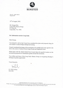 Bendigo Historical Society Inc.
Document - LONG GULLY HISTORY GROUP COLLECTION: LETTERS
BHS CollectionTwo letters from the City of Greater Bendigo to Mr. George Ellis. The first dated 15/8/2002 mentions the Council has considered plans and proposed site for a marker. It is mentioned to liaise with Mr. Sandy Ireland about the specific location. Signed Cr Willi Carney. The second letter, dated 6/11/2002 is an application for a building approval for a poppet Legs Monument. There are also two plans, Sheet 1 is Framing Sizes (Proposed) and Sheet 2 Base Details. Both sheets are dated July 02.bendigo, history, long gully history group, the long gully history group - letters, city of greater bendigo, george ellis, long gully history group, marker, sandy ireland, maurie betts, david turner