Showing 3660 items
matching landscaping
-
![View of the Township of Mt. Blackwood / [by] Nicholas Caire, circa 1876](/media/collectors/550653872162f11fb04854aa/items/57830cfbd0cdd1176c424e00/item-media/57830d7ad0cdd1176c428423/item-fit-380x285.jpg) Kew Historical Society Inc
Kew Historical Society IncPhotograph, Anglo-Australasian Photographic Company, View of the Township of Mt. Blackwood, c. 1876
Nicholas Caire was born on Guernsey in the Channel Islands in 1837. He arrived in Adelaide with his parents in about 1860. In 1867, following photographic journeys in Gippsland, he opened a studio in Adelaide. From 1870 to 1876 he lived and worked in Talbot in Central Victoria. In 1876 he purchased T. F. Chuck's studios in the Royal Arcade Melbourne. In 1885, following the introduction of dry plate photography, he began a series of landscape series, which were commercially successful. As a photographer, he travelled extensively through Victoria, photographing places few of his contemporaries had previously seen. He died in 1918. Reference: Jack Cato, 'Caire, Nicholas John (1837–1918)', Australian Dictionary of Biography.An original, rare photograph from the series 'Views of Victoria: General Series' by the photographer, Nicholas Caire (1837-1918). The series of 60 photographs that comprise the series was issued c. 1876 and reinforced a neo-Romantic view of the Australian landscape to which a growing nationalist movement would respond. Nicholas Caire was active as a photographer in Australia from 1858 until his death in 1918. His vision of the Australian bush and pioneer life had a counterpart in the works of Henry Lawson and other nationalist poets, authors and painters.‘View of the Township of Mt. Blackwood’ : Views of Victoria (General Series) No.42 : Albumen silver photograph | Photo on card with Title and Description on reverse | Mounted 24 x 30 cm; Photo 12 x 17 cm.On Reverse: ‘The locality which this illustration represents was formerly known as the Blackwood Forest, and has been the scene of considerable mining activity. The shallow alluvial diggings of the early days have given place to the deep sinking in search of reefs. This scene is characteristic of the wild appearance which many of the inland townships of Victoria represent.’nicholas caire (1837-1918), blackwood (vic), mount blackwood, landscape photography - victoria -
![View of the Township of Omeo / [by] Nicholas Caire, circa 1876](/media/collectors/550653872162f11fb04854aa/items/57830e80d0cdd1176c4335ca/item-media/57830eecd0cdd1176c43dd40/item-fit-380x285.jpg) Kew Historical Society Inc
Kew Historical Society IncPhotograph, Anglo-Australasian Photographic Company, View of the Township of Omeo, c. 1876
Nicholas Caire was born on Guernsey in the Channel Islands in 1837. He arrived in Adelaide with his parents in about 1860. In 1867, following photographic journeys in Gippsland, he opened a studio in Adelaide. From 1870 to 1876 he lived and worked in Talbot in Central Victoria. In 1876 he purchased T. F. Chuck's studios in the Royal Arcade Melbourne. In 1885, following the introduction of dry plate photography, he began a series of landscape series, which were commercially successful. As a photographer, he travelled extensively through Victoria, photographing places few of his contemporaries had previously seen. He died in 1918. Reference: Jack Cato, 'Caire, Nicholas John (1837–1918)', Australian Dictionary of Biography.An original, rare photograph from the series 'Views of Victoria: General Series' by the photographer, Nicholas Caire (1837-1918). The series of 60 photographs that comprise the series was issued c. 1876 and reinforced a neo-Romantic view of the Australian landscape to which a growing nationalist movement would respond. Nicholas Caire was active as a photographer in Australia from 1858 until his death in 1918. His vision of the Australian bush and pioneer life had a counterpart in the works of Henry Lawson and other nationalist poets, authors and painters.‘View of the township of Omeo’ : Views of Victoria (General Series) No.44 : Albumen silver photograph | Photo on card with Title and Description on reverse | Mounted 24 x 30 cm; Photo 12 x 17 cm.On Reverse: ‘The subject of this illustration is the most remote Township in the Colony of Victoria, being about 250 miles distant from Melbourne. It is situated on the Australian Alps, near Mt. Livingstone. The bed of the River, which is seen on the right-hand side of the picture, is one of the sources of the Mitchell River, which empties itself in the Gipps Land Lakes. This Township is frequently covered with snow in winter time, owing to its being several thousand feet above the level of the sea.’ nicholas caire (1837-1918), omeo (vic), gippsland, mount livingstone, australian alps -
![View on the Upper Buckland River / [by] Nicholas Caire, circa 1876](/media/collectors/550653872162f11fb04854aa/items/57830fc0d0cdd1176c450fda/item-media/57831013d0cdd1176c454bda/item-fit-380x285.jpg) Kew Historical Society Inc
Kew Historical Society IncPhotograph, Anglo-Australasian Photographic Company, View on the Upper Buckland River, c. 1876
Nicholas Caire was born on Guernsey in the Channel Islands in 1837. He arrived in Adelaide with his parents in about 1860. In 1867, following photographic journeys in Gippsland, he opened a studio in Adelaide. From 1870 to 1876 he lived and worked in Talbot in Central Victoria. In 1876 he purchased T. F. Chuck's studios in the Royal Arcade Melbourne. In 1885, following the introduction of dry plate photography, he began a series of landscape series, which were commercially successful. As a photographer, he travelled extensively through Victoria, photographing places few of his contemporaries had previously seen. He died in 1918. Reference: Jack Cato, 'Caire, Nicholas John (1837–1918)', Australian Dictionary of Biography.An original, rare photograph from the series 'Views of Victoria: General Series' by the photographer, Nicholas Caire (1837-1918). The series of 60 photographs that comprise the series was issued c. 1876 and reinforced a neo-Romantic view of the Australian landscape to which a growing nationalist movement would respond. Nicholas Caire was active as a photographer in Australia from 1858 until his death in 1918. His vision of the Australian bush and pioneer life had a counterpart in the works of Henry Lawson and other nationalist poets, authors and painters.‘View on the upper Buckland River’ : Views of Victoria (General Series) No.46 : Albumen silver photograph | Photo on card with Title and Description on reverse | Mounted 24 x 30 cm; Photo 12 x 17 cm.On Reverse: ‘The Buckland River is situated near the western extremity of the Australian Alps, and forms one of the sources of the Ovens River. Its watercourse is very shallow, except in flood time. Our illustration is taken on the upper portion of the River, near Reeve’s dam.’nicholas caire (1837-1918), buckland river (vic), landscape photography - victoria -
![Scene near Bright / [by] Nicholas Caire, circa 1876](/media/collectors/550653872162f11fb04854aa/items/578310d1d0cdd1176c462743/item-media/5783113fd0cdd1176c46de2e/item-fit-380x285.jpg) Kew Historical Society Inc
Kew Historical Society IncPhotograph, Anglo-Australasian Photographic Company, Scene near Bright, c. 1876
Nicholas Caire was born on Guernsey in the Channel Islands in 1837. He arrived in Adelaide with his parents in about 1860. In 1867, following photographic journeys in Gippsland, he opened a studio in Adelaide. From 1870 to 1876 he lived and worked in Talbot in Central Victoria. In 1876 he purchased T. F. Chuck's studios in the Royal Arcade Melbourne. In 1885, following the introduction of dry plate photography, he began a series of landscape series, which were commercially successful. As a photographer, he travelled extensively through Victoria, photographing places few of his contemporaries had previously seen. He died in 1918. Reference: Jack Cato, 'Caire, Nicholas John (1837–1918)', Australian Dictionary of Biography.An original, rare photograph from the series 'Views of Victoria: General Series' by the photographer, Nicholas Caire (1837-1918). The series of 60 photographs that comprise the series was issued c. 1876 and reinforced a neo-Romantic view of the Australian landscape to which a growing nationalist movement would respond. Nicholas Caire was active as a photographer in Australia from 1858 until his death in 1918. His vision of the Australian bush and pioneer life had a counterpart in the works of Henry Lawson and other nationalist poets, authors and painters.‘Scene near Bright’ : Views of Victoria (General Series) No.47 : Albumen silver photograph | Photo on card with Title and Description on reverse | Mounted 24 x 30 cm; Photo 12 x 17 cm.On Reverse: ‘The subject of this illustration is taken on the road to Grouber’s, near the township of Bright, in the Beechworth District. The scenery on the rivers and creeks which surround this township is of a very romantic and picturesque description.’nicholas caire (1837-1918), bright (vic), landscape photography - victoria -
![The Bend of the Yarra at Studley Park / [by] Nicholas Caire, circa 1876](/media/collectors/550653872162f11fb04854aa/items/5783120ed0cdd1176c47d8c8/item-media/57831278d0cdd1176c4805d6/item-fit-380x285.jpg) Kew Historical Society Inc
Kew Historical Society IncPhotograph, Anglo-Australasian Photographic Company, The Bend of the Yarra at Studley Park, c. 1876
Nicholas Caire was born on Guernsey in the Channel Islands in 1837. He arrived in Adelaide with his parents in about 1860. In 1867, following photographic journeys in Gippsland, he opened a studio in Adelaide. From 1870 to 1876 he lived and worked in Talbot in Central Victoria. In 1876 he purchased T. F. Chuck's studios in the Royal Arcade Melbourne. In 1885, following the introduction of dry plate photography, he began a series of landscape series, which were commercially successful. As a photographer, he travelled extensively through Victoria, photographing places few of his contemporaries had previously seen. He died in 1918. Reference: Jack Cato, 'Caire, Nicholas John (1837–1918)', Australian Dictionary of Biography.An original, rare photograph from the series 'Views of Victoria: General Series' by the photographer, Nicholas Caire (1837-1918). The series of 60 photographs that comprise the series was issued c. 1876 and reinforced a neo-Romantic view of the Australian landscape to which a growing nationalist movement would respond. Nicholas Caire was active as a photographer in Australia from 1858 until his death in 1918. His vision of the Australian bush and pioneer life had a counterpart in the works of Henry Lawson and other nationalist poets, authors and painters.‘The Bend of the Yarra at Studley Park’ : Views of Victoria (General Series) No.49 : Albumen silver photograph | Photo on card with Title and Description on reverse | Mounted 24 x 30 cm; Photo 12 x 17 cm.On Reverse: The subject of the present illustration is taken from near the Kew Road, on the Park-hill side of the Yarra. The curve of the River at this and other parts of the Park represents a gigantic letter S. It is a remarkable fact that the hilly side of the River is covered with a mass of foliage of various descriptions, from the stately gum tree to the stunted wattle, whilst the opposite side of flat country has scarcely a shrub to be seen any where.’nicholas caire (1837-1918), studley park, yarra river, kew, landscape photography - victoria -
![Aboriginal Natives of Victoria Hop Gathering / [by] Nicholas Caire, circa 1876](/media/collectors/550653872162f11fb04854aa/items/5783136dd0cdd1176c497cca/item-media/5783140ad0cdd1176c4a76ef/item-fit-380x285.jpg) Kew Historical Society Inc
Kew Historical Society IncPhotograph, Anglo-Australasian Photographic Company, Aboriginal Natives of Victoria Hop Gathering, c. 1876
Nicholas Caire was born on Guernsey in the Channel Islands in 1837. He arrived in Adelaide with his parents in about 1860. In 1867, following photographic journeys in Gippsland, he opened a studio in Adelaide. From 1870 to 1876 he lived and worked in Talbot in Central Victoria. In 1876 he purchased T. F. Chuck's studios in the Royal Arcade Melbourne. In 1885, following the introduction of dry plate photography, he began a series of landscape series, which were commercially successful. As a photographer, he travelled extensively through Victoria, photographing places few of his contemporaries had previously seen. He died in 1918. Reference: Jack Cato, 'Caire, Nicholas John (1837–1918)', Australian Dictionary of Biography.An original, rare photograph from the series 'Views of Victoria: General Series' by the photographer, Nicholas Caire (1837-1918). The 60 photographs that comprise the series were issued c. 1876 and reinforced a neo-Romantic view of the Australian landscape to which a growing nationalist movement would respond. Nicholas Caire was active as a photographer in Australia from 1858 until his death in 1918. His vision of the Australian bush and pioneer life had a counterpart in the works of Henry Lawson and other nationalist poets, authors and painters.Aboriginal Natives of Victoria hop gathering’ : Views of Victoria (General Series) No.50 : Albumen silver photograph | Photo on card with Title and Description on reverse | Mounted 24 x 30 cm; Photo 12 x 17 cm.On Reverse: ‘The growth of Hops has of late years occupied the attention of farmers in most of the colonies, and with the most encouraging results. It has been introduced with considerable success on most of the Aboriginal Stations in Victoria. Our illustration represents a group of natives gathering Hops on the Station at Bairnsdale, in Gipps Land.’nicholas caire (1837-1918), bairnsdale, aborigines, landscape photography, first peoples, aboriginal and torres straight islander -
![Jebb's Pool, on the Erskine River, Near Lorne / [by] Nicholas Caire, circa 1876](/media/collectors/550653872162f11fb04854aa/items/57831524d0cdd1176c4c6452/item-media/5783159dd0cdd1176c4d1cd3/item-fit-380x285.jpg) Kew Historical Society Inc
Kew Historical Society IncPhotograph, Anglo-Australasian Photographic Company, Jebb's Pool, on the Erskine River, Near Lorne, c. 1876
Nicholas Caire was born on Guernsey in the Channel Islands in 1837. He arrived in Adelaide with his parents in about 1860. In 1867, following photographic journeys in Gippsland, he opened a studio in Adelaide. From 1870 to 1876 he lived and worked in Talbot in Central Victoria. In 1876 he purchased T. F. Chuck's studios in the Royal Arcade Melbourne. In 1885, following the introduction of dry plate photography, he began a series of landscape series, which were commercially successful. As a photographer, he travelled extensively through Victoria, photographing places few of his contemporaries had previously seen. He died in 1918. Reference: Jack Cato, 'Caire, Nicholas John (1837–1918)', Australian Dictionary of Biography.An original, rare photograph from the series 'Views of Victoria: General Series' by the photographer, Nicholas Caire (1837-1918). The 60 photographs that comprise the series were issued c. 1876 and reinforced a neo-Romantic view of the Australian landscape to which a growing nationalist movement would respond. Nicholas Caire was active as a photographer in Australia from 1858 until his death in 1918. His vision of the Australian bush and pioneer life had a counterpart in the works of Henry Lawson and other nationalist poets, authors and painters.'Jebb’s Pool, on the Erskine River, near Lorne’ : Views of Victoria (General Series) No.51 : Albumen silver photograph | Photo on card with Title and Description on reverse | Mounted 24 x 30 cm; Photo 12 x 17 cm.On Reverse: ‘Jebb’s Pool is situated about four miles from the township of Lorne, and is so called in consequence of a gentleman named Jebb, whilst crossing the cataract, having fallen in and was swept down by the current into a whirlpool which is continually in motion, owing to the particular formation of the river and the powerful current of water. The depth of water in the pool must be considerable, as but for the timely assistance rendered his life would have been sacrificed.’nicholas caire (1837-1918), lorne (vic), erskine river (vic), landscape photography - victoria -
![The Erskine River Waterfall / [by] Nicholas Caire, circa 1876](/media/collectors/550653872162f11fb04854aa/items/57831695d0cdd1176c4f24d8/item-media/57831701d0cdd1176c4f989a/item-fit-380x285.jpg) Kew Historical Society Inc
Kew Historical Society IncPhotograph, Anglo-Australasian Photographic Company, The Erskine River Waterfall, c. 1876
Nicholas Caire was born on Guernsey in the Channel Islands in 1837. He arrived in Adelaide with his parents in about 1860. In 1867, following photographic journeys in Gippsland, he opened a studio in Adelaide. From 1870 to 1876 he lived and worked in Talbot in Central Victoria. In 1876 he purchased T. F. Chuck's studios in the Royal Arcade Melbourne. In 1885, following the introduction of dry plate photography, he began a series of landscape series, which were commercially successful. As a photographer, he travelled extensively through Victoria, photographing places few of his contemporaries had previously seen. He died in 1918. Reference: Jack Cato, 'Caire, Nicholas John (1837–1918)', Australian Dictionary of Biography.An original, rare photograph from the series 'Views of Victoria: General Series' by the photographer, Nicholas Caire (1837-1918). The 60 photographs that comprise the series were issued c. 1876 and reinforced a neo-Romantic view of the Australian landscape to which a growing nationalist movement would respond. Nicholas Caire was active as a photographer in Australia from 1858 until his death in 1918. His vision of the Australian bush and pioneer life had a counterpart in the works of Henry Lawson and other nationalist poets, authors and painters.‘The Erskine River waterfall’ : Views of Victoria (General Series) No.52 : Albumen silver photograph | Photo on card with Title and Description on reverse | Mounted 24 x 30 cm; Photo 12 x 17 cm.On Reverse: ‘The River Erskine, which empties itself into Loutitt Bay, is noted for the grandeur of its scenery. Its sources, owing to the impenetrability of the bush and the mountainous nature of the country, are unknown. They may eventually be traced a long way into the Cape Otway Ranges. An idea of the difficulty with which the present very beautiful illustration was obtained may be gained from the fact that it took our assistants, several days to convey the apparatus a distance of six miles and back. The depth of the fall is 150 feet. The foliage as seen comprises the very rare staghorn tree, the myrtle, the dogwood tree, and ferns.’nicholas caire (1837-1918), lorne (vic), erskine river (vic), landscape photography -
![Crystal Brook, in the Cape Otway Ranges / [by] Nicholas Caire, circa 1876](/media/collectors/550653872162f11fb04854aa/items/578338b0d0cdd1176c64c320/item-media/57833931d0cdd1176c64fa91/item-fit-380x285.jpg) Kew Historical Society Inc
Kew Historical Society IncPhotograph, Anglo-Australasian Photographic Company, Crystal Brook, in the Cape Otway Ranges, c. 1876
Nicholas Caire was born on Guernsey in the Channel Islands in 1837. He arrived in Adelaide with his parents in about 1860. In 1867, following photographic journeys in Gippsland, he opened a studio in Adelaide. From 1870 to 1876 he lived and worked in Talbot in Central Victoria. In 1876 he purchased T. F. Chuck's studios in the Royal Arcade Melbourne. In 1885, following the introduction of dry plate photography, he began a series of landscape series, which were commercially successful. As a photographer, he travelled extensively through Victoria, photographing places few of his contemporaries had previously seen. He died in 1918. Reference: Jack Cato, 'Caire, Nicholas John (1837–1918)', Australian Dictionary of Biography.An original, rare photograph from the series 'Views of Victoria: General Series' by the photographer, Nicholas Caire (1837-1918). The 60 photographs that comprise the series were issued c. 1876 and reinforced a neo-Romantic view of the Australian landscape to which a growing nationalist movement would respond. Nicholas Caire was active as a photographer in Australia from 1858 until his death in 1918. His vision of the Australian bush and pioneer life had a counterpart in the works of Henry Lawson and other nationalist poets, authors and painters.‘Crystal Brook, in the Cape Otway Ranges’ : Views of Victoria (General Series) No.53 : Albumen silver photograph | Photo on card with Title and Description on reverse | Mounted 24 x 30 cm; Photo 12 x 17 cm.On Reverse: 'The subject of the present illustration was discovered by one of our operators exploring the Cape in search of scenery. It is situated about four miles from the coast, and is surrounded by dense foliage on the one side, and rocky boulders on the other. This spot being unknown to the settlers, the title we have given to it is highly suggestive of such a romantic and secluded spot.'nicholas caire (1837-1918), landscape photography -
![Sylvan Dell, near Loutitt Bay / [by] Nicholas Caire, circa 1876](/media/collectors/550653872162f11fb04854aa/items/578339fad0cdd1176c655e0d/item-media/57833b11d0cdd1176c662c00/item-fit-380x285.jpg) Kew Historical Society Inc
Kew Historical Society IncPhotograph, Anglo-Australasian Photographic Company, Sylvan Dell, near Loutitt Bay, c. 1876
Nicholas Caire was born on Guernsey in the Channel Islands in 1837. He arrived in Adelaide with his parents in about 1860. In 1867, following photographic journeys in Gippsland, he opened a studio in Adelaide. From 1870 to 1876 he lived and worked in Talbot in Central Victoria. In 1876 he purchased T. F. Chuck's studios in the Royal Arcade Melbourne. In 1885, following the introduction of dry plate photography, he began a series of landscape series, which were commercially successful. As a photographer, he travelled extensively through Victoria, photographing places few of his contemporaries had previously seen. He died in 1918. Reference: Jack Cato, 'Caire, Nicholas John (1837–1918)', Australian Dictionary of Biography.An original, rare photograph from the series 'Views of Victoria: General Series' by the photographer, Nicholas Caire (1837-1918). The 60 photographs that comprise the series were issued c. 1876 and reinforced a neo-Romantic view of the Australian landscape to which a growing nationalist movement would respond. Nicholas Caire was active as a photographer in Australia from 1858 until his death in 1918. His vision of the Australian bush and pioneer life had a counterpart in the works of Henry Lawson and other nationalist poets, authors and painters.'Sylvan Dell, near Loutitt Bay’ : Views of Victoria (General Series) No.54 : Albumen silver photograph | Photo on card with Title and Description on reverse | Mounted 24 x 30 cm; Photo 12 x 17 cm.On Reverse: ‘Sylvan Dell is one of the favourite resorts for visitors who are in search of the romantic. The peculiarly slender and upright foliage which is seen near the foreground is that of the myrtle tree. Dogwood, brush, staghorn, ferns, and wattle make up the background. Considerable difficulty is experienced in reaching the Dell, in consequence of the precipitous hills and dense scrub which surround it.’nicholas caire (1837-1918), lorne (vic), landscape photography -
![Straus’ Falls, Cape Otway Ranges / [by] Nicholas Caire, circa 1876](/media/collectors/550653872162f11fb04854aa/items/57833e2ad0cdd1176c6791eb/item-media/57833ea7d0cdd1176c67b9d8/item-fit-380x285.jpg) Kew Historical Society Inc
Kew Historical Society IncPhotograph, Anglo-Australasian Photographic Company, Straus’ Falls, Cape Otway Ranges, c. 1876
Nicholas Caire was born on Guernsey in the Channel Islands in 1837. He arrived in Adelaide with his parents in about 1860. In 1867, following photographic journeys in Gippsland, he opened a studio in Adelaide. From 1870 to 1876 he lived and worked in Talbot in Central Victoria. In 1876 he purchased T. F. Chuck's studios in the Royal Arcade Melbourne. In 1885, following the introduction of dry plate photography, he began a series of landscape series, which were commercially successful. As a photographer, he travelled extensively through Victoria, photographing places few of his contemporaries had previously seen. He died in 1918. Reference: Jack Cato, 'Caire, Nicholas John (1837–1918)', Australian Dictionary of Biography.An original, rare photograph from the series 'Views of Victoria: General Series' by the photographer, Nicholas Caire (1837-1918). The 60 photographs that comprise the series were issued c. 1876 and reinforced a neo-Romantic view of the Australian landscape to which a growing nationalist movement would respond. Nicholas Caire was active as a photographer in Australia from 1858 until his death in 1918. His vision of the Australian bush and pioneer life had a counterpart in the works of Henry Lawson and other nationalist poets, authors and painters.‘Straus’ Falls, Cape Otway Ranges’ : Views of Victoria (General Series) No.55 : Albumen silver photograph | Photo on card with Title and Description on reverse | Mounted 24 x 30 cm; Photo 12 x 17 cm.On Reverse: ‘These Falls were discovered some time since by a gentleman named Straus, and were so named in memory of him. They comprise a succession of falls, rapids, and cataracts varying from 10 feet to 60 feet, making a total of 250 feet from the fall to the bed of the stream. These waters probably form a tributary to one of the adjacent rivers.’nicholas caire (1837-1918), landscape photography -
![Mount St. George, Addis Bay / [by] Nicholas Caire, circa 1876](/media/collectors/550653872162f11fb04854aa/items/57833f9fd0cdd1176c6828f5/item-media/57833ffdd0cdd1176c685980/item-fit-380x285.jpg) Kew Historical Society Inc
Kew Historical Society IncPhotograph, Anglo-Australasian Photographic Company, Mount St. George, Addis Bay, c. 1876
Nicholas Caire was born on Guernsey in the Channel Islands in 1837. He arrived in Adelaide with his parents in about 1860. In 1867, following photographic journeys in Gippsland, he opened a studio in Adelaide. From 1870 to 1876 he lived and worked in Talbot in Central Victoria. In 1876 he purchased T. F. Chuck's studios in the Royal Arcade Melbourne. In 1885, following the introduction of dry plate photography, he began a series of landscape series, which were commercially successful. As a photographer, he travelled extensively through Victoria, photographing places few of his contemporaries had previously seen. He died in 1918. Reference: Jack Cato, 'Caire, Nicholas John (1837–1918)', Australian Dictionary of Biography.An original, rare photograph from the series 'Views of Victoria: General Series' by the photographer, Nicholas Caire (1837-1918). The 60 photographs that comprise the series were issued c. 1876 and reinforced a neo-Romantic view of the Australian landscape to which a growing nationalist movement would respond. Nicholas Caire was active as a photographer in Australia from 1858 until his death in 1918. His vision of the Australian bush and pioneer life had a counterpart in the works of Henry Lawson and other nationalist poets, authors and painters.‘Mount St. George, Addis Bay’ : Views of Victoria (General Series) No.56 : Albumen silver photograph | Photo on card with Title and Description on reverse | Mounted 24 x 30 cm; Photo 12 x 17 cm.On Reverse: ‘Addis Bay is situated to the north-east of Appollo Bay, and very near Cape Patten. This mountain is 6,000 feet high, and commands one of the finest views on the Cape Otway Ranges. The ascent is a somewhat difficult one, but visitors to this locality not unfrequently make this a favourite outing.’nicholas caire (1837-1918), landscape photography -
![View of the township of Golden Square / [by] Nicholas Caire, circa 1876](/media/collectors/550653872162f11fb04854aa/items/578340aed0cdd1176c6899f4/item-media/5783411dd0cdd1176c68c568/item-fit-380x285.jpg) Kew Historical Society Inc
Kew Historical Society IncPhotograph, Anglo-Australasian Photographic Company, View of the township of Golden Square, c. 1876
Nicholas Caire was born on Guernsey in the Channel Islands in 1837. He arrived in Adelaide with his parents in about 1860. In 1867, following photographic journeys in Gippsland, he opened a studio in Adelaide. From 1870 to 1876 he lived and worked in Talbot in Central Victoria. In 1876 he purchased T. F. Chuck's studios in the Royal Arcade Melbourne. In 1885, following the introduction of dry plate photography, he began a series of landscape series, which were commercially successful. As a photographer, he travelled extensively through Victoria, photographing places few of his contemporaries had previously seen. He died in 1918. Reference: Jack Cato, 'Caire, Nicholas John (1837–1918)', Australian Dictionary of Biography.An original, rare photograph from the series 'Views of Victoria: General Series' by the photographer, Nicholas Caire (1837-1918). The 60 photographs that comprise the series were issued c. 1876 and reinforced a neo-Romantic view of the Australian landscape to which a growing nationalist movement would respond. Nicholas Caire was active as a photographer in Australia from 1858 until his death in 1918. His vision of the Australian bush and pioneer life had a counterpart in the works of Henry Lawson and other nationalist poets, authors and painters.‘View of the township of Golden Square’ : Views of Victoria (General Series) No.57 : Albumen silver photograph | Photo on card with Title and Description on reverse | Mounted 24 x 30 cm; Photo 12 x 17 cm.On Reverse: ‘This Township is situated in the Bendigo district, on the road to Castlemaine, and although it is of little importance as a business town, is nevertheless of large importance in consequence of the great number of Quartz Reefs it contains. Almost every house is undermined, and large fortunes have been made by the proprietors. The Church in the distance is that of the Wesleyan body. It was in this township that gold was first discovered in the district of Bendigo.’nicholas caire (1837-1918), golden square (vic), bendigo (vic), gold mining, landscape photography - victoria -
![The Boulders on the Erskine River / [by] Nicholas Caire, circa 1876](/media/collectors/550653872162f11fb04854aa/items/5783420cd0cdd1176c6a3ffd/item-media/57834272d0cdd1176c6ac3f1/item-fit-380x285.jpg) Kew Historical Society Inc
Kew Historical Society IncPhotograph, Anglo-Australasian Photographic Company, The Boulders on the Erskine River, c. 1876
Nicholas Caire was born on Guernsey in the Channel Islands in 1837. He arrived in Adelaide with his parents in about 1860. In 1867, following photographic journeys in Gippsland, he opened a studio in Adelaide. From 1870 to 1876 he lived and worked in Talbot in Central Victoria. In 1876 he purchased T. F. Chuck's studios in the Royal Arcade Melbourne. In 1885, following the introduction of dry plate photography, he began a series of landscape series, which were commercially successful. As a photographer, he travelled extensively through Victoria, photographing places few of his contemporaries had previously seen. He died in 1918. Reference: Jack Cato, 'Caire, Nicholas John (1837–1918)', Australian Dictionary of Biography.An original, rare photograph from the series 'Views of Victoria: General Series' by the photographer, Nicholas Caire (1837-1918). The 60 photographs that comprise the series were issued c. 1876 and reinforced a neo-Romantic view of the Australian landscape to which a growing nationalist movement would respond. Nicholas Caire was active as a photographer in Australia from 1858 until his death in 1918. His vision of the Australian bush and pioneer life had a counterpart in the works of Henry Lawson and other nationalist poets, authors and painters.‘The boulders on the Erskine River’ : Views of Victoria (General Series) No.58 : Albumen silver photograph | Photo on card with Title and Description on reverse | Mounted 24 x 30 cm; Photo 12 x 17 cm.On Reverse: ‘For a distance of several miles this river runs its course over a granite bed, and is interrupted frequently by immense Boulders, which causes the stream to be broken up into rivulets, pools, rapids, falls, cataracts, &c. Many of these massive blocks of granite weigh from 40 to 50 tons. In the mid-distance of the present illustration, several of these great blocks can be seen obstructing the river in its course.’nicholas caire (1837-1918), erskine river, lorne (vic), landscape photography - victoria -
![Township of Lorne, and Loutitt Bay / [by] Nicholas Caire, circa 1876](/media/collectors/550653872162f11fb04854aa/items/5783458ad0cdd1176c6f0c78/item-media/578345eed0cdd1176c6f852b/item-fit-380x285.jpg) Kew Historical Society Inc
Kew Historical Society IncPhotograph, Anglo-Australasian Photographic Company, Township of Lorne, and Loutitt Bay, c. 1876
Nicholas Caire was born on Guernsey in the Channel Islands in 1837. He arrived in Adelaide with his parents in about 1860. In 1867, following photographic journeys in Gippsland, he opened a studio in Adelaide. From 1870 to 1876 he lived and worked in Talbot in Central Victoria. In 1876 he purchased T. F. Chuck's studios in the Royal Arcade Melbourne. In 1885, following the introduction of dry plate photography, he began a series of landscape series, which were commercially successful. As a photographer, he travelled extensively through Victoria, photographing places few of his contemporaries had previously seen. He died in 1918. Reference: Jack Cato, 'Caire, Nicholas John (1837–1918)', Australian Dictionary of Biography.An original, rare photograph from the series 'Views of Victoria: General Series' by the photographer, Nicholas Caire (1837-1918). The 60 photographs that comprise the series were issued c. 1876 and reinforced a neo-Romantic view of the Australian landscape to which a growing nationalist movement would respond. Nicholas Caire was active as a photographer in Australia from 1858 until his death in 1918. His vision of the Australian bush and pioneer life had a counterpart in the works of Henry Lawson and other nationalist poets, authors and painters.‘Township of Lorne, and Loutitt Bay’ : Views of Victoria (General Series) No.60 : Albumen silver photograph | Photo on card with Title and Description on reverse | Mounted 24 x 30 cm; Photo 12 x 17 cm.On Reverse: ‘Loutitt Bay is fast becoming one of the most fashionable Watering-places in Victoria, partly from its easy access by Rail, combined with the magnificent scenery to be found in the Cape Otway Ranges, and the very moderate charges of the houses of accommodation. The large house near the foreground is that of Mr. Mountjoy, which is a Restaurant. Duncan’s Hotel can be seen in the distance, on the brow of the hill.’nicholas caire (1837-1918), lorne (vic), duncan's hotel, loutitt bay, landscape photography - victoria -
![Cumberland Creek, near Point Sturt / [by] Nicholas Caire, circa 1876](/media/collectors/550653872162f11fb04854aa/items/57834713d0cdd1176c71111b/item-media/57834799d0cdd1176c71e113/item-fit-380x285.jpg) Kew Historical Society Inc
Kew Historical Society IncPhotograph, Anglo-Australasian Photographic Company, Cumberland Creek, near Point Sturt, c. 1876
Nicholas Caire was born on Guernsey in the Channel Islands in 1837. He arrived in Adelaide with his parents in about 1860. In 1867, following photographic journeys in Gippsland, he opened a studio in Adelaide. From 1870 to 1876 he lived and worked in Talbot in Central Victoria. In 1876 he purchased T. F. Chuck's studios in the Royal Arcade Melbourne. In 1885, following the introduction of dry plate photography, he began a series of landscape series, which were commercially successful. As a photographer, he travelled extensively through Victoria, photographing places few of his contemporaries had previously seen. He died in 1918. Reference: Jack Cato, 'Caire, Nicholas John (1837–1918)', Australian Dictionary of Biography.An original, rare photograph from the series 'Views of Victoria: General Series' by the photographer, Nicholas Caire (1837-1918). The 60 photographs that comprise the series were issued c. 1876 and reinforced a neo-Romantic view of the Australian landscape to which a growing nationalist movement would respond. Nicholas Caire was active as a photographer in Australia from 1858 until his death in 1918. His vision of the Australian bush and pioneer life had a counterpart in the works of Henry Lawson and other nationalist poets, authors and painters.‘Cumberland Creek, near Point Sturt’ : Views of Victoria (General Series) No.59 : Albumen silver photograph | Photo on card with Title and Description on reverse | Mounted 24 x 30 cm; Photo 12 x 17 cm.On Reverse: ‘The Cumberland Creek is so named from the close resemblance it bears to the place bearing that name in the mother country. The present illustration represents the precipices and hills which surround the Cumberland Creek. The soil around the hills is mostly sandstone rubble, hence the only vegetation identical with the spot is the inevitable sword grass and salt scrub, which frequently exist where no other vegetation can be found.’nicholas caire (1837-1918), landscape photography -
 Federation University Art Collection
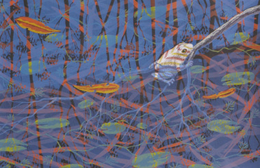
Work on paper - Printmaking - Screenprint, Lin Onus, 'Garkman' by Lin Onus, 1991
Lin ONUS (1948-1996) Lin Onus was integral to the recognition of Aboriginal art in the contemporary Australian art landscape. His work expresses the dynamism of living culture; Onus was a prominent figure in renegotiating the history of colonial and Aboriginal Australian. An early influence of this dedication was his father, who was the founder of the Aboriginal Advancement League in Victoria and a maker of artefacts. As a young boy Onus was subsequently exposed to visiting Aboriginal artists and assisted his father in decorating artefacts. His painting Barmah Forest won the Aboriginal Heritage Award in 1994; Onus also received a Member of the Order of Australia “for service to the arts as a painter and sculptor and the other promotion of Aboriginal artists and their work.” (https://www.portjacksonpress.com.au/artists/lin-onus)Unframed colour screenprint with a limited edition of 60.lin onus, frogs, aboriginal, screenprint, printmaking, gippsland campus, print council australia -
![Royal Australian Nursing Federation campaign badge, [1986?]](/media/collectors/5bb42dc221eaf31100db1d3b/items/5c4928d121ea731428168726/item-media/5c4928da21ea731428169161/item-fit-380x285.jpg) Australian Nursing & Midwifery Federation
Australian Nursing & Midwifery FederationRoyal Australian Nursing Federation campaign badge, [1986?]
Distributed to nurses during campaigning for improved wages and working conditions in the 1980s, possibly during the historic 1986 Victorian 50-day nurses strike. 'Charge Nurse' refers to a Nurse Manager, and is less commonly used in Australia presently (it is still widely used in North America). The badge's message aims to inform the public that highly experienced and skilled nurses are leaving the profession due to inadequate wages and poor working conditions. The Royal Australian Nursing Federation (RANF) became the Australian Nursing Federation in 1989, suggesting that this button is from the late 1980s. Similar to the badges worn in this photo [https://stories.anmfvic.asn.au/86strike/media/2560-1440-landscape-sec2-contentb-hr_logwf7a.jpg] from 1986 (see individual on the far right).Circular white and blue plastic badge. Silver metal, plastic-coated, with safety pin fastener adhered to back. Badge printed with 'I used to be a Charge Nurse' and 'R.A.N.F. [Royal Australian Nursing Federation] Vic. [Victorian] Branch'.nursing, nurses, industrial action, strike action, unionism, trade unions, badges, buttons, pins, campaigning, 1986 victorian nurses strike, labour history, royal australian nursing federation, victoria, australia -
 Warrnambool and District Historical Society Inc.
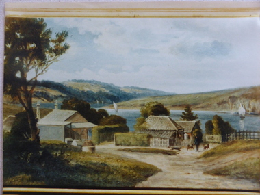
Photograph, Old Lyndoch - Photograph of Painting, Late 19th century (original painting); late 20th century (photograph of painting)
This is a photograph of a painting by the noted artist George Webb (1861-1949). Webb was best known for his portraits of civic dignitaries in Melbourne and Adelaide but he also produced many landscapes and seascapes. Some of these feature Warrnambool landmarks as he married, in the late 1890s, Christina Lake, the step-daughter of George Rolfe who owned the property known as ‘Lyndoch’, near the mouth of the Hopkins River. Webb painted the early cottages at ‘Old Lyndoch’ using a photograph taken some time earlier. The painting was given to Dick Allan, the chauffeur in the employ of Florence Lake, Christina’s sister. Florence Lake owned and resided at Lyndoch after her parents’ death. Dick Allan’s son, living in Tasmania, acquired the painting and Les O’Callaghan obtained the photograph of the painting from him. Although this is only a photograph of an original painting, it is of some considerable importance as the painting has great historical significance and this is the only representation we have of it. The man in the photograph represents George Rolfe and the story of Rolfe and his ownership and development of the property of Lyndoch is an important one in Warrnambool’s history. The original by George Webb is also an important work of art in its own right.This is a colour photograph of a painting. The frame of the original painting can be seen at the bottom of the photograph. The photograph is in on old frame which has two wooden edgings with the outer one having an ornate gold plaster edging and an inner one with a gold velvet insert next to the glass. The ornate gold plaster has a piece missing near the top left hand corner. The photograph is set into a gold-coloured wooden frame inside the glass. The photograph is mounted onto cardboard and covered with cardboard at the back with a small piece of wood attached (from the original frame). The backing is nailed on. lyndoch, george webb, george rolfe -
 Eltham District Historical Society Inc
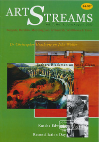
Journal, Peter Doughtery, ArtStreams: Banyule, Darebin, Manningham, Nillumbik, Whittlesea & Yarra; Vol. 7, No. 3, Jul-Aug 2002, 2002
Vol. 7, No. 3, Jul-Aug 2002 CONTENTS Comment 2 Home Country: The Art of John Waller 3 by Dr Christopher Heathcote Short Story: Meeting People Andrew Hutchinson 7 Strange Memories Barbara Blackman on the art of Anna Glynn 10 Walking the Talk 12 Reconciliation in Eltham World Environment Day 13 Poetry news and reviews 14 John Jenkins Australian Classical Music 15 Elizabeth Scarlett Short Story: The Thinkers Library 16 Trevor Hay CD Reviews Kerri Simpson, Brian Brown 22 Book Review Ecological Pioneers 24 Coffee 25 Australian Landscape Conference 26 How many birds is that? 28 Artin' About 29 Wining & Dining 30 Artin' About 32 "Peter Dougherty has been involved in the local art scene for many years. As publisher and editor of the arts magazine Artstreams, his comments on the various branches of the arts are widely respected. His "The Arts" column in the Diamond Valley Leader presents a brief summary for a much wider cross section of the local community. Peter also operates his own gallery and the Artstreams Cafe at the St Andrews market. Peter has a wealth of knowledge about present day and historical aspects of local art and artists." - Eltham District Historical Society Newsletter No. 161, March 2005Colour front and back cover with feature articles and literary pieces with photographs and advertisements printed in black and white. 36 pages, 30 cm. Vol. 1, no. 1 (Nov. 1996) - Vol. 10, no. 5 (summer ed. 2005/06) art streams, winter in banyule, john waller, bundoora homestead, willy wonka's ice cream gourmet food, bibby's bahnhof cafe, eltham fullife pharmacy, andrew hutchinson, bulleen art & garden centre, dynamic vegies, montsalvat, anna glynn, aboriginal reconciliation, marg woiwod, mick woiwod, andrew ross museum, trevor hay, st andrews hotel, chris pittard, mary-lou pittard, eltham wiregrass gallery, thompson's pharmacy, heide museum of modern art -
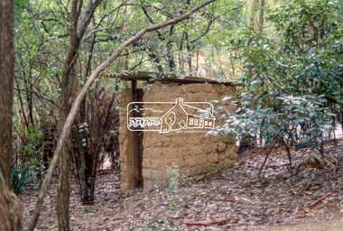
 Eltham District Historical Society Inc
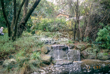
Slide - Photograph, Gordon Ford garden, "Fulling", Pitt Street, Eltham, 23 May 1993
"Fulling", pronounced Fu-elling, the 'display home' of Gordon Ford landscape designer and consultant. From 1945 he transformed one and a half acres of treeless grassland into a splendid bush garden complete with a waterfall and ponds. He used sawdust and wood shavings as a base for the bush floor. The 1993 Eltham Heritage Tour was enjoyed by a busload of members of the Historical Society on a fine, calm day, Sunday May 23rd. Between 10.00 am and 4.30 pm, except for a brief lunch stop at the Eltham Living and Learning Centre, members passed about thirty places of local interest and others recommended for the Historic Buildings Register and the Register of the National Estate. A number of significant trees and buildings were also highlighted along with the opportunity to explored some of the properties.35mm colour positive transparency (1 of 24) Mount - Kodak Kodachromeactivities, shire of eltham historical society, heritage excursion, eltham, fulling, gordon ford garden, pitt street -
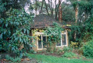
 Eltham District Historical Society Inc
Slide - Photograph, Gordon Ford garden, "Fulling", Pitt Street, Eltham, 23 May 1993
"Fulling", pronounced Fu-elling, the 'display home' of Gordon Ford landscape designer and consultant. From 1945 he transformed one and a half acres of treeless grassland into a splendid bush garden complete with a waterfall and ponds. He used sawdust and wood shavings as a base for the bush floor. The 1993 Eltham Heritage Tour was enjoyed by a busload of members of the Historical Society on a fine, calm day, Sunday May 23rd. Between 10.00 am and 4.30 pm, except for a brief lunch stop at the Eltham Living and Learning Centre, members passed about thirty places of local interest and others recommended for the Historic Buildings Register and the Register of the National Estate. A number of significant trees and buildings were also highlighted along with the opportunity to explored some of the properties.35mm colour positive transparency (1 of 24) Mount - Kodak Kodachromeactivities, shire of eltham historical society, heritage excursion, eltham, fulling, gordon ford garden, pitt street -
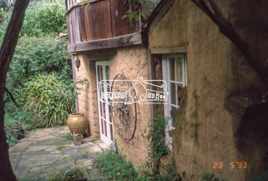
 Eltham District Historical Society Inc
Slide - Photograph, Gordon Ford garden, "Fulling", Pitt Street, Eltham, 23 May 1993
"Fulling", pronounced Fu-elling, the 'display home' of Gordon Ford landscape designer and consultant. From 1945 he transformed one and a half acres of treeless grassland into a splendid bush garden complete with a waterfall and ponds. He used sawdust and wood shavings as a base for the bush floor. The 1993 Eltham Heritage Tour was enjoyed by a busload of members of the Historical Society on a fine, calm day, Sunday May 23rd. Between 10.00 am and 4.30 pm, except for a brief lunch stop at the Eltham Living and Learning Centre, members passed about thirty places of local interest and others recommended for the Historic Buildings Register and the Register of the National Estate. A number of significant trees and buildings were also highlighted along with the opportunity to explored some of the properties.35mm colour positive transparency (1 of 24) Mount - Kodak Kodachromeactivities, shire of eltham historical society, heritage excursion, eltham, fulling, gordon ford garden, pitt street -
 Eltham District Historical Society Inc
Document - Brochure, The Barn at Kinloch Gardens; Elders Real Estate sales material, 1998
Description by Elders Real Estate: A Beautiful Studio Residence: The Barn at Kinloch Gardens Eltham's prestigious Private Country Estate A special part of Eltham's heritage. Beautifully situated on grounds of 1750 square metres with panoramic views, this dramatic building on three levels is converted to a ? office residence from the original farm house of the Kinloch Estate. The main level, 21 metres in length, is a soaring galleried space of 17 squares of flexible living and working areas, extensive storage spaces and private courtyard. Centrally located within Kinloch's landscaped grounds. The Barn is a romantic focal point of a unique enclave of ten contemporary house designed by Graeme Gunn and Ian Jelbart, the cultural mix of old and new confirms the value and reputation of this exclusive private estate. Digital file only; created from scan undertaken by EDHS of item on loanarthur street, elders real estate, eltham, houses, jelbart property, kinloch gardens, real estate agent, the barn, woodridge estate -
 Eltham District Historical Society Inc
Audio Compact Cassette Tape, Shire of Eltham, Audio Recording; Listening to the landscape: stories and places collected from the Shire of Eltham, 1988, 1989
Listening to the landscape is a project in sound, made from recordings and interviews collected in and around the Shire of Eltham over the course of 12 months which were published in 1989. Thirty people, all of whom have lived or worked around the region most of their lives, were interviewed. There are six "channels" of stories: 1. Getting around - 2. "they were the wildflowers - we used to pick armfuls of them in those days" - 3."Up around Kinglake" - 4. "But it was home and no-one could put us out of it" - 5. "It was all orchards" - 6. "gradually the houses came". Each with a slightly different theme. The stories are supported by environmental and historical sound recordings. Tapes converted to three CDs - titled "Getting around" - Armful of flowers" and "Up around Kinglake" which includes the six "channels".Master recordings on three compact cassette audio tapes, TDK AD46. Each tape labeled with the recording track in red ink and Dolby B Noise Reduction activated) also in black ink copyright Duncan King-Smith 1989 Copy 1 Channel 2: Armfuls of Wildflowers Channel 4: “It was home . . .” Copy 2 Channel 1: Getting around Channel 6: “Gradually the houses came . . . ” Copy 3 Channel 3: Up around Kinglake Channel 5: “ . . it was all orchards.” Also commercial compact cassettes and CD formats held and information booklet. Converted to mp3 format from CD 1 - Getting Around; 17:17, 23.7 MB, 192kbs 2 - Gradually the houses came; 17:32, 24.0 MB, 192kbs 3 - Up around Kinglake; 23:31, 32.3 MB, 192kbs 4 - It was all orchards; 23:52, 32.7 MB, 192kbs 5 - Armful of wild flowers; 20:38, 28.3 MB, 192kbs 6 - But it was home, and no-one could put us out of it; 20:58, 28.8 MB, 192kbsaudio cassette, audio recording, duncan king-smith, eltham, listening to the landscape, compact disc, oral history -
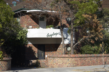 Mission to Seafarers Victoria
Photograph - Digital Image, series, 05/04/2019
Graylings estate was purchased by Frederick Race Godfrey around 1872 on return of a family trip to England. Reverend Gurney Goldsmith met Ethel Godfrey here while he was invited for lunch and rose her interest in the cause of the sailors. The Godfreys organised two picnics for sailors on their property, one in 1905 and one in 1910. The estate was auctioned and subdivided in 1910 after Fredrick's death. But early the same year he had a second house built on the estate. A brick building that may be what is now the Graylings apartments. According to electoral rolls, Ethel Godfrey and her sisters Frederica and Winifred lived at 95 Alma Road. Ferderica Godfrey, one of the earliest female student of Burnley Horticultural College (1899 or1900-1903) is thought to have created the landscaping of the Graylings gardens. Street signs in St Kilda East depicting the area surrounding the former Grayling estate owned by Frederick Race Godfrey until his death in 1910.graylings, frederick race godfrey (1828-1910), ethel augusta godfrey, alma road, st kilda east, burnley horticultural colleg, frederica godfrey, rica godfrey, rita godfrey -
 Kiewa Valley Historical Society
Postcard Circa 1950, Mt. Beauty Village, Kiewa Hydro-Electricity Project, circa 1950
This postcard was produced in the 1950's for the tourist trade in the Kiewa Valley and Alpine region. It encompasses the period when the State of Victoria was pressured by the ever increasing demand by industry and its population for electricity supplies. Hydro electricity was seen as an untapped natural resource to quench this demand. The Victorian Alps and the rivers flowing into its valleys was ideal for the construction of the Kiewa Hydro Electricity Scheme. The late 1940's saw the development of this scheme and the changing of sections of alpine landscape is covered by this and other postcards/pictures (tourists, construction workers, and established rural populations). This period in time was before the established wildlife and forest/nature groups became political activist who changed legislative acts to protect the environment. The regulatory pondage on the northern aspect of the village had no water over-spill from the unfinished power station.This rural region in 1950 (Kiewa Valley/alpine plains) was at most only significant to a smaller group of winter sports, summer hikers/horse riders and rural farmers/graziers. The numbers of tourists and the increase in the local resident population was boosted by the construction of the Hydro Electricity Scheme. This influx to the regional population resulted in a corresponding diversity in services and brought about an environment that responded to a growing level of tourists and thereby permitting this industry to grow more rapidly than it would have naturally. This postcard details an attraction to the "cleaner" method of providing electricity. This postcard was purchased in 1950 by a surveyor at Landford's Gap. The couple shown in this photograph would have been employed by the S.E.C. under the Kiewa Hydro-Electricity Scheme.This item is a scanned black and white photograph of a panoramic view of Mount Beauty Village in 1950 (a closed village, entry by pass only). The regulatory pondage has earthen walls but no water.See 0480 (A) -(D) and (F) for other photos of similar postcards"MT. BEAUTY VILLAGE KIEWA HYDRO-ELECTRIC PROJECT"kiewa valley tourism, victorian alps, alternate energy supplies, alpine population growth -
 Kiewa Valley Historical Society
Photograph of Kiewa Valley Panorama, Farming lands within the Kiewa Valley in1950s, Circa 1950
This photograph shows how (early to mid1900s), before the establishment of the Mount Beauty "gated" village, the Kiewa Valley was farmed and the scarce population was spread out over acres of productive land. This photograph catches a time before (what appeared to the local farmers as the invasion by a mass of construction workers) when this remote valley was part of a "lay back" rural landscape,occasionally visited by friends and some wayward tourists. The mountain ranges provided an adequate barrier against the way-would traveller. The immigration numbers coming into Australia was still quite small ( due to the "white" Australia policy) which was in force before World War II. After World War II a mass of displaced European refugees and migrants boosted the Australian population and provided for a greater degree of diverse professions and rural related work force.This photograph depicts the borderline in time between an exclusively rural based population and respective activities(early 1900s)to the present (2000 on wards) integrated village, tourist and retiree/holiday area. The time when land was exclusively used in agriculture is over and the impact of cheaper rural produce from Asian markets will see a shift of land useage and population activities. The Kiewa Valley is loosing its hiding place and is becoming more and more a source of untapped residential land. Black and white photograph of farming/grazing land useage, before the establishment of the Mount Beauty Village. Small pockets of residentual houses can be viewed. Road access (unsealed dirt) was typical of that provided in rural regions in the 1950s. The photo is on 200gms paper and not on photographic paper.kiewa valley in the early1900s, grazing in the kiewa valley, sec victoria -
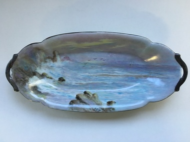 Warrnambool and District Historical Society Inc.
Artefact, China Plate, 1922 (painting)
This plate was painted by J.J. Forrester in 1922. John James Forrester, the son of John Lamb Forrester and Maria Hexter, was an architect in Warrnambool in the early 20th century. He had an office in Kepler Street (1910) and in Koroit Street (1916). He lived in the house in Liebig Street that was formerly the first Savings Bank and was erected in 1860 (7A Liebig Street today). Forrester was a staunch member of the Presbyterian Church and was the co-architect for the re-building of the interior of St. John’s Presbyterian Church in Warrnambool after it was destroyed by fire in 1920. John Forrester was also a noted artist of his time and several of his works of art have survived. A landscape by him is in the possession of the Warrnambool and District Historical Society. This plate is one of two painted by Forrester that survive today.This plate, although damaged, is of interest because it was painted by John James Forrester, a Warrnambool artist from the early 20th century. This is a china plate showing a seascape painted by John James Forrester in 1922. It depicts a coastal scene of rocks, birds and sailing boats. The colours are in mauve/brown/ white tonings and are slightly opalescent. The plate has brown/grey handles with one broken and repaired. The plate is oval-shaped with a slight dip and a stand at the base. Front of plate: ‘J.J.F.’ On base: ‘J.J. Forrester 1922’ john james forrester, history of art in warrnamool, history of architecture in warrnambool, history of warrnambool, china painting