Showing 10618 items
matching sites
-
 Whitehorse Historical Society Inc.
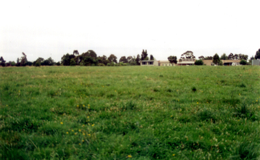
Photograph, Narmara Primary School, 13/01/1994 12:00:00 AM
Coloured photo of Narmara Primary School, looking North from south boundary. School on North side of Highbury Road between Middleborough Road and Blackburn Road. Since demolished and site developed for housing.narmara primary school, warner, philip -
 Whitehorse Historical Society Inc.
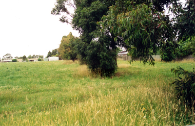
Photograph, Narmara Primary School, 13/01/1994 12:00:00 AM
Coloured photo of Narmara Primary School looking North along East boundary. School on North side of Highbury Road between Middleborough Road and Blackburn Road. Since demolished and site developed for housing.narmara primary school, warner, philip -
 Lakes Entrance Regional Historical Society (operating as Lakes Entrance History Centre & Museum)
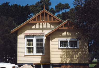
Photograph, LERHS, 1999
Second copy taken 2008 shows changed colour scheme of exterior, decking with handrail added, shrubs established. Situated at rear of Tourist Information Centre, at no. 1 Esplanade.Colour photograph of the Lakes Entrance Historical Society's History Centre, Marine Parade. Photogrpaph shows building on site, soon after removal from Johnsonville school gound in 1999. Lakes Entrance Victoriaworld war 1914-1918, memorials, room display -
 Southern Sherbrooke Historical Society Inc.
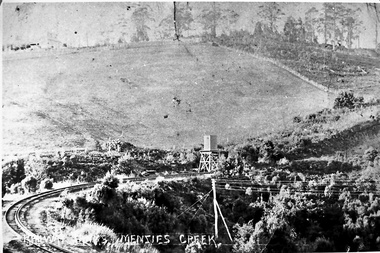
Photograph - Photo-black & white-Puffing Billy track and water tower
Photograph of the railway line to Gembrook and the water tank at Menzies Creek in the centre of the picture. This area, known as The Tanks, is the site of the landslide that closed the railway down in 1953. Glen Park homestead is on top of the hill on the left. -
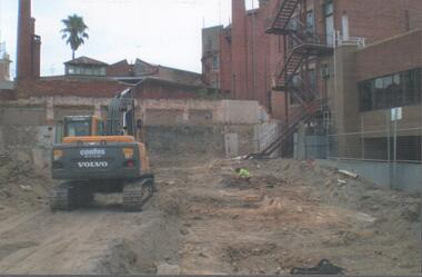 Bendigo Historical Society Inc.
Photograph - Forest Street
Colour photograph showing the demolition work near the corner of Forest and High Street. Red bricks building around the excavation site. An excavator can be seen in the foreground and a man is crouching looking at something on the ground. On the back in pencil Forest street demolition ? 2011forest street, demolition -
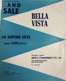 Kew Historical Society Inc
Plan - Subdivision Plan, Bella Vista, Doncaster East
The Bella Vista Subdivision included 101 lots in Murphy Road, Kerry Close, Keir Avenue, Norman Street, Daphne Street in Doncaster East,An undated, four-page colour brochure for the sale of the Bella Vista Estate in Doncaster East. The item includes a separate price list of the home sites maintained by the agent. The latter includes the original and the discounted price. subdivision plans - doncaster east (vic), bella vista subdivision - doncaster east (vic) -
 Canterbury History Group
Ephemera - 152 Mont Albert Road Canterbury, 1998
Real estate advertisement for auction on 23rd May 1998 of "Bukit Tunggal" 152 Mont Albert Road Canterbury(c1963), includes black and white sketch of garden and exterior of the house. floor and site plans.canterbury, mont albert road, hopetoun avenue, bukit tungall, sinclair & co. -
Canterbury History Group
Ephemera - 3 Rubens Grove Canterbury, [1998 or 2009]
Real estate advertisement for the sale by auction of 3 Rubens Grove Canterbury c1928 , on Saturday 10 October {1998 or 2009]. Includes coloured photographs of the exterior of the house and the interior staircase, and floor and site planscanterbury, rubens grove, golden mile, stairs -
Canterbury History Group
Ephemera - "Thornbury" 14 Erica Street Canterbury, 2001 or 2007
Real estate advertisement for the sale by auction of "Thornbury" c1891, 14 Erica Street Canterbury on Saturday 10 March [2001 or 2007] Includes coloured photographs of the Interior and exterior of the house and floor and site planscanterbury, erica street, thornbury, victorian style, swimming pools, maling road -
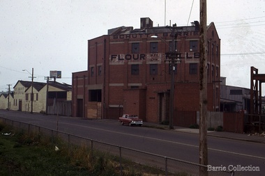 Melton City Libraries
Photograph, Schutt and Barrie Flour Mills, 1969
Arthur Henry Schutt. Born 18th July 1912 at Spotswood He was the third child of John Ralph and Mary Jane Schutt. His grandfather was the first librarian of the Victorian Law Courts and his uncle, William Schutt, was a lawyer who later became the Chief Justice Sir William Schutt. His mother was born a Clutha House, stony Creek Yarraville, a was one of ten children. John Schutt opened a chaff mill at the corner of Williamstown and Geelong Roads at West Footscray. The mill was placed on in an old quarry below the ground which saved much of the backbreaking labour of heaving sheaves of hay up into the machinery, the below ground location enable the hay to be fed directly into the railway trucks into the cutters. An elevator then carried the chaff up from the ground directly into the waiting transport, at a great saving in manpower. The chaff mill became on of the largest in Victoria employing more than forty men, and later moved into flour milling.Schutt and Barrie Flour Mills, Melton South site. Opposite this Mill was a Public Weighbridge. A rail siding crossed Brooklyn road to serve chaff mill. The rail line crossed west of the Methodist Churchlocal identities, agriculture -
 City of Kingston
Pamphlet - Colour, Duffus Bros, Railway Reserve Highett, c. 1923
Sales plan for land in the suburb of Highett, titled Railway Reserve, incorporating properties along Wolseley Street, Livingston Street, Highett Road and Worthing Road. The developing urban area of Highett within the City of Kingston. This land sale pamphlet illustrates the subdivision of land within the municipality and the changing demographic of the district as new houses and shops are constructed close to infrastructure.Colour pamphlet advertising thirty eight shop and villa sites for sale at the Railway Reserve, Highett. Incorporates a map of the reserve with properties available on Wolseley Street, Livingston Street, Highett Road and Worthing Road. Handwritten in grey pencil: assumed sale price recorded on subdivisions 1-7, 10, 22, 23 and 34 Handwritten in grey pencil on subdivision 4: C. Nevill / City of Melbourne bank Handwritten in grey pencil across subdivision 7: 49' Handwritten in grey pencil across subdivision 21 and 22: 134' Handwritten in grey pencil across subdivision 25 and 26: 200' Handwritten in grey pencil across subdivision 36 and 37 and both top and bottom: 120' Hand drawn in blue pencil: outline of subdivision 4 Hand drawn in blue pencil: outline of subdivisions 7, 23, 28, 37, 38 along left hand side, subdivisions 38, 37 and 36 on Wolseley Street, subdivisions 30 and 29 along Wolseley Street, subdivisions 29 and 24 along the middle of the plan, subdivisions 24 and half of 25 along Livingston Street, half of subdivision 20 along the middle of the plan, subdivisions 21 and 22 along the Right of Way between Livingston Street and Highett Road, and along the right hand border of subdivision 7. Handwritten in ink adjacent to the subdivision plan, updside down, in the bottom right hand corner: 276 / 54 / 280 / 45 / 320 / 202 / 200 / 134 / horizontal line / 11/14 Handwritten in ink adjacent to the subdivision plan, updside down, in the bottom right hand corner: 1714)2200(15 / 1714 / horizontal line / 486land sales, highett -
 Whitehorse Historical Society Inc.
Photograph - B/W Photograph, Orchard at Blackburn
Black and white photograph of workers on Pearce family orchard on site of present Blackburn High School. Photo taken by photographer from Herald Sun who came every year to photograph the cherry blossom.pearce, ronald, harry, edward h., blackburn high school, orchard, herald sun -
Canterbury History Group
Ephemera - 16 Balwyn Road, Canterbury, 1/05/2003 12:00:00 AM
Real estate advertisement for the sale by auction on 3 May 2003 of "Shrublands" 16 Balwyn Road Canterbury, with the potential for developement. Includes coloured photographs of the exterior of the mansion and entrance hall, and floor and site plans.canterbury, balwyn road, shrublands, victorian and italianate style -
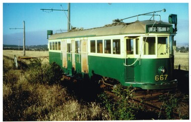 Melbourne Tram Museum
Photograph - Colour Photograph/s, John Phillips DOI, mid 1990's
.1 - Colour print of W3 667 at TMSV site Bylands, mid 1990's. Tram has the destination of "Carnegie - Truganini Rd". Photographed by John Phillips for the Dept. of Transport. Printed on Kodak paper.Each photo has on the rear a "Copyright Department of Infrastructure with details for reordering and a hand written letters "JP"trams, tramways, tmsv, bylands, w3 class, tram 667 -
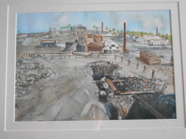 Bendigo Historical Society Inc.
Painting - JOHN HALL COLLECTION: NEW CHUM MINE
BHS CollectionWatercolour by John Hall, in gold timber frame, cream mount board. Painting shows the New Chum Mine site. In foreground, open shaft with timber supports, in background mining chimneys and poppet head.John Hall, Eaglehawkbendigo, mining, new chum mine -
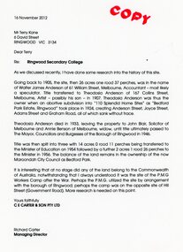 Ringwood and District Historical Society
Document - Folder, Brief history of the Ringwood Secondary College site in Bedford Road, Ringwood, Victoria, since 1905 and subdivision in 1924
Terry Kane and Richard Carter were the authors of the short historyType written notes and plans pertaining to the land titles and history of the Ringwood Secondary College site from 1905, prior to the land being sold by the Borough of Ringwood in 1954 to the Education Department. Transcript of covering letter from Richard Carter to Mr T Kane dated 16 November 2012 - "Re: Ringwood Secondary College As we discussed recently, I have done some research into the history of the site. Going back to 1905, the site, then 26 acres one rood 37 perches, was in the name of Walter James Anderson of 61 William Street, Melbourne, Accountant - most likely a speculator. Title transferred to Theodosia Anderson of 167 Collins Street, Melbourne, Artist - possibly his son - In 1907. Theodosia Anderson was thus the owner when on abortive subdivision Into "110 Splendid Home Sites" as "Bedford Park Estate, Ringwood" took place In 1924, creating Anderson Street, Joyce Street, Adams Street and Graham Road, all of which sank without trace. Theodosia Anderson died In 1933, leaving the property to John Blair, Solicitor of Melbourne and Annie Benson of Melbourne, widow, until title ultimately passed to The Mayor, Councillors and Burgesses of the Borough of Ringwood In 1946. Title was then spilt Into three with 14 acres 0 rood 11 perches being transferred to the Minister of Education on 1954 followed by a further 2 acres 1 rood 26 perches to the Minister In 1956. The balance of the land remains In the ownership of the now Maroondoh City Council as Bedford Park. It Is Interesting that at no stage did any of the land belong to the Commonwealth of Australia, notwithstanding that I always understood It was the site of the P.M.G. Workers Camp after the War. Perhaps the P.M.G. utilized the site by arrangement with the borough of Ringwood; perhaps the camp was on the opposite site of Hill Street (Government Road). More research Is needed on this point. Yours faithfully, CE CARTER & SON PTY LTD Richard Carter Managing Director" -
 Ringwood and District Historical Society
Flyer, Executor's Auction Subdivision Advertisement, Lilydale Road and Oban Road, Ringwood East, Vic. - 1937
Single page advertisement for Executor's Auction of land in Ringwood East on Saturday, May 29, 1937 with locality map showing 26 building sites for auction highlighted in brown, and brief summary of local services available. Subdivision includes Old Lilydale Road, Joseph Street, Dynes Street, Albert Street (later Wyrunga Street), Carcoola Road, and Mount Dandeong Road. (Carcoola Road incorrectly shown as Oban Road on the subdivision plan). Auctioneer - C.E. Carter, (Phone Ringwood 24. -
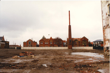 Federation University Historical Collection
Photograph - Photograph - Colour, Remnants of the Ballarat BreweryAfter Building Demolition
Colour photograph showing remains of the Carlton and United Breweries Ballarat site (formerly Ballarat Brewing Company) after demolition. Red brick buildings of the Ballarat School of MInes along Lydiard Street South are featured. ballarat brewery, brew tower, ballarat brewing company, brew, carlton and united breweries, brewery complex, demolition, chimney, paving -
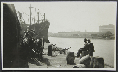 Mission to Seafarers Victoria
Photograph - Photograph, Black and white, Reverend John Reginald Weller, On the Australian Wharf, c. 1925
Black and white photograph with a thin white border depicting the Australian wharf: two horses, steam ship, two men one siting on a barrel. Across the Yarra river: docks and in the background, the Robur Tea House.Stamps: In purple ink: Herschell's Print, Pathe Agents / in blue ink: "384" Handwritten in black ink and in pencil: "6" australian-wharf, yarra-river, robur tea house, weller album -
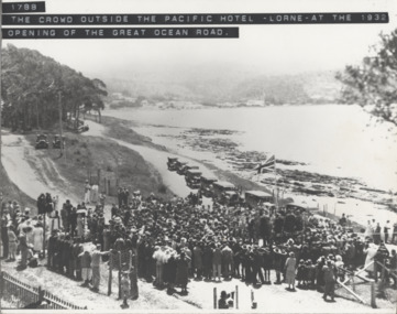 Lorne Historical Society
Photograph, Offical Opening Celebrations at Pacific Hotel Lorne 26th November 1932
The Great Ocean Road was officially declared open on 26th November 1932 at a ceremony near Lorne's Grand Pacific Hotel, the site where the first survey peg for the road was hammered into the ground 14 years before. opening ceremony: lorne pacific hotel: 26/11/1932 -
Glenelg Shire Council Cultural Collection
Pamphlet - Brochure - Glenelg River Canoeing Guide, Oct-88
Glenelg River canoeing guide, 4 pages, single-fold. Front and back pages information, photos and images of various areas of the Glenelg River; inside pages - detailed map of river and landings/camp sites. -
Glenelg Shire Council Cultural Collection
Photograph - Photograph - Silo Construction, 1964
Port of Portland Authority ArchivesBack: Blue Portland Harbour Trust Stamp 195. 18-12-64 in black ink.port of portland archives, silo construction -
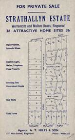 Ringwood and District Historical Society
Flyer, Land Sale Advertisement - Strathallyn Estate, Ringwood, Victoria - circa 1950
Advertisement for private sale of 36 home sites in the Warrandyte Road and Mullum Mullum Road area of Ringwood, with map showing layout of subdivision and summary of local features and services. Handwritten notation indicates May, 1950.Subdivision includes Warrandyte Road, Strathallyn Road, Norman Court, Lade Court, and Mullum Mullum Road. Agents: A.T. Miles & Son, 175 Main Street, Ringwood, Phone WU6215. -
Glenelg Shire Council Cultural Collection
Photograph, Port of Portland Authority, n.d
Port of Portland Authority ArchivesFront: Blue biro line across top of photo.port of portland archives, portland harbour, s l patterson wharf -
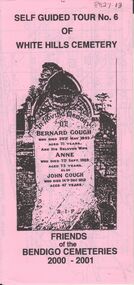 Bendigo Historical Society Inc.
Document - BENDIGO CEMETERIES COLLECTION: SELF GUIDED TOUR NO. 6 DOCUMENT
Pink coloured trifold document: Self guided tour No. 6 of White Hills Cemetery. Friends of the Bendigo Cemeteries 2000 - 2001. Photo of headstone of Bernard Gough on front. 31 numbered grave sites with descriptions.Friends of Bendigo Cemeteries 2000bendigo, cemetery, white hills cemetery tour -
 Bendigo Historical Society Inc.
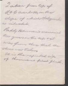
Document - KELLY AND ALLSOP COLLECTION: NOTE ABOUT A PHOTO
Handwritten note in pencil: 'Taken from top of Mt. Charlotte, in the slope of which Kalgoorlie is situated. Paddy Hannan's memorial tree grows on the top -? - was from there that the stone was taken. It is the reputed site of Hannan's first find.'business, stockbroker, kelly & alsop, kelly & alsop collection - note about a photo, paddy hannan -
Bendigo Historical Society Inc.
Book - A HISTORY OF THE SAINT KILIAN'S CHURCHES, BENDIGO FROM 1852 TO THE PRESENT, 1998
A History of the Saint Kilian's Churches Bendigo, from 1852 to the present. Includes, churches on the St. Kilian's site, slab and canvas church, the pro- cathedral, weatherboard church. 6 pages with colour illustrations, maps. With Indexchurch, history, st. kilian's catholic church, bendi, st. kilian's, history of church, church, renovation of church. -
 Bendigo Historical Society Inc.
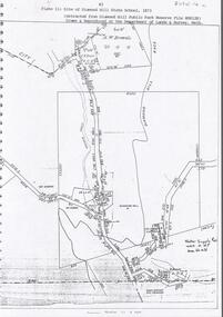
Document - DIAMOND HILL STATE SCHOOL SITE
Map (copy) showing the site of Diamond Hill State School, 1873. On top of page 'extracted from Diamond Hill Public Park Reserve File RS8128, drawn and reproduced at the Department of Lands and Survey, Melbourne'bendigo, education, diamond hill state school -
 Bendigo Historical Society Inc.
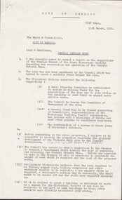
Document - CENTRAL DEBORAH GOLD MINE - LETTER
Typed copy of a letter from A. J. Watts, Town Clerk to The Mayor & Councillors, City of Bendigo regarding a museum and tourism at the Central Deborah Mine. Also mentioned are the Nell Gwynne Mine and the Victoria Hill site.mine, gold, central deborah gold mine, central deborah gold mine, a. j. watts, nell gwynne mine, victoria hill mine, cr. a. l. roy, the historical society -
 Bendigo Historical Society Inc.
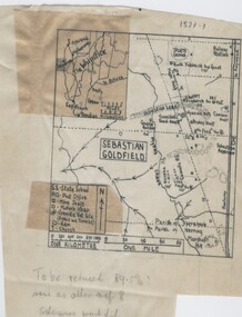
Negative - TOM PATULLO COLLECTION: SEBASTIAN GOLDFIELD
Negative,/Hand drawn of the goldfield featuring gold mine sites,cyanide vats,heaps,railway station,sports ground. A small map of the Whipstick area, and legend. Tom Patullo was formerly of Clear-Ads Bendigo.cottage, miners, sebastian goldfield, sebastian goldfield