Showing 4552 items matching "historical map"
-
 Bendigo Historical Society Inc.
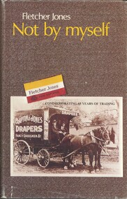
Book - FLETCHER JONES NOT BY MYSELF, c1984
Not By Myself. Publisher: Kingfisher Books pty Ltd ISBN: 0 959 3999 8 4. Place of publication: Cheltenham. (b) 1976 (a) 1984. Third Edition. 240 Pages Copy (a) has black and white photo of Fletcher Jones, copy (b) has color photo of Fletcher Jones. Clothing Manufacturer. Illustrations: photographs, Illustrations, maps, extracts from newspapers, copy of Hawkers Licence. Markings: Bendigo Historical Society Stamps inside front and back of book. Copy (b) has been removed from grey cabinet 3 and placed in book overflow box.Fletcher Jonesbook, fletcher jones, fletcher jones, clothing manufacturer, hawker, victoria -
 Bendigo Historical Society Inc.
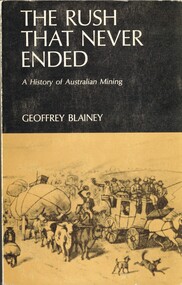
Book - THE RUSH THAT NEVER ENDED, c1969
The Rush That Never Ended A History of Australian Mining. Publisher: Melbourne University Press, Carlton. Edition: 2nd. Photographs, Illustrations and Maps. Cost $2.85 Markings/Inscriptions: Bendigo Historiacal Society. Harold Currnow 19-8-69. SBN: 522 83930 4. Notations on pae 35, 2 lines underlined.Geoffrey Blaineyaustralia, gold mining, australian gold mining -
 Bendigo Historical Society Inc.
Book - BENDIGO TOUR GUIDE OF HISTORIC BUILDINGS, c1982
Bendigo Tour Guide of Historic Buildings. Publisher National Trust of Australia. ISBN: 0 909710 34 1. Publisher; National Trust of Australia (Vic.). Photographs, illustrations and maps. 86 pages. Sticker on spine and BHS, Bendigo Premier Town Victoria 1982-1985 and stamp on page 1.G Flanders & M Butcherbook, bendigo, buildings, historic, national trust of australia -
Bendigo Historical Society Inc.
Book - BENDIGO THE GOLDEN AGE RETRACED, 1973
Bendigo the golden age retraced Front cover is a map of the area using white lines to point out points of interest in Bendigo. These places are then described in brief detail throught the book. There are also illustrations of each place of interest. Part A has a signature inside the front cover dated 1973. b, has a photo of 'Sun Loong' in front of the Shamrock Hotel, at easter time. This is in a plastic folder which is then inside a folded card, with adrawing of the old Town Hall on the front. C, has a library sticker on the lower spine, numbered 0035 nei. With Index. 64 pages.Jan Neilbendigo, buildings, effects of gold in bendigo., . -
 Bendigo Historical Society Inc.
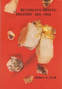
Book - BENDIGO'S MINING HISTORY 1851 - 1954, 1991
Bendigo's Mining History 1851 - 1954. Introduction and overview of gold and mining by the pioneers in the Bendigo area. Contains photographs, Illustrations and Maps. Page 1 has a letter of thanks from James Lerk to the Bendigo Historical Society for use of material in their collection. Autographed by author on 22 July 1991James A. Lerkhistory, mining -
 Bendigo Historical Society Inc.
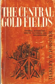
Book - THE CENTRAL GOLD FIELDS, c1969
... and maps. Inscriptions: $1.20, Bendigo Historical Society... and maps. Inscriptions: $1.20, Bendigo Historical Society ...The Central Goldfields, Historical Backgrounds Bendigo, Castlemaine and neighbourhood. Publisher Cypress Books, printed by Cambridge Press, Melbourne. 80 pages. Photographs, illustrations and maps. Inscriptions: $1.20, Bendigo Historical Society. With IndexHarley W Forsterhistory, mining, central goldfields, harley w forster -
 Bendigo Historical Society Inc.
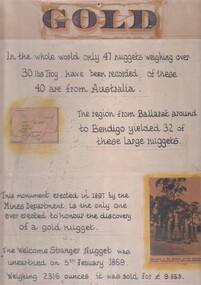
Document - 'GOLD' POSTER WITH DESCRIPTION OF NUGGETS
Poster heading - 'Gold' - 'In the whole world, only 47 nuggets weighing over 30lbs Troy have been recorded. Of these 40 are from Australia. The region from Ballarat around to Bendigo yielded 32 of these large nuggets. This monument erected in 1897 by the Mines Department, is the only one ever erected to honour the discovery of a gold nugget. The 'Welcome Stranger' nugget was unearthed on 5th February, 1869, weighing 2316 ounces and it was sold for 9.553 pounds'. Poster includes a map of Victoria depicting the main gold mining areas, also mention of gypsum, and tin in northern Victoria. A photo of the monument to the discovery of the 'Welcome Stranger' nugget found 1 1/4 miles from Moliagul in the bottom corner.document, gold -
 Bendigo Historical Society Inc.
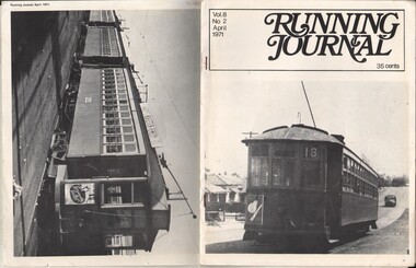
Document - BASIL MILLER COLLECTION: TRAMS - 'RUNNING JOURNAL', April 1971
Journal of the Tramway Museum Society of Victoria Ltd. Volume 8, No. 2, April 1971, 35 cents. Sixteen pages. Cover photo (right) show D class no. 99 sits at the side of the road at Inglewood. On back cover (left), show A class no. 121 sitting in front on an E car and D car at the siding in 1958. Article in this journal wrote about electric trams transport in Perth, include planning routes map. History of object: Part of 'Basil Miller Tramways Collection'cottage, miners -
 Bendigo Historical Society Inc.
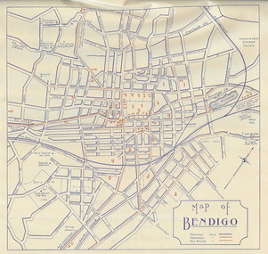
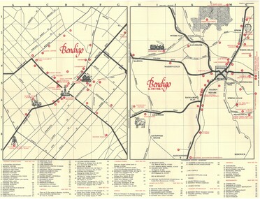
Document - BASIL MILLER COLLECTION: BENDIGO MAP, September 1956
Map of Bendigo with places of interest. Issued by Victorian Railways Public Relations and Betterment Board.person, individual, baby portrait -
 Bendigo Historical Society Inc.
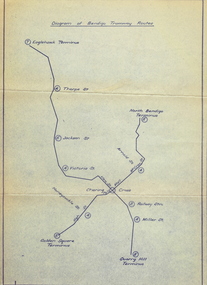
Document - BASIL MILLER COLLECTION: MAP: BENDIGO TRAMWAY ROUTES
Diagram of Bendigo Tramway Routes. Showing Eaglehawk terminus through to Quarry Hill Terminus and North Bendigo Terminus to Golden Square Terminus. Printed on pale bluish paper with dark blue print.person, individual, baby portrait -
 Bendigo Historical Society Inc.
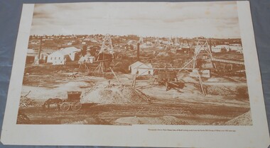
Photograph - Photograph of New Chum Line of Reef
BHS CollectionSepia coloured print of a photograph of the New Chum Line of Reef looking south from the Snobs Hill group of mines. The photo shows several poppet heads and chimneys, bridges and houses. New Chum Line of Reef. includes Victoria Hill possibly the richest spot on the field.On the back a drawing of a poppet head with the words: Bendigo gold project. A small map of Victoria is also printed on the back. bendigo mines, new chum line of reef, mining -
Bendigo Historical Society Inc.
Document - Bendigo Tramways Brochure, abt 1950s
In 1890 Bendigo's first tramway battery-electric carriages operated between Sanhurst and Eaglehawk. In 1892 Battery-electrics were replaced by steam tram cars on the Bendigo Railway Station track to Eaglehawk. In 1903 Electric traction overhead was inaugurated extending to Quarry Hill, Golden Square and Lake Weeroona. In 1913 Open cross-seat cars added for the service Quarry Hill to Eaglehawk. In 1945 Traction bogie cars replaced older cars. In 1947 Birney safety cars (dead man controllers) replaced older carsBrochure, a "Welcome to Bendigo, and "Evolution of Bendigo Tramways." 8668.1 Brochure is titled "Welcome to Bendigo," on the front a photo of Charing Cross and Trams, also the Bendigo City Coat of Arms. Inside two pages and descriptions of six tram showing the "Evolution of Bendigo tramways." On the rear is a map of the tramways and places of interest to visit. The brochure was "Printed for the preservation committee in co-operation with the Royal Historical Society of Victoria (Bendigo and District Branch) All donations for a preservation fund."history, bendigo tramways, evolution of bendigo tramways -
Bendigo Historical Society Inc.
Book - A LEGACY FROM THE PAST.. A LINK WITH THE FUTURE - AN OPEN SPACE STRATEGY FOR BENDIGO, 1988
32 page soft cover booklet 'A Legacy from the Past… a Link with the Future. An Open Space Strategy for Bendigo' Prepared for the Bendigo Sub-Regional Committee of the Loddon-Campaspe Regional Planning Authority, February 1988. Illustrated with maps, B&W photos and sketches. Main chapters 1. Open Space and Bendigo 2. An Open Space System - water courses and Bendigo Creek 3. The Provision of Public Open Space 4. Study Conclusions and Proposals.Evan Jones -
Bendigo Historical Society Inc.
Book - A FINE SHEET OF WATER - HISTORY OF KENNINGTON RESERVOIR BENDIGO, 2012
174 page soft cover book 'A Fine Sheet of Water, History of Kennington Reservoir, Bendigo'. By Bill and Carol Holsworth with the help of the Friends of the Kennington Reservoir and members of the Bendigo Field Naturalists Club. Published by the Bendigo Field Naturalists Club 2012 . Illustrated with B&W photos, maps and sketches. Colour arial photo of the Reservoir on front cover. Descriptions of early development plus flora and fauna.Bill and Carol Holsworth -
 Bendigo Historical Society Inc.
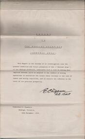
Document - REPORT ON THE BENDIGO GOLDFIELD, EDWARD DYASON
Grey cover document, 21 typed pages with map of goldfield appended. On front page 'Report on the Bendigo Goldfield Central Area. This report is the outcome of an investigation into the present condition and future prospects of the Central Area of the Bendigo goldfield, undertaken with a view to seeing what improved methods could be adopted in the conduct of mining operations to neutralise the recent heavy increase in the cost of labour and mining requisites, and so restore the industry to the level of its previous prosperity' Signed by E.C. Dyason, B.Sc. B.M.E., Commonwealth Chambers, Bendigo, Victoria, 15th November, 1918.bendigo, gold mining, report on goldfield, bendigo goldfield, goldmining, mining companies, reef lines, underground workings, e.c. dyason -
 Bendigo Historical Society Inc.
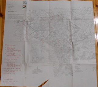
Map - BENDIGO HISTORICAL SOCIETY COLLECTION: EAGLEHAWK MINE MAP
... mountings, battery mountings? Map BENDIGO HISTORICAL SOCIETY ...Base map Australian map grid of Eaglehawk area. Map has letter attached from the Department of Conservation, Forests and Lands, 22 March, 1990, addressed to Felicity Kingerlie, BHS, requesting information regarding the historic mining sites marked on the map. Sites marked are: A. Golden Age Mine, engine mountings present B. Johnson's No. 2 Mine, engine mountings, old boiler foundations C. Johnson's No. 1 Mine, mullock retaining wall made from sandstone, engine mountings, remains of old building demolished? D. Toma's Eucalyptus Factory, old boiler still there, boiler shed, chimney (remnants of) outlet drain, distilling vats, dam, remnant of winch. E. New Argus Mine,mullock heap F. New Moon Mines Dams (1) stone walls G. North Lightning Hill Mine, engine mountings, quartz retainer wall, Pascoe and Simmons open cuts and other open cuts here too H. New Prince of Wales Mine and Poppet Head I. Quarry site for stone, excavation (for miners cottages in Clarke Street) J. Lancashire open cut mine K. Virginia Hill (cynaide vats etc) L. South Prince of Wales mine, now capped and fenced M (possibly ) Catherine United Mine, engine mountings, battery mountings?bendigo, mining, eaglehawk mines -
 Bendigo Historical Society Inc.
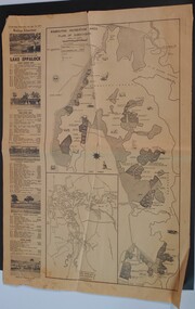
Newspaper - WES HARRY COLLECTION: BENDIGO ADVERTISER NEWSPAPER SAT. 10 AUGUST 1971 ON OPENING LAKE EPPALOCK
Bendigo Advertiser full page article Saturday 10th August 1971 on the opening of Lake Eppalock showing maps of the Lake and attractionsbendigo Advertiser -
 Bendigo Historical Society Inc.
Document - TED BEATIE COLLECTION: MAP, Pre 1980s
Bendigo tourist map and information guide - printed by the Bendigo and District tourist Association -
 Bendigo Historical Society Inc.
Document - DEBORAH REEF PROJECT ENVIRONMENT EFFECTS STATEMENT
Two page document. On top, first page ' Bendigo Mining N.L., Deborah Reef Project, Environment Effects Statement, Summary Brochure'. Poppet head on top LH corner of document. A map of central Bendigo is drawn on page 1 and shows the location of the proposed processing plant near the Airport. Further maps on page 2 and 3 show the North Deborah Mine Site, the pipeline route and the airfield site. The summary brochure provides an outline of the material contained in the Environment Effects Statement and proposed planning scheme amendments upon which, the Deborah Reef Project will be assessed. Page four lists the issues that impact on this submission: planning and land use; socio economic environment; traffic; discharges to air; water management; explosives storage and handling; subsidence; heritage; flora and fauna and landscape and visual assessment. The 16th March, 1989, is the date given for submissions to be lodged in regard to this project.Bendigo Mining N.Lbendigo, mining, deborah reef project -
Bendigo Historical Society Inc.
Book - THE CATHOLIC CEMETERY AT AXEDALE
34 page spiral bound booklet entitled The Catholic Cemetery at Axedale. 150+ years of operation.. Research and text by Mal Nolan. Published 2020 Includes a list of names death date, age etc of all burials. A map of the cemetery and 6 colour photos including the front cover pageMal Nolan -
Bendigo Historical Society Inc.
Book - BENDIGO SUB-REGIONAL STRATEGY PLAN 1980
141 page soft cover spiral bound booklet 'Bendigo Sub-Regional Strategy Plan - September 1980' Areas covered , City of Bendigo, Borough of Eaglehawk, Shires of Huntly, Marong and Strathfieldsaye. Maps included.Bendigo Sub-Regional Committee -
 Bendigo Historical Society Inc.
Document - AULSEBROOK COLLECTION: HISTORY OF AYERS ROCK BOOKLET, 1968-1970
The Significance if Ayers Rock for Aboriginies A5 Booklet, black and white, gloss paper 20 pages Extensive information on the local Aboriginal history in Ayers Rock Various images of Ayers Rock and maps -
Bendigo Historical Society Inc.
Document - CERTIFICATE OF TITLE MCKENZIE STREET
Certificate of title under the transfer of land act 1890. Vol.3219 fol.643627. James Dunlop Boyd medical practitioner and Annie Sophia Boyd married woman, both of McKenzie Street Bendigo areas tenants in common the proprietors of an estate in fee simple, subject to the encumbrances notified hereunder in all this piece of land delineated and colored red on the map in the margin being part of crown allotment fourteen section two B city of Bendigo, together with a right of carriageway over the road colored brown on the said map. Dated the fourteenth day of August 1907.buildings, commercial, mckenzie street -
Bendigo Historical Society Inc.
Book - REPORT ON THE NORTH CENTRAL STUDY AREA OF VICTORIA
252 page Report on the North Central Study Area by the Land Conservation Council of Victoria - July 1978 Illustrated with B&W photos Back section contains several removeable maps. Printed by F D Atkinson, Government Printer, MelbourneLand Conservation Council, Victoria -
Bendigo Historical Society Inc.
Map - DEVONSHIRE GROUP OF MINES
Small map of Devonshire group of mines, Bendigo. Scale 8 chains to 1 Inch. Issued by M. P. Kelly sharebroker, Bendigo. Showing Hercules and Energetic, Pearl, New Victoria Catherine,, New St Mungo, xtended south devonshire, South Devonshire, United Devonshire,duchess of Edinburgh, Phoenix, South st Mungo, Lady Barkly, St. Mungo, Sadowa, Ellenborough, Williams' United, Catherine Reef United.bendigo, mining, devonshire mine -
Bendigo Historical Society Inc.
Map - PLAN SHEEPWASH CREEK
Two laminated maps, one in colour the other black and white, showing German Gully, sheepwash creek, milkmaid flat. -
Bendigo Historical Society Inc.
Map - PLAN NEW CHUM LINE OF REEF
Plan showing outcrops of reefs on supposed extension south of the New Chum line of reef from the Eureka extended company's ground. Scale 8 chains to 1 inchplan, bendigo, new chum line of reef -
Bendigo Historical Society Inc.
Map - PLAN SHOWING SURFACE EXTENSIONS OF QUARTZ REEFS
Plan shewing surface extensions of quartz reefs northward from Eaglehawk, Sandhurst. -
Bendigo Historical Society Inc.
Map - GEOLOGICAL MAP BENDIGO GOLD FIELD
Geological map Bendigo gold field. Showing anticlines, synclines, shafts, alluvial, contours. Produced by the deprtment of mines. Two originals plus two laminated copies -
 Bendigo Historical Society Inc.
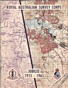
Document - AULSEBROOK COLLECTION: ROYAL AUSTRALIAN SURVEY CORPS JUBILEE 1965, 1965
Aulsebrook Collection: two pamphlets relating to a Jubilee events at the Royal Australian Survey Corps. Title: Royal Australian Survey Corps, Jubilee 1915-1965 (x 2 pamphlets) Two pamphlets for same event, A5, colourful map on the front of the booklet, -First pamphlet is a dinner and wine menu for Jubilee event -Second pamphlet is a information booklet on a brief history of the Corps, and a list of ranks and individuals in the Survey Corps. Booklet also has some photos of Fortuna where the Corps is.