Showing 11321 items matching "land-clearing"
-
 Bendigo Historical Society Inc.
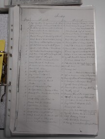
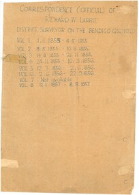
Document - RICHARD LARRITT COLLECTION: LETTERS, 1850s
Folder of Richard W. Larritt's letters/notes regarding the surveying of land in the Bendigo (Sandhurst) region.Richard Larrittperson, government, richard w. larritt -
 Bendigo Historical Society Inc.
Document - RICHARD LARRITT COLLECTION: LETTERS, 1850s
Folder of Richard W. Larritt's letters/notes regarding the surveying of land in the Bendigo (Sandhurst) region. Richard Larrittperson, government, richard w. larritt -
 Canterbury History Group
Letter - Request to purchase land from the Victorian Railways, 1937 - 1939
Collection of letters and drawings between A.D.Jackson and the Victorian Railways, relating to the purchase of land 1937 - 1939canterbury, canterbury road, canterbury station, victorian railways, jackson> a.d., pharmacies, car parks -
Lakes Entrance Historical Society
Book, Hannan, Kirsty, St Johns Church, Metung, Victoria, 2005
Research, interpretation land management recommendations for St. John's Church, Metung, Victoria, by Forestec Studentreligion, land settlement -
 Wangaratta RSL Sub Branch
Print - Framed print
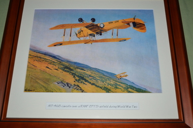
During World War II, the RAAF established twelve Elementary Flying Training Schools (EFTS) to meet the rapid demand for pilots in an expanding Air Force.Due to a shortage of pilots, observers, wireless operators and gunners, the Dominions of the Commonwealth agreed to establish a co-ordinate scheme to train 28,000 air crew each year to help England fight the war in Europe. It was known as the Empire Air Training Scheme (EATS). The Dominions would supply the trained aircrew and the mother country would provide the aircraft. Brown timber frame with cream mount containing print of two planes flying over landA17-468 cavorts over a RAAF EFTS airfield during World War Twoa17-468, raaf, ww2 -
 Lakes Entrance Historical Society
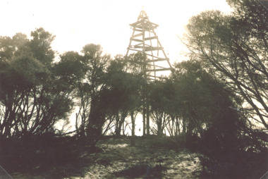
Photograph - Timber Beacon Gippsland Lakes, Vacinity of Raymond Island Victoria, 1900 c
On back of original Raymond Island Tambo River in distance. This survey lookout has been washed away, seawater has killed vegetation and allowed erosionBlack and white photograph of a timber beacon on land in Gippsland Lakes in vacinity of Raymond Island Victoriaboats and boating, navigation, waterways -
 Bendigo Historical Society Inc.
Document - RICHARD LARRITT COLLECTION: LETTERS, 1850s
Folder of Richard W. Larritt's letters/notes regarding the surveying of land in the Bendigo (Sandhurst) region.Richard Larrittperson, government, richard w. larritt -
Tatura Irrigation & Wartime Camps Museum
Work bench, 1943
Made and used at Camp 13. Purchased 1948 at the camp clearing sale by Dave Campbell. Passed on to W. Finlay in 1980. Given to this museum by him in 2010.Workshop bench (timber)tatura, camp 13, murchison, ww2, handcrafts, woodwork -
 Kew Historical Society Inc
Plan - Subdivision Plan, Old Kew Golf Links Estate - Third Section, 1920-1929
Pru Sanderson, in her groundbreaking ‘City of Kew Urban Conservation Study : Volume 2 - Development History’ (1988), summarised the periods of urban development and subdivisions of land in Kew. The periods that she identified included 1845-1880, 1880-1893, 1893-1921, 1921-1933, 1933-1943, and Post-War Development. These periods were selected as they represented periods of rapid growth or decline in urban development. An obvious starting point for Sanderson’s groupings involved population growth and the associated economic cycles. These cycles also highlighted urban expansion onto land that was predominantly rural, although in other cases it represented the decline and breakup of large estates. A number of the plans in the Kew Historical Society’s collection can also be found in other collections, such as those of the State Library of Victoria and the Boroondara Library Service. A number are however unique to the collection.The Kew Historical Society collection includes almost 100 subdivision plans pertaining to suburbs of the City of Melbourne. Most of these are of Kew, Kew East or Studley Park, although a smaller number are plans of Camberwell, Deepdene, Balwyn and Hawthorn. It is believed that the majority of the plans were gifted to the Society by persons connected with the real estate firm - J. R. Mathers and McMillan, 136 Cotham Road, Kew. The Plans in the collection are rarely in pristine form, being working plans on which the agent would write notes and record lots sold and the prices of these. The subdivision plans are historically significant examples of the growth of urban Melbourne from the beginning of the 20th Century up until the 1980s. A number of the plans are double-sided and often include a photograph on the reverse. A number of the latter are by noted photographers such as J.E. Barnes.When the old Kew Golf Links was subdivided in the mid 1920s, the developers were able to break the sale into sections. The third section included eighty lots. The lots faced Kilby Road, Kodak Avenue, Belford Road, Baker Avenue, Mathers Avenue, and White Avenue. [Kodak Avenue was renamed Page Avenue at a later date].The ‘Kew Conservation Study (1988) notes that ‘On the subdivision plan, Kodak’s involvement is commemorated by the naming of the streets after Company directors, and their decision to not proceed with the construction of the factory is explained as a response to the increase in the value of the land. This explanation may have been Estate Agent’s hyperbole, as the Kodak Company records suggest that the land, with its wide creek gully, was unsuitable and too small for its purposes.subdivision plans - kew, old kew golf links estate - third section -
 Bendigo Historical Society Inc.
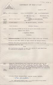
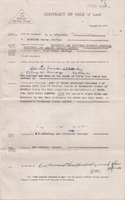
Document - H. A. & S. R. WILKINSON COLLECTION: CONTRACT OF SALE
Contract of sale of land dated 14th may, 1956 between Mr. H Nolan (vendor) and Mrs. L. J. Smith (purchaser). Property: land situate 55 Myrtle Street, Bendigo land described in Right to Occupy residence area no. 125 - Also land described in Permissive Occupancy No. W70141, together with weatherboard and rough cast dwelling and all sundry outbuildings, also blinds, curtains, electric light fittings and shades, electric sink heater, electric stovette in kitchen, galvanised iron tank and all floor coverings with the exception of the lino in the middle bedroom. Price: 3,400 pounds.organization, business, h.a. & s.r wilkinson real estate -
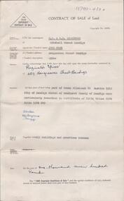
 Bendigo Historical Society Inc.
Document - H. A. & S. R. WILKINSON COLLECTION: CONTRACT OF SALE
Contract of sale of land dated 5th September, 1946 between Sandhurst & Northern District Trustees Executors & Agency (vendor) and Mr. E. J. Schodderlein (purchaser). Property: the surface and down to the depth of 50 feet below the surface of land being part of Crown allotment 41A section 127C, Parish of Sandhurst City of Bendigo, land described in certificate of title volume 5114 folio 122735. Also the vendor's right title and interest in the land adjoining held under occupancy No. H46884, together with all buildings and erections thereon. Subject to the existing tenancy. Price: 1,375 pounds.organization, business, h.a. & s.r wilkinson real estate -
 Mt Dandenong & District Historical Society Inc.
Photograph, Worker's Hut
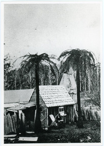
Copy of a photograph depicting a man sitting on a chair reading outside a worker's hut at Mt Dandenong. The hut is small and crudely made from tree slabs. Two tall tree ferns are at the front. The trees at the rear of the picture are possibly ringbarked in preparation for clearing. Early 1900shut, worker's hut, tree ferns, slab hut, mt dandenong, mount dandenong -
 Lakes Entrance Historical Society
Postcard - The Entrance, 1940
Hand tinted small format postcard of the man-made entrance from Bass Strait to the Gippsland Lakes taken from Jemmys Point. It also shows the rock groynes at the entrance to Cunninghame Arm, and the grassy clearing atop Jemmys Point in the foreground. Lakes Entrance Victoriaislands, topography, waterways -
 Whitehorse Historical Society Inc.
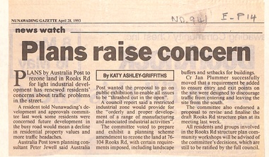
Newspaper - Article, Plans raise concern, 28/04/1993
Article in Nunawading Gazette. Plans by Australia Post to rezone land in Rooks Road to light industrial development concern residents about traffic problems. Council voted to prepare and exhibit planning scheme amendment to rezone land at 76 - 104 Rooks Road.post offices, australia post, rooks road, mitcham, no 76 - 104, jewell, peter -
University of Melbourne, Burnley Campus Archives
Booklet, The University of Melbourne, Dean's Honours and Awards Presentation, 2002-2009
dean's awards, awards, the university of melbourne, institute of land and food resources, school of land and environment -
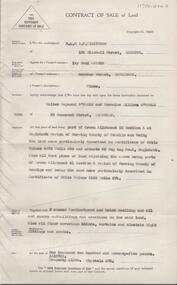
 Bendigo Historical Society Inc.
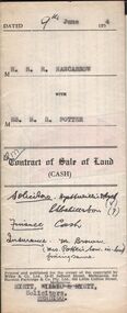
Document - H.A. & S.R. WILKINSON COLLECTION: CONDITION OF SALE
Contract of sale of land (cash) dated 9th June, 1954 between Mr. R.R. Nancarrow (seller) and Mrs M.R. Potter (buyer) for land above 50 feet below the surface and all that piece of land being part of allotment section K Parish of Sandhurst, City and County of Bendigo described in the plan at the end hereof and thereon coloured red with a frontage to Atkins Street, Bendigo. Price 1,700 pounds.organization, business, h.a. & s.r wilkinson real estate -
 Bendigo Historical Society Inc.
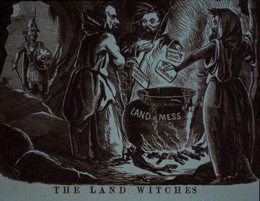
Slide - DIGGERS & MINING. LIFE OF THE SELECTORS, c1860
Diggers & Mining. Life Of The Selectors. Diggers & Mining. A soldier looks on as three male witches stand around a cauldron placing cards in the pot with OCCUPATION LICENSES, LEASE HOLDS and AGRICULTURAL AREAS written on them, the cauldron is labelled LAND MESS. The title of the picture is 'The Land Witches'. Markings; Life Of The Selectors 1860-1890 Set 432 No. 16. The Land Witches ''Melbourne Punch,'' Feb 25, 1864. Used as a teaching aid.Visual Eduation Centreeducation, tertiary, goldfields -
 Bendigo Historical Society Inc.
Document - H. A. & S. R. WILKINSON COLLECTION: CONTRACT OF SALE
Contract of sale of land dated 13th December, 1950 between Mrs. J. Cosh (vendor) and Mr. R. Spicer (purchaser). Property: land being part of Crown allotment 3A section 161C, Parish of Sandhurst City of Bendigo, land described in certificate of title volume 8174 folio 1034639, together with all buildings and erections thereon. Price: 1,700 pounds. Attached 2 hand written notes.organization, business, h.a. & s.r wilkinson real estate -
 Federation University Historical Collection
Plan, Burrumbeep, 1884, 16/10/1884
Auctions of Crown land were introduced in the Colony of Victoria from 1851 to encourage settlers to occupy and work the land. Many squatters purchased land at auction at the upset (minimum) price of £1 per acre. In some areas where demand was high, such as the goldfields, the price realised at auction was much more. Land was put up for sale in the study area on the Burrumbeep run in May 1855, on the Lexington run in 1857, and on the Gorrinn run in 1858. (http://www.ararat.vic.gov.au/library/document/thermatics.pdf, accessed 27 January 2015) For 70 years or more, Yalla-y-Poora, Burrumbeep, Edgarley, Mount William and Narrapumelap ranked in the leading wool producers in Victoria. 1 Stud owners at Yalla-y-Poora, Eurambeen, Burrumbeep and Challicum crossed merino sheep with sheep descended from John Macarthur's Camden Park in New South Wales. (http://www.ararat.vic.gov.au/library/document/thermatics.pdf, accessed 27 January 2015) In what was to become the Ararat Mining Division, gold was discovered in May 1854 on the Burrumbeep run at a place that became known as Pinky Point on the Mount William goldfield. By 21 June 1854, between 600 and 1,000 people had arrived. (http://www.ararat.vic.gov.au/library/document/thermatics.pdf, accessed 27 January 2015)\ Town allotment plan for Burrumbeep. Merrymbuela, Borung, Lexington and Langi Logan are neighbouring areas. The plan includes the Burrumbeep Pre-Emptive Right (Roger and Wright); licensed land holders including Stephen Young, John Carroll, William Walsh, Thomas Purcell, Martha M. Bond, Colin Johnson, John Charles Webb, Henry Withycombe, William Henry Barbridge, John Wall, Thomas Flatelly, William Jenkinson, Elisia Radford, V. Radford, Denis Byrne, George Cook. Land holders included Andrew Maloney, Richard Wingfield Harrocks, W. Sporton, Terence Lynch, F. S. Falkiner, A. Millman, H. Morris, George Upham, J. McCLure, S. Fletcher, W. Parker, Thomas Myers, William wright, W.C. Winter, C. Wordman, Oliver A. Winter This plan is associated with former Ballarat School of Mines student Richard Squire (1875-6) Gift of the Squire FamilyVerso written in pencil - Plan of Burrembeep Ararat Burrembeep Araratburrumbeep, corrinn, langi logan, merrymbuela, lexington, ararat, roger & wright, cook, rogers, upham, george upham, ross, parsans, morris, johnson, withycoombe, colin johnson, falkiner, dsporton, john carroll, donald gordon, denis bryne, maurice dooley, martha bond, william harricks, \william wingfield harricks, william l.c. harricks, michael houlihan, thomas purcell, martin ryan, michael cody, fletcher, mccaw, w. parker, j.m. clow, elisia radford, thomas radford, thomas myers, barbridge, e. wilde, j. wall, flatelly, g. wardman, w.c. winter, david ball, jenkinson, ballarat school of mines, richard squire, squire -
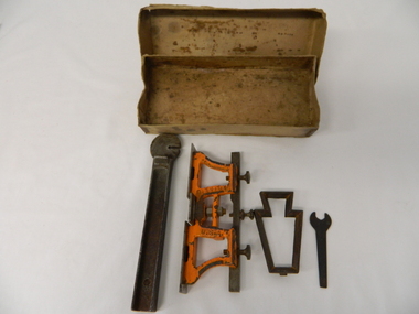 Kiewa Valley Historical Society
Spanner Small, 1920's
This spanner, part of a raker/jointer/guage set which is a sharpening tool for cross cut logging saws. The logging saws used in the early 1900's for the clearing of forests required constant sharpening of their "cutting teeth". The logging of forested areas during these times was very much a "hands on" method of either one or two men by the use of saw or hand axe. Chain saws, chain and ball(clearing) and bulldozing methods came in the mid 1900's.This particular spanner was part of a crosscut saw sharpening tool and method was used by surveyors laying down boundaries for the S.E.C. Victoria Hydro Electricity Scheme (1920's). This item was given to a local Kiewa Valley lad who accompanied the initial surveyors. The lad was responsible for the tendering and feeding of the surveyors "pack horses". Surveys during this period and in the dense mountainous terrain of the Victorian Alps was both exhausting and hazardous. Overnight accommodation at various log cabins was not always possible and swag/tent alternative was the "fall back"This small spanner is part of the Raker/Jointer Gauge saw set and is made from forged steel. The nut grip is of the two tightening nuts on the main construction frame. See KVHS 0090 (A &B) for the other items making up the sharpening tools.hand tool, saw, sharpening method, tree felling. -
 Bendigo Historical Society Inc.
Document - H. A. & S. R. WILKINSON COLLECTION: CONTRACT OF SALE
Contract of sale of land dated 26 March, 1956 between Mrs. I.M. Arthur (vendor) and Mr. W. R. & Mrs. V. L. O'Toole (purchaser). Property: piece of land part of Crown allotment 53 section A at Eaglehawk Parish of Nerring County of Bendigo and being land described in certificate of title volume 4870 folio 850 and situate 65 Peg Leg Road, Eaglehawk. Also all the land adjoining being part of Crown allotment 41 section A Parish of Nerring County of Bendigo land described in certificate f title volume 3198 folio 573, together with 6 room weatherboard and brick dwelling and all sundry outbuildings. Also all floor coverings, blinds, curtains and electric light fittings and shades. Price: 1,275 pounds.organization, business, h.a. & s.r wilkinson real estate -
 Orbost & District Historical Society
plan, before 1948
Drainage infrastructure was developed and maintained in this region by the Snowy River Improvement Trust. The Trust was administered by a local committee and its activities funded by a local rate charged on the farmers and land owners in the Trust’s designated district. The level of the rate charged by the Trust was designed to be proportionate to the benefit derived from the works undertaken. Financial assistance was provided by the State Government from time to time for specific projects such as post flood repairs but not for new capital works. The Trust undertook new drainage and river management works including tree planting, rock beach construction and servicing of the drains and flood gates. The Trust also provided a personal flood warning service to the farmers in its district. The Trust ceased to operate in 1997 with the advent of the East Gippsland Catchment Management Authority. The infrastructure developed by the Trust continues to provide a service to the farmers in the region. (ref. 4 East Gippsland CMA Submission to Inquiry into Flood Mitigation Infrastructure in Victoria) This plan is significant as a historical document. The Snowy River Improvement Trust was vital to the Orbost district because of its ability to apply local knowledge and to engage the local farming community.A large plan of divisions of land for the purpose of levying the Snowy River Improvement District - Bete Bolong, Orbost, Waygara, Newmerella and Orbost East. The properties are coloured according to levy amount. The scale is 1" - 20 chains. snowy-river-improvement-trust -
 Kew Historical Society Inc
Photograph - Flooding of the Yarra Valley at Kew East, 1974
Flooding of the Yarra Valley, including that section of the Yarra bordering Kew and Kew East in the north and west of the municipality, was a regular occurrence. Extreme flood events of the Yarra River are recorded to have occurred in 1891, 1901, 1916, 1923 and 1934. The Municipality of Kew's response to these floods was to enact planning decisions restricting residential development in flood prone areas following the floods of 1916, 1921 and 1934. While floods continued after the development of the Upper Yarra Reservoir (construction 1948-57), the regularity and extent of these inundations diminished. During the nineteenth century, the land abutting the south side of the Yarra in Kew was devoted to dairy farming. In the twentieth century, before and after the construction of the Eastern Freeway, much of this low-lying area was used as golf courses and public parks.Late example of the capacity of the Yarra Valley at Kew to flood, even though drainage works and the Upper Yarra Reservoir had reduced their regularity.Original black and white print photograph of the low-lying land at East Kew under floodwater on 16 May 1974. The vantage point of the photographer is Lister Street. Flooding was caused by overflowing water in Glass' Creek and the River Yarra. Annotation verso: "Lister Street looking north / Flood level / 16 May 1974 11.30am / R.L. 46.04"hays paddock, floods, yarra river, glass' creek, lister street -
 Kew Historical Society Inc
Photograph - Flooding of the Yarra Valley at Kew East, 1974
Flooding of the Yarra Valley, including that section of the Yarra bordering Kew and Kew East in the north and west of the municipality, was a regular occurrence. Extreme flood events of the Yarra River are recorded to have occurred in 1891, 1901, 1916, 1923 and 1934. The Municipality of Kew's response to these floods was to enact planning decisions restricting residential development in flood prone areas following the floods of 1916, 1921 and 1934. While floods continued after the development of the Upper Yarra Reservoir (construction 1948-57), the regularity and extent of these inundations diminished. During the nineteenth century, the land abutting the south side of the Yarra in Kew was devoted to dairy farming. In the twentieth century, before and after the construction of the Eastern Freeway, much of this low-lying area was used as golf courses and public parks.Late example of the capacity of the Yarra Valley at Kew to flood, even though drainage works and the Upper Yarra Reservoir had reduced their regularity.Original black and white print photograph of the low-lying land at East Kew under floodwater on 16 May 1974. The vantage point of the photographer is Lister Street. Flooding was caused by overflowing water in Glass' Creek and the River Yarra. Annotation verso: "Lister St looking same as No.3 / 16 May 1974 11.30"floods, yarra river, glass' creek, lister street -
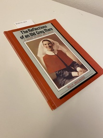
 Returned Nurses RSL Sub-branch
Book, Polly Underwood, The Reflections of an old grey mare : A salute to those who served
A record of nursing service in the second world war, from enlistment to peace.Soft cover, red and grey, containing a portrait of the author in army nurses' uniform. Australian Army Nursing Service uniform. Back cover, white with a facsimile of the Instrument of Surrender.non-fictionA record of nursing service in the second world war, from enlistment to peace.world war two, ww2, finschhafen, ambulance trains, wwii -
![Map, Plan of Town Allotments Bacchus Marsh [1873]](/media/collectors/5e461d8021ea67224c82f2a1/items/677a8ee7ab7bb47995c5573f/item-media/677a8fdeab7bb47995c55b56/item-fit-380x285.jpg) Bacchus Marsh & District Historical Society
Bacchus Marsh & District Historical SocietyMap, Plan of Town Allotments Bacchus Marsh [1873]
James Young was a prominent businessman, land owner and public figure in the early colonial period of Bacchus Marsh. After his death in 1871 land remaining from his estate in Bacchus Marsh was sold at auction in 1873. The sale of his estate included the substantial stone residence in Bennett Street which later became known as 'Stone Villa'. The sale of his land in 1873 was conducted by local auctioneer James Crook. 29 allotments were advertised for sale, although the plan for the sale indicated 30 allotments. The sale notice in the Bacchus Marsh Express of 11 October 1873 noted that the allotments were " in the very centre and heart of the most populous and business portion of the township, at the same time being the only remaining portion of the business block available for purchase by public sale, which fact intending purchasers should not lose sight of, as the opportunity cannot occur again". The designation of a new street, 'Bennett Street', shown on the plan, is also indicated in the advertising, "In reference to the main street frontages, opposite the Border Flour Mills. The Auctioneer would also direct attention to the plan, showing the formation of a new thorough fare (Bennett street) leading from Young street into Gell street, thus opening up the township on the high, more healthy, and commanding position so much to be desired for private dwellings".An important cartographic document which indicates an early major subdivision of land in the inner urban area of the Bacchus Marsh township. This subdivision lead to the continuing residential and commercial development of the township of Bacchus Marsh in the later part of the 19th century. The location of two well known demolished public structures, the Free Gardeners Hall in Gell Street, and the Old Mechanics Institute Hall (aka the Buffs Hall), on the corner of Young and Bennett Streets, are also shown on this map.A single page paper map showing 30 blocks of land for sale around 1873 in the vicinity of Bennett Street and Lerderderg Street. Described in contemorary sources as a 'lithographed copy'. No scale is indicated. The map is pasted into a bound volume containing 76 maps or plans in total. High resolution digital image stored on BMDHS computer network. land sales bacchus marsh, bacchus marsh victoria maps, james young 1816-1871, bacchus marsh roads and streets, bennett street bacchus marsh -
Port Melbourne Historical & Preservation Society
Document - Contract of Sale for 84 Dow Street, Port Melbourne, Law Institute of Victoria, 8 July 1982
The 1928 Contract of Sale is for the land which became 84 Dow Street, Port Melbourne. The land was sold by Catherine Fleming BARLOW of East Kew to Sydney William NEWMAN for the sum of 875 pounds. The deposit was 100 pounds with a quarterly re-payment of 10 pounds.Purchase completeddow street, built environment - domestic -
 Ringwood and District Historical Society
Document - Department of Lands and Survey, Wire Netting Branch, Melbourne, Victoria, Application for Vermin-Proof Fence Certificate - L.J. Mills vs John Collins, Grandview Grove, Ringwood, Victoria - 1939
Photocopied file of corresponence and documentation relating to a claim by L.J. Mills, Nurseryman, that adjoining property owner, J. Collins, Farmer, assists with replacement of a vermin proof wire netting dividing fence destroyed by 1939 bushfire. File includes 1939 and 1940 detailed property inspection reports by Vermin and Noxious Weeds Branch, Lands Department, Lilydale, describing land use in the area and signs of vermin activity. Application approved 18th April, 1940. Appeal lodged by Mr Collins disallowed in May, 1940. File closed June, 1940 with Departmental suggesion that Mr Mills consider further legal action through a Solicitor as fence had still not been wire-netted. TRANSCRIPTS: Vermin & Noxious Weeds Inspection Reports "19/9/1939 (To) Superintendent (Department of Lands and Survey, Melbourne) Re L.J. Mills application for Vermin Proof Fence. I called on Mr Mills yesterday 18th instant in connection with this matter. Mr Mills has a flower farm and claims that rabbits and hares are damaging his flowers. He showed me a bed of carnations which he stated were being damaged by rabbits. There was evidence of some leaves being nipped off, but I am unable to say whether this is due to rabbits or grubs. Very little if any real damage is being done. The property is netted on the east and south boundary and on half the north and west boundary. The surrounding country is undlating and fairly steep in places. The land to the east across Grandview Avenue (sic) is all planted out in old established orchards and well cultivated. Cleared grass land adjoins the south boundary and bush land adjoins the north and west boundaries. I walked over a large area surrounding Mr Mills land and never saw any rabbits or hares or any indications of rabbits. This locality is not rabbit infested and very little wire netting is being used. I do not consider that a vermin proof fence is necessary between these allotments. - Jas H Allison (Inspector, Vermin and Noxious Weeds Branch, Lands Department, Lilydale)." Follow up report following renewal of application for Certificate by Mr Mills, citing rabbits causing considerable damage to his flowers. He laid poison and obtained 9 carcases and stated that there is evidence of rabbit infestation from the adjoing land. "19/3/1940 (To) Mr Hannah (Superintendant, Department of Lands and Survey, Melbourne) Re L.J. Mills, Grandview Grove Ringwood, Lot 4 Grandview Estate Pt CG20 Ph of Warrandyte. I interviewed Mr Mills at his home on 15th inst. He showed me carcases of rabbits which he stated had been poisoned on his land. In places young plants had been nipped off apparently by rabbits. I made an inspection of adjoining properties and found one live burrow close to Mr Mills northern boundary. There were scratches and other evidence of rabbits on land north and west of Mr Mills property. In view of the present evidence of rabbits I consider that a vermin proof fence is now necessary to protect the flowers grown by Mr Mills. His land is netted on whole of east and south boundary and half way on west and north boundary. The adjoining land on west and north boundaries is owned by Mrs Linda Collins and John Collins resp of Brysons Road East Ringwood. - Jas H Allison (Inspector, Vermin and Noxious Weeds Branch, Lands Department, Lilydale)." -
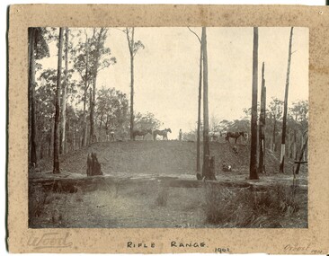 Orbost & District Historical Society
black and white photograph, Wood, 1901
This photograph appears to have been taken during the construction of the rifle range just north of the Orbost township. "The photo shows the range stop butt being formed by the scoops being pulled by the horses. It appears that the rear of the mound there is a wall of logs lining it, most likely to help with being eroded or washed away. They haven’t yet formed the mantlet and target machines." ( Info, from Victorian Rifle Association) The Orbost Rifle Club existed in the early 20th century. (There are records from 1900). It folded in the late 1970's.Target shooting is one of the oldest organised sports in Australia. Records date back to the British Marines at Sydney Cove in 1788. The Victorian Rifle Association (VRA) was formed in 1860. After Federation in 1901, rifle clubs came under army control, but in 1921 they were reconstituted as a civilian organisation, which they have remained ever since. After World War I a system of national training was embodied in the Defence Act and the rifle clubs reverted to their purely sporting role. A black / white photograph of four men and four horses standing an a soil bank with another man, a lady and a small girl at the base of the hill. It is in a clearing in forest. It appears to have a row of targets set at the edge of the bank. The photograph is mounted on a very mouldy cream coloured buff card.on front - "Wood" ; "Rifle Range - 1901" ; "Orbost 1901"sport-shooting orbost-rifle-range