Showing 110061 items matching "roads"
-
 Whitehorse Historical Society Inc.
Map, Site for Wesleyan Church, Nunawading, 1855
Photocopy of manuscript map showing names of landholders.Photocopy of manuscript map showing names of landholders. Note on verso: Plan of allotments in the City of Melbourne appropriated to the Wesleyans. Site for Wesleyan Church, Nunawading 1848 (Corner of Burwood and Elgar Roads - S of Burwood, W of Elgar)Photocopy of manuscript map showing names of landholders. churches, wesleyan church, burwood, burwood road, burwood, elgar road, burwood, maps -
 Halls Gap & Grampians Historical Society
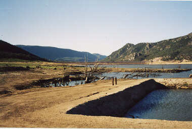
Photograph - Coloured, C 2007
This is a photo of the exposed swimming pool of Myrtlebank, which became exposed in Lake Bellfield during the drought years (2007 - ). The view is looking towards the dam wall and further road through the valley..Photo shows an exposed swimming pool (Myrtlebank Pool) in a very low reservoir (Lake Bellfield). There are dead branches in the water behind the pool and the dam wall and former road through the valley can be seen in the background.recreation, swimming pool -
Whitehorse Historical Society Inc.
Article, Kilns Inspected, 1994
Printedd Article in Nunawading Gazette.Article in Nunawading Gazette, Historic Buildings Council believes the old Kilns and Chimneys on the Monier site in Mitcham Road are of State significance and should be retained, but the Company has appealed to Mr. MacLellan to allow them to demolish.Printedd Article in Nunawading Gazette.pottery kilns, monier limited, historic buildings council -
 Lakes Entrance Historical Society
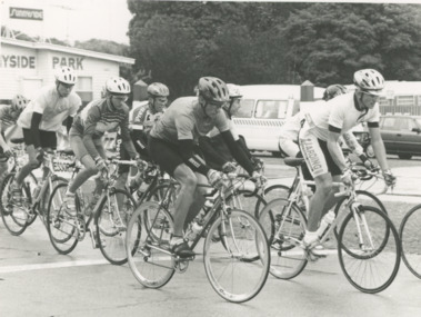
Photograph - Gippsland Games Senior Criterium, Lakes Post Newspaper, 1/03/1995 12:00:00 AM
road cyclists taking part in the Gippsland Games Senior Criterium event sponsored by Lakes Entrance RSL showing cyclists passing Sunnyside Park Myers Street Lakes Entrance VictoriaBlack and white photograph of road cyclists taking part in the Gippsland Games Senior Criterium event sponsorded by Lakes Entrance RSL showing cyclists passing Sunnyside Park Myers Street Lakes Entrance Victoriasports, cycling, recreation -
 Kiewa Valley Historical Society
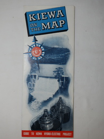
Map - Kiewa on the Map, Guide to Kiewa Hydro-Electric Project
Published by the SECV in 1950. They controlled the roads from Mt Beauty to the Bogong High Plains and all other roads within the Kiewa works area. The roads are not open to general tourist traffic. Conducted tours of the Kiewa area are operated by Eastern Road Lines Pty. Ltd., AlburyThe SECV constructed the KHES and controlled all roads within the Kiewa works area.Large colored map folded in half and then in 3. Front third is mostly blue and white with titles.. When opened the cover has black and white photos beside it with print and 'Please Note'. Also in the other half, a 'Road Map to Kiewa' showing the south eastern side of Australia, mostly yellow (the land) and blue (the sea). Inside the map is a close up map of "Ground Plan of Kiewa Hydro Electric Project' with a 'Key Map Showing Distances'.map of kiewa 1950, khes map -
 Surrey Hills Historical Society Collection
Photograph, Union Road looking west from the steeple of Holy Trinity Church, 1922, 1922
At the edge of the church roof and on the horizon is 'The Knoll' on the corner of Union Road and Wandsworth Road. To the left of this is 297 Mont Albert Road, home of the Michael Parer family and further left is "Quamby", home of the Sherar family. This is easily recognised by the square viewing tower located on the west wing of the house. The Sherar family owned 'Quamby' from 1900 until 1925, when it became Mosgiel Private Hospital. Norman Carter took many photos of Surrey Hills and Mont Albert in the 1920s; many associated with events and activities of the Church of England. Black and white photo of taken from the steeple of Holy Trinity Church, during its construction, across Union Road to the north-west. In the foreground immature street trees can be seen and an original telephone pole with white insulators. The street has formed paths and bluestone kerb and channelling. holy trinity anglican church, union road, the knoll, quamby, street trees, telegraph and light poles, mosgiel hospital -
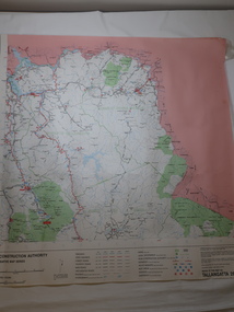 Kiewa Valley Historical Society
Map - Road Construction Authority 1986, Ref. Tallangatta 282008
Government authorities updated maps regularly.Historically of interest eg. 1. Pre dates the Alpine National Park. 2. 'Mt Beauty Estates' now known as Tawonga South. 3. Mt Niggerhead is named - It is now known as Mt Jaithmathang having been renamed in 2009.Colored map dated 1986 titled Road Construction Authority with an update of roads in the local Shires. It names places in the area and has a legion describing the rating of the roads and tracks. It also shows the main towns in the area and their roads.road construction authority, map of tallangatta area -
 Ringwood and District Historical Society
Pamphlet, Subdivisional Auction Sale, Bedford Park, Ringwood - 1924
Bedford Park subdivisional development did not eventuate. The land adjoining the railway line became parkland with provision for sporting facilities and the remainder was purchased by the Education Department as the site for Ringwood High School/Secondary College. Double sided bifolded auction sale advertisement including subdivision features and local facilitiesSubdivision plan includes Bedford Road, Graham Road, Joyce Street, Anderson Street, and Adams Street -
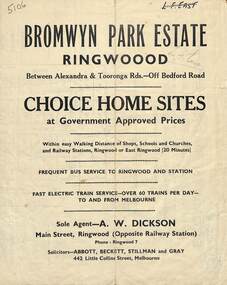 Ringwood and District Historical Society
Flyer, Bromwyn Park Estate, Ringwood - 1946 - Avertising Brochures and Map
Two pages of subdivision features, services and locationSubdivision plan includes Alexandra Road, Marwarra Street, Tooronga Road, Hilary Grove, Morcom Avenue. -
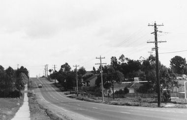 Ringwood and District Historical Society
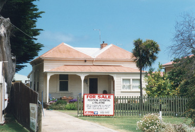
Photograph, Northward view from Mullum Road corner, Oban Road, Ringwood - 1981
Written on back of photograph, "E622, N6, 1981. Oban Road between Mullum and Wonga Roads (on skyline)".. -
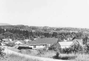 Ringwood and District Historical Society
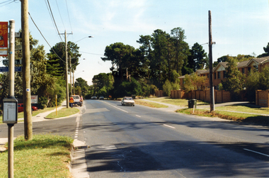
Photograph, Ringwood East looking from corner Warrandyte Road and Wonga Road, 1960
Written on back of photograph, "Ringwood East looking from corner Warrandyte Road and Wonga Road, 1960". -
 Ringwood and District Historical Society
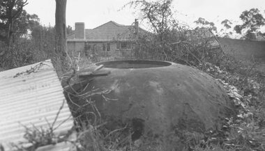
Photograph, Old well at the corner of Warrandyte Road and Oban Road (N.E. corner) - 1964
Typed below photograph, "Old well at corner Warrandyte Road and Oban Road (N.E. corner) - 1964". -
 Ringwood and District Historical Society
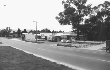
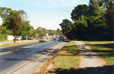
Photograph, Canterbury Road shops, corner Armstrong Road, Heathmont, looking east - 1973
Catalogue card reads, "Canterbury Road shops, corner Armstrong Road, Heathmont, looking east - 1973". -
 Geelong Cycling Club
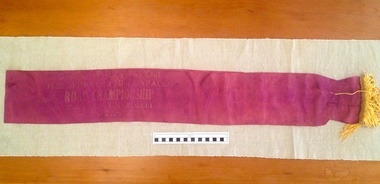
Sash, 1952
The sash was awarded to G. Lunardelli as the winner of the Senior 20 mile Road Championship for GWCC. Lunardelli came out from Trieste, Italy after World War 11 and worked for the Geelong Water Board. Lunardelli subsequently ceased full time cycling in order to make a living.This award indicates the important influence that immigrants had on the popularity and depth of cycling at the time in the Geelong region. Cycling was and continues to be very popular in Europe.Burgundy satin sash with gold tassel finish at one end. It has faded gold embossed inscriptions on it."Geelong West Cycling Club/1952 Senior 20 Mile Unpaced/Road Championship/ Won by G. LUNARDELLI/Time 56mins5 2/5 seconds"sash; geelong west cycling club; lunardelli; 1952; road championship; -
Hand Tool Preservation Association of Australia Inc
Road tamper
This item is part of the Thomas Caine Tool Collection, owned by The National Trust of Australia (Victoria) and curated by the Hand Tools Preservation Association of Australia.road tamper -
 Kew Historical Society Inc
Plan - Subdivision Plan, Corsewall Estate, 1938
The Kew Historical Society collection includes almost 100 subdivision plans pertaining to suburbs of the City of Melbourne. Most of these are of Kew, Kew East or Studley Park, although a smaller number are plans of Camberwell, Deepdene, Balwyn and Hawthorn. It is believed that the majority of the plans were gifted to the Society by persons connected with the real estate firm - J. R. Mathers and McMillan, 136 Cotham Road, Kew. The Plans in the collection are rarely in pristine form, being working plans on which the agent would write notes and record lots sold and the prices of these. The subdivision plans are historically significant examples of the growth of urban Melbourne from the beginning of the 20th Century up until the 1980s. A number of the plans are double-sided and often include a photograph on the reverse. A number of the latter are by noted photographers such as J.E. Barnes.The Corsewall Estate was a subdivision, bordering on Barkers Road and Auburn Road, which created Corsewall Close. This relatively late subdivision included 29 allotments. The subdivision plan includes the dimensions of each lot as well as the width of the existing and projected roads and turning circles. The Corsewall Close Precinct is now listed on the Victorian Heritage Database (HO147) and is noted for its ‘consistent flat-type development over the entire street, which has been cleverly designed to make multi-unit dwellings appear as single buildings’.subdivision plans - hawthorn, corsewall estate -- hawthorn (vic.) -
 Lakes Entrance Historical Society
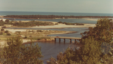
Photograph - North Arm Bridge, road to Bullock Island, build up of sand spit later site for Fishing Club and boat ramp, Lakes Entrance Victoria, G W Holding, 1/04/1979 12:00:00 AM
North Arm Bridge, road to Bullock Island, build up of sand spit later site for Fishing Club and boat ramp, Lakes Entrance Victoria. Taken during the King of the Straits eventColour photograph taken from Kalimna Heights showing North Arm Bridge, road to Bullock Island, build up of sand spit later site for Fishing Club and boat ramp, Lakes Entrance Victoria waterways, islands, bridges -
 Lakes Entrance Historical Society
Photograph - Historic House, Holding M, 2004
Building was originally part of Mrs Carstairs Boarding House at New Works. Relocated to rear of Carstairs Heyfield House. Occupied by Orme Crawford, garage proprietor, motor mechanic in 1930's. Tommy Kent, garage proprietor, 1950's to 1960's. (Local knowledge)|Also nine photographs various views of the transportation of the house to Ostlers road Lakes Entrance.Colour photograph of a residence in Marine Parade, prior removal from site by Plymin Transport to a location on corner of Colquhoun and Ostlers Roads. Lakes Entrance Victoriahouses, local history -
 Whitehorse Historical Society Inc.
Photograph, Prior to Widening of Mitcham Road, 1/02/2000 12:00:00 AM
Coloured photograph of Mitcham Road looking towards Doncaster. Hedge End Road on left, Wrendale Drive on right. Prior to construction of widening of Mitcham Road.mitcham road, donvale, hedge end road, mitcham, wrendale drive -
 Whitehorse Historical Society Inc.
Photograph, Mitcham Road Before Widening, 1/02/2000 12:00:00 AM
Coloured photograph of Mitcham Road looking towards Doncaster. Donvale Nursery on right at end of road. Taken before construction began to widen Mitcham Road.mitcham road, donvale -
 Whitehorse Historical Society Inc.
Article, Intersection Needs Remedy, 2020
Cars trying to make right turns from Rooks Road & Dunlavin Road on to Whitehorse Road end up on a collision course and the problem needs remedyingCars trying to make right turns from Rooks Road & Dunlavin Road on to Whitehorse Road end up on a collision course and the problem needs remedying.Cars trying to make right turns from Rooks Road & Dunlavin Road on to Whitehorse Road end up on a collision course and the problem needs remedyingwhitehorse road, rooks roads, dunlavin road, mitcham road, springvale road, city of whitehorse, nunawading -
Canterbury History Group
Photograph - G. Robinson's butcher shop, [1900]
Window display in G. Robinson's first butcher shop in Canterbury Road, opposite Highfield Road. In 1906 the business moved to 265-267 Canterbury Road.canterbury, butcher shops, gas lamps, canterbury road, robinson> george, window displays, food -
Clunes Museum
Map, G.J. WILLIAMS, SHIRE OF TALBOT & CLUNES, UNKNOWN
BLACK AND WHITE HAND DRAWN MAP. SHIRE OF TALBOT & CLUNES. SHOWING SEALED ROADS, GRAVEL ROADS AND PARTLY FORMED ROADS. SCALE 1:100,000map, clunes, talbot -
 Eltham District Historical Society Inc
Slide - Photograph, Lomic Court, Templestowe, c.Mar. 1985
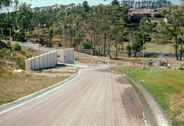
... roads ...Eltham Shire Council officers would benchmark road infrastructure in surrounding local government areas. In this case, a private street scheme in a new housing development on Lomic Court, Telmplestowe in what is present-day Manningham City Council. Areas of interest in the photo are the roll over concrete kerbs, brick paving and drainage.35mm colour positive transparency (1 of 15) Mount - Kodak Kodachrome Cardinfrastructure, roads, city of manningham, footpaths and gutters, housing estates, templestowe, lomic court -
 Eltham District Historical Society Inc
Slide - Photograph, Lomic Court, Templestowe, c.Mar. 1985
... roads ...Eltham Shire Council officers would benchmark road infrastructure in surrounding local government areas. In this case, a private street scheme in a new housing development on Lomic Court, Telmplestowe in what is present-day Manningham City Council. Areas of interest in the photo are the roll over concrete kerbs, brick paving and drainage.35mm colour positive transparency (1 of 15) Mount - Kodak Kodachrome Cardinfrastructure, roads, city of manningham, footpaths and gutters, housing estates, templestowe, lomic court -
Whitehorse Historical Society Inc.
Book, Nubrik heritage value assessment, 1/12/1999 12:00:00 AM
Heritage value assessment of the proposed H062 former Brick Industries Ltd / Brick and Pipe Industries Ltd (Nubrik) BrickworksHeritage value assessment of the proposed H062 former Brick Industries Ltd / Brick and Pipe Industries Ltd (Nubrik) Brickworks, 78 Middleborough Road, Burwood East. Prep. for the owners, Reading Entertainment Australia Pty Ltd [by] D.V. Bick. Abridged version.Heritage value assessment of the proposed H062 former Brick Industries Ltd / Brick and Pipe Industries Ltd (Nubrik) Brickworksbrick industries limited, middleborough road, burwood east, no. 78, brickworks, quarries, reading entertainment australia pty ltd -
 Lakes Entrance Historical Society
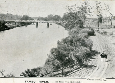
Postcard - Bridges, 1906
First timber road bridge over the Tambo River at Swan Reach officially opened 20 December 1905, after which punt was removed to BairnsdaleBlack and white postcard of the lifting bridge over the Tambo River at Swan Reach, Victoria. Man on horse standing on dirt road to Metung beside the river. Punt previously used to cross river visible against western bank of river.Tambo River (16 miles from Bairnsdale)bridges, waterways -
 Eltham District Historical Society Inc
Slide - Photograph, Aerial Photo (c.1987): Main Road, Fitzsimons Lane, Lower Plenty, c.Aug. 1990
... roads ...Part of a presentation, "Roads and Byways of the Shire of Eltham", by Russell Yeoman to the 12 September 1990 Society meeting. Slides shown included copies of old photos and recent images ranging from the suburban streets of Eltham and Montmorency to the mountain roads of Kinglake. In the byways category are views of some iof the Shire's bicycle paths including then recently completed sections of the Main Yarra Trail at Lower Plenty.35mm colour positive transparency (1 of 37) Mount - Agfachrome Agfa CS System black 8 dotsinfrastructure, roads, aerial photographs, roundabout, bolton steet, bolton steet shops, eltham, fitzsimons lane, lower plenty, main road -
 Glen Eira Historical Society
Album - Album page, Booran Road, 30, Circa 1972
This photograph is part of the Caulfield Historical Album 1972. This album was created in approximately 1972 as part of a project by the Caulfield Historical Society to assist in identifying buildings worthy of preservation. The album is related to a Survey the Caulfield Historical Society developed in collaboration with the National Trust of Australia (Victoria) and Caulfield City Council to identify historic buildings within the City of Caulfield that warranted the protection of a National Trust Classification. Principal photographer thought to be Trevor Hart, member of Caulfield Historical Society. Most photographs were taken between 1966-1972 with a small number of photographs being older and from unknown sources. All photographs are black and white except where stated, with 386 photographs over 198 pages. From Glen Eira Heritage Management Plan 1996 by Andrew Ward: In 1888, John Leek, a trainer, owned Lot 15, measuring one and three quarter acres, in Booran Road, north side between Glen Eira and Neerim Roads. The land backed onto the Caulfield Racecourse Reserve. NAV was £45. In 1890 Leek built for his residence, a ten roomed brick house on the site. NAV was £200. Leek was the owner/trainer of "Ingliston" who won the Caulfield Cup in 1900. Upon the horse's death in 1901, Leek is understood to have defied tradition by spending £20 on boots for the "ragged urchins in Bourke Street" instead of "shouting" at the bar. By 1899, the property was owned and occupied by Alfred Merrill, a dentist and was known as "Andover". NA V had decreased to £ll0. By 1910, Leslie Macdonald, a gentleman had purchased the property and renamed it "Moidart". In 1910-11 Macdonald sold it to John Robertson. The property had extensive wood stables on its north-east boundary and several other outbuildings. The house continued to be described as "Brick, ten rooms" as it was in 1926 when it was owned and occupied by John Arthur, a managing director. The land measured la.2r.31p. and had a NAV of £235. Nine people lived there. In 1926, Arthur also owned the adjoining Lot 16. Other racehorses of note, known to have been stabled here include Sobar, Havelock, Proud, Future and Lord.Victorian Heritage Register https://vhd.heritagecouncil.vic.gov.au/places/13532 What is significant? Lord Lodge is a thoroughbred racehorse training complex adjacent to Caulfield Racecourse, established in 1890. The area immediately around the racecourse has been associated with horse racing activities and businesses servicing the industry since the development of the racecourse in late the 19th century. Lord Lodge was named by the present occupants after the champion racehorse Lord who was stabled there in the 1950s. In the early 20th century the property was known as 'Andover' and subsequently 'Moidart'. The site consists of a single storey brick Italianate villa, jockeys' quarters, stables and open day yards with direct access to Caulfield racecourse from the rear of the property. The villa of 10 rooms on bluestone foundations was constructed in 1890 by John Leek, a horse trainer who purchased the newly subdivided land in 1888. The house has many Victorian Italianate or Boom Style features although it is more modest than many villas of its style. It has an asymmetrical facade with a faceted bay window and a prominent central tower with low pitch pyramidal roof that provides a clear view of the racecourse. Other characteristic features include stilted segmented arches, bracketed eaves, stucco wall finish and cast cement ornamentation. A room has been added on the north-facing verandah in sympathetic style and finish. Internally the rooms are substantially intact with original marble fireplaces and intricate ceiling roses and cornices. An entrance toward the rear of the southern side of the house is said to be where the stable hands, jockeys and other staff lined up for their meals. In the southeast corner of the property, backing directly on to Caulfield racecourse, is a substantial late Victorian timber stable, probably constructed in the 1890s but first appearing on the property title in 1910. The stable has 12 stalls, a loft and brick pavement and jerkin head roof form with varnished pine-lined ceiling carried on a chamfered timber frame. It has an original roof lantern. The doors of the stalls are not the original sliding doors but swing doors obtained from a barn at Epsom Racecourse in Mordialloc prior to demolition. Outside the gambrel roof has fretted barges but the building is otherwise utilitarian. Timber throughout the stalls has been worn by chewing and rubbing of horses over the century of its use. In the southern half of the property are open day yards where the racehorses are kept during the day. The red brick, single storey jockeys' quarters to the rear of the villa were probably built around 1950. A small brick, possibly late Victorian structure on the eastern boundary thought to have originally been a gardening shed, has been converted to a stable of two stalls. Modern concrete brick stables fill the northeast portion of the property. At the front of the property two Moreton Bay Figs (Ficus macrophylla), probably planted in the late 19th century, provide shade for horses in the day yards. In the 1890s John Leek sold the property, relocating his training facility to one of the newly established racecourses at Mentone or Mordialloc (Epsom). By 1899, the property was owned and occupied by Alfred Merrill, a dentist, who named the property 'Andover'. In 1910 it was purchased by Leslie McDonald, a gentleman, and renamed 'Moidart'; sold in 1910-1911 to John Robertson; and again in 1926 to John Arthur, a racehorse owner. The Victorian Amateur Turf Club purchased the property in the late 1930s and since this time has been leased to racehorse trainers. It is unclear whether the property operated as a training facility between 1899 - 1926. Several notable trainers and jockeys are associated with Lord Lodge. The best known is Arthur 'Scobie' Breasley, Australia's most successful jockey who was apprenticed to trainer Pat Quinlan at Lord Lodge (then 'Moidart') from 1928 - 1935. Breasley rode winners of the Caulfield Cup in four successive years 1942-45 and again in 1952. John Leek, the original owner of Lord Lodge trained Ingliston, the 1900 Caulfield Cup winner. Along with 'Lord' a number of well known racehorses including Sobar, Havelock, Proud and Future were trained at Lord Lodge .....Page 40 of Photograph Album with three landscape photographs of the exterior of this house.Handwritten: 30 Booran Road [top right hand corner] / 40 [bottom right]trevor hart, jenny o'donnell, booran road, mansion, caulfield east, ingliston, sobar, havelock, proud, future, lord, andover, moidart, lord lodge, grace darling, caulfield racecourse reserve, victorian amateur turf club, historic buildings register, national estate register, caulfield cup, horses, stables, horse racing, racehorses, outbuildings, racehorse trainers, depression, 1890s, brick houses, mansions, towers, verandahs, stained glass, italianate style, victorian style, architectural features, architectural styles, john leek, leslie macdonald, john arthur, john robertson, alfred merrill, jenny odonnell -
 Ringwood and District Historical Society
Flyer, Land Sale Advertisement - Sunbeam Estate, East Ringwood, Victoria - circa 1930
Folded double-sided page advertising private sale of 48 residential allotments, with location map, terms of sale, and details of local features and services. Locality plan includes Holland Road, Everard Road, Sunbeam Avenue, Mount Dandenong Road, and Lilydale Road (later Old Lilydale Road). (Agents) Phillips & Nicholson, 59 Swanston Street, Melbourne, (Phone) Central 10907, in conjunction with C.E. Carter, Bank Chambers, Main Street, Ringwood, Telephone Ringwood 24.