Showing 221 items
matching architectural feature
-
 Ballarat Heritage Services
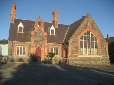
Photograph - Photograph - Colour, Dana Street Primary School From Doveton Street, Ballarat, c2007
Dana Street Primary School No 33 is one of Ballarat's earliest schools. A number of colour photographs of Dana Street Primary School, Ballarat. The photographs feature the original bluestone building, chimney, and other architectural features. The photos were taken at 7am.dana street primary school, dana street state school, bluestone -
 Ballarat Heritage Services
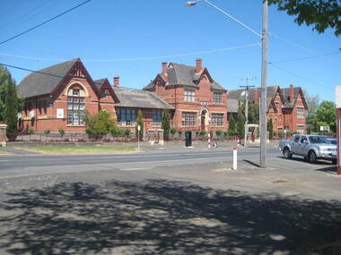
Photograph - Photograph - Colour, Clare Gervasoni, Macarthur Street Primary School, Ballarat, 2010, 06/11/2010
Macarthur Street Primary was constructed in 1877 and officially opened on 31 May 1878, replacing the Soldiers Hill School. It has an initial enrolment of 650 students. Its first head teacher was William Cox.Colour photographs of Macarthur Street Primary School, Ballarat. The photographs feature the original red brick building, chimney, and other architectural features. macarthur street primary school, macarthur street state school, red brick, schools, education, macarthur street ballarat, soldier's hill -
 Robin Boyd Foundation
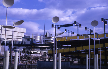
Slide, Robin Boyd, 1967
Robin Boyd was appointed Exhibits Architect for the Australian Pavilion at Expo ‘67 in Montreal. The garden outside the pavilion featured a sculptural pool, a coral display, animal pool, a pit for kangaroos and Eucalypts and other native plants. The indoor exhibits covered aspects of Australian art and culture, architecture, industrial design and scientific innovation, such as the Snowy Mountains Hydro-Electric Power Scheme, the Parkes radio telescope, the design of Canberra, and the Australian way of life.Colour slide in a mount. Uplights of the British Pavilion (foreground), French Pavilion (background) Expo 67, Montreal, CanadaMade in Australia / 27 / MAY 67M6 / 16 (Handwritten) / 3 (Handwritten)expo 67, montreal, robin boyd, slide -
 Robin Boyd Foundation
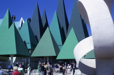
Slide, Robin Boyd, 1967
Robin Boyd was appointed Exhibits Architect for the Australian Pavilion at Expo ‘67 in Montreal. The garden outside the pavilion featured a sculptural pool, a coral display, animal pool, a pit for kangaroos and Eucalypts and other native plants. The indoor exhibits covered aspects of Australian art and culture, architecture, industrial design and scientific innovation, such as the Snowy Mountains Hydro-Electric Power Scheme, the Parkes radio telescope, the design of Canberra, and the Australian way of life.Colour slide in a mount. Canadian Pulp and Paper Pavilion, Montreal Expo '67, Canada. (Architect: William Kissiloff.)Made in Australia / 31 / MAY 67M6 / 6 (Handwritten) / 42 (Handwritten)expo 67, montreal, robin boyd, slide -
 Robin Boyd Foundation
Slide, Robin Boyd, 1967
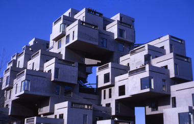
Robin Boyd was appointed Exhibits Architect for the Australian Pavilion at Expo ‘67 in Montreal. The garden outside the pavilion featured a sculptural pool, a coral display, animal pool, a pit for kangaroos and Eucalypts and other native plants. The indoor exhibits covered aspects of Australian art and culture, architecture, industrial design and scientific innovation, such as the Snowy Mountains Hydro-Electric Power Scheme, the Parkes radio telescope, the design of Canberra, and the Australian way of life.Colour slide in a mount. Habitat 67, Montreal, Canada. (Architect: Moshe Safdie.)Made in Australia / 37 / MAY 67M6 / Encircled 6 (Handwritten) / 24 (Handwritten) / 10 (Handwritten)expo 67, montreal, robin boyd, slide -
 Robin Boyd Foundation
Slide, Robin Boyd, 1967
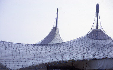
Robin Boyd was appointed Exhibits Architect for the Australian Pavilion at Expo ‘67 in Montreal. The garden outside the pavilion featured a sculptural pool, a coral display, animal pool, a pit for kangaroos and Eucalypts and other native plants. The indoor exhibits covered aspects of Australian art and culture, architecture, industrial design and scientific innovation, such as the Snowy Mountains Hydro-Electric Power Scheme, the Parkes radio telescope, the design of Canberra, and the Australian way of life.Colour slide in a mount. West German Pavilion, Montreal Expo '67, Canada. (Architects: Frei Otto and Rolf Gutbrod.)Made in Australia / 5 / APR 67M4 / Encircled 27 (Handwritten)expo 67, montreal, robin boyd, slide -
 Robin Boyd Foundation
Slide, Robin Boyd, 1967
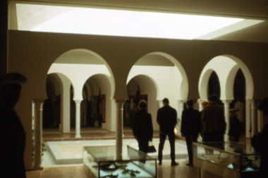
Robin Boyd was appointed Exhibits Architect for the Australian Pavilion at Expo ‘67 in Montreal. The garden outside the pavilion featured a sculptural pool, a coral display, animal pool, a pit for kangaroos and Eucalypts and other native plants. The indoor exhibits covered aspects of Australian art and culture, architecture, industrial design and scientific innovation, such as the Snowy Mountains Hydro-Electric Power Scheme, the Parkes radio telescope, the design of Canberra, and the Australian way of life.Colour slide in a mount. Tunisia Pavilion, Expo '67, Montreal, CanadaMade in Australia / 28 / MAY 67M6expo 67, montreal, robin boyd, slide -
 Bayside Gallery - Bayside City Council Art & Heritage Collection
Work on paper - ink and watercolour, Annette Meikle, Sandringham Club, 1977
In 1977, artist Annette Meikle undertook a commission to illustrate a book recording stories of places and people in the Bayside area. It was published in 1978 as Sandringham Sketchbook, with text by Elizabeth Waters. The sketches were intended to record remaining examples of Bayside’s early architecture and environment, as well as reflect newer architectural changes. Meikle went on to donate 22 of these sketches to Bayside City Council in 2003. In the mid 1870s wealthy solicitor David Abbot bought a large block on the corner of Bamfield Street and Beach Road and built an imposing family home with a stately tower. It featured rare Hawthorn Blacks – hand-made bricks of brown-red with streaks of charcoal black. For many years the home was the most prominent in the district. In 1922 ‘Coggeshall’ was subdivided, and the house was sold to the Sandringham Club, a gentleman’s club that had formed in 1913 and required more space for its growing membership. Members enjoyed lawn tennis courts, a bowling green and a cricket green, as well as a large billiard room. The Sandringham Club still owns ‘Coggeshall’.Annette Meikle, Sandringham Club 1977, ink and watercolour, 25.7 x 35.7 cm. Bayside City Council Art and Heritage Collection. Donated by the artist, 2003annette meikle, sandringham sketchbook, elizabeth waters, sandringham, sandringham club, gentleman’s club, coggeshall, david abbot, historic house -
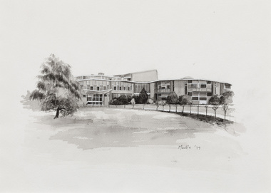 Bayside Gallery - Bayside City Council Art & Heritage Collection
Work on paper - ink and watercolour, Annette Meikle, Sandringham Hospital, 1977
In 1977, artist Annette Meikle undertook a commission to illustrate a book recording stories of places and people in the Bayside area. It was published in 1978 as Sandringham Sketchbook, with text by Elizabeth Waters. The sketches were intended to record remaining examples of Bayside’s early architecture and environment, as well as reflect newer architectural changes. Meikle went on to donate 22 of these sketches to Bayside City Council in 2003. Tasmanian architect J.H. Esmond Dorney developed this ground-breaking design for the Sandringham Hospital, which opened in 1964. Dorney had spent significant time recuperating in hospital in the post-war years and developed a special interest in hospital design. The hospital included circular wings with nurses’ stations at the hub and wards radiating outwards like spokes on a wheel. The hospital included 100 beds, two operating theatres and four delivery rooms and baby nurseries. Each ward of two to four beds had its own bathroom, and featured wide windows with garden views. The design was considered radical at the time and was copied as far afield as England and the United States.Annette Meikle, Sandringham Hospital 1977, ink and watercolour, 25.5 x 35.5 cm. Bayside City Council Art and Heritage Collection. Donated by the artist, 2003annette meikle, sandringham sketchbook, elizabeth waters, sandringham hostpital, jh esmond dorney, hospital, architecture, sandringham -
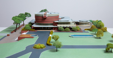 Bayside Gallery - Bayside City Council Art & Heritage Collection
Model, Alan W. Chandler, Brighton Municipal Complex, 1959
This model of the Brighton Municipal Offices was made by Alan W. Chandler. The Brighton Municipal Offices were designed by Kevin Knight of Oakley and Parkes with the engineers John Connell and Associates and were erected by Prentice Builders Pty Ltd. The foundation stone was laid on 13 February 1959 and the building was opened on 21 July 1961. The interior decoration and furniture was by Grant Featherston. As is common practice, an architectural model was prepared to present the final concept of the building for approval to the Brighton City Council. In February 1959 festivities occurred to celebrate the centenary of the municipality of Brighton. A garden party attended by two hundred Brighton residents was held in the grounds of the Brighton Town Hall. This model graced the centre of the lily pond during the event. The following day the foundation stone of the Brighton Municipal Offices was laid.Architectural model of a large public building in orange brick, the main cylindrical tower is set within a rectangular structure, with circular and oval roof structures. The model is set within landscaped grounds with paths, a water feature, several trees and bushes, lawns and flower beds.brighton municipal complex, brighton civic centre, brighton chambers, architectural model, model, alan w. chandler, kevin knight, oakley and parkes, architecture, municipal offices, municipal building, scale model -
 Buninyong & District Historical Society
Photograph - B/W photograph, Clifton Villa, Buninyong
Early house reflecting a degree of wealth, built for Buninyong Chemist around 1859historical and architectural elementsB/W photo of Clifton Villa, family dwelling built c 1859 cnr Eyre and Winter Streets Buninyong, lacework on barge boards and veranda, special feature chimneys. House built for Mr Newman,, chemist in Buninyong.clifton villa, house, garden, streetscape -
 Kew Historical Society Inc
Photograph - Photographs [Series], Robert Baker, Display: Model Kitchen of the 1920s, Kew Library, 2014, 2014
The Kew Historical Society, founded in 1958, is one of the oldest continuing historical societies in the Greater Melbourne region. From its beginnings, the Society has mounted exhibitions and/or displays, in early days in shop windows and in community spaces located in the Kew City Hall (later Kew Library), and since 2010 at the Kew Court House. Exhibitions typically coincided with the annual Kew Community Festival in March, but after 2013 evolved into three new exhibitions yearly at the Kew Court House. Smaller displays continue to be mounted in the Kew Library. One of two photographs of a display at the Kew Library, curated by Les Littlechild featuring items from the Kew Historical Society's and from private collections, of a model 1920s kitchen in Kew.kew historical society - exhibitions, australian dometsic architecture - kitchens - 1920s -
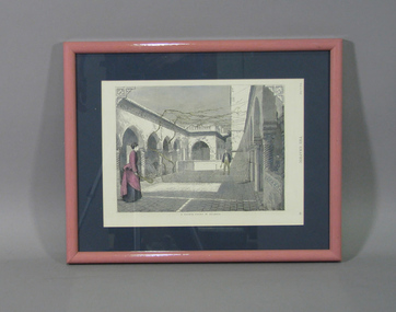 Tennis Australia
Page from Magazine, 1875
Page from The Graphic (page 45, July 10, 1875) featuring partly coloured lithograph depicting a man and woman playing tennis in an enclosed courtyard. Architecture is North African. Title caption reads: 'A TENNIS COURT IN ALGERIA'. Materials: Ink, Paper, Glass, Metal, Adhesive label, Plastictennis -
 Kew Historical Society Inc
Plan - 30 Choice Home Sites in Kilby Road, Meldrum Street and Fairway Drive, 1965
Subdivision plans and real estate flyers/brochures reveal a number of aspects of urban development and history. The Kew Historical Society's collection of these plans, as well as advertisements extracted from magazines, cover key aspects of community development and architectural history of Kew and Kew Eat as well as surrounding suburbs. While most of the plans in the collection were gifted to the Society by the former City of Kew, a number of other plans and advertisements have been donated by individuals, of which this is an example.Original 4-page, bifold brochure, one of two in the collection, of home sites created following the creation of the Eastern Freeway which separated a section of land owned by the Kew Golf Club from the main course. The new estate featured 30 lots in Meldrum Street, Kilby Road and Fairway Drive. subdivisions -- kew east (vic.), subdivisions -- kew (vic.), kew golf club -
Kew Historical Society Inc
Plan - 30 Choice Home Sites in Kilby Road, Meldrum Street and Fairway Drive, 1965
Subdivision plans and real estate flyers/brochures reveal a number of aspects of urban development and history. The Kew Historical Society's collection of these plans, as well as advertisements extracted from magazines, cover key aspects of community development and architectural history of Kew and Kew Eat as well as surrounding suburbs. While most of the plans in the collection were gifted to the Society by the former City of Kew, a number of other plans and advertisements have been donated by individuals, of which this is an example.Original 4-page, bifold brochure, one of two in the collection, of home sites created following the creation of the Eastern Freeway which separated a section of land owned by the Kew Golf Club from the main course. The new estate featured 30 lots in Meldrum Street, Kilby Road and Fairway Drive.subdivisions -- kew east (vic.), subdivisions -- kew (vic.), kew golf club -
![Studley House, Nolan Avenue [Kew]](/media/collectors/550653872162f11fb04854aa/items/658f985b9239cf6fd43773ba/item-media/658f987a9239cf6fd4377424/item-fit-380x285.jpg) Kew Historical Society Inc
Kew Historical Society IncPhotograph - Studley House, Nolan Avenue [Kew]
The first section of Studley House, now part of the preparatory school for Xavier College conducted by the Society of Jesus in Kew, was built in about 1857 for Parliamentarian John Hodgson, an early settler in the district, as a two-storey residence in the Classical Revival style. The name Studley House was first recorded in the Kew ratebooks in 1862, after the house was purchased in 1860 by James McEvoy, squatter. Alterations and an extension, designed by William J Ellis were undertaken in 1875. The house was again altered in 1919 during the ownership of John Wren, former bookmaker, ALP lobbyist, influential Irish-Catholic and millionaire. After 1969 the house was used by the school. (Victorian Heritage Database, 2023)This work forms part of the collection assembled by the historian Dorothy Rogers (1905-1973), donated to the Kew Historical Society by her son in 2015. The manuscripts, photographs, maps, and documents were sourced by her from both family and local collections or produced as references for her print publications. Many were directly used by Rogers in writing ‘Lovely Old Homes of Kew’ (1961) and 'A History of Kew' (1973), or the numerous articles on local history that she produced for suburban newspapers. Most of the photographs in the collection include detailed annotations in her hand. The Rogers Collection provides a comprehensive insight into the working habits of a historian from the 1960s to the 1970s. Original monochrome photograph of architectural elements used in the decorative scheme on the exterior of Studley House in Nolan Avenue, Kew. The POV is of the two storey rendered and painted colonnade featuring Doric columns o the ground floor and Ionic columns on the first floor.dorothy rogers, studley house -- nolan avenue (kew), xavier preparatory school -
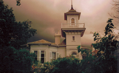 Kew Historical Society Inc
Photograph - 'Swinton', 23 Swinton Avenue, 2000
Swinton is of significance as one of the earliest examples of the use of the Italianate in Australian domestic architecture, and for the elegance of its design, particularly in the tower.Original colour positive photograph of the west elevation of Swinton, 23 Swinton Avenue, Kew. Facade facing Yarra River featuring tower and balcony with door and fanlight below. Projecting bay window at left. Rendered brick with slate roof. Ink on reverse: "Swinton - west elevation / Feb 2000"swinton, swinton avenue -- kew (vic.) -
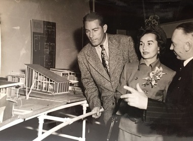 Kew Historical Society Inc
Photograph - Publicity Photograph, Herald Feature Service, Inspection of Architectural Models for a New Kew City Hall, circa 1959, 1959
The original Kew Town Hall offices were located in Walpole Street, Kew. Before 1960, even though it had been much discussed over a number of decades, Kew did not have a 'civic hall'. When required, events such as balls, exhibitions or theatrical events were held in the Kew Recreation Hall in Walpole Street. A new City Hall was to be opened by Sir Robert Menzies in 1960. It was located beside the Alexandra Gardens in Cotham Road. It is now used as the Kew Library. Cr Hugh George Ferguson (at right) was born in June 1900 in Williamstown. After his family moved to Kew, they lived in Fernhurst Grove while his future wife’s family lived in Fellows Street. He married in 1940 and subsequently joined the Australian Imperial Forces. After the war he worked as a Billeting Affairs Organiser for the Dutch Government, resettling migrants in Australia. He also worked in advertising as an account manager, and was campaign director for Arthur Rylah is Victorian politics. He organised the first major trade fairs at the Royal Exhibition Buildings after the Second World War, including a World Trade Fair. He built a home in Brougham Street and represented North Ward on Kew Council from 1952 to 1968. He was elected Mayor for the 1959-60 term. He died in 1975, aged 75, and is buried in Boroondara Cemetery.An item of historical interest donated by members of the Dods family in 2006. The Dods-Ferguson Collection includes a number of items once in the possession of the families related to or descended from two mayors of Kew: Cr. Hugh Ferguson and Cr. Frederick Dods.Publicity photograph of two men and a woman inspecting architectural models for a new Kew City Hall. The man at the right of the photograph is Cr Hugh George Ferguson, Mayor of Kew 1959-60. The Hall, now occupied by the Kew Library, was opened by The Hon H.E. Bolte MLA, Premier of Victoria in 1960.Herald Sun Feature Service / Hugh G. Ferguson & Associates / New Kew City Hall. kew city hall, hugh g. ferguson & asociates, architectural models - kew, cr hugh george ferguson -
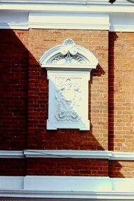 Kew Historical Society Inc
Slide - Decorative Element, Kew Court House, 1980
A civic campaign for new public offices developed in Kew in the 1880s. After much deliberation, the location chosen was the junction of Bulleen and Cotham Roads. The buildings were designed by George Watson and John Henry Harvey, architects within the Department of Public Works (Victoria). Building was commenced in 1887, and after one year, the buildings were opened. The Post Office was transferred to the new Commonwealth Government in 1901. The Police Station and Court House, sold by the Victorian Government to the City of Boroondara in 2007, are now a community cultural centre and performing arts venue.The buildings were listed on the Victorian Heritage Register Register (HO885) in 1991. They are historically and architecturally significant to the State of Victoria because Watson and Harvey's designs exhibit diversity in integrating civil offices, they accommodate the apex of road junctions, and they demonstrate a departure from the contemporaneously favoured High Victorian Classical to the Queen Anne style in the design of civic buildings. 35mm colour transparency of a painted decorative feature used at the Kew Court House on the corner of High Street and Cotham Road. The building is a significant example of the English Queen Anne Revival style. The photograph was taken as part of a series by Ralph Andrews (Department of Building, RMIT) in April 1980.kew post office, khs - slides, new public offices -- kew (vic.), architectural styles -- english queen anne revival -
 Kew Historical Society Inc
Photograph - 'Villa Alba', 44 Walmer Street, 1981
Villa Alba, a two-storeyed residence with rendered masonry walls and a slate roof, stands opposite Studley Park, overlooking the Yarra River. It is believed to have been first built before 1863, but substantially remodelled and enlarged in about 1882-83 for William Greenlaw, the Manager of the Colonial Bank of Australasia. Although the house and its tower must always have been a landmark in the area and the architecture is unusual, almost Norman in style, it is the interior which is the most remarkable feature of Villa Alba. (Source: VHD)Small black and white photographic positive of Vila Alba, 44 Walmer Street, Kew in 1981 when the original 1880s house was surrounded by hospital wards. The latter had been built by the Royal Women's Hospital after it acquired the site in 1950. The site wa Slater transferred to the Mount Royal Hospital before being purchased and converted into a museum of interior design.Verso: "Villa Alba 1981"villa alba -- 44 walmer street -- kew (vic.), mount royal hospital, henry pride wing -
 Kew Historical Society Inc
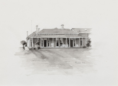
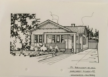
Drawing - Property Illustration, Margaret Picken, 191 Brougham Street, Kew, 1997
After training as a Cartographic Draftsman within the mining industry, I worked as a property illustrator for real estate firms in the eastern suburbs of Melbourne for 23 years from 1983. I initially photographed houses with a Polaroid camera and made a 'thumbnail' sketch while there. The photos were used to scale off a sketch in pencil and then that sketch was overlaid with drafting film and the 'pen and ink' completed. The pens I used were the Rotring ‘Rapidigraph’ drafting pens. The ink was also made by Rotring (German).The film was ‘Rapidraw’, polyester drafting film, double matte. It takes a very fine line and doesn’t bleed. As well as house sketches, there were often floor plans and site plans ordered. Aerial sketches were ordered when the property needed an overall view. (Margaret Picken, 2020)This drawing is one of a series created by Margaret Picken for a range of real estate agents in Melbourne between c.1983 and c.2005. Each work is signed and dated by the artist.Gift of Margaret Picken, 2020A 1920s weatherboard bungalow, now featuring a subsequent second floor addition. The pen and ink drawing on drafting film of 191 Brougham Street was made by Margaret Picken in 1997, and predates this addition.191 BROUGHAM ST., KEW / MARGARET PICKEN '97 / WOODARDS ~ HAWTHORNartist -- margaret picken 1950-, architectural drawings -- houses -- kew (vic.), 191 brougham street -- kew (vic.) -
 Kew Historical Society Inc
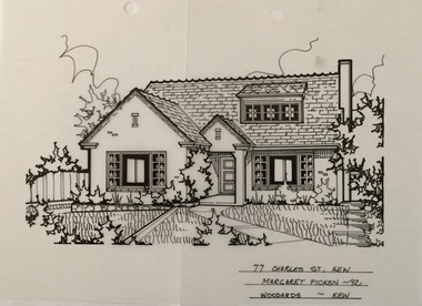
Drawing - Property Illustration, Margaret Picken, 77 Charles Street, Kew, 1992
After training as a Cartographic Draftsman within the mining industry, I worked as a property illustrator for real estate firms in the eastern suburbs of Melbourne for 23 years from 1983. I initially photographed houses with a Polaroid camera and made a 'thumbnail' sketch while there. The photos were used to scale off a sketch in pencil and then that sketch was overlaid with drafting film and the 'pen and ink' completed. The pens I used were the Rotring ‘Rapidigraph’ drafting pens. The ink was also made by Rotring (German).The film was ‘Rapidraw’, polyester drafting film, double matte. It takes a very fine line and doesn’t bleed. As well as house sketches, there were often floor plans and site plans ordered. Aerial sketches were ordered when the property needed an overall view. (Margaret Picken, 2020)This drawing is one of a series created by Margaret Picken for a range of real estate agents in Melbourne between c.1983 and c.2005. Each work is signed and dated by the artist.Gift of Margaret Picken, 2020Extant (2020) mixed cream brick house built in 1940 in the Old English style featuring a steep tiled roof. A dormer window was added at the front in 1957. Additions and alterations in 2000 included windows altered on the facade. The pen and ink architectural drawing on drafting film of 77 Charles Street, Kew by was completed in 1992 by Margaret Picken, and predates the alterations to the front windows.77 CHARLES ST., KEW / MARGARET PICKEN ~92 / WOODARDS ~ KEWartist -- margaret picken 1950-, architectural drawings -- houses -- kew (vic.), 77 charles street -- kew (vic.) -
 Surrey Hills Historical Society Collection
Compact disc, Melbourne Directory 1884 (Sands & McDougall)
The Sands and McDougall directories are amongst the most comprehensive. You can find out more details about places in which people lived, the other residents in the area, the services available in the region...all of which help to paint a picture of your ancestors' life. Apart from the Street, Alphabetical, Trade and Professional directories, this volume also contains Government and Official, Ecclesiastical, Legal, Municipal, Colonial, Societies and Institutions directories. A fascinating feature in this volume is a Universal Building Societies Supplement which includes 15 pages of architectural house plans of the day - layouts and elevations - with the house price for each.The Sands and McDougall directories are amongst the most comprehensive. You can find out more details about places in which people lived, the other residents in the area, the services available in the region...all of which help to paint a picture of your ancestors' life. Apart from the Street,Alphabetical, Trade and Professional directories, this volume also contains Government and Official, Ecclesiastical, Legal, Municipal, Colonial, Societies and Institutions directories. A fascinating feature in this volume is a Universal Building Societies Supplement which includes 15 pages of architectural house plans of the day- layouts and elevations- with the house price for each.streets, trade, agriculture, government, legal, ecclesiastical, farmers, farm workers, clergy, plans, timber houses, brick dwellings, buildings, structures and establishments -
 City of Greater Bendigo - Civic Collection
Ceremonial object - Eaglehawk Bell, unknown
The Borough of Eaglehawk was a local government area which covered the northwestern suburbs of the regional city of Bendigo and covered an area of 14.54 square kilometres (5.6 sq mi). Eaglehawk was first incorporated as a borough on 29 July 1862. It had nine councillors, who represented the entire borough. Councillors met at the Town Hall (incorporating the Star Cinema) at the intersection of Sailors Gully Road and Loddon Valley Highway, Eaglehawk. The Town hall has always been the centre of the Borough's activities and was built in 1901 on the site of an earlier town hall which had stood on the location since 1865. The Victorian Heritage Database notes: "The present building replaced this earlier building and was opened on 14 August 1901. The architects were the Melbourne firm of Wilkinson and Permewan. As a much larger and more sumptuous building of brick and stone featuring a central clock tower, the new hall reflected prevailing architectural fashion and was a remarkable investment for a town consisting predominantly of poor mining families. The condition of the town hall is substantially as built. The design is almost identical to the Castlemaine Town Hall." On 7 April 1994, the Borough of Eaglehawk was abolished, and along with the City of Bendigo, the Rural City of Marong and the Shires of Huntly and Strathfieldsaye, was merged into the newly created City of Greater Bendigo.Brass bell with eaglehawk topper / handle on timber stand. The lower front section of the topper has the Borough of Eaglehawk seal attached. No hallmarks or makers stamps visible.borough of eaglehawk, star cinema -
 Melton City Libraries
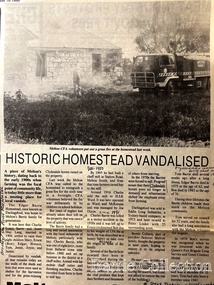
Newspaper, Historic Homestead Vandalised, 1990
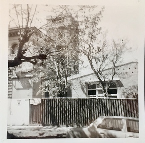
Edna Barrie describes the Darlingsford property. C.E. Barrrie Land developers bought the property from my husband’s brother. It was one big farm and they were a big family. When the father died he left it to be cut up for the family. The youngest son had to reach age 21 before the property could be divided and portioned out to the mother and children, but it was deferred until Jim returned from the war. Eventually it was cut up into two parts, we were married by then and so was Edgar. Part of the land included the block on the other side of Ferris road, which became the quarry, Edgar’s section was on the Toolern Creek end, he was the last one married and lived in the old bluestone house until 1974. The developers bought this section but they could not get permits due to the state of the old bridge due to the cost. Barries had built the bridge across the creek [1926]. It took the big loads of hay and the family kept it maintained. Once the Barries had gone it did not get any upkeep. The developers found the cost of replacing the bridge and developing site with sewerage and drainage power before they sell. The rural land itself is not worth much as the developer has to complete the subdivision before any blocks can be sold. The developer from Sydney had a man living in the house, who let it go the rack and ruin. He managed to buy from the developer 25 acres with the bluestone house. Bernard Coburn had it for a while but is was well out of our hands by then. There were various people who have bought into and tried to develop and have given up. There was a project sometime ago to save the buildings from ruin but nothing has happened as yet, they are six or seven years to late. The buildings continue to deteriorate and were badly damaged vandals and fire. The Shire bought all the rest of it from the developer, where the tip is now, that was also part of Edgars land. Article about a fire at Darlingsford Estate featured in the Telegraphlocal architecture, local identities, emergency services -
 Melton City Libraries
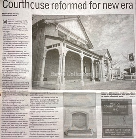
Newspaper, Courthouse reformed for new era, 2004
History of Melton Court house article featured in the Melton and Moorabool Leader local architecture -
 Melton City Libraries
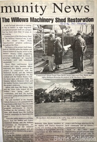
Newspaper, The Willows Machinery Shed Restoration, 1996
Machinery Shed Establishment. Involved with Jeff Robinson in the construction and collection of machinery display Restoration of the Willows shed article featured in the Express/Telegraph local identities, local special interest groups, local architecture -
 Melton City Libraries
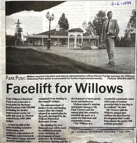
Newspaper, Facelift for the Willows, 1999
Works being undertaken at the Willows Homestead article featured in the Express Telegraph local architecture, council, local special interest groups -
 Melton City Libraries
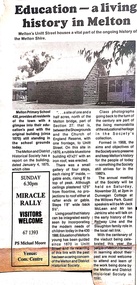
Newspaper, Education- a living history in Melton, 1986
History of Melton State School 430 article featured in the Telegrapheducation, local architecture -
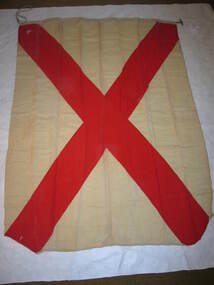 Parks Victoria - Cape Nelson Lightstation
Functional object - Flag set, navigational
The flags were used for communicating messages to passing ships. Knowledge of visual signaling was mandatory for all lightkeepers and all stations maintained a set of these flags. Although used for centuries, visual flag signaling formally developed in the nineteenth century and was published internationally as a system in 1857. By the early twentieth century it had developed into an effective means of conveying all kinds of short range visual messages.The Cape Nelson Lightstation is architecturally and scientifically (technologically) important as the most intact complex of lightstation buildings in Victoria. The octagonal signal station is a unique feature which is all the more important for its complete set of signal flags’. Cape Nelson Lightstation’s complete set of 41 alphabetic and numeric visual signaling flags (including substitute and answering pennants) are made of bunting, a coarse fabric of worsted (open yarn wool) in various colour combinations, and some of the fabric is hand sewn and bears inscriptions. Attachments include handmade wooden toggles, brass clips and hemp rope.