Showing 570 items
matching boundary road
-
 Ringwood and District Historical Society
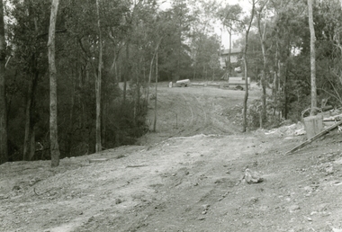
Photographs, 1979-80 MMBW pipe line project at Hubbard Reserve, North Ringwood � Looking east near Debbie Place
Part of a 43-photo record of the MMBW�s engineering feat in drilling a 12 inch pipe line up to 40 feet deep through rock hardened by volcanic action associated with geological fault that occurs along the line. The work took place from October 1979 to May 1980 on the southern boundary of Hubbard Reserve, North Ringwood. The collection was presented to the Ringwood Historical Research Group by J Clarke on 9th June 1980.E567 N16 13 May 1980 A43 Looking east from the ridge above Debbie Place. The finished manhole is in the gully. -
 Ringwood and District Historical Society
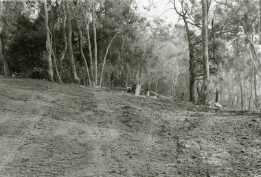
Photographs, 1979-80 MMBW pipe line project at Hubbard Reserve, North Ringwood � View east from Debbie Place
Part of a 43-photo record of the MMBW�s engineering feat in drilling a 12 inch pipe line up to 40 feet deep through rock hardened by volcanic action associated with geological fault that occurs along the line. The work took place from October 1979 to May 1980 on the southern boundary of Hubbard Reserve, North Ringwood. The collection was presented to the Ringwood Historical Research Group by J Clarke on 9th June 1980.E558 N29 13 May 1980 A43 View east from Debbie Place -
 Ringwood and District Historical Society
Photographs, 1979-80 MMBW pipe line project at Hubbard Reserve, North Ringwood � Track down to creek bridge
Part of a 43-photo record of the MMBW�s engineering feat in drilling a 12 inch pipe line up to 40 feet deep through rock hardened by volcanic action associated with geological fault that occurs along the line. The work took place from October 1979 to May 1980 on the southern boundary of Hubbard Reserve, North Ringwood. The collection was presented to the Ringwood Historical Research Group by J Clarke on 9th June 1980.E565 N12 13 May 1980 A43 My old track down to the bridge over the creek. The pipe line went to the right of the big tree 40-foot down. -
 Ringwood and District Historical Society
Photographs, 1979-80 MMBW pipe line project at Hubbard Reserve, North Ringwood � The new trach goes on down to Debbie Place
Part of a 43-photo record of the MMBW�s engineering feat in drilling a 12 inch pipe line up to 40 feet deep through rock hardened by volcanic action associated with geological fault that occurs along the line. The work took place from October 1979 to May 1980 on the southern boundary of Hubbard Reserve, North Ringwood. The collection was presented to the Ringwood Historical Research Group by J Clarke on 9th June 1980.E566 N13 13 May 1980 A43 The parting of the ways. My old track goes left to Burlock Avenue. The new way goes on down to Debbie Place. -
 Ringwood and District Historical Society
Photographs, 1979-80 MMBW pipe line project at Hubbard Reserve, North Ringwood � Manhole behind 29 Burlock Avenue
Part of a 43-photo record of the MMBW�s engineering feat in drilling a 12 inch pipe line up to 40 feet deep through rock hardened by volcanic action associated with geological fault that occurs along the line. The work took place from October 1979 to May 1980 on the southern boundary of Hubbard Reserve, North Ringwood. The collection was presented to the Ringwood Historical Research Group by J Clarke on 9th June 1980.E566 N5 13 May 1980 A43 Manhole behind 29 Burlock Avenue, 38 feet deep. Debbie place is on the far right. -
 Ringwood and District Historical Society
Photographs, 1979-80 MMBW pipe line project at Hubbard Reserve, North Ringwood � The manhole in the creek
Part of a 43-photo record of the MMBW�s engineering feat in drilling a 12 inch pipe line up to 40 feet deep through rock hardened by volcanic action associated with geological fault that occurs along the line. The work took place from October 1979 to May 1980 on the southern boundary of Hubbard Reserve, North Ringwood. The collection was presented to the Ringwood Historical Research Group by J Clarke on 9th June 1980.E563 1 April 1980 A43 The manhole in the creek, waiting until boring is finished. -
 Ringwood and District Historical Society
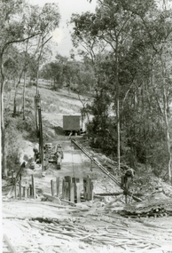
Photographs, 1979-80 MMBW pipe line project at Hubbard Reserve, North Ringwood � Tracked drill rig
Part of a 43-photo record of the MMBW�s engineering feat in drilling a 12 inch pipe line up to 40 feet deep through rock hardened by volcanic action associated with geological fault that occurs along the line. The work took place from October 1979 to May 1980 on the southern boundary of Hubbard Reserve, North Ringwood. The collection was presented to the Ringwood Historical Research Group by J Clarke on 9th June 1980.E561 N16 3 March 1980 A43 Tracked drill rig on the line of trench for sewer to Debbie Place -
 Ringwood and District Historical Society
Photographs, 1979-80 MMBW pipe line project at Hubbard Reserve, North Ringwood � Air track drill rig
Part of a 43-photo record of the MMBW�s engineering feat in drilling a 12 inch pipe line up to 40 feet deep through rock hardened by volcanic action associated with geological fault that occurs along the line. The work took place from October 1979 to May 1980 on the southern boundary of Hubbard Reserve, North Ringwood. The collection was presented to the Ringwood Historical Research Group by J Clarke on 9th June 1980.E561 N19 3 March 1980 A43 Air track drill rig in position as in N18 -
 Ringwood and District Historical Society
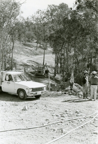
Photographs, 1979-80 MMBW pipe line project at Hubbard Reserve, North Ringwood � Last days of the boring
Part of a 43-photo record of the MMBW�s engineering feat in drilling a 12 inch pipe line up to 40 feet deep through rock hardened by volcanic action associated with geological fault that occurs along the line. The work took place from October 1979 to May 1980 on the southern boundary of Hubbard Reserve, North Ringwood. The collection was presented to the Ringwood Historical Research Group by J Clarke on 9th June 1980.E561 N1 1 April 1980 A43 Last days of the boring. The mole had broken between the last two shafts. Dominic Di Nezza and Glen Pearson discuss further moves to release it. -
 Ringwood and District Historical Society
Photographs, 1979-80 MMBW pipe line project at Hubbard Reserve, North Ringwood � Drill rig
Part of a 43-photo record of the MMBW�s engineering feat in drilling a 12 inch pipe line up to 40 feet deep through rock hardened by volcanic action associated with geological fault that occurs along the line. The work took place from October 1979 to May 1980 on the southern boundary of Hubbard Reserve, North Ringwood. The collection was presented to the Ringwood Historical Research Group by J Clarke on 9th June 1980.E561 N17 3 March 1980 A43 Powder-monkey marks out the spots for holes -
 Ringwood and District Historical Society
Photographs, 1979-80 MMBW pipe line project at Hubbard Reserve, North Ringwood � View towards Debbie Place
Part of a 43-photo record of the MMBW�s engineering feat in drilling a 12 inch pipe line up to 40 feet deep through rock hardened by volcanic action associated with geological fault that occurs along the line. The work took place from October 1979 to May 1980 on the southern boundary of Hubbard Reserve, North Ringwood. The collection was presented to the Ringwood Historical Research Group by J Clarke on 9th June 1980.E561 N15 3 March 1980 A43 View towards Debbie Place, showing 2 swivel cranes at shafts, timber of manhole in creek, the tracked drill rig and its compressor caravan. -
 Ringwood and District Historical Society
Photographs, 1979-80 MMBW pipe line project at Hubbard Reserve, North Ringwood � Boring mole pit
Part of a 43-photo record of the MMBW�s engineering feat in drilling a 12 inch pipe line up to 40 feet deep through rock hardened by volcanic action associated with geological fault that occurs along the line. The work took place from October 1979 to May 1980 on the southern boundary of Hubbard Reserve, North Ringwood. The collection was presented to the Ringwood Historical Research Group by J Clarke on 9th June 1980.E561 N14 3 March 1980 A43 View west behind No. 29 Burlock Avenue, showing gantry over manhole 38 feet deep. -
 Ringwood and District Historical Society
Photographs, 1979-80 MMBW pipe line project at Hubbard Reserve, North Ringwood � The work on sewer line from 29-39 Burlock Avenue
Part of a 43-photo record of the MMBW�s engineering feat in drilling a 12 inch pipe line up to 40 feet deep through rock hardened by volcanic action associated with geological fault that occurs along the line. The work took place from October 1979 to May 1980 on the southern boundary of Hubbard Reserve, North Ringwood. The collection was presented to the Ringwood Historical Research Group by J Clarke on 9th June 1980.E561 N11 3 March 1980 A43 The work on sewer line from 29-39 Burlock Avenue. Lundy-Clarke's place on sky-line. -
 Ringwood and District Historical Society
Photographs, 1979-80 MMBW pipe line project at Hubbard Reserve, North Ringwood � View from Debbie Place, preliminary sewer work
Part of a 43-photo record of the MMBW�s engineering feat in drilling a 12 inch pipe line up to 40 feet deep through rock hardened by volcanic action associated with geological fault that occurs along the line. The work took place from October 1979 to May 1980 on the southern boundary of Hubbard Reserve, North Ringwood. The collection was presented to the Ringwood Historical Research Group by J Clarke on 9th June 1980.E561 N13 28 Feb 1980 A43 View from Debbie Place, preliminary sewer work -
 Ringwood and District Historical Society
Photographs, 1979-80 MMBW pipe line project at Hubbard Reserve, North Ringwood � Line of tunnel shafts behind 29-39 Burlock Avenue
Part of a 43-photo record of the MMBW�s engineering feat in drilling a 12 inch pipe line up to 40 feet deep through rock hardened by volcanic action associated with geological fault that occurs along the line. The work took place from October 1979 to May 1980 on the southern boundary of Hubbard Reserve, North Ringwood. The collection was presented to the Ringwood Historical Research Group by J Clarke on 9th June 1980.E561 N10 Feb 1980 A43 Line of tunnel shafts behind 29-39 Burlock Avenue. Horizontal gantry was above the manhole in the corner of No. 29. -
 Ringwood and District Historical Society
Photographs, 1979-80 MMBW pipe line project at Hubbard Reserve, North Ringwood � First hole west of bore hole at 39 Burlock Avenue
Part of a 43-photo record of the MMBW�s engineering feat in drilling a 12 inch pipe line up to 40 feet deep through rock hardened by volcanic action associated with geological fault that occurs along the line. The work took place from October 1979 to May 1980 on the southern boundary of Hubbard Reserve, North Ringwood. The collection was presented to the Ringwood Historical Research Group by J Clarke on 9th June 1980.E561 N9 Feb 1980 A43 First hole west of bore hole at 39 Burlock Avenue -
 Ringwood and District Historical Society
Photograph, Images used for land sale promotion of Coleman's Heathmont Estate, looking across the estate from Canterbury Road, Heathmont towards Bedford Road on the far boundary. Sale 15/12/1923 by Public Auction
... towards Bedford Road on the far boundary. Sale 15/12/1923 by... Road Ringwood North melbourne Photograph Images used for land ...Catalogue card reads, "Coleman's Heathmont Estate 1923. 15/12/1923. Looking across the estate from Canterbury Rd. Bedford Rd. is seen on the far boundary." -
 Orbost & District Historical Society
photograph, 1893 - 1900
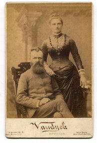
There is no information with this item. In the Bairnsdale Advertiser and Tamboon and Omeo Chronicle on Thursday August 3 1893, there is mention of a letter from Mr Harry Roberts, Marlo Road, "offering to sell the corduroy road to the council for £10, on condition that the council arranges for the exchange of the old road for one on the nothern boundary of his property.-Application to be made to the Lands department for the necessary exchange of roads to carry this proposal into effect. From the secretary for Lands, asking the council to mark the roads required in the M'Colloch on the plan,-Attended" This is likely to be the man in the photograph. This photograph seems to be associated with a very early settler in the Orbost / Marlo area. It is also a pictorial record of dress in the late 19th century.A sepia portrait photograph of a bearded man wearing a high-buttoned coat seated on a chair with a woman standing beside him on the right. The woman is wearing a long gownwith a full skirt, low at the waist. The fitted bodice is tightly buttoned and has a lace panel. Her hair is in a bun. She appears to be wearing a wedding ring. The photograph has been taken inside a studio. The photograph is mounted on card.on back - hand-written - "Mr & Mrs H. Roberts My Best Friend" front under photograph - :Vandyck Studios 3 Bourke St E Melbourne next door Gen Post Office portrait-roberts -
 Cheese World Museum
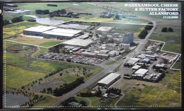
Photograph, Warrnambool Cheese and Butter Factory Co Ltd site 2000 -aerial view, 2000
Warrnambool Cheese and Butter Factory Company was formed by a group of Warrnambool business men. The company was registered in May 1888 and commenced commercial production in November 1888. The company retained its independence for more than 125 years until acquired by Canadian firm Saputo. It has operated from the same site since its inception and also has an office in Japan. Milk processing is undertaken by Sungold. Milk powder for export is also produced on-site. Cheese World is a retail arm of the company operates on a connected site selling company products, local food products, wine and cheese tasting. Cheese World Museum operates under the Cheese World umbrella.Aerial colour photograph of Warrnambool Cheese and Butter Factory in wooden frame. Shows buildings and surrounds. Lines indicate factory boundaries, dotted lines indicate property extension. Date is recorded on the image.17.10.2000allansford, warrnambool cheese and butter factory company, saputo, dairyiing, dairy manufacturing, diary manufacturers, cheese, butter -
 Ringwood and District Historical Society
Flyer, Land Sale Advertisement and auction notice - Range View Estate, Ringwood, Victoria - 1920
Advertisement for sale of 150 residential allotments with terms of sale, summary of local features and services, and map showing location and layout of subdivision within the boundary of Mitcham to the west of Ringwood, Victoria. Copy of newspaper advertisement (The Herald, Melbourne, Wednesday 3 March, 1920) refers to public auction date for Range View Estate Ringwood - Saturday, 27th March, 1920.Subdivision includes Deep Creek Road, Range View Grove, Warnes Road, Tarrangower Avenue, Prince Edward Avenue, James Avenue, and White Horse Road, Mitcham. Agents - Phillips & Nicholson, 281 Collins Street, Melbourne, Telephone Central 10907. -
 The Beechworth Burke Museum
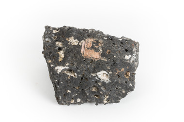
Geological specimen - Basalt, Unknown
Basalt is a common igneous rock that composes most of the Earth's surface and can be found on the Moon and other rocky planets of the Solar System. It is generally composed minerals such as calcic plagioclase, clinopyroxene and iron ore which form grains that are indistinguishable to the naked eye. It can be dark grey or black in colouring and sometimes may contain holes left by gas bubbles. Most of the Earth's basalt was produced in environments such as oceanic divergent boundaries, oceanic hotspots, and mantle plumes and hotspots beneath continents. Basalt is commonly used in construction where it is crushed and used for multiple purposes such as concrete aggregate, road base, or railroad ballast. Thin slabs of basalt can also be cut and used for floor tiles, stone monuments, and building veneer. This particular specimen was excavated from Talbot in Victoria, which was a small gold mining town established in 1852. As basalt is a common rock, it is not specific to Talbot. However, this specimen can be assumed to be of the Cainozoic age due to previous geomorphic surveys of the area. This particular type of Basalt was used mainly for roads due to the durability of the rock.Basalt holds significance due to the continued use of the rock from historic until present times. The rock has been utilised for many types of construction and is still used for the same purposes today. Basalt also has significance to the Earth and other rocky planets of the Solar System as it makes up most of the planet's surface. This specimen is part of a larger collection of geological and mineral specimens collected from around Australia (and some parts of the world) and donated to the Burke Museum between 1868-1880. A large percentage of these specimens were collected in Victoria as part of the Geological Survey of Victoria that begun in 1852 (in response to the Gold Rush) to study and map the geology of Victoria. Collecting geological specimens was an important part of mapping and understanding the scientific makeup of the earth. Many of these specimens were sent to research and collecting organisations across Australia, including the Burke Museum, to educate and encourage further study.A smaller than hand sized rock specimen which is dark grey in colour with small holes and white deposits across its surface.Geological survey / [illegible] /burke museum, beechworth, geological specimen, geology, basalt, basalt specemin, indigo shire, talbot, cainozoic, igneous rock -
 Warrnambool and District Historical Society Inc.
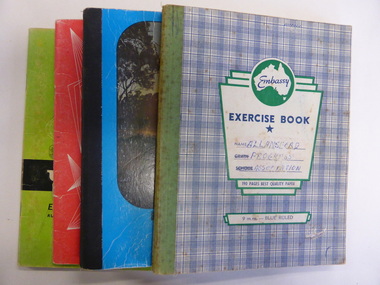
Booklet, Allansford Progress Association, Second half of 20th century
These four exercise books give documentation on the activities of the Allansford Progress Association (1966 to 1988). Allansford is a settlement about 9 kilometres from Warrnambool and most of the town area is now within the boundaries of the Warrnambool City Council. The association was re-formed in November 1966 after the demise of an earlier group. The members of the group campaigned in areas of local concern – T. V. reception, drainage and sewerage, postal services, sports facilities including the development of the Speedway, housing development, road proposals, waste management and disaster plans. These books are of interest in that they provide an overview of the history of a local organization. They will be useful for research. These are four exercise books - three Minutes books, and one Accounts book, from the Allansford Progress Association (1966-1988). The exercise books have coloured covers, (blue and white checkered, green, red and blue). Two are bound with tape and two are stapled. There are some loose sheets in all of the books. All the entries are handwritten. On front covers: ‘Allansford Progress Association’allansford progress association, history of allansford, history of warrnambool -
 Warrnambool RSL Sub Branch
MAP TO ACCOMPANY HEAVY ARTILLERY SCHEME FOR MOBILE WARFARE".....marked with 'Lanes' and Corps/Division Boundaries, Ordnance Survey, 1:40,000, France. Sheet 62c, Dec 1917. (centring on Peronne and Mont St Quentin), December 1917
Shows detail of Artillery Planning in the area of Peronne & Mont St Quentin. Inscribed "Map to accompany H.A. Scheme for Mobile Warfare". Marked with 'Lanes' and Corps/Division Boundaries.The donor, Staff Sergeant R.O. (Bob) Snape, Reg No 8651, enlisted as a Stretcher Bearer in 1915 but, because of his secretarial skills was employed in HQ positions as soon as he arrived in France and as a stenographer who worked as Confidential Clerk to General Sir John Monash from June to December 1918; and subsequently, for General Sir Talbot Hobbs until June 1919. The map was very likely directly used in the planning of the 1918 battles such as Mont St Quentin.Original Item recovered from possibly Australian Corps HQ, probably between the Armistice, 11 November 1918, and June 1919, when Staff Sergeant R.O.(Bob) Snape was repatriated. Shows detail of Artillery Planning in the area of Peronne & Mont St Quentin. Inscribed "Map to accompany H.A. Scheme for Mobile Warfare". Marked with 'Lanes' and Corps/Division Boundaries.snape collection -
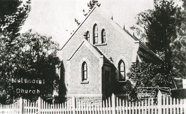 Eltham District Historical Society Inc
Photograph, Tom Prior, Methodist Church, Eltham
Situated at 810 Main Road on the corner of John Street. The Church was surrounded by a picket fence and tall pine trees. The Church was built by George Stebbings in the 1850s and is an example of fine craftmanship. Formerly Wesleyan, Methodist then Uniting church; the foundations of the church building were constructed with stone from the walls of the first Eltham State Primary School (No. 209) building which collapsed in 1874 and were purchased by Robert David Taylor. The Reynolds/Prior Photograph Collection, Presented to the Eltham District Historical Society, 14 June 2006 by Ross McDonald. A second copy was also presented to the Andrew Ross Museum, Kangaroo Ground The Reynolds family were early settlers in Research. Reynolds Road is named after this family. RERVISED STATEMENT OF SIGNIFICANCE, CONTEXT, 2010 What is significant? The 1880 bichromatic brick church and the surrounding site to the title boundaries. The church is architecturally, historically, socially and spiritually significant to the Shire of Nillumbik. Why is it significant? The church is architecturally significant as a finely detailed example of a brick 19th century rural community church, one of only four in the Shire (Criteria E & B). The church is historically significant as an important link with the time when Eltham was a small, insular country settlement. Also for the historical evolution visible in the complex, with the modest 1880s church and larger red brick rear hall from the early 20th century as a reflection of population growth in the area (Criterion A). The church is historically, spiritually and socially significant because it has played, and continues to play, an important part in the spiritual and social life of the community (Criterion G). - Victorian Heritage Database The Reynolds family were early settlers in Research. The Reynolds/ Prior collection of photographs were taken by Tom Prior, the maternal uncle of Ivy Reynolds, around 1900 and the 60 photos in the album give a fine overview of many of the landmarks of Research and Eltham over 100 years ago. lvy lived in the family home for many years at 106 Thompson Cres Research. Ivy's father, Ernst Richard Reynolds and grandfather, Richard Reynolds, lived at the same address. Ivy's father Richard worked for Mr. Trail on his property in Research. Reynolds Road is named after the family. Mr Tom Prior (wife Eva) worked at the Melbourne zoo. He was very innovative and made his own camera, using the black cloth hood to exclude the light. The photographs are a reminder of the rural nature of Research and Eltham and its rich heritage. Black and white photograph mounted in an album, the Reynolds/Prior Photograph Collection, this being one of 53 reproduced black and white images of early Eltham."Methodist Church" reynolds prior collection, eltham, methodist church -
 Eltham District Historical Society Inc
Book, Melway Publishing, Melway Greater Melbourne street directory : including Geelong, Phillip Island, Healesville, Bellarine & Mornington Peninsulas, 2002
Edition 29. Coloured detailed maps accessed by a street or location index. Cover: 20 additional pages of new maps, extended coverage of Bellarine Peninsula, further coverage of Werribee South, Public Transport Information, latest official suburb boundaries, CBD "hook turn" intersections map, over 1200 new streets, 1 atlas (24, 886 p.) : col. maps ; ISSN 03113957streets, roads, melbourne, maps, melway -
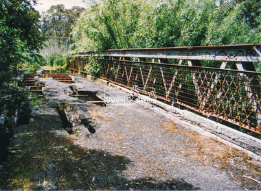 Eltham District Historical Society Inc
Photograph, Doug Orford, Lower Plenty Bridge, Old Eltham Road, Lower Plenty, 1998
Originally the boundary between the former Shire of Eltham and the City of Heidelberg, a toll gate existed on the Eltham side. The bridge has since been restored and is now part of the Plenty River Trail.Two colour photograph prints 10 x 15 cm (2 copies)bridges, lower plenty, main road, plenty river, old eltham road -
 Eltham District Historical Society Inc
Photograph, Monash Bridge, Arthurs Creek Road, Hurstbridge, Eltham Heritage Tour, 24 May 1992, 24/05/1992
ELTHAM HERITAGE TOUR The Society excursion on 24th May 1992 was arranged by David Bick, leader of the team carrying out the Shire's heritage study. David selected a number of sites or buildings identified in the study, some of them lesser known components of the Shire's heritage. The tour commenced at the Eltham Shire Office at 10.00 am. Travel was by private car and mini-bus with stops at about twelve locations for commentary by David.It included a short walk in Hurstbridge and lunch at Kinglake. Highlights of the tour included: - 10 am Leave from Shire Offices - 3 Important Trees - A Physical Link to Eltham's First Settlers - Toorak Mansion Gates - A Surviving Farm House - An Intact Circa 1900 Main Street - First Settlers - Gold Miners, and Timber-getters - An Early Hotel - A Pioneering Homestead - Changing Eltham Shire - 20th Century - 4 pm Afternoon Tea and Finish Tour Extract from ELTHAM CULTURAL HERITAGE TOUR (Newsletter No. 85, July 1992, by Bettina Woodburn) "On the Arthurs Creek Road is a bridge designed by Monash, which we admired before walking across the little park with a mud-brick and timber shelter, to the Hurst family graveyard. There are two marked graves, one, Henry who was shot by Burke the bushranger and a cairn has a plaque listing others buried here from 1866 onwards. Burke was captured and tied to the wheel of a dray under the eucalypt near the waterhose/standpipe. Close by the kindergarten, at this place are three trees on the National Trust Register, a Canary Island pine, a Canadian cedar and probably a spruce. Radiata pines and a thick bolled peppercorn surround the little cemetery. Continuing along Main Street we notice elm trees planted as a war memorial, then on the left a 1930 timber house, a 1910 store and residence, resplendent with wrought iron trim, a double fronted Hardware Store and cypresses on the back alignment of a new vacant block. On the right side of the street is a less interesting attempt at an 'in character' shop. Further on are more early homes, one tucked away at the rear with two tall palms by the front steps. Another curiosity is a rounded veranda corner and there are more galvanised iron sheds or garages, before a mud-brick Dentist's Surgery. Beyond the round-a-about is St Peters Church, of mud-brick construction shared by Catholic and Anglican parishioners, overlooking the river flood plain. Leaving Hurstbridge on the Kinglake Road, we ate our picnic lunch beside the communication tower and enjoyed views of Melbourne, Yan Yean Reservoir and the distant Dandenongs beyond the spreading suburbs. Next we drove to the North West boundary of the Shire at Masons Falls Road towards Whittlesea. On the way to the North East Boundary we passed St Peters, a yellow wooden Church with a Tudor Archway; built in the early 1920's in the style of the 1860's. From the Healesville-Kinglake road the rolling hills had European aspects, the hedged fields and chestnut trees. Then it was back down the Hurstbridge Road through 'Aussie' bush of towering gums, with bracken and scrubby understorey, the Kinglake National Park, before more open country with deciduous trees planted in line, and a creek lined with willows."Record of the Society's history and activities and highlighting various aspects of the Heritage Study undertaken by David Bick used to create the future heritage overlay for the Shire of Eltham and later Nillumbik Shire.Roll of 35mm colour negative film, 4 stripsKodak Gold 100 5095shire of eltham historical society, activities, heritage tour, hurstbridge, monash bridge, arthurs creek road -
 Warrnambool and District Historical Society Inc.
Documents, Late 20th, early 21st centuries
These ten documents (maps, plans, photographs) mostly come from the Warrnambool City Council and most contain information on sub-divisions and titles of properties in areas around the Central Business District of Warrnambool. The dates range from 1986 to 2006. These maps, plans and photographs are of some interest as they give historical details of subdivisions in Warrnambool and date from the late 20th century. .1 This is a laminated map of the boundaries of Local Governments in Victoria. It is Sheet I of 2 and has red and blue pencil markings and black boundary markings. .2 This is a copy of a plan of a survey in black and white markings on paper. .3 This is a plan of the title details of Section 19 Warrnambool. It has black printing on buff-coloured paper. .4 This is a plan of the allotments in part of the Central Business District of Warrnambool. It is printed in black and white. .5 This is a 2006 coloured aerial photograph of the harbour at Warrnambool – Breakwater etc. .6 This is a 2006 coloured aerial photograph of the Lake Pertobe area in Warrnambool .7 This is a coloured aerial photograph of Warrnambool’s streets over-stamped with road numbers in large blockings. .8 This is a plan showing the title details of Section 11 in Warrnambool. It has black printing on buff-coloured paper. .9.1 This is a plan of sub-divisions in parts of Crown Allotments 38 & 39 in Warrnambool. It has green, pink and yellow markings with black printing. .9.2 This is a plan of the sub-divisions in parts of Allotments 38 & 39 in Warrnambool. It has pink, yellow and blue markings with black printing. It is somewhat faded. warrnambool c.b.d. maps and plans, history of warrnambool -
 Kew Historical Society Inc
Archive (series) - Subject File, Barkers Road, 1953
Various PartiesReference, Research, InformationKHS OrderSubject file with multiple items of research relating to the history of Barkers Road, previously Barkers Track (sic) including: 2 copies of ‘Barkers Track: Recollections of the Hawthorn Kew Boundary’ (Typescript, Mervyn Chinner, undated, 4pp), ‘The Boroondara Family Hotel’ (Photocopied typescript, 1987, 10pp), ‘Barkers Road (Gwen McWilliam, 1976), a photocopy of an ADB entry on BARKER, Edward (1816-1885). The file also includes a typed letter to Mrs Dickins from Cr WHS Dickinson (1953) relating to the state of Barkers Road and sundry newspaper clippings/articles.barkers road - kew (vic.), barkers track - kew - hawthornbarkers road - kew (vic.), barkers track - kew - hawthorn -
 Sunshine and District Historical Society Incorporated
Map (1967), CITY OF SUNSHINE, June 1967, 1967
The City of Sunshine no longer exists. Part of the eastern area has been annexed by the City of Maribyrnong, and the rest of the old City of Sunshine has been amalgamated with the City of Keilor to form the larger City of Brimbank.This 1967 map is a historical record of the City of Sunshine as it existed 27 years before the amalgamation of Councils, and the creation of the City of Brimbank in 1994.Whitish paper map with black printing that is laminated in clear plastic film, and has a wood slat attached to the top edge. The June 1967 map is of the previous CITY OF SUNSHINE showing City and Parish boundaries, streets, railways, creeks, river etc.Purple ink stamps at top left hand and right hand areas showing address and contact details of 'Sunshine Industrial Promotion Centre.'city of sunshine, june 1967, map, city, parish, boundaries, brimbank