Showing 316 items
matching excavations
-
 Kiewa Valley Historical Society
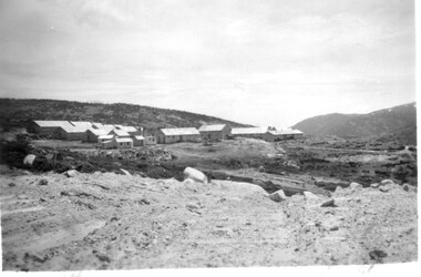
11 Black and White photographs of the Rocky Valley area, c1948
In October 1947 construction was commenced on the erection of the workmen's camp at Rocky Valley. Also in 1947 construction of a stream diversion was commenced to allow excavation to commence for the dam wall. In the summer of 1948/49, stripping of the foundation area on both sides of the river was carried out. Weather conditions were not always favourable during the construction, particularly 1955/56 summer, and work would have to cease each year for the winter season due to the severe conditions. The dam is a earth and rock fill structure with a height of about 30.5 metres and crest length 518.16 metres and was completed in March, 1959.These photographs show the type of terrain in the area prior to the construction and filling of Rocky Valley Dam. Also of interest is the type of accommodation provided for those working on the construction and the early cranes available in the 1940/50's. Of historical importance to understand the conditions in the early construction of the Kiewa Hydro Electric SchemeEleven small black and white photographsPhoto No. 1 - on the back, printed in ink"Rocky Valley - New Mess & offices Dec. 1948". In pencil '14 on the back Photo No. 2 - on the back, printed in ink "Rocky Valley Camp. October 1948". Also stamped on the back "998L" Photo No. 3 -on the back, printed in ink "Rocky Valley Hostel October 1948". Also stamped on the back '998L' Photo No. 4 - on the back, printed in ink "Spion Kopje from bedroom window. October 1948". Stamped on the back '998L'. Photo No. 5 - on the back, printed in ink "Rocky Valley Basin Dec. 1948." In pencil on back, 14. Photo No. 6 - on the back, printed in ink "Site of Wall for Rocky Valley Dam Dec. 1948". In pencil on back, 14. Photo No. 7 - On the back, printed in ink "Commencing of Diversion Tunnel Rocky Valley December 1948". In pencil on back, 14. Photo No. 8 - on the back, printed in ink "One of the two electric cranes at Rocky Valley December 1948". In pencil on back, 14. Photo No. 9 - on the back, printed in ink "'Rapier' (H.Y.) electric crane Rocky Valley December 1948". In pencil on back, 14 . Photo No. 10 - on the back, printed in ink " Pretty Valley Pump line construction Mt. Cope in Background Nov 1948. Circular stamp with the words 'print by Wilson White Albury' in the circle. Photo No. 11 - on the back, printed in ink "Stringing cable on Ruined Castle October 1948. Same stamp as No. 10. In pencil '31'. rocky valley; pretty valley; ruined castle; bogong high plains; kiewa hydro electric scheme -
 Kiewa Valley Historical Society
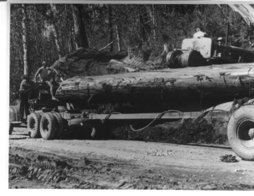
Photograph, logging at McKay Creek, Logging at McKay Creek, 1949/50
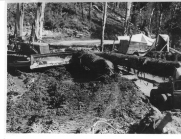
This photo was most likely taken at the site of the proposed McKay Creek Power Station. Excavation of this site was commenced in 1951 but an access road (a rough, narrow track) was put it in 1948 and widened in 1954. The State Electricity Commission would have milled logs from this area at their mill at Howman's Gap. The timber was used for building of housing and camps and provided a much needed resource as there was a general shortage of this commodity. The power station was relocated underground owing to repeated problems with landslides in the area. Restricted financial resources and the repositioning of the power station retarded construction activities and it was not completed until early 1961. An historical pictorial record of the type of machinery used in the 1950's - logging truck with bogie attached, the bull dozer and winch for hauling logs to the truck and note the lack of protective clothing!Black and white photograph showing a logging truck, bogie and bull dozer with winch for hauling the logs to the truck. Two men are on the truck, a driver on the bull dozer and a large log on the bogie. Hand written on the back of photo "Logging at McKay Creek".logging, mckay creek, timber, machinery -
 Eltham District Historical Society Inc
Photograph, Sherbourne Road, Para Road and Simms Road at Briar Hill, 3 November 1967, 3 Nov 1967
Viewed from Simms Road in front of Mrs Cameron's house in what is now the northwest bound lanes of Para Road prior to the roundabout intersedction with Sherbourne Road. Simms Road is running to the right in front of the old house. The house belongs to Mrs Cameron whose daughter married a DAVEY after which Davey Street is named. Excavation work is being undertaken for the realignment of the Para Road and Sherbourne Road intersection where the current roundabout is located, approximately where the two cars are parked. Mrs Cameron's house and the other are where Montmorency Secondary College is situated. The school opened in 1969.Roll of 35mm black and white negative film, 6 strips Ilford HP3briar hill, cameron, davey, davey road, graham body works, greensborough, montmorency secondary college, sherbourne road, simms road -
 Bendigo Historical Society Inc.
Photograph - WES HARRY COLLECTION: VIEW POINT, SANDHURST, 1861?, C. 1861
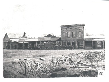
Photograph of a row of businesses in View Point Sandhurst. Depicted are .. H?. Joseph, Assay Office; Lunn's Furniture Warehouse; Victoria House; S.F.Bastard Draper; M. Langridge's View Point Hotel, and Williamson wholesale butcher. In front of the shops is a wagon load of timber, with a team of 5 horses and in the near foreground there are some excavations. The ground floor of the hotel appears to contain the following businesses - Imperial Fire Insurance Office, Gilles & Co. stock and sharebrokers. See Butcher & Collins book An American on the Goldfields. See Research field for further information.Batchelderplace, bendigo, view point, sandhurst, view point sandhurst. assay office. lunn's furniture warehouse. victoria house. s. f. bastard. m. langridge view point hotel. williamson wholesale butcher. -
 Melbourne Tram Museum
Document - Specification, City of Melbourne Tramways, "Hawthorn Horse Tram", 1880s
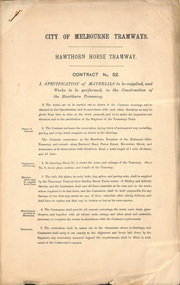
Contract No 52 - Specification of materials to be supplied, and works to be performed, in the construction of the Hawthorn Tramway. The contract embraces the excavation, laying down of permanent way, metalling, paving, and every detail complete as shown in the drawings. The contract commences at the Hawthorn Terminus of the Richmond Cable Tramway and extends along Burwood Road, Power Street, Riversdale Road and terminates at Glenferrie Road. Total length 1 mile, 52 chains and 25 links. Contract No 109 - as per above, except for termination at Auburn Road. Total length 67 chains and 50 links. .trams, tramways, horse trams, tenders, trackwork -
 Kiewa Valley Historical Society
Photograph Shovel Truck, Shovel Loading Rail Truck, circa 1950s
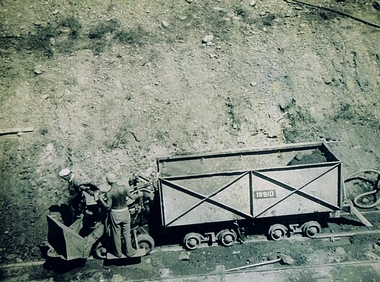
This item shows the excavation of the side of a railway track using a pneumatic shovel and a rail mounted truck by two workmen. The period covered was well before State Health and Safety requirements, such as helmets, became law. It also details that the workmen were from European heritage as their head coverings were a handkerchief knotted at each corner. This was typical for workmen of this heritage, others used caps or hats or no head covering at all (the macho male look)The photograph of this item was one of many depicting great achievements and opening up the region. A visual link or time capsule of the 1950s rural/mining sectors clashing with the established rural industriesThis photo depicts the time (1950's) and place (Bogong and Mount Beauty) where construction workers had an immense impact, not only on the physical environment but also on the social and economic development of the Victorian Alps region. The fast expansion of smaller settlements brought about increased pressures on the welfare viability of certain subgroups within the region e.g. farming, droving and commerce (caravan hawkers versus static shops). These changes brought about a heightened awareness by both local and State Governments to upgrade not only facilities within the region but also access to the region. Black and white photo of two workmen on a rail mounted shovel truck. The photo is of good definition allowing a clear view of the subject matter. The paper is semi gloss.On the back of the photo, paper suppliers etchings are "Kodak XtraLife II paper"mining, hydro electricity, victorian alps, construction camps, earth moving machines -
 Kiewa Valley Historical Society
Photograph, logging at McKay Creek, Logging at McKay Creek, c1950's
This photograph was probably taken at the site of McKay Creek Power Station. Excavation of this site did not commence until 1951 but road access(a narrow track) was provided in 1948 and widened in 1954. The logs would have been milled for timber at the State Electricity Commission's mill at Howman's Gap and thus provided a much needed source of timber for construction of camps and houses as there was a general of shortage of this commodity. Because of trouble with landslides in this area, a decision was made to place the machine hall of the power station underground instead of on the surface. Restricted financial resources and the repositioning of the power station retarded construction activities and it was not completed until early 1961.. An excellent pictorial record of the general working conditions, type of machinery and vehicles in use in the 1950/s.Black and white photograph showing logging equipment, fallen logs.Handwritten on the back of the photograph "Logging at McKay Creek)logging, mckay creek, timber, machinery -
 Ballarat Tramway Museum
Photograph - Bromide of a b/w photograph, Nov. 1974
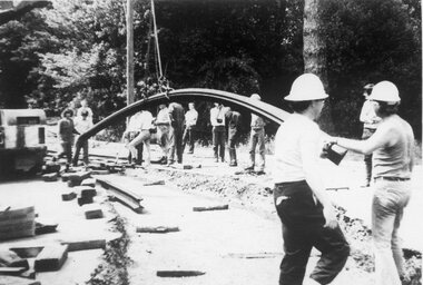
Has strong association with the event of laying the track across Wendouree Parade during Nov. 1975, an essential task to enable the re-opening of the tramway by the BTPS.Bromide of a black and white photograph of rails being laid to cross Wendouree Parade to access the new BTPS depot access track. Excavation done, first main curve rail being positioned using a crane. Date of photograph late November 1974. Depot Junction in background. BTPS Annual report states that site work began 22/11/1974. Photographer unknown. Bromide made c1994 for possible publication, but not used. See also Reg item 3506.1 and .2 for other photos on the same day. See 1974 - 1975 BTPS Annual Report page 4.trams, tramways, btps, wendouree parade, track laying, depot junction -
 Ballarat Tramway Museum
Photograph - Black & White Photograph/s - set of 2, Nov. 1974
Has strong association with the event of laying the track across Wendouree Parade during Nov. 1975, an essential task to enable the re-opening of the tramway by the BTPS.Black and white photograph of rails being laid to cross Wendouree Parade to access the new BTPS depot access track. Excavation done. Date of photographs late November 1974. Depot Junction in background. BTPS Annual report states that site work began 22/11/1974. Has date stamp of "8.1.75" on rear of photograph. .1 - prior to first main curve rail being positioned using a crane. .2 - after first curved rail laid - see also Reg Item 1633. See also Reg Item 1633 for another photograph on the same day.tramways, trams, btps, wendouree parade, track laying, depot junction -
 Ballarat Tramway Museum
Photograph - Colour Print/s - set of 10, Warren Doubleday, 13/09/2003 12:00:00 AM
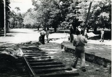
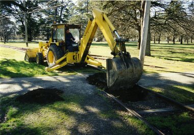
Set of ten colour photographs of the renewal of the sleepers under the level crossing on the main access line, BTM Depot, taken by Warren Doubleday on 13.09.2002. Printed on Agfa Paper. 2603.1 - Commencing excavations - Oedf Byslma on backhoe. 2603.2 - Exposing and pulling out sleepers. 2603.3 - offloading sleepers 2603.4 - inserting sleepers 2603.5 - ditto 2603.6 - Sleepers installed 2603.7 - view along inside rail 2603.8 - view along outside rail 2603.9 - Dog spiking - Alan Snowball, Greg Histen , Danny Smith, Richard Gilbert and Garry Wood, 2603.10 -ditto On rear of each photo in brown felt tip pen, the details of the location and date.btm, access track, trackwork -
 Bendigo Historical Society Inc.
Document - MARKS COLLECTION: ARCHITECTS AND CIVIL ENGINEERS CONDITIONS OF CONTRACT
2 blue printed pages outlining regulations of the VICTORIAN Institute of Architects plus 4 handwritten pages of specifications of stairs = turret as proposed to be erected in addition to Fortuna Villa Sandhurst, the residence of G. Lansell. Introductory comments in the specification state: 'The Contractors attention is hereby drawn to the fact - at the outset - that the whole work is to be composed of the very best materials as hereafter detailed, and to be done by the best workmen in the best manner'. Issues covered in the specification include excavation, removal of earth, schedule price for digging and stonework, pressed bricks, pugged mortar, joints, neck, dome roof (diagram of roof included) .bendigo, buildings, fortuna villa -
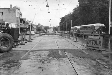 Melbourne Tram Museum
Photograph - Black & White Photograph/s, Melbourne & Metropolitan Tramways Board (MMTB), early 1955
Black and white photographs of the construction of the junction at Gertrude and Nicholson St c1955. On the right hand side of the photograph are two buses showing the Destination of Northcote. The former cable tram track in Nicholson St is yet to be removed - shows the offset between the tracks and the wood blocks. Possibly only the junction tracks have been completed at this time as there appears to be an excavation and a hut in the distance. There is a detour sign indicating that possibly vehicles used the completed section and that trackwork was underway for Gertrude St. The overhead has been erected. In the background is Osborne House. signs for The Age, The Sun and Peters Ice Cream. Early 1955?trams, tramways, trackwork, rails, track materials, track repairs, sleepers, equipment, cable trams, gertrude st, nicholson st, overhead -
 Warrnambool and District Historical Society Inc.
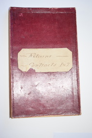
Administrative record - Warrnambool Water Trust Notebook, late 19th century (1892-1900)
This notebook appears to be the Warrnambool Water Trust Records of two contracts in 1892 . (The reference is written as 'W.W.Trust'.) The first contract, with the contractors, Coates and Reed, is for the excavation for settling tanks and clear water basin and a reservoir in Liebig Street and there are 60 pages giving details of these works - labour, masonry, concreting, fencing etc. The second contract with the contractor, William Kellas, is for the erection of a cottage and an engine shed and boiler room (7 pages). The Warrnambool Water Trust was set up in 1891 and the first project was the supply of water from the Merri River near Wollaston to a reservoir and tower in Liebig Street and this notebook concerns some details of this early water supply scheme. This notebook is of some interest as it supplies details of a late 19th century Warrnambool water supply scheme and so should be of value to local history researchers This is a notebook with a red leather cover and pages with printed headings and ruled red lines. The pages contain handwriting in black ink. The cover has a label (partly torn) with handwriting.Returns Contracts 1 & 2warrnambool water supply, warrnambool water board, 19th century water in warrnambool -
 The Beechworth Burke Museum
Photograph
Taken on 25 October 1930, various houses with the Hume Dam under construction are depicted in the background. The construction of the Hume Dam took place from 1919 to 1936. At the time of construction, it was the second largest dam in the world. It was also one of the earliest civil projects developed after the Federation. Some of the Dam workers consisted of World War I veterans. Dam workers often settled their families in Mitta Junction Village and Wodonga. Archaeological surveys were completed by Austral Archaeology, which was done when the Department of Land & Water Conservation was doing work to improve Hume Dam. The archaeological report that came out of the survey recommended three sites of interest where archaeological excavation should be done: Camp Ganger’s Quarters, Stableman’s Quarters, and the Industrial Dump. The excavation uncovered artefacts. Mitta Mitta: Mitta Mitta is situated between Mount Welcome and Mount Misery. It is named after the river that explorers Hume and Hovell discovered in 1824. The town would eventually become a huge gold mining town. Mitta Mitta is called Midamodunga by the local Indigenous peoples Wodonga: Wodonga is situated on the Murray River and is part of North East Victoria. Hume and Hovell: Hamilton Hume (1979-1873) and William Hilton Hovell (1786-1875). W. H. Hovell was born in Norfolk England and Hume was born in Parramatta, New South Wales Hovell and Hume undertook an exploration journey in 1824 and thought they discovered a river, which turned out to be the Murray River. They returned home in 1825, but returned to the area in 1826 and discovered coal in the area. This photo is historically significant as it shows the Hume Dam under construction in 1930. The Dam was named after Hamilton Hume, who is an important historical figure for this area as he helped discover the area where resources were found.Sepia rectangular photograph printed unmountedReverse: 84-19-5 / 1997.3185/ Values & spillway. / When completed the wall / will be as high as the / scaffolding. [featuring trademark: kodak print]construction, houses, veterans, mitta junction village, hume dam, world war i, federation, wodonga, archaeological survey, excavation, austral archaeology, department of land & water conservation, camp ganger's quarter's, stableman's quarters, industrial dump, artefacts, mitta mitta, mount welcome, mount misery, murray river, hamilton hume, william hilton hovell, hume and hovell expedition -
 The Beechworth Burke Museum
Photograph, c1930
Taken on 25 October 1930, various houses with the Hume Dam under construction are depicted in the background. The construction of the Hume Dam took place from 1919 to 1936. At the time of construction, it was the second largest dam in the world. It was also one of the earliest civil projects developed after the Federation. Some of the Dam workers consisted of World War I veterans. Dam workers often settled their families in Mitta Junction Village and Wodonga. Archaeological surveys were completed by Austral Archaeology, which was done when the Department of Land & Water Conservation was doing work to improve Hume Dam. The archaeological report that came out of the survey recommended three sites of interest where archaeological excavation should be done: Camp Ganger’s Quarters, Stableman’s Quarters, and the Industrial Dump. The excavation uncovered artefacts. Mitta Mitta: Mitta Mitta is situated between Mount Welcome and Mount Misery. It is named after the river that explorers Hume and Hovell discovered in 1824. The town would eventually become a huge gold mining town. Mitta Mitta is called Midamodunga by the local Indigenous peoples Wodonga: Wodonga is situated on the Murray River and is part of North East Victoria. Hume and Hovell: Hamilton Hume (1979-1873) and William Hilton Hovell (1786-1875). W. H. Hovell was born in Norfolk England and Hume was born in Parramatta, New South Wales Hovell and Hume undertook an exploration journey in 1824 and thought they discovered a river, which turned out to be the Murray River. They returned home in 1825, but returned to the area in 1826 and discovered coal in the area.This photo is historically significant as it shows the Hume Dam under construction in 1930. The Dam was named after Hamilton Hume, who is an important historical figure for this area as he helped discover the area where resources were found.Sepia rectangular photograph printed unmountedReverse: 84-19-2/ 1997.3188/ These are the four / release valves they are / not always open (illegible) this / when closed the water flows / over the spillway. [featuring trademark: kodak print] photograph number: 354construction, houses, veterans, mitta junction village, hume dam, world war i, federation, wodonga, archaeological survey, excavation, austral archaeology, department of land & water conservation, camp ganger's quarter's, stableman's quarters, industrial dump, artefacts, mitta mitta, mount welcome, mount misery, murray river, hamilton hume, william hilton hovell, hume and hovell expedition -
 The Beechworth Burke Museum
Photograph, 25 October 1930
Taken on 25 October 1930, various houses with the Hume Dam under construction are depicted in the background. The construction of the Hume Dam took place from 1919 to 1936. At the time of construction, it was the second largest dam in the world. It was also one of the earliest civil projects developed after the Federation. Some of the Dam workers consisted of World War I veterans. Dam workers often settled their families in Mitta Junction Village and Wodonga. Archaeological surveys were completed by Austral Archaeology, which was done when the Department of Land & Water Conservation was doing work to improve Hume Dam. The archaeological report that came out of the survey recommended three sites of interest where archaeological excavation should be done: Camp Ganger’s Quarters, Stableman’s Quarters, and the Industrial Dump. The excavation uncovered artefacts. Mitta Mitta: Mitta Mitta is situated between Mount Welcome and Mount Misery. It is named after the river that explorers Hume and Hovell discovered in 1824. The town would eventually become a huge gold mining town. Mitta Mitta is called Midamodunga by the local Indigenous peoples Wodonga: Wodonga is situated on the Murray River and is part of North East Victoria. Hume and Hovell: Hamilton Hume (1979-1873) and William Hilton Hovell (1786-1875). W. H. Hovell was born in Norfolk England and Hume was born in Parramatta, New South Wales Hovell and Hume undertook an exploration journey in 1824 and thought they discovered a river, which turned out to be the Murray River. They returned home in 1825, but returned to the area in 1826 and discovered coal in the area.This photo is historically significant as it shows the Hume Dam under construction in 1930. The Dam was named after Hamilton Hume, who is an important historical figure for this area as he helped discover the area where resources were found.Sepia rectangular photograph printed unmountedReverse: 84-19-6/ 1997.3187/ The spillway [featuring trademark: kodak print] construction, houses, veterans, mitta junction village, hume dam, world war i, federation, wodonga, archaeological survey, excavation, austral archaeology, department of land & water conservation, camp ganger's quarter's, stableman's quarters, industrial dump, artefacts, mitta mitta, mount welcome, mount misery, murray river, hamilton hume, william hilton hovell, hume and hovell expedition -
 The Beechworth Burke Museum
Photograph, 25 October 1930
Taken on 25 October 1930, various houses with the Hume Dam under construction are depicted in the background. The construction of the Hume Dam took place from 1919 to 1936. At the time of construction, it was the second largest dam in the world. It was also one of the earliest civil projects developed after the Federation. Some of the Dam workers consisted of World War I veterans. Dam workers often settled their families in Mitta Junction Village and Wodonga. Archaeological surveys were completed by Austral Archaeology, which was done when the Department of Land & Water Conservation was doing work to improve Hume Dam. The archaeological report that came out of the survey recommended three sites of interest where archaeological excavation should be done: Camp Ganger’s Quarters, Stableman’s Quarters, and the Industrial Dump. The excavation uncovered artefacts. Mitta Mitta: Mitta Mitta is situated between Mount Welcome and Mount Misery. It is named after the river that explorers Hume and Hovell discovered in 1824. The town would eventually become a huge gold mining town. Mitta Mitta is called Midamodunga by the local Indigenous peoples Wodonga: Wodonga is situated on the Murray River and is part of North East Victoria. Hume and Hovell: Hamilton Hume (1979-1873) and William Hilton Hovell (1786-1875). W. H. Hovell was born in Norfolk England and Hume was born in Parramatta, New South Wales Hovell and Hume undertook an exploration journey in 1824 and thought they discovered a river, which turned out to be the Murray River. They returned home in 1825, but returned to the area in 1826 and discovered coal in the area.This photo is historically significant as it shows the Hume Dam under construction in 1930. The Dam was named after Hamilton Hume, who is an important historical figure for this area as he helped discover the area where resources were found.Black and white rectangular photograph printer unmountedReverse: 84-20-1/ 1997.3147construction, houses, veterans, mitta junction village, hume dam, world war i, federation, wodonga, archaeological survey, excavation, austral archaeology, department of land & water conservation, camp ganger's quarter's, stableman's quarters, industrial dump, artefacts, mitta mitta, mount welcome, mount misery, murray river, hamilton hume, william hilton hovell, hume and hovell expedition -
 The Beechworth Burke Museum
Photograph, 25 October 1930
Taken on 25 October 1930, various houses with the Hume Dam under construction are depicted in the background. The construction of the Hume Dam took place from 1919 to 1936. At the time of construction, it was the second largest dam in the world. It was also one of the earliest civil projects developed after the Federation. Some of the Dam workers consisted of World War I veterans. Dam workers often settled their families in Mitta Junction Village and Wodonga. Archaeological surveys were completed by Austral Archaeology, which was done when the Department of Land & Water Conservation was doing work to improve Hume Dam. The archaeological report that came out of the survey recommended three sites of interest where archaeological excavation should be done: Camp Ganger’s Quarters, Stableman’s Quarters, and the Industrial Dump. The excavation uncovered artefacts. Mitta Mitta: Mitta Mitta is situated between Mount Welcome and Mount Misery. It is named after the river that explorers Hume and Hovell discovered in 1824. The town would eventually become a huge gold mining town. Mitta Mitta is called Midamodunga by the local Indigenous peoples Wodonga: Wodonga is situated on the Murray River and is part of North East Victoria. Hume and Hovell: Hamilton Hume (1979-1873) and William Hilton Hovell (1786-1875). W. H. Hovell was born in Norfolk England and Hume was born in Parramatta, New South Wales Hovell and Hume undertook an exploration journey in 1824 and thought they discovered a river, which turned out to be the Murray River. They returned home in 1825, but returned to the area in 1826 and discovered coal in the area. This photo is historically significant as it shows the Hume Dam under construction in 1930. The Dam was named after Hamilton Hume, who is an important historical figure for this area as he helped discover the area where resources were found. Black and white rectangular photograph printer unmountedReverse: 1997.3145/ 84-20-2construction, houses, veterans, mitta junction village, hume dam, world war i, federation, wodonga, archaeological survey, excavation, austral archaeology, department of land & water conservation, camp ganger's quarter's, stableman's quarters, industrial dump, artefacts, mitta mitta, mount welcome, mount misery, murray river, hamilton hume, william hilton hovell, hume and hovell expedition -
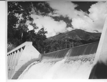 Kiewa Valley Historical Society
Photograph of Lake Guy Dam, Spillway, Lake Guy Dam, c1945
In December 1939 the excavation of the diversion tunnel at the site of Junction (Lake Guy) Dam was commenced and finished in February, 1940.This allowed the stream to be diverted to facilitate the dam wall construction. This is a 'slab and buttress' dam. It is framed with timber and concrete then poured into the structure. A contract was let to Lewis Construction Co. for the construction of the dam, and the first batch of concrete was placed in September, 1940. Industrial trouble caused some delays but there was also slow progress on the part of the contractor and the work was taken over by the S.E.C., terminating the contract. The dam was completed in March, 1944. The lake is named after Mr. L.T. Guy who was the Resident Engineer, in charge of construction work and associated activities on the Kiewa area, from 1939 until November 1946. An historical pictorial record taken for the State Electricity Commission of Junction Dam (Lake Guy) on spill. Mt. Arthur is in the background and there is still evidence of the destruction of trees from the 1939 bushfires. Black and white photograph of Lake Guy Dam . The dam is spilling and Mt. Arthur is in the background. Hand written on back of photograph in blue ink " Lake Guy Dam".dam, lake, water, mr. l.t.guy -
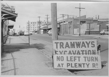 Melbourne Tram Museum
Photograph - Tramway excavation signage at Bell St and Plenty Rd, Preston, c1960s
Photograph shows Bell St, Preston looking eastward toward Plenty Rd with the newly constructed (1958-60) Preston and Northcote Community Hospital in the background. Signage in the foreground reads 'Tramway Excavation - No left turn at Plenty Rd' which may indicate works outside the East Preston tram depot (opened 1955) located in Plenty Rd less than 100 metres north of Bell St. In the mid-ground, several passengers wearing coats wait for a Bell St bus and numerous motor cars are shown on this narrow stretch of Bell St that would not be widened until the 1970s. While no note is attached, the model of motor cars suggest a date in the 1960s.Yields information about Bell St preston in 1960s Black and white photograph stuck to thick boardm&mtb, bell st, preston, plenty rd, tramway signage, preston and northcote community hospital, bell st widening -
 Wodonga & District Historical Society Inc
Album - Hume Reservoir Australia Album - Excavations for foundations inside coffer dam, January 1927
This set of photos is from a leather bound album bearing the inscription "HUME RESERVOIR AUSTRALIA" plus 'The Rt. Hon. L. C. M. S. Amery, P. C., M .P.' all inscribed in gold. It was presented to The Rt. Hon. L. C. M. S. Amery, P. C., M. P, Secretary of State for Dominion Affairs on the occasion of his visit to the Hume Reservoir on 2nd November 1927. This album is of local and national significance as it documents the planning and development of the Hume Reservoir up to 1927. It was the largest water reservoir in the British Empire. The album records the pioneering engineering work that went into its construction.DEPARTMENT OF PUBLIC WORKS, N.S.W. RIVER MURRAY WATERS SCHEME. HUME RESERVOIR. 21. Excavations for foundations inside coffer dam. New South Wales. January 1927. Cofferdams are temporary structures used where construction is being carried out in areas submerged in water. They are most commonly used to facilitate the construction or repair of dams, piers and bridges. To divert the river, a Coffer Dam was built across the old bed above and below the Dam site and tying into the end of the concrete wall built inside the levee bank. This completely surrounded the remainder of the site of the Dam and south wing wall, including an area of 12½ acres. hume reservoir australia, river murray waters scheme, hume reservoir construction, coffer dam -
 The Beechworth Burke Museum
Photograph
This image shows an unknown location in the area of Beechworth that was possibly used as a sluicing mining site for gold during the Victorian Gold Rush. This era saw an influx of Chinese immigrants and Australian prospectors hoping to strike it rich on the fields. Many companies such as the Rocky Mountain Extended Gold Sluicing Company Ltd and the Cocks Pioneer Gold &Tin Sluicing Company also set up mines in the area. This site may be the location of one of these company's mines. The wooden logs are reminiscent of known sluicing operations in the era from that time. Sluicing involved the use of high-pressured hoses to clear away soil from earth that had been dug up by miners and was a popular method of excavation in the area, although it had severe impacts on the environment.The search for gold is ingrained into the history of Victoria and therefore, images like this one which portray an open cut sluicing site can reveal important information for society and technology for the date when the photograph was taken. This image is of important historical significance for its ability to convey information about sluicing and the methods used to find gold. It also shows a location where sluicing was undertook which provides insight into the impact of sluicing on the environment at a time when it was done.A colour rectangular photograph printed on glossy photographic paperReverse: 6855 /beechworth, gold rush, sluicing, mining -
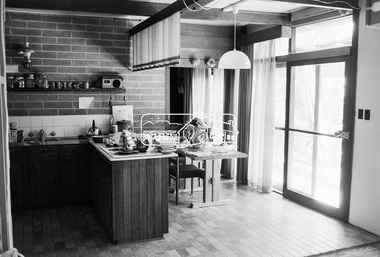 Eltham District Historical Society Inc
Photograph, 68 Mount Pleasant Road, Eltham, c.1983, 1983
An early Alistair Knox design and build, this home was purchased by George Coop in 1968. Eltham builder, Graham Rose, extended the original Alistair Knox structure over the foundation excavation dug by George. Graham organised the brick walls where required, raised all frame work and laid the steel tray roof. George did all external/internal wall cladding, made all opening windows, sliding and swinging doors, stairs and general interior timber cabinet work. Bedroom wardrobe doors came from scrapped Victorian Railways country coaches. This particular view shows the original Alistair Knox design and materials. The photo was taken where the original external wall was located and knocked down to add the extension.Digital TIFF file Scan of 35mm Ilford XP1 black and white transparencyalistair knox design, eltham, graham rose, houses, mount pleasant road -
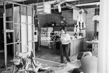 Eltham District Historical Society Inc
Photograph, 68 Mount Pleasant Road, Eltham, c.1983, 1983
An early Alistair Knox design and build, this home was purchased by George Coop in 1968. Eltham builder, Graham Rose, extended the original Alistair Knox structure over the foundation excavation dug by George. Graham organised the brick walls where required, raised all frame work and laid the steel tray roof. George did all external/internal wall cladding, made all opening windows, sliding and swinging doors, stairs and general interior timber cabinet work. Bedroom wardrobe doors came from scrapped Victorian Railways country coaches. Most of the timbers used in the extension were re-purposed from the Templestowe Cool Store and the Port Melbourne wool, hide & skin store.Digital TIFF file Scan of 35mm Ilford XP1 black and white transparencyalistair knox design, eltham, graham rose, houses, mount pleasant road -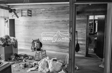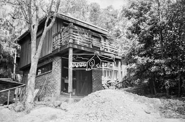
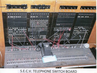 Kiewa Valley Historical Society
Photos: Kiewa Hydro Electric Scheme x 12
K.H.E.S.Photos 4 coloured and 8 black and white with the Title printed below each one. 1. S.E.C.V. Telephone Switch Board (See also KVHS 0847) 2.West Kiewa Tunnel 3. Construction of Underground Power Station 4. Pretty Vally Camp 5.Outside Kiewa House, Bogong 6. S.E.C.V. Saucer (See also KVHS 0128) 7.Insulator Disk Struck by Lightning 8. S.E.C.V. Map of the Kiewa Hydro Scheme 9.Howman's Gap Camp 10.Tunnel Excavation Face 11. Mt Beauty Townhship 1948, looking north east 12. Mt Beauty Township - no labelkiewa hydro electric scheme photos -
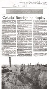 Bendigo Historical Society Inc.
Newspaper - LONG GULLY HISTORY GROUP COLLECTION: COMMUNITY FOCUS - COLONIAL BENDIGO ON DISPLAY
Copy of a newspaper article titled Colonial Bendigo on display. Date written at the top of the page Dec 1 - 1984. Article mentions an exhibition organised by the Bendigo Art Gallery of the early photographers on the gold field. Wet plate photography was used. Other mediums were also used such as engraving, artists drawings, lithography, water colours and diorama. Artists mentioned are George Rowe, S T Gill, Alex Fox, Nicholas Caire, Wet Plate Photography, Thomas Ham, Edwin Stocqueler and Ludwig Becker. There is also a photo by Nicholas Caire, taken 1875. showing the excavation of quartz reef and mine buildings near Iron bark Hill.bendigo, history, long gully history group, the long gully history group - community focus - colonial bendigo on display, bendigo art gallery, george rowe, s t gill, alex fox, nicholas caire, wet plate photography, thomas ham, edwin stocqueler, the advertiser, ludwig becker, burke and wills expedition, mine buildings near ironbark hill, victoria hill -
 Federation University Historical Collection
Plans, Plans of the Ballarat School of Mines, Lydiard Street South, Ballarat, 1953
.3) Ballarat School of Mines plan for water supply installation to prefabricated classrooms associated with the Ballarat Girls' Techncial School, April 1953 .4) Ballarat School of Mines plans for three prefabricated classrooms to be used as the Ballarat Girls' Techncial School, Hickman Street, Ballarat by Percy E. Everett, 16 December 1952. Earthworks undertaken by T.G. James. .5) Ballarat Sewerage Authority Plan of Drainage Prefabricated Class Rooms Ballarat School of Mines by Chief Architect Percy E. Everett, 13 April 1953. The plan shows basket ball court and shelter, classrooms, contours, excavations and girls toilet associated with the Ballarat Girls' Techncial School, Hickman Street, Ballarat. ballarat junior girls' technical school, ballarat girls' technical school, ballarat school of mines, hickman street, white flat, t.g. james